Bridge Statistics for Adrian, Michigan (MI)
Condition, Traffic, Stress, Structural Evaluation, Project Costs
- National Bridge Inventory (NBI) Statistics
- 38Number of bridges
- 295ft / 89.7mTotal length
- $540,000Total costs
- 165,241Total average daily traffic
- 7,235Total average daily truck traffic
- National Bridge Inventory (NBI) Registered Bridges for Adrian
- No street view available for this location
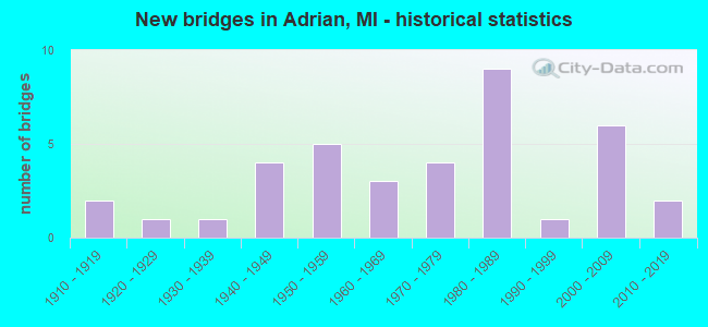
- New bridges - historical statistics
- 21910-1919
- 11920-1929
- 11930-1939
- 41940-1949
- 51950-1959
- 31960-1969
- 41970-1979
- 91980-1989
- 11990-1999
- 62000-2009
- 22010-2019
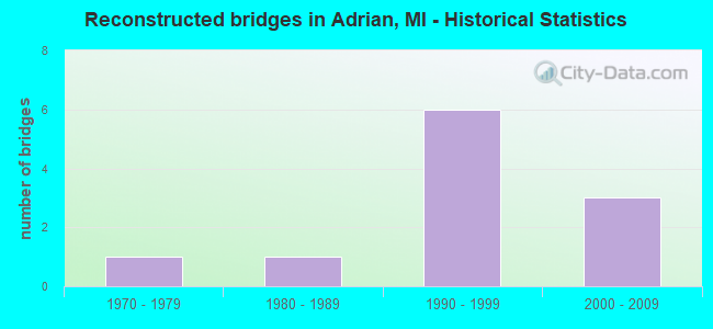
- Reconstructed bridges - Historical Statistics
- 11970-1979
- 11980-1989
- 61990-1999
- 32000-2009
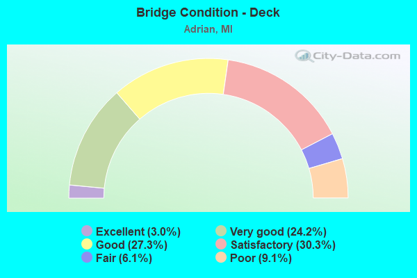
- Bridge Condition - Deck
- 3.0%Excellent
- 24.2%Very good
- 27.3%Good
- 30.3%Satisfactory
- 6.1%Fair
- 9.1%Poor
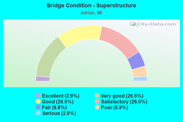
- Bridge Condition - Superstructure
- 2.9%Excellent
- 26.5%Very good
- 26.5%Good
- 26.5%Satisfactory
- 8.8%Fair
- 5.9%Poor
- 2.9%Serious
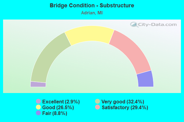
- Bridge Condition - Substructure
- 2.9%Excellent
- 32.4%Very good
- 26.5%Good
- 29.4%Satisfactory
- 8.8%Fair
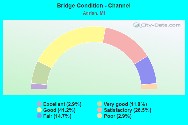
- Bridge Condition - Channel
- 2.9%Excellent
- 11.8%Very good
- 41.2%Good
- 26.5%Satisfactory
- 14.7%Fair
- 2.9%Poor
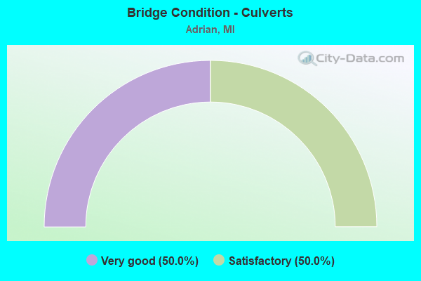
- Bridge Condition - Culverts
- 50.0%Very good
- 50.0%Satisfactory
Find on map >> Show street view
Structure Number: 553, Location: 3 MI SE OF WOODLAND (Lat: 42.683481, Lng: -85.112831), Route carried "on" structure: County highway 866, Year Built: 2007, Status: Open, Structure Length: 1.68m (5.51ft), Average Daily Traffic: 625 (year 2006), Truck Traffic: 3%, Average Future Daily Traffic: 1,025 (year 2026), Design Load: HS 25 or greater, Features Intersected: MUD CREEK, Facility Carried by Structure: COATS GROVE ROAD
Minimum Vertical Clearance: 30.48m (100.00ft), Kilometerpoint: 14.739, Lanes on structure: 2, Owner: County Highway Agency, Approaching Roadway Width: 9.1m (29.9ft), Material/Design: Prestressed concrete, Design/Construction: Box Beam or Girders - Single/Spread, Number Of Spans In Main Unit: 1, Length of Maximum Span: 15.5m (50.9ft), Curb-To-Curb Width: 9.8m (32.2ft), Out-to-Out Width: 10.7m (35.1ft)
Condition: Deck: Very good, Superstructure: Very good, Substructure: Very good, Channel: Good, Operating Rating: 78.1 metric tons, Method Used To Determine Operating Rating: Load Factor (LF) rating reported by rating factor (RF) method using MS18 loading, Inventory Rating: 47.0 metric tons, Method Used To Determine Inventory Rating: Load Factor (LF) rating reported by rating factor (RF) method using MS18 loading, Structural Evaluation: Equal to present desirable criteria, Deck Geometry: Equal to present minimum criteria, Waterway Adequacy: Equal to present desirable criteria, Approach Roadway Alignment: Equal to present desirable criteria, Designated Inspection Frequency: Every 24 months, Inspection Date: July 2021, Deck Structure Type: Concrete Cast-file-Place, Wearing Surface/Protective System: Wearing Surface: Integral Concrete, Deck Protection: Epoxy Coated Reinforcing
Find on map >> Show street view
Structure Number: 5515, Location: IN ADRIAN (OLD US-223 BR) (Lat: 41.899814, Lng: -84.039733), Route carried "on" structure: City street 2017, Year Built: 1919, Status: Open, Structure Length: 2.25m (7.38ft), Average Daily Traffic: 9,323 (year 2007), Truck Traffic: 2%, Average Future Daily Traffic: 13,464 (year 2018), Design Load: H 20, Features Intersected: S BR RAISIN RIVER, Facility Carried by Structure: W MAUMEE STREET
Minimum Vertical Clearance: 30+ m (98+ ft), Kilometerpoint: 3.088, Lanes on structure: 4, Base Highway Network: Yes (Inventory Route: 94, Subroute: 1), Owner: City or Municipal Highway Agency, Approaching Roadway Width: 13.4m (44.0ft), Material/Design: Concrete, Design/Construction: Arch - Deck, Number Of Spans In Main Unit: 1, Length of Maximum Span: 22.5m (73.8ft), Curb or Sidewalk Widths: Left: 1.8m (5.9ft), Right: 1.8m (5.9ft), Curb-To-Curb Width: 13.4m (44.0ft), Out-to-Out Width: 18.4m (60.4ft)
Condition: Superstructure: Satisfactory, Substructure: Satisfactory, Channel: Good, Operating Rating: 88.8 metric tons, Method Used To Determine Operating Rating: Load Factor (LF) rating reported by rating factor (RF) method using MS18 loading, Inventory Rating: 53.1 metric tons, Method Used To Determine Inventory Rating: Load Factor (LF) rating reported by rating factor (RF) method using MS18 loading, Structural Evaluation: Equal to present minimum criteria, Deck Geometry: High priority of replacement, Waterway Adequacy: Better than present minimum criteria, Approach Roadway Alignment: Better than present minimum criteria, Designated Inspection Frequency: Every 24 months, Inspection Date: March 2021, Deck Structure Type: Concrete Cast-file-Place, Wearing Surface/Protective System: Wearing Surface: Bituminous
Find on map >> Show street view
Structure Number: 5521, Location: IN ADRIAN (Lat: 41.888361, Lng: -84.059858), Route carried "on" structure: US 223, Year Built: 2006, Status: Open, Structure Length: 13.80m (45.28ft), Average Daily Traffic: 13,595 (year 2007), Truck Traffic: 14%, Average Future Daily Traffic: 15,500 (year 2025), Design Load: HS 25 or greater, Features Intersected: MDOT RR COR & M-34
Minimum Vertical Clearance: 30.48m (100.00ft), Kilometerpoint: 31.169, Lanes on structure: 2, Lanes under structure: 4, Base Highway Network: Yes (Inventory Route: 94, Subroute: 2), Owner: State Highway Agency, Approaching Roadway Width: 12.8m (42.0ft), Skew: 9 degrees, Material/Design: Prestressed concrete, Design/Construction: Stringer/Multi-beam, Number Of Spans In Main Unit: 6, Length of Maximum Span: 31.4m (103.0ft), Curb-To-Curb Width: 13.4m (44.0ft), Out-to-Out Width: 14.5m (47.6ft)
Condition: Deck: Satisfactory, Superstructure: Satisfactory, Substructure: Satisfactory, Operating Rating: 86.8 metric tons, Method Used To Determine Operating Rating: Load Factor (LF) rating reported by rating factor (RF) method using MS18 loading, Inventory Rating: 51.8 metric tons, Method Used To Determine Inventory Rating: Load Factor (LF) rating reported by rating factor (RF) method using MS18 loading, Structural Evaluation: Equal to present minimum criteria, Deck Geometry: Equal to present minimum criteria, Underclear: Meets minimum limits, Approach Roadway Alignment: Equal to present desirable criteria, Designated Inspection Frequency: Every 24 months, Inspection Date: July 2020, Deck Structure Type: Concrete Cast-file-Place, Wearing Surface/Protective System: Deck Protection: Epoxy Coated Reinforcing
Find on map >> Show street view
Structure Number: 553, Location: IN ADRIAN (N MAIN ST) (Lat: 41.909683, Lng: -84.029725), Route carried "on" structure: State highway 52, Year Built: 1948, Year Reconstructed: 2006, Status: Open, Structure Length: 3.96m (12.99ft), Average Daily Traffic: 17,411 (year 2007), Truck Traffic: 2%, Average Future Daily Traffic: 27,518 (year 2018), Design Load: HS 20, Features Intersected: S BR RAISIN RIVER
Minimum Vertical Clearance: 30.48m (100.00ft), Kilometerpoint: 1.666, Lanes on structure: 5, Owner: State Highway Agency, Approaching Roadway Width: 22.9m (75.1ft), Material/Design: Steel, Design/Construction: Stringer/Multi-beam, Number Of Spans In Main Unit: 3, Length of Maximum Span: 18.3m (60.0ft), Curb or Sidewalk Widths: Left: 1.5m (4.9ft), Right: 1.5m (4.9ft), Curb-To-Curb Width: 18.0m (59.1ft), Out-to-Out Width: 21.8m (71.5ft)
Condition: Deck: Satisfactory, Superstructure: Fair, Substructure: Satisfactory, Channel: Satisfactory, Operating Rating: 60.6 metric tons, Method Used To Determine Operating Rating: Load Factor (LF) rating reported by rating factor (RF) method using MS18 loading, Inventory Rating: 36.3 metric tons, Method Used To Determine Inventory Rating: Load Factor (LF) rating reported by rating factor (RF) method using MS18 loading, Structural Evaluation: Somewhat better than minimum adequacy, Deck Geometry: High priority of replacement, Waterway Adequacy: Equal to present minimum criteria, Approach Roadway Alignment: Equal to present desirable criteria, Designated Inspection Frequency: Every 24 months, Inspection Date: July 2020, Deck Structure Type: Concrete Cast-file-Place, Wearing Surface/Protective System: Wearing Surface: Latex Concrete, Deck Protection: Epoxy Coated Reinforcing
Find on map >> Show street view
Structure Number: 5531, Location: 0.8 M N OF ADRIAN GARAGE (Lat: 41.927714, Lng: -84.011644), Route carried "on" structure: State highway 52, Year Built: 1919, Year Reconstructed: 1984, Status: Open, Structure Length: 1.70m (5.58ft), Average Daily Traffic: 18,099 (year 2007), Truck Traffic: 3%, Average Future Daily Traffic: 24,098 (year 2018), Design Load: HS 20, Features Intersected: BEAVER CREEK
Minimum Vertical Clearance: 30.48m (100.00ft), Kilometerpoint: 4.279, Lanes on structure: 5, Base Highway Network: Yes (Inventory Route: 94, Subroute: 4), Owner: State Highway Agency, Approaching Roadway Width: 21.0m (68.9ft), Material/Design: Concrete, Design/Construction: Arch - Deck, Number Of Spans In Main Unit: 1, Length of Maximum Span: 17.0m (55.8ft), Curb or Sidewalk Widths: Left: 1.5m (4.9ft), Right: 1.5m (4.9ft), Curb-To-Curb Width: 18.0m (59.1ft), Out-to-Out Width: 21.6m (70.9ft)
Condition: Deck: Satisfactory, Superstructure: Fair, Substructure: Satisfactory, Channel: Fair, Operating Rating: 53.0 metric tons, Method Used To Determine Operating Rating: Load Factor (LF), Inventory Rating: 31.8 metric tons, Method Used To Determine Inventory Rating: Load Factor (LF), Structural Evaluation: Somewhat better than minimum adequacy, Deck Geometry: High priority of replacement, Waterway Adequacy: Equal to present desirable criteria, Approach Roadway Alignment: Equal to present desirable criteria, Designated Inspection Frequency: Every 24 months, Inspection Date: July 2020, Bridge Improvement Cost: $15,000, Deck Structure Type: Concrete Cast-file-Place, Wearing Surface/Protective System: Wearing Surface: Bituminous, Deck Protection: Epoxy Coated Reinforcing
Find on map >> Show street view
Structure Number: 5564, Location: 0.5 MI EAST OF WHIG HWY (Lat: 41.858839, Lng: -84.112550), Route carried "on" structure: County highway 4640, Year Built: 1974, Status: Open, Structure Length: 2.13m (6.99ft), Average Daily Traffic: 171 (year 2012), Truck Traffic: 2%, Average Future Daily Traffic: 1,500 (year 2031), Design Load: H 20, Features Intersected: SOUTH BRANCH RAISIN RIVR, Facility Carried by Structure: CARLETON RD
Minimum Vertical Clearance: 30.48m (100.00ft), Kilometerpoint: 4.046, Lanes on structure: 2, Owner: County Highway Agency, Approaching Roadway Width: 10.1m (33.1ft), Material/Design: Prestressed concrete, Design/Construction: Box Beam or Girders - Multiple, Number Of Spans In Main Unit: 1, Length of Maximum Span: 21.3m (69.9ft), Curb-To-Curb Width: 9.1m (29.9ft), Out-to-Out Width: 9.5m (31.2ft)
Condition: Deck: Good, Superstructure: Good, Substructure: Very good, Channel: Poor, Operating Rating: 52.6 metric tons, Method Used To Determine Operating Rating: Load Factor (LF), Inventory Rating: 31.6 metric tons, Method Used To Determine Inventory Rating: Load Factor (LF), Structural Evaluation: Better than present minimum criteria, Deck Geometry: Equal to present minimum criteria, Waterway Adequacy: Equal to present desirable criteria, Approach Roadway Alignment: Equal to present desirable criteria, Designated Inspection Frequency: Every 24 months, Inspection Date: July 2021, Deck Structure Type: Concrete Precast Panels, Wearing Surface/Protective System: Wearing Surface: Bituminous
Find on map >> Show street view
Structure Number: 5566, Location: 0.25 MI WEST OF US-223 (Lat: 41.874719, Lng: -84.052189), Route carried "on" structure: County highway , Year Built: 2009, Status: Open, Structure Length: 2.77m (9.09ft), Average Daily Traffic: 4,136 (year 2012), Truck Traffic: 2%, Average Future Daily Traffic: 6,300 (year 2031), Design Load: HS 20+Mod, Features Intersected: SOUTH BR RAISIN RIVER, Facility Carried by Structure: CADMUS RD
Minimum Vertical Clearance: 30.48m (100.00ft), Kilometerpoint: 9.813, Lanes on structure: 2, Owner: County Highway Agency, Approaching Roadway Width: 10.4m (34.1ft), Material/Design: Prestressed concrete, Design/Construction: Box Beam or Girders - Multiple, Number Of Spans In Main Unit: 1, Length of Maximum Span: 27.3m (89.6ft), Curb-To-Curb Width: 10.7m (35.1ft), Out-to-Out Width: 11.3m (37.1ft)
Condition: Deck: Very good, Superstructure: Very good, Substructure: Very good, Channel: Good, Inventory Rating: 62.6 metric tons, Method Used To Determine Inventory Rating: Load Factor (LF), Structural Evaluation: Equal to present desirable criteria, Deck Geometry: Somewhat better than minimum adequacy, Waterway Adequacy: Equal to present desirable criteria, Approach Roadway Alignment: Better than present minimum criteria, Designated Inspection Frequency: Every 24 months, Inspection Date: May 2021, Deck Structure Type: Concrete Cast-file-Place, Wearing Surface/Protective System: Wearing Surface: Monolithic Concrete, Deck Protection: Epoxy Coated Reinforcing
Find on map >> Show street view
Structure Number: 5569, Location: 0.1 MI EAST OF HUMPHREY (Lat: 41.885072, Lng: -83.970783), Route carried "on" structure: County highway 4644, Year Built: 1955, Status: Posted for load, Structure Length: 3.65m (11.98ft), Average Daily Traffic: 6,795 (year 2020), Truck Traffic: 7%, Average Future Daily Traffic: 7,508 (year 2040), Design Load: H 20, Features Intersected: RIVER RAISIN, Facility Carried by Structure: DEERFIELD RD
Minimum Vertical Clearance: 30.48m (100.00ft), Kilometerpoint: 6.055, Lanes on structure: 2, Owner: County Highway Agency, Approaching Roadway Width: 10.1m (33.1ft), Material/Design: Concrete continuous, Design/Construction: Tee Beam, Number Of Spans In Main Unit: 3, Length of Maximum Span: 14.9m (48.9ft), Curb or Sidewalk Widths: Left: 0.4m (1.3ft), Right: 0.5m (1.6ft), Curb-To-Curb Width: 7.0m (23.0ft), Out-to-Out Width: 8.9m (29.2ft)
Condition: Deck: Fair, Superstructure: Satisfactory, Substructure: Fair, Channel: Fair, Operating Rating: 26.6 metric tons, Method Used To Determine Operating Rating: Load Factor (LF) rating reported by rating factor (RF) method using MS18 loading, Inventory Rating: 16.2 metric tons, Method Used To Determine Inventory Rating: Load Factor (LF) rating reported by rating factor (RF) method using MS18 loading, Structural Evaluation: Meets minimum limits, Deck Geometry: High priority of replacement, Waterway Adequacy: Better than present minimum criteria, Approach Roadway Alignment: Somewhat better than minimum adequacy, Bridge Posting: Required (Relationship of Operating Rating to Maximum Legal Load: 20.0 - 29.9% below), Designated Inspection Frequency: Every 12 months, Underwater Inspection Frequency: Every 60 months, Inspection Date: April 2021, Underwater Inspection Date: October 2019, Deck Structure Type: Concrete Precast Panels, Wearing Surface/Protective System: Wearing Surface: Bituminous
Find on map >> Show street view
Structure Number: 5573, Location: 0.2 MI EAST OF TOWNLINE (Lat: 41.929486, Lng: -84.127119), Route carried "on" structure: County highway 4656, Year Built: 1971, Year Reconstructed: 1995, Status: Open, Structure Length: 1.28m (4.20ft), Average Daily Traffic: 2,085 (year 2011), Truck Traffic: 4%, Average Future Daily Traffic: 3,600 (year 2031), Design Load: HS 20, Features Intersected: WOLF CREEK, Facility Carried by Structure: BURTON RD
Minimum Vertical Clearance: 30.48m (100.00ft), Kilometerpoint: 16.308, Lanes on structure: 2, Owner: County Highway Agency, Approaching Roadway Width: 10.1m (33.1ft), Material/Design: Wood or Timber, Design/Construction: Slab, Number Of Spans In Main Unit: 2, Length of Maximum Span: 6.4m (21.0ft), Curb-To-Curb Width: 10.1m (33.1ft), Out-to-Out Width: 10.1m (33.1ft)
Condition: Deck: Very good, Superstructure: Very good, Substructure: Fair, Channel: Fair, Operating Rating: 66.9 metric tons, Method Used To Determine Operating Rating: Allowable Stress (AS), Inventory Rating: 48.7 metric tons, Method Used To Determine Inventory Rating: Allowable Stress (AS), Structural Evaluation: Somewhat better than minimum adequacy, Deck Geometry: Meets minimum limits, Waterway Adequacy: Equal to present desirable criteria, Approach Roadway Alignment: Equal to present minimum criteria, Designated Inspection Frequency: Every 24 months, Inspection Date: June 2021, Deck Structure Type: Corrugated Steel, Wearing Surface/Protective System: Wearing Surface: Bituminous
Find on map >> Show street view
Structure Number: 5596, Location: SOUTH OF COUNTRY CLUB RD (Lat: 41.912942, Lng: -84.079122), Route carried "on" structure: County highway 2017, Year Built: 1981, Status: Posted for load, Structure Length: 1.92m (6.30ft), Average Daily Traffic: 10,021 (year 2020), Truck Traffic: 3%, Average Future Daily Traffic: 11,400 (year 2040), Design Load: HS 20, Features Intersected: WOLF CREEK, Facility Carried by Structure: WOLF CREEK HWY
Minimum Vertical Clearance: 30.48m (100.00ft), Kilometerpoint: 5.227, Lanes on structure: 2, Owner: County Highway Agency, Approaching Roadway Width: 11.9m (39.0ft), Skew: 2 degrees, Material/Design: Prestressed concrete, Design/Construction: Box Beam or Girders - Multiple, Number Of Spans In Main Unit: 1, Length of Maximum Span: 17.9m (58.7ft), Curb or Sidewalk Widths: Left: 1.5m (4.9ft), Right: 0.0m, Curb-To-Curb Width: 11.9m (39.0ft), Out-to-Out Width: 15.2m (49.9ft)
Condition: Deck: Poor, Superstructure: Poor, Substructure: Good, Channel: Very good, Operating Rating: 23.7 metric tons, Method Used To Determine Operating Rating: Load and Resistance Factor Rating (LRFR) rating reported by rating factor(RF) method using HL-93 loadings, Inventory Rating: 16.8 metric tons, Method Used To Determine Inventory Rating: Load and Resistance Factor Rating (LRFR) rating reported by rating factor(RF) method using HL-93 loadings, Structural Evaluation: Meets minimum limits, Deck Geometry: Somewhat better than minimum adequacy, Waterway Adequacy: Equal to present minimum criteria, Approach Roadway Alignment: Better than present minimum criteria, Bridge Posting: Required (Relationship of Operating Rating to Maximum Legal Load: 30.0 - 39.9% below), Designated Inspection Frequency: Every 12 months, Inspection Date: May 2021, Deck Structure Type: Concrete Precast Panels, Wearing Surface/Protective System: Wearing Surface: Latex Concrete
Find on map >> Show street view
Structure Number: 5597, Location: 0.5 MI NORTH OF HUNT RD (Lat: 41.935997, Lng: -84.104164), Route carried "on" structure: County highway 4641, Year Built: 1983, Status: Open, Structure Length: 0.91m (2.99ft), Average Daily Traffic: 1,749 (year 2011), Truck Traffic: 1%, Average Future Daily Traffic: 5,000 (year 2031), Design Load: HS 20, Features Intersected: BLACK CREEK, Facility Carried by Structure: WOLF CREEK HWY
Minimum Vertical Clearance: 30.48m (100.00ft), Kilometerpoint: 2.561, Lanes on structure: 2, Owner: County Highway Agency, Approaching Roadway Width: 9.1m (29.9ft), Material/Design: Wood or Timber, Design/Construction: Slab, Number Of Spans In Main Unit: 1, Length of Maximum Span: 9.1m (29.9ft), Curb-To-Curb Width: 9.1m (29.9ft), Out-to-Out Width: 9.5m (31.2ft)
Condition: Deck: Good, Superstructure: Good, Substructure: Fair, Channel: Fair, Operating Rating: 52.9 metric tons, Method Used To Determine Operating Rating: Allowable Stress (AS), Inventory Rating: 37.3 metric tons, Method Used To Determine Inventory Rating: Allowable Stress (AS), Structural Evaluation: Somewhat better than minimum adequacy, Deck Geometry: Somewhat better than minimum adequacy, Waterway Adequacy: Somewhat better than minimum adequacy, Approach Roadway Alignment: Somewhat better than minimum adequacy, Designated Inspection Frequency: Every 24 months, Inspection Date: June 2021, Deck Structure Type: Wood or Timber, Wearing Surface/Protective System: Wearing Surface: Bituminous, Deck Protection: Other
Find on map >> Show street view
Structure Number: 5598, Location: NORTH OF DEERFIELD RD (Lat: 41.890392, Lng: -84.004361), Route carried "on" structure: County highway 2017, Year Built: 1994, Status: Open, Structure Length: 3.47m (11.38ft), Average Daily Traffic: 3,962 (year 2008), Truck Traffic: 15%, Average Future Daily Traffic: 7,800 (year 2031), Design Load: HS 25 or greater, Features Intersected: PENN-CENTRAL RAILROAD, Facility Carried by Structure: PARR HWY
Minimum Vertical Clearance: 30.48m (100.00ft), Kilometerpoint: 1.983, Lanes on structure: 2, Owner: County Highway Agency, Approaching Roadway Width: 11.9m (39.0ft), Skew: 1 degrees, Material/Design: Prestressed concrete, Design/Construction: Box Beam or Girders - Multiple, Number Of Spans In Main Unit: 3, Length of Maximum Span: 11.5m (37.7ft), Curb-To-Curb Width: 11.0m (36.1ft), Out-to-Out Width: 12.5m (41.0ft)
Condition: Deck: Very good, Superstructure: Very good, Substructure: Very good, Operating Rating: 90.5 metric tons, Method Used To Determine Operating Rating: Load Factor (LF), Inventory Rating: 54.3 metric tons, Method Used To Determine Inventory Rating: Load Factor (LF), Structural Evaluation: Equal to present desirable criteria, Deck Geometry: Somewhat better than minimum adequacy, Approach Roadway Alignment: Equal to present desirable criteria, Designated Inspection Frequency: Every 24 months, Inspection Date: January 2022, Deck Structure Type: Concrete Cast-file-Place, Wearing Surface/Protective System: Wearing Surface: Monolithic Concrete, Membrane: Other, Deck Protection: Epoxy Coated Reinforcing
Find on map >> Show street view
Structure Number: 5599, Location: 0.5 MI NORTH OF OAKWOOD R (Lat: 41.917781, Lng: -84.010133), Route carried "on" structure: County highway 2017, Year Built: 1959, Status: Open, Structure Length: 4.02m (13.19ft), Average Daily Traffic: 2,078 (year 2011), Truck Traffic: 4%, Average Future Daily Traffic: 3,000 (year 2031), Design Load: H 20, Features Intersected: RIVER RAISIN, Facility Carried by Structure: HOWELL HWY
Minimum Vertical Clearance: 30.48m (100.00ft), Kilometerpoint: 1.394, Lanes on structure: 2, Owner: County Highway Agency, Approaching Roadway Width: 10.1m (33.1ft), Material/Design: Prestressed concrete, Design/Construction: Box Beam or Girders - Multiple, Number Of Spans In Main Unit: 3, Length of Maximum Span: 13.4m (44.0ft), Curb or Sidewalk Widths: Left: 0.4m (1.3ft), Right: 0.4m (1.3ft), Curb-To-Curb Width: 7.9m (25.9ft), Out-to-Out Width: 9.3m (30.5ft)
Condition: Deck: Satisfactory, Superstructure: Satisfactory, Substructure: Good, Channel: Good, Operating Rating: 53.2 metric tons, Method Used To Determine Operating Rating: Load Factor (LF), Inventory Rating: 31.9 metric tons, Method Used To Determine Inventory Rating: Load Factor (LF), Structural Evaluation: Equal to present minimum criteria, Deck Geometry: High priority of corrective action, Waterway Adequacy: Equal to present desirable criteria, Approach Roadway Alignment: Equal to present desirable criteria, Designated Inspection Frequency: Every 24 months, Inspection Date: June 2021, Deck Structure Type: Concrete Precast Panels, Wearing Surface/Protective System: Wearing Surface: Bituminous
Find on map >> Show street view
Structure Number: 56, Location: 0.1 MI WEST OF CARSON HWY (Lat: 41.934128, Lng: -84.025503), Route carried "on" structure: County highway 2017, Year Built: 2005, Status: Open, Structure Length: 1.68m (5.51ft), Average Daily Traffic: 3,350 (year 2013), Truck Traffic: 1%, Average Future Daily Traffic: 6,000 (year 2031), Design Load: HS 25 or greater, Features Intersected: BEAVER CREEK, Facility Carried by Structure: VALLEY RD
Minimum Vertical Clearance: 30.48m (100.00ft), Kilometerpoint: 0.832, Lanes on structure: 2, Owner: County Highway Agency, Approaching Roadway Width: 10.4m (34.1ft), Material/Design: Concrete, Design/Construction: Culvert, Number Of Spans In Main Unit: 1, Length of Maximum Span: 16.8m (55.1ft), Curb-To-Curb Width: 10.4m (34.1ft), Out-to-Out Width: 35.1m (115.2ft)
Condition: Channel: Very good, Culverts: Very good, Operating Rating: 68.0 metric tons, Method Used To Determine Operating Rating: Load Factor (LF), Inventory Rating: 40.8 metric tons, Method Used To Determine Inventory Rating: Load Factor (LF), Structural Evaluation: Equal to present desirable criteria, Deck Geometry: Somewhat better than minimum adequacy, Waterway Adequacy: Equal to present minimum criteria, Approach Roadway Alignment: Equal to present minimum criteria, Designated Inspection Frequency: Every 24 months, Inspection Date: June 2021, Deck Structure Type: Concrete Precast Panels, Wearing Surface/Protective System: Wearing Surface: Bituminous
Find on map >> Show street view
Structure Number: 561, Location: 0.4 MI W OF KNIGHT HWY (Lat: 41.949214, Lng: -84.094844), Route carried "on" structure: County highway , Year Built: 1965, Year Reconstructed: 2006, Status: Open, Structure Length: 0.70m (2.30ft), Average Daily Traffic: 86 (year 2013), Truck Traffic: 1%, Average Future Daily Traffic: 250 (year 2031), Design Load: HS 20, Features Intersected: BLACK CREEK, Facility Carried by Structure: BRAZEE RD
Minimum Vertical Clearance: 30.48m (100.00ft), Kilometerpoint: 0.774, Lanes on structure: 2, Owner: County Highway Agency, Approaching Roadway Width: 7.0m (23.0ft), Material/Design: Wood or Timber, Design/Construction: Slab, Number Of Spans In Main Unit: 1, Length of Maximum Span: 6.4m (21.0ft), Curb or Sidewalk Widths: Left: 0.2m (0.7ft), Right: 0.2m (0.7ft), Curb-To-Curb Width: 9.1m (29.9ft), Out-to-Out Width: 9.5m (31.2ft)
Condition: Deck: Very good, Superstructure: Very good, Substructure: Good, Channel: Satisfactory, Operating Rating: 53.2 metric tons, Method Used To Determine Operating Rating: Allowable Stress (AS), Inventory Rating: 38.1 metric tons, Method Used To Determine Inventory Rating: Allowable Stress (AS), Structural Evaluation: Better than present minimum criteria, Deck Geometry: Better than present minimum criteria, Waterway Adequacy: Better than present minimum criteria, Approach Roadway Alignment: Better than present minimum criteria, Designated Inspection Frequency: Every 24 months, Inspection Date: June 2021, Deck Structure Type: Wood or Timber, Wearing Surface/Protective System: Wearing Surface: Bituminous, Deck Protection: Other
Find on map >> Show street view
Structure Number: 5614, Location: 0.2 MI N OF US-223 (Lat: 41.907561, Lng: -84.089247), Route carried "on" structure: County highway , Year Built: 1989, Status: Open, Structure Length: 1.70m (5.58ft), Average Daily Traffic: 130 (year 2013), Truck Traffic: 1%, Average Future Daily Traffic: 300 (year 2031), Design Load: HS 20, Features Intersected: WOLF CREEK, Facility Carried by Structure: HAMILTON HWY
Minimum Vertical Clearance: 30.48m (100.00ft), Kilometerpoint: 0.230, Lanes on structure: 2, Owner: County Highway Agency, Approaching Roadway Width: 9.1m (29.9ft), Skew: 2 degrees, Material/Design: Prestressed concrete, Design/Construction: Box Beam or Girders - Multiple, Number Of Spans In Main Unit: 1, Length of Maximum Span: 15.8m (51.8ft), Curb-To-Curb Width: 9.1m (29.9ft), Out-to-Out Width: 9.4m (30.8ft)
Condition: Deck: Good, Superstructure: Very good, Substructure: Very good, Channel: Very good, Operating Rating: 67.2 metric tons, Method Used To Determine Operating Rating: Load Factor (LF), Inventory Rating: 40.3 metric tons, Method Used To Determine Inventory Rating: Load Factor (LF), Structural Evaluation: Equal to present desirable criteria, Deck Geometry: Equal to present minimum criteria, Waterway Adequacy: Better than present minimum criteria, Approach Roadway Alignment: Equal to present desirable criteria, Designated Inspection Frequency: Every 24 months, Inspection Date: June 2021, Deck Structure Type: Concrete Precast Panels, Wearing Surface/Protective System: Wearing Surface: Bituminous, Deck Protection: Other
Find on map >> Show street view
Structure Number: 5615, Location: 0.3 MI N OF COUNTRY CLUBR (Lat: 41.917217, Lng: -84.064792), Route carried "on" structure: County highway , Year Built: 1986, Status: Open, Structure Length: 1.82m (5.97ft), Average Daily Traffic: 3,827 (year 2011), Truck Traffic: 1%, Average Future Daily Traffic: 4,500 (year 2031), Design Load: HS 20, Features Intersected: WOLF CREEK, Facility Carried by Structure: TIPTON HWY
Minimum Vertical Clearance: 30.48m (100.00ft), Kilometerpoint: 0.488, Lanes on structure: 2, Owner: County Highway Agency, Approaching Roadway Width: 9.1m (29.9ft), Skew: 1 degrees, Material/Design: Prestressed concrete, Design/Construction: Box Beam or Girders - Multiple, Number Of Spans In Main Unit: 1, Length of Maximum Span: 18.2m (59.7ft), Curb-To-Curb Width: 11.9m (39.0ft), Out-to-Out Width: 13.2m (43.3ft)
Condition: Deck: Good, Superstructure: Good, Substructure: Very good, Channel: Good, Operating Rating: 58.6 metric tons, Method Used To Determine Operating Rating: Load Factor (LF), Inventory Rating: 35.2 metric tons, Method Used To Determine Inventory Rating: Load Factor (LF), Structural Evaluation: Better than present minimum criteria, Deck Geometry: Somewhat better than minimum adequacy, Waterway Adequacy: Equal to present desirable criteria, Approach Roadway Alignment: Equal to present minimum criteria, Designated Inspection Frequency: Every 24 months, Inspection Date: July 2021, Deck Structure Type: Concrete Precast Panels, Wearing Surface/Protective System: Wearing Surface: Bituminous, Membrane: Preformed Fabric, Deck Protection: Epoxy Coated Reinforcing
Find on map >> Show street view
Structure Number: 5616, Location: 0.3 MI NORTH OF MOORE RD (Lat: 41.946350, Lng: -84.035539), Route carried "on" structure: County highway , Year Built: 2016, Status: Open, Structure Length: 1.52m (4.99ft), Average Daily Traffic: 1,059 (year 2015), Truck Traffic: 1%, Average Future Daily Traffic: 1,735 (year 2035), Design Load: Greater than HL93, Features Intersected: BEAVER CREEK, Facility Carried by Structure: BENT OAK HWY
Minimum Vertical Clearance: 30.48m (100.00ft), Kilometerpoint: 4.498, Lanes on structure: 2, Owner: County Highway Agency, Approaching Roadway Width: 9.7m (31.8ft), Skew: 3 degrees, Material/Design: Prestressed concrete, Design/Construction: Box Beam or Girders - Multiple, Number Of Spans In Main Unit: 1, Length of Maximum Span: 14.7m (48.2ft), Curb-To-Curb Width: 9.8m (32.2ft), Out-to-Out Width: 10.6m (34.8ft)
Condition: Deck: Very good, Superstructure: Very good, Substructure: Very good, Channel: Very good, Operating Rating: 62.2 metric tons, Method Used To Determine Operating Rating: Load and Resistance Factor Rating (LRFR) rating reported by rating factor(RF) method using HL-93 loadings, Inventory Rating: 48.0 metric tons, Method Used To Determine Inventory Rating: Load and Resistance Factor Rating (LRFR) rating reported by rating factor(RF) method using HL-93 loadings, Structural Evaluation: Equal to present desirable criteria, Deck Geometry: Somewhat better than minimum adequacy, Waterway Adequacy: Equal to present desirable criteria, Approach Roadway Alignment: Equal to present desirable criteria, Length Of Structure Improvement: 1.59m (5.22ft), Designated Inspection Frequency: Every 24 months, Inspection Date: September 2020, Bridge Improvement Cost: $240,000, Roadway Improvement Cost: $40,000, Total Project Cost: $240,000, Deck Structure Type: Concrete Cast-file-Place, Wearing Surface/Protective System: Wearing Surface: Monolithic Concrete, Deck Protection: Epoxy Coated Reinforcing
Find on map >> Show street view
Structure Number: 5617, Location: 0.1 MI E OF BENT OAK HWY (Lat: 41.922122, Lng: -84.032286), Route carried "on" structure: County highway , Year Built: 1962, Status: Posted for load, Structure Length: 1.37m (4.49ft), Average Daily Traffic: 1,775 (year 2019), Truck Traffic: 1%, Average Future Daily Traffic: 3,000 (year 2039), Features Intersected: BEAVER CREEK, Facility Carried by Structure: CARSON HWY
Minimum Vertical Clearance: 30.48m (100.00ft), Kilometerpoint: 0.274, Lanes on structure: 2, Owner: County Highway Agency, Approaching Roadway Width: 9.1m (29.9ft), Skew: 4 degrees, Material/Design: Prestressed concrete, Design/Construction: Box Beam or Girders - Multiple, Number Of Spans In Main Unit: 1, Length of Maximum Span: 13.1m (43.0ft), Curb-To-Curb Width: 7.9m (25.9ft), Out-to-Out Width: 8.2m (26.9ft)
Condition: Deck: Poor, Superstructure: Serious, Substructure: Good, Channel: Satisfactory, Operating Rating: 24.6 metric tons, Method Used To Determine Operating Rating: Load and Resistance Factor Rating (LRFR) rating reported by rating factor(RF) method using HL-93 loadings, Inventory Rating: 19.1 metric tons, Method Used To Determine Inventory Rating: Load and Resistance Factor Rating (LRFR) rating reported by rating factor(RF) method using HL-93 loadings, Structural Evaluation: High priority of corrective action, Deck Geometry: Meets minimum limits, Waterway Adequacy: Equal to present desirable criteria, Approach Roadway Alignment: Somewhat better than minimum adequacy, Bridge Posting: Required (Relationship of Operating Rating to Maximum Legal Load: 20.0 - 29.9% below), Designated Inspection Frequency: Every 6 months, Inspection Date: December 2021, Deck Structure Type: Concrete Precast Panels, Wearing Surface/Protective System: Wearing Surface: Bituminous
Find on map >> Show street view
Structure Number: 5618, Location: 0.2 MI E OF TIPTON HWY (Lat: 41.918492, Lng: -84.059386), Route carried "on" structure: County highway , Year Built: 1966, Status: Posted for load, Structure Length: 1.22m (4.00ft), Average Daily Traffic: 120 (year 2001), Average Future Daily Traffic: 180 (year 2031), Features Intersected: WOLF CREEK, Facility Carried by Structure: BIRNWICK RD
Minimum Vertical Clearance: 30.48m (100.00ft), Kilometerpoint: 0.616, Lanes on structure: 2, Owner: County Highway Agency, Approaching Roadway Width: 7.9m (25.9ft), Material/Design: Prestressed concrete, Design/Construction: Box Beam or Girders - Multiple, Number Of Spans In Main Unit: 1, Length of Maximum Span: 11.5m (37.7ft), Curb-To-Curb Width: 7.0m (23.0ft), Out-to-Out Width: 7.3m (24.0ft)
Condition: Deck: Poor, Superstructure: Poor, Substructure: Good, Channel: Satisfactory, Operating Rating: 23.5 metric tons, Method Used To Determine Operating Rating: Load Factor (LF), Inventory Rating: 14.1 metric tons, Method Used To Determine Inventory Rating: Load Factor (LF), Structural Evaluation: Meets minimum limits, Deck Geometry: Meets minimum limits, Waterway Adequacy: Equal to present desirable criteria, Approach Roadway Alignment: Equal to present minimum criteria, Bridge Posting: Required (Relationship of Operating Rating to Maximum Legal Load: 10.0 - 19.9% below), Designated Inspection Frequency: Every 12 months, Inspection Date: June 2021, Deck Structure Type: Concrete Precast Panels, Wearing Surface/Protective System: Wearing Surface: Bituminous
Find on map >> Show street view
Structure Number: 5627, Location: 0.3 MI. EAST OF SWORD HWY (Lat: 41.873000, Lng: -84.134336), Route carried "on" structure: County highway , Year Built: 1978, Status: Open, Structure Length: 1.82m (5.97ft), Average Daily Traffic: 1,520 (year 2006), Truck Traffic: 3%, Average Future Daily Traffic: 3,000 (year 2025), Features Intersected: HAZEN CREEK, Facility Carried by Structure: CADMUS RD.
Minimum Vertical Clearance: 30.48m (100.00ft), Kilometerpoint: 2.992, Lanes on structure: 2, Owner: County Highway Agency, Approaching Roadway Width: 8.5m (27.9ft), Material/Design: Prestressed concrete, Design/Construction: Box Beam or Girders - Multiple, Number Of Spans In Main Unit: 1, Length of Maximum Span: 17.6m (57.7ft), Curb-To-Curb Width: 7.3m (24.0ft), Out-to-Out Width: 7.4m (24.3ft)
Condition: Deck: Good, Superstructure: Good, Substructure: Very good, Channel: Satisfactory, Operating Rating: 51.4 metric tons, Method Used To Determine Operating Rating: Load Factor (LF), Inventory Rating: 30.9 metric tons, Method Used To Determine Inventory Rating: Load Factor (LF), Structural Evaluation: Better than present minimum criteria, Deck Geometry: Meets minimum limits, Waterway Adequacy: Better than present minimum criteria, Approach Roadway Alignment: Better than present minimum criteria, Designated Inspection Frequency: Every 24 months, Inspection Date: July 2020, Deck Structure Type: Concrete Precast Panels, Wearing Surface/Protective System: Wearing Surface: Bituminous
Find on map >> Show street view
Structure Number: 5629, Location: 0.3 MI S OF CADMUS RD (Lat: 41.868936, Lng: -84.140600), Route carried "on" structure: County highway , Year Built: 1987, Status: Open, Structure Length: 1.70m (5.58ft), Average Daily Traffic: 120 (year 2006), Truck Traffic: 1%, Average Future Daily Traffic: 300 (year 2025), Design Load: HS 20, Features Intersected: SOUTH BR OF RAISIN RIVER, Facility Carried by Structure: SWORD HWY
Minimum Vertical Clearance: 30.48m (100.00ft), Kilometerpoint: 6.009, Lanes on structure: 2, Owner: County Highway Agency, Approaching Roadway Width: 9.1m (29.9ft), Skew: 2 degrees, Material/Design: Prestressed concrete, Design/Construction: Box Beam or Girders - Multiple, Number Of Spans In Main Unit: 1, Length of Maximum Span: 15.8m (51.8ft), Curb-To-Curb Width: 9.4m (30.8ft), Out-to-Out Width: 9.4m (30.8ft)
Condition: Deck: Good, Superstructure: Satisfactory, Substructure: Very good, Channel: Good, Operating Rating: 35.3 metric tons, Method Used To Determine Operating Rating: Load and Resistance Factor Rating (LRFR) rating reported by rating factor(RF) method using HL-93 loadings, Inventory Rating: 27.2 metric tons, Method Used To Determine Inventory Rating: Load and Resistance Factor Rating (LRFR) rating reported by rating factor(RF) method using HL-93 loadings, Structural Evaluation: Equal to present minimum criteria, Deck Geometry: Equal to present minimum criteria, Waterway Adequacy: Better than present minimum criteria, Approach Roadway Alignment: Better than present minimum criteria, Designated Inspection Frequency: Every 24 months, Inspection Date: July 2020, Deck Structure Type: Concrete Precast Panels, Wearing Surface/Protective System: Wearing Surface: Bituminous, Membrane: Other
Find on map >> Show street view
Structure Number: 563, Location: 0.5 MI S OF M-34 (Lat: 41.879744, Lng: -84.140908), Route carried "on" structure: County highway , Year Built: 1981, Status: Open, Structure Length: 1.82m (5.97ft), Average Daily Traffic: 54 (year 2012), Truck Traffic: 1%, Average Future Daily Traffic: 350 (year 2031), Design Load: HS 20, Features Intersected: HAZEN CREEK, Facility Carried by Structure: SWORD HWY
Minimum Vertical Clearance: 30.48m (100.00ft), Kilometerpoint: 7.210, Lanes on structure: 2, Owner: County Highway Agency, Approaching Roadway Width: 10.1m (33.1ft), Skew: 2 degrees, Material/Design: Prestressed concrete, Design/Construction: Box Beam or Girders - Multiple, Number Of Spans In Main Unit: 1, Length of Maximum Span: 18.2m (59.7ft), Curb-To-Curb Width: 9.4m (30.8ft), Out-to-Out Width: 9.4m (30.8ft)
Condition: Deck: Good, Superstructure: Very good, Substructure: Good, Channel: Satisfactory, Operating Rating: 47.3 metric tons, Method Used To Determine Operating Rating: Load Factor (LF), Inventory Rating: 28.4 metric tons, Method Used To Determine Inventory Rating: Load Factor (LF), Structural Evaluation: Better than present minimum criteria, Deck Geometry: Better than present minimum criteria, Waterway Adequacy: Equal to present desirable criteria, Approach Roadway Alignment: Equal to present desirable criteria, Designated Inspection Frequency: Every 24 months, Inspection Date: July 2020, Deck Structure Type: Concrete Precast Panels, Wearing Surface/Protective System: Wearing Surface: Bituminous, Membrane: Other
Find on map >> Show street view
Structure Number: 5658, Location: 0.1 MI E OF WHIG HWY (Lat: 41.844164, Lng: -84.119256), Route carried "on" structure: County highway , Year Built: 1988, Status: Open, Structure Length: 1.98m (6.50ft), Average Daily Traffic: 93 (year 2012), Truck Traffic: 1%, Average Future Daily Traffic: 500 (year 2031), Design Load: HS 20, Features Intersected: S BR OF RIVER RAISIN, Facility Carried by Structure: TOMER RD
Minimum Vertical Clearance: 30.48m (100.00ft), Kilometerpoint: 15.706, Lanes on structure: 2, Owner: County Highway Agency, Approaching Roadway Width: 9.1m (29.9ft), Skew: 3 degrees, Material/Design: Prestressed concrete, Design/Construction: Box Beam or Girders - Multiple, Number Of Spans In Main Unit: 1, Length of Maximum Span: 18.6m (61.0ft), Curb-To-Curb Width: 9.1m (29.9ft), Out-to-Out Width: 9.4m (30.8ft)
Condition: Deck: Satisfactory, Superstructure: Good, Substructure: Very good, Channel: Satisfactory, Operating Rating: 60.2 metric tons, Method Used To Determine Operating Rating: Load Factor (LF), Inventory Rating: 36.1 metric tons, Method Used To Determine Inventory Rating: Load Factor (LF), Structural Evaluation: Better than present minimum criteria, Deck Geometry: Better than present minimum criteria, Waterway Adequacy: Better than present minimum criteria, Approach Roadway Alignment: Better than present minimum criteria, Designated Inspection Frequency: Every 24 months, Inspection Date: July 2021, Deck Structure Type: Concrete Precast Panels, Wearing Surface/Protective System: Wearing Surface: Bituminous, Membrane: Other
Find on map >> Show street view
Structure Number: 5659, Location: 0.1 MI S OF SAND CRK HWY (Lat: 41.840644, Lng: -84.081089), Route carried "on" structure: County highway , Year Built: 2007, Status: Open, Structure Length: 2.62m (8.60ft), Average Daily Traffic: 1,808 (year 2012), Truck Traffic: 1%, Average Future Daily Traffic: 3,040 (year 2031), Design Load: HS 25 or greater, Features Intersected: S BRANCH RIVER RAISIN, Facility Carried by Structure: LYONS HWY
Minimum Vertical Clearance: 30.48m (100.00ft), Kilometerpoint: 14.055, Lanes on structure: 2, Owner: County Highway Agency, Approaching Roadway Width: 12.2m (40.0ft), Material/Design: Prestressed concrete, Design/Construction: Box Beam or Girders - Multiple, Number Of Spans In Main Unit: 1, Length of Maximum Span: 25.0m (82.0ft), Curb-To-Curb Width: 12.5m (41.0ft), Out-to-Out Width: 13.3m (43.6ft)
Condition: Deck: Very good, Superstructure: Very good, Substructure: Very good, Channel: Good, Operating Rating: 87.8 metric tons, Method Used To Determine Operating Rating: Load Factor (LF), Inventory Rating: 52.7 metric tons, Method Used To Determine Inventory Rating: Load Factor (LF), Structural Evaluation: Equal to present desirable criteria, Deck Geometry: Better than present minimum criteria, Waterway Adequacy: Equal to present desirable criteria, Approach Roadway Alignment: Equal to present desirable criteria, Designated Inspection Frequency: Every 24 months, Inspection Date: July 2021, Deck Structure Type: Concrete Cast-file-Place, Wearing Surface/Protective System: Wearing Surface: Monolithic Concrete, Deck Protection: Epoxy Coated Reinforcing
Find on map >> Show street view
Structure Number: 5661, Location: 0.1 MI N OF E GIER RD (Lat: 41.847511, Lng: -84.066722), Route carried "on" structure: County highway , Year Built: 1983, Status: Open, Structure Length: 2.65m (8.69ft), Average Daily Traffic: 151 (year 2012), Truck Traffic: 1%, Average Future Daily Traffic: 300 (year 2031), Design Load: H 20, Features Intersected: S BR OF RIVER RAISIN, Facility Carried by Structure: BAILEY HWY
Minimum Vertical Clearance: 30.48m (100.00ft), Kilometerpoint: 5.012, Lanes on structure: 2, Owner: County Highway Agency, Approaching Roadway Width: 10.1m (33.1ft), Material/Design: Prestressed concrete, Design/Construction: Box Beam or Girders - Multiple, Number Of Spans In Main Unit: 1, Length of Maximum Span: 25.3m (83.0ft), Curb-To-Curb Width: 9.1m (29.9ft), Out-to-Out Width: 9.4m (30.8ft)
Condition: Deck: Good, Superstructure: Good, Substructure: Good, Channel: Good, Operating Rating: 45.1 metric tons, Method Used To Determine Operating Rating: Load Factor (LF), Inventory Rating: 27.1 metric tons, Method Used To Determine Inventory Rating: Load Factor (LF), Structural Evaluation: Equal to present minimum criteria, Deck Geometry: Equal to present minimum criteria, Waterway Adequacy: Equal to present desirable criteria, Approach Roadway Alignment: Equal to present desirable criteria, Designated Inspection Frequency: Every 24 months, Inspection Date: July 2021, Deck Structure Type: Concrete Precast Panels, Wearing Surface/Protective System: Wearing Surface: Bituminous, Membrane: Other
Find on map >> Show street view
Structure Number: 5682, Location: 1.5 MI E OF ADRIAN (Lat: 41.904808, Lng: -83.980417), Route carried "on" structure: County highway , Year Built: 1982, Status: Open, Structure Length: 4.02m (13.19ft), Average Daily Traffic: 349 (year 2011), Truck Traffic: 1%, Average Future Daily Traffic: 550 (year 2031), Design Load: HS 20, Features Intersected: RIVER RAISIN, Facility Carried by Structure: ACADEMY RD
Minimum Vertical Clearance: 30.48m (100.00ft), Kilometerpoint: 3.858, Lanes on structure: 2, Owner: County Highway Agency, Approaching Roadway Width: 9.1m (29.9ft), Material/Design: Wood or Timber, Design/Construction: Slab, Number Of Spans In Main Unit: 6, Length of Maximum Span: 6.7m (22.0ft), Curb-To-Curb Width: 8.5m (27.9ft), Out-to-Out Width: 9.1m (29.9ft)
Condition: Deck: Good, Superstructure: Good, Substructure: Good, Channel: Fair, Operating Rating: 57.4 metric tons, Method Used To Determine Operating Rating: Allowable Stress (AS), Inventory Rating: 41.4 metric tons, Method Used To Determine Inventory Rating: Allowable Stress (AS), Structural Evaluation: Better than present minimum criteria, Deck Geometry: Equal to present minimum criteria, Waterway Adequacy: Better than present minimum criteria, Approach Roadway Alignment: Better than present minimum criteria, Designated Inspection Frequency: Every 24 months, Inspection Date: April 2020, Deck Structure Type: Wood or Timber, Wearing Surface/Protective System: Wearing Surface: Bituminous, Deck Protection: Other
Find on map >> Show street view
Structure Number: 5684, Location: 0.4 MI SOUTH OF E VALLEY (Lat: 41.935553, Lng: -83.964467), Route carried "on" structure: County highway , Year Built: 2017, Status: Open, Structure Length: 3.11m (10.20ft), Average Daily Traffic: 1,503 (year 2017), Truck Traffic: 1%, Average Future Daily Traffic: 1,728 (year 2037), Design Load: Greater than HL93, Features Intersected: RIVER RAISIN, Facility Carried by Structure: WILMOTH HWY
Minimum Vertical Clearance: 30.48m (100.00ft), Kilometerpoint: 3.407, Lanes on structure: 2, Owner: County Highway Agency, Approaching Roadway Width: 10.4m (34.1ft), Skew: 2 degrees, Material/Design: Prestressed concrete, Design/Construction: Box Beam or Girders - Multiple, Number Of Spans In Main Unit: 2, Length of Maximum Span: 21.0m (68.9ft), Curb-To-Curb Width: 10.5m (34.4ft), Out-to-Out Width: 11.5m (37.7ft)
Condition: Deck: Excellent, Superstructure: Excellent, Substructure: Excellent, Channel: Excellent, Operating Rating: 74.5 metric tons, Method Used To Determine Operating Rating: Load and Resistance Factor Rating (LRFR) rating reported by rating factor(RF) method using HL-93 loadings, Inventory Rating: 57.3 metric tons, Method Used To Determine Inventory Rating: Load and Resistance Factor Rating (LRFR) rating reported by rating factor(RF) method using HL-93 loadings, Structural Evaluation: Superior to present desirable criteria, Deck Geometry: Equal to present minimum criteria, Waterway Adequacy: Equal to present minimum criteria, Approach Roadway Alignment: Equal to present desirable criteria, Designated Inspection Frequency: Every 24 months, Inspection Date: October 2021, Deck Structure Type: Concrete Cast-file-Place, Wearing Surface/Protective System: Wearing Surface: Monolithic Concrete, Deck Protection: Epoxy Coated Reinforcing
Find on map >> Show street view
Structure Number: 5714, Location: IN ADRIAN (Lat: 41.895883, Lng: -84.043350), Route carried "on" structure: City street 2017, Year Built: 1949, Year Reconstructed: 2000, Status: Open, Structure Length: 2.30m (7.55ft), Average Daily Traffic: 3,800 (year 2006), Truck Traffic: 3%, Average Future Daily Traffic: 4,370 (year 2026), Design Load: H 20, Features Intersected: S BRANCH RIVER RAISIN, Facility Carried by Structure: MICHIGAN AVENUE
Minimum Vertical Clearance: 30.48m (100.00ft), Kilometerpoint: 1.640, Lanes on structure: 4, Owner: City or Municipal Highway Agency, Approaching Roadway Width: 11.9m (39.0ft), Skew: 2 degrees, Material/Design: Steel, Design/Construction: Stringer/Multi-beam, Number Of Spans In Main Unit: 1, Length of Maximum Span: 22.0m (72.2ft), Curb or Sidewalk Widths: Left: 2.0m (6.6ft), Right: 2.0m (6.6ft), Curb-To-Curb Width: 13.1m (43.0ft), Out-to-Out Width: 17.0m (55.8ft)
Condition: Deck: Satisfactory, Superstructure: Satisfactory, Substructure: Satisfactory, Channel: Good, Operating Rating: 71.3 metric tons, Method Used To Determine Operating Rating: Load Factor (LF) rating reported by rating factor (RF) method using MS18 loading, Inventory Rating: 42.4 metric tons, Method Used To Determine Inventory Rating: Load Factor (LF) rating reported by rating factor (RF) method using MS18 loading, Structural Evaluation: Equal to present minimum criteria, Deck Geometry: High priority of replacement, Waterway Adequacy: Equal to present minimum criteria, Approach Roadway Alignment: Equal to present minimum criteria, Designated Inspection Frequency: Every 24 months, Inspection Date: March 2021, Deck Structure Type: Concrete Cast-file-Place, Wearing Surface/Protective System: Wearing Surface: Latex Concrete
Find on map >> Show street view
Structure Number: 5715, Location: IN ADRIAN (Lat: 41.897814, Lng: -84.042003), Route carried "on" structure: City street 2017, Year Built: 1947, Year Reconstructed: 2001, Status: Open, Structure Length: 2.10m (6.89ft), Average Daily Traffic: 1,800 (year 2006), Truck Traffic: 3%, Average Future Daily Traffic: 2,070 (year 2026), Design Load: HS 20+Mod, Features Intersected: S BRANCH RAISIN RIVER, Facility Carried by Structure: COLLEGE AVENUE
Minimum Vertical Clearance: 30.48m (100.00ft), Kilometerpoint: 1.368, Lanes on structure: 4, Owner: City or Municipal Highway Agency, Approaching Roadway Width: 11.0m (36.1ft), Material/Design: Steel, Design/Construction: Stringer/Multi-beam, Number Of Spans In Main Unit: 1, Length of Maximum Span: 20.0m (65.6ft), Curb or Sidewalk Widths: Left: 2.0m (6.6ft), Right: 2.0m (6.6ft), Curb-To-Curb Width: 13.1m (43.0ft), Out-to-Out Width: 17.0m (55.8ft)
Condition: Deck: Satisfactory, Superstructure: Satisfactory, Substructure: Satisfactory, Channel: Good, Operating Rating: 60.0 metric tons, Method Used To Determine Operating Rating: Load Factor (LF), Inventory Rating: 35.8 metric tons, Method Used To Determine Inventory Rating: Load Factor (LF), Structural Evaluation: Equal to present minimum criteria, Deck Geometry: High priority of replacement, Waterway Adequacy: Equal to present minimum criteria, Approach Roadway Alignment: Equal to present desirable criteria, Designated Inspection Frequency: Every 24 months, Inspection Date: March 2021, Deck Structure Type: Concrete Cast-file-Place, Wearing Surface/Protective System: Wearing Surface: Latex Concrete
Find on map >> Show street view
Structure Number: 5716, Location: IN ADRIAN (Lat: 41.903361, Lng: -84.037961), Route carried "on" structure: City street 2017, Year Built: 1947, Year Reconstructed: 1998, Status: Posted for load, Structure Length: 2.10m (6.89ft), Average Daily Traffic: 8,650 (year 2004), Truck Traffic: 5%, Average Future Daily Traffic: 9,948 (year 2024), Design Load: HS 20+Mod, Features Intersected: S BRANCH RAISIN RIVER, Facility Carried by Structure: MAPLE AVENUE
Minimum Vertical Clearance: 30.48m (100.00ft), Kilometerpoint: 2.482, Lanes on structure: 4, Base Highway Network: Yes (Inventory Route: 95, Subroute: 7), Owner: City or Municipal Highway Agency, Approaching Roadway Width: 11.9m (39.0ft), Material/Design: Steel, Design/Construction: Stringer/Multi-beam, Number Of Spans In Main Unit: 1, Length of Maximum Span: 20.0m (65.6ft), Curb or Sidewalk Widths: Left: 2.0m (6.6ft), Right: 2.0m (6.6ft), Curb-To-Curb Width: 11.0m (36.1ft), Out-to-Out Width: 15.0m (49.2ft)
Condition: Deck: Fair, Superstructure: Good, Substructure: Satisfactory, Channel: Good, Operating Rating: 51.5 metric tons, Method Used To Determine Operating Rating: Load Factor (LF) rating reported by rating factor (RF) method using MS18 loading, Inventory Rating: 30.8 metric tons, Method Used To Determine Inventory Rating: Load Factor (LF) rating reported by rating factor (RF) method using MS18 loading, Structural Evaluation: Equal to present minimum criteria, Deck Geometry: High priority of replacement, Waterway Adequacy: Equal to present minimum criteria, Approach Roadway Alignment: Equal to present desirable criteria, Bridge Posting: Required (Relationship of Operating Rating to Maximum Legal Load: 0.1 - 9.9% below), Designated Inspection Frequency: Every 24 months, Inspection Date: March 2021, Deck Structure Type: Concrete Cast-file-Place, Wearing Surface/Protective System: Wearing Surface: Latex Concrete
Find on map >> Show street view
Structure Number: 5717, Location: CITY OF ADRIAN (Lat: 41.908325, Lng: -84.033375), Route carried "on" structure: City street 2017, Year Built: 1952, Year Reconstructed: 1999, Status: Open, Structure Length: 2.13m (6.99ft), Average Daily Traffic: 13,600 (year 2004), Truck Traffic: 5%, Average Future Daily Traffic: 15,640 (year 2024), Design Load: HS 20+Mod, Features Intersected: S BRANCH RAISIN RIVER, Facility Carried by Structure: BENTOAK AVE
Minimum Vertical Clearance: 30.48m (100.00ft), Kilometerpoint: 0.270, Lanes on structure: 2, Owner: City or Municipal Highway Agency, Approaching Roadway Width: 11.0m (36.1ft), Material/Design: Steel, Design/Construction: Stringer/Multi-beam, Number Of Spans In Main Unit: 1, Length of Maximum Span: 21.0m (68.9ft), Curb or Sidewalk Widths: Left: 2.0m (6.6ft), Right: 2.0m (6.6ft), Curb-To-Curb Width: 11.0m (36.1ft), Out-to-Out Width: 14.0m (45.9ft)
Condition: Deck: Satisfactory, Superstructure: Fair, Substructure: Satisfactory, Channel: Satisfactory, Operating Rating: 71.6 metric tons, Method Used To Determine Operating Rating: Load Factor (LF) rating reported by rating factor (RF) method using MS18 loading, Inventory Rating: 42.8 metric tons, Method Used To Determine Inventory Rating: Load Factor (LF) rating reported by rating factor (RF) method using MS18 loading, Structural Evaluation: Somewhat better than minimum adequacy, Deck Geometry: Meets minimum limits, Waterway Adequacy: Better than present minimum criteria, Approach Roadway Alignment: Equal to present desirable criteria, Designated Inspection Frequency: Every 24 months, Inspection Date: March 2021, Deck Structure Type: Concrete Cast-file-Place, Wearing Surface/Protective System: Wearing Surface: Latex Concrete
Find on map >> Show street view
Structure Number: 5718, Location: CITY OF ADRIAN (Lat: 41.910483, Lng: -84.034181), Route carried "on" structure: City street 2017, Year Built: 1952, Year Reconstructed: 1999, Status: Open, Structure Length: 1.83m (6.00ft), Average Daily Traffic: 10,200 (year 2004), Average Future Daily Traffic: 11,730 (year 2024), Design Load: HS 20+Mod, Features Intersected: WOLF CREEK, Facility Carried by Structure: BENTOAK AVE
Minimum Vertical Clearance: 30.48m (100.00ft), Kilometerpoint: 0.507, Lanes on structure: 2, Owner: City or Municipal Highway Agency, Approaching Roadway Width: 11.0m (36.1ft), Material/Design: Steel, Design/Construction: Stringer/Multi-beam, Number Of Spans In Main Unit: 1, Length of Maximum Span: 18.0m (59.1ft), Curb or Sidewalk Widths: Left: 2.0m (6.6ft), Right: 2.0m (6.6ft), Curb-To-Curb Width: 11.0m (36.1ft), Out-to-Out Width: 14.0m (45.9ft)
Condition: Deck: Satisfactory, Superstructure: Satisfactory, Substructure: Good, Channel: Good, Operating Rating: 65.4 metric tons, Method Used To Determine Operating Rating: Load Factor (LF) rating reported by rating factor (RF) method using MS18 loading, Inventory Rating: 39.2 metric tons, Method Used To Determine Inventory Rating: Load Factor (LF) rating reported by rating factor (RF) method using MS18 loading, Structural Evaluation: Equal to present minimum criteria, Deck Geometry: Meets minimum limits, Waterway Adequacy: Better than present minimum criteria, Approach Roadway Alignment: Equal to present desirable criteria, Designated Inspection Frequency: Every 24 months, Inspection Date: March 2021, Deck Structure Type: Concrete Cast-file-Place, Wearing Surface/Protective System: Wearing Surface: Latex Concrete
Find on map >> Show street view
Structure Number: 5719, Location: IN ADRIAN (Lat: 41.894578, Lng: -84.047122), Route carried "on" structure: City street , Year Built: 1926, Year Reconstructed: 2001, Status: Open, Structure Length: 2.80m (9.19ft), Average Daily Traffic: 1,380 (year 2003), Truck Traffic: 5%, Average Future Daily Traffic: 1,587 (year 2023), Design Load: HS 20+Mod, Features Intersected: S BRANCH RAISIN RIVER, Facility Carried by Structure: MERRICK ST
Minimum Vertical Clearance: 30.48m (100.00ft), Kilometerpoint: 0.517, Lanes on structure: 2, Owner: City or Municipal Highway Agency, Approaching Roadway Width: 7.0m (23.0ft), Material/Design: Concrete, Design/Construction: Arch - Thru, Number Of Spans In Main Unit: 1, Length of Maximum Span: 20.0m (65.6ft), Curb or Sidewalk Widths: Left: 1.0m (3.3ft), Right: 0.0m, Curb-To-Curb Width: 7.0m (23.0ft), Out-to-Out Width: 10.0m (32.8ft)
Condition: Deck: Very good, Superstructure: Satisfactory, Substructure: Satisfactory, Channel: Good, Operating Rating: 31.4 metric tons, Method Used To Determine Operating Rating: Load Factor (LF) rating reported by rating factor (RF) method using MS18 loading, Inventory Rating: 18.8 metric tons, Method Used To Determine Inventory Rating: Load Factor (LF) rating reported by rating factor (RF) method using MS18 loading, Structural Evaluation: Somewhat better than minimum adequacy, Deck Geometry: High priority of corrective action, Waterway Adequacy: Equal to present minimum criteria, Approach Roadway Alignment: Somewhat better than minimum adequacy, Designated Inspection Frequency: Every 24 months, Inspection Date: March 2021, Deck Structure Type: Concrete Cast-file-Place, Wearing Surface/Protective System: Wearing Surface: Monolithic Concrete, Deck Protection: Epoxy Coated Reinforcing
Find on map >> Show street view
Structure Number: 12652, Location: IN ADRIAN (CHURCH STREET) (Lat: 41.899161, Lng: -84.041061), Route carried "on" structure: Business US 223, Year Built: 1934, Year Reconstructed: 1992, Status: Open, Structure Length: 2.10m (6.89ft), Average Daily Traffic: 7,560 (year 2006), Truck Traffic: 10%, Average Future Daily Traffic: 8,694 (year 2026), Design Load: HS 25 or greater, Features Intersected: S BR RAISIN RIVER
Minimum Vertical Clearance: 30+ m (98+ ft), Kilometerpoint: 0.055, Lanes on structure: 2, Base Highway Network: Yes (Inventory Route: 94, Subroute: 3), Owner: State Highway Agency, Approaching Roadway Width: 13.1m (43.0ft), Material/Design: Prestressed concrete, Design/Construction: Stringer/Multi-beam, Number Of Spans In Main Unit: 1, Length of Maximum Span: 21.0m (68.9ft), Curb or Sidewalk Widths: Left: 2.0m (6.6ft), Right: 2.0m (6.6ft), Curb-To-Curb Width: 13.1m (43.0ft), Out-to-Out Width: 17.0m (55.8ft)
Condition: Deck: Satisfactory, Superstructure: Good, Substructure: Satisfactory, Channel: Good, Operating Rating: 79.7 metric tons, Method Used To Determine Operating Rating: Load Factor (LF) rating reported by rating factor (RF) method using MS18 loading, Inventory Rating: 48.6 metric tons, Method Used To Determine Inventory Rating: Load Factor (LF) rating reported by rating factor (RF) method using MS18 loading, Structural Evaluation: Equal to present minimum criteria, Deck Geometry: Superior to present desirable criteria, Waterway Adequacy: Equal to present desirable criteria, Approach Roadway Alignment: Equal to present desirable criteria, Designated Inspection Frequency: Every 24 months, Inspection Date: July 2020, Deck Structure Type: Concrete Cast-file-Place, Wearing Surface/Protective System: Wearing Surface: Monolithic Concrete, Deck Protection: Epoxy Coated Reinforcing
Find on map >> Show street view
Structure Number: 13277, Location: 0.4 MI E OF TOWNLINE HWY (Lat: 41.927661, Lng: -84.122269), Route carried "on" structure: County highway 465, Year Built: 1970, Status: Open, Structure Length: 1.04m (3.41ft), Average Daily Traffic: 2,528 (year 2007), Truck Traffic: 1%, Average Future Daily Traffic: 3,200 (year 2026), Features Intersected: BLACK CREEK, Facility Carried by Structure: BURTON RD
Minimum Vertical Clearance: 30.48m (100.00ft), Kilometerpoint: 16.775, Lanes on structure: 2, Owner: County Highway Agency, Approaching Roadway Width: 9.1m (29.9ft), Material/Design: Steel, Design/Construction: Culvert, Number Of Spans In Main Unit: 2, Length of Maximum Span: 4.7m (15.4ft)
Condition: Channel: Satisfactory, Culverts: Satisfactory, Operating Rating: 97.2 metric tons, Method Used To Determine Operating Rating: Load and Resistance Factor Rating (LRFR) rating reported by rating factor(RF) method using HL-93 loadings, Inventory Rating: 97.2 metric tons, Method Used To Determine Inventory Rating: Load and Resistance Factor Rating (LRFR) rating reported by rating factor(RF) method using HL-93 loadings, Structural Evaluation: Equal to present minimum criteria, Waterway Adequacy: Better than present minimum criteria, Approach Roadway Alignment: Equal to present desirable criteria, Length Of Structure Improvement: 1.35m (4.43ft), Designated Inspection Frequency: Every 24 months, Inspection Date: July 2021, Bridge Improvement Cost: $250,000, Roadway Improvement Cost: $50,000, Total Project Cost: $300,000, Wearing Surface/Protective System: Wearing Surface: Bituminous
Find on map >> Show street view
Structure Number: 5521, Location: IN ADRIAN (Lat: 41.888361, Lng: -84.059858), Route carried "under" structure: State highway 34, Year Built: 2006, Structure Length: 0. m, Average Daily Traffic: 9,649 (year 2007), Truck Traffic: 3%, Features Intersected: MDOT RR COR & M-34, Facility Carried by Structure: US-223
Minimum Vertical Clearance: 7.16m (23.49ft), Kilometerpoint: 28.044, Lanes on structure: 2, Lanes under structure: 4, Material/Design: Prestressed concrete, Design/Construction: Stringer/Multi-beam, Length of Maximum Span: 31.4m (103.0ft)
Find on map >> Show street view
Structure Number: 566, Location: 1.2 M W M-52 3.2 M S M-34 (Lat: 41.843581, Lng: -84.066617), Route carried "under" structure: City street , Year Built: 1950, Structure Length: 0. m, Average Daily Traffic: 79 (year 0000), Features Intersected: BAILEY HIGHWAY, Facility Carried by Structure: NORFOLKWESTERN RR
Minimum Vertical Clearance: 3.61m (11.84ft), Kilometerpoint: 4.574, Lanes under structure: 2, Material/Design: Steel, Design/Construction: Girder and Floorbeam System, Length of Maximum Span: 8.8m (28.9ft)