Bridge Statistics for Agoura Hills, California (CA)
Condition, Traffic, Stress, Structural Evaluation, Project Costs
- National Bridge Inventory (NBI) Statistics
- 36Number of bridges
- 285ft / 86.6mTotal length
- $2,250,000Total costs
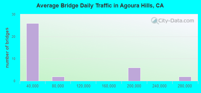
- 1,769,623Total average daily traffic
- 156,072Total average daily truck traffic
- National Bridge Inventory (NBI) Registered Bridges for Agoura Hills
- No street view available for this location
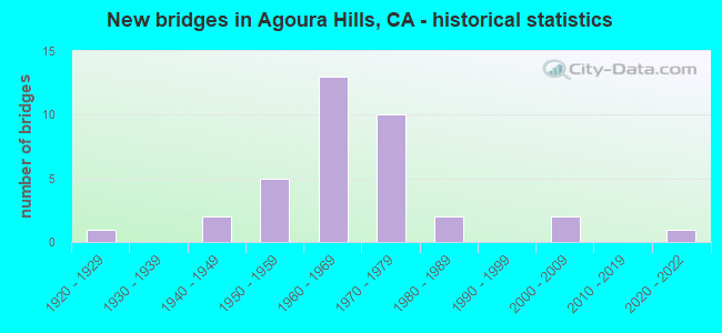
- New bridges - historical statistics
- 11920-1929
- 21940-1949
- 51950-1959
- 131960-1969
- 101970-1979
- 21980-1989
- 22000-2009
- 12020-2022
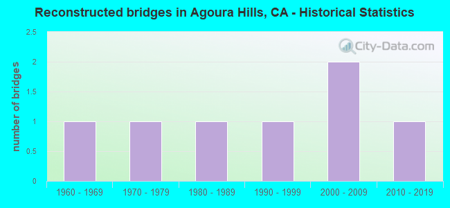
- Reconstructed bridges - Historical Statistics
- 11960-1969
- 11970-1979
- 11980-1989
- 11990-1999
- 22000-2009
- 12010-2019
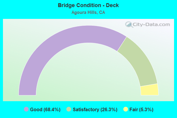
- Bridge Condition - Deck
- 68.4%Good
- 26.3%Satisfactory
- 5.3%Fair
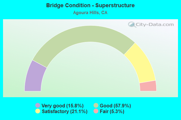
- Bridge Condition - Superstructure
- 15.8%Very good
- 57.9%Good
- 21.1%Satisfactory
- 5.3%Fair
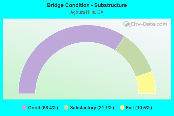
- Bridge Condition - Substructure
- 68.4%Good
- 21.1%Satisfactory
- 10.5%Fair

- Bridge Condition - Channel
- 48.1%Excellent
- 29.6%Very good
- 11.1%Good
- 7.4%Satisfactory
- 3.7%Fair
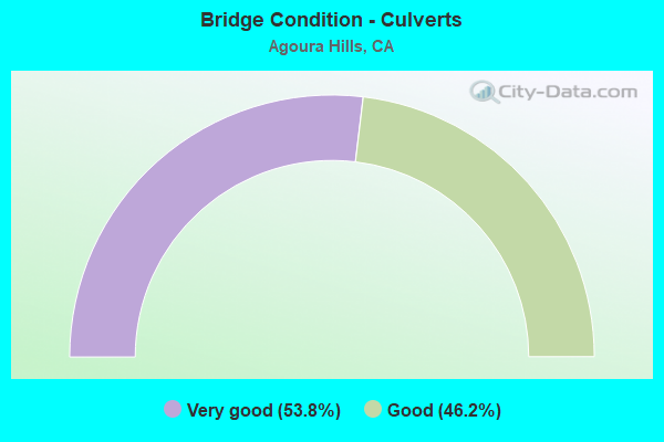
- Bridge Condition - Culverts
- 53.8%Very good
- 46.2%Good
Find on map >> Show street view
Structure Number: 53 0755, Location: 07-LA-101-33.91-AGRH (Lat: 34.143389, Lng: -118.741981), Route carried "on" structure: US 101, Year Built: 1949, Year Reconstructed: 1973, Status: Open, Structure Length: 2.44m (8.01ft), Average Daily Traffic: 160,000 (year 2018), Truck Traffic: 10%, Average Future Daily Traffic: 193,146 (year 2038), Design Load: HS 20, Features Intersected: CHESEBRO CRK
Minimum Vertical Clearance: 30+ m (98+ ft), Kilometerpoint: 33.910, Lanes on structure: 11, Base Highway Network: Yes (Inventory Route: 1, Subroute: 1), Owner: State Highway Agency, Approaching Roadway Width: 57.6m (189.0ft), Skew: 31 degrees, Material/Design: Concrete continuous, Design/Construction: Slab, Number Of Spans In Main Unit: 3, Length of Maximum Span: 7.9m (25.9ft), Curb-To-Curb Width: 57.6m (189.0ft), Out-to-Out Width: 58.2m (190.9ft)
Condition: Deck: Good, Superstructure: Good, Substructure: Good, Channel: Very good, Operating Rating: 65.1 metric tons, Method Used To Determine Operating Rating: Load Factor (LF), Inventory Rating: 39.2 metric tons, Method Used To Determine Inventory Rating: Load Factor (LF), Structural Evaluation: Better than present minimum criteria, Deck Geometry: Superior to present desirable criteria, Waterway Adequacy: Equal to present desirable criteria, Approach Roadway Alignment: Equal to present desirable criteria, Designated Inspection Frequency: Every 48 months, Inspection Date: May 2020, Deck Structure Type: Concrete Cast-file-Place, Wearing Surface/Protective System: Wearing Surface: Monolithic Concrete
Find on map >> Show street view
Structure Number: 53 0945, Location: 07-LA-101-35.04-AGRH (Lat: 34.146292, Lng: -118.761233), Route carried "on" structure: County highway W482, Year Built: 1964, Year Reconstructed: 1981, Status: Open, Structure Length: 6.07m (19.91ft), Average Daily Traffic: 20,000 (year 2018), Truck Traffic: 1%, Average Future Daily Traffic: 24,771 (year 2038), Design Load: HS 20, Features Intersected: ROUTE 101, Facility Carried by Structure: KANAN ROAD
Minimum Vertical Clearance: 30+ m (98+ ft), Kilometerpoint: 0.000, Lanes on structure: 7, Lanes under structure: 8, Base Highway Network: Yes, Owner: State Highway Agency, Approaching Roadway Width: 25.6m (84.0ft), Material/Design: Prestressed concrete continuous, Design/Construction: Stringer/Multi-beam, Number Of Spans In Main Unit: 2, Length of Maximum Span: 29.6m (97.1ft), Curb or Sidewalk Widths: Left: 1.5m (4.9ft), Right: 1.5m (4.9ft), Curb-To-Curb Width: 25.6m (84.0ft), Out-to-Out Width: 29.3m (96.1ft)
Condition: Deck: Good, Superstructure: Good, Substructure: Fair, Operating Rating: 68.0 metric tons, Method Used To Determine Operating Rating: Load Factor (LF), Inventory Rating: 32.4 metric tons, Method Used To Determine Inventory Rating: Load Factor (LF), Structural Evaluation: Somewhat better than minimum adequacy, Deck Geometry: Meets minimum limits, Underclear: Meets minimum limits, Approach Roadway Alignment: Equal to present desirable criteria, Designated Inspection Frequency: Every 24 months, Inspection Date: May 2020, Deck Structure Type: Concrete Cast-file-Place, Wearing Surface/Protective System: Wearing Surface: Monolithic Concrete
Find on map >> Show street view
Structure Number: 53 0991, Location: 07-LA-010-44.89-POM (Lat: 34.071372, Lng: -117.766508), Route carried "on" structure: Interstate 10, Year Built: 1954, Year Reconstructed: 2003, Status: Open, Structure Length: 1.22m (4.00ft), Average Daily Traffic: 247,000 (year 2012), Truck Traffic: 7%, Average Future Daily Traffic: 275,377 (year 2040), Design Load: HS 20, Features Intersected: SAN JOSE WASH
Minimum Vertical Clearance: 30+ m (98+ ft), Kilometerpoint: 44.890, Lanes on structure: 10, Base Highway Network: Yes (, Subroute: 1), Owner: State Highway Agency, Approaching Roadway Width: 48.8m (160.1ft), Skew: 36 degrees, Material/Design: Concrete, Design/Construction: Culvert, Number Of Spans In Main Unit: 1, Length of Maximum Span: 12.2m (40.0ft), Curb-To-Curb Width: 48.8m (160.1ft), Out-to-Out Width: 50.3m (165.0ft)
Condition: Channel: Very good, Culverts: Good, Operating Rating: 54.1 metric tons, Method Used To Determine Operating Rating: Field evaluation and documented engineering judgment, Inventory Rating: 32.4 metric tons, Method Used To Determine Inventory Rating: Field evaluation and documented engineering judgment, Structural Evaluation: Better than present minimum criteria, Deck Geometry: Superior to present desirable criteria, Waterway Adequacy: Equal to present desirable criteria, Approach Roadway Alignment: Equal to present desirable criteria, Designated Inspection Frequency: Every 24 months, Inspection Date: September 2021
Find on map >> Show street view
Structure Number: 53 167, Location: 07-LA-605-R13.18-SFSP (Lat: 33.987750, Lng: -118.070581), Route carried "on" structure: Interstate 605, Year Built: 1965, Status: Open, Structure Length: 4.06m (13.32ft), Average Daily Traffic: 264,000 (year 2015), Truck Traffic: 11%, Average Future Daily Traffic: 268,410 (year 2040), Design Load: HS 20, Features Intersected: BEXLEY DR
Minimum Vertical Clearance: 30+ m (98+ ft), Kilometerpoint: 13.180, Lanes on structure: 10, Lanes under structure: 2, Base Highway Network: Yes (Inventory Route: 6, Subroute: 3), Owner: State Highway Agency, Approaching Roadway Width: 41.0m (134.5ft), Skew: 32 degrees, Material/Design: Concrete continuous, Design/Construction: Box Beam or Girders - Multiple, Number Of Spans In Main Unit: 3, Length of Maximum Span: 20.4m (66.9ft), Curb-To-Curb Width: 41.0m (134.5ft), Out-to-Out Width: 42.9m (140.7ft)
Condition: Deck: Good, Superstructure: Good, Substructure: Good, Operating Rating: 67.1 metric tons, Method Used To Determine Operating Rating: Assigned rating based on Load Factor Design (LFD) reported in metric tons, Inventory Rating: 40.5 metric tons, Method Used To Determine Inventory Rating: Assigned rating based on Load Factor Design (LFD) reported in metric tons, Structural Evaluation: Better than present minimum criteria, Deck Geometry: Meets minimum limits, Underclear: Equal to present minimum criteria, Approach Roadway Alignment: Equal to present desirable criteria, Designated Inspection Frequency: Every 24 months, Inspection Date: March 2020, Deck Structure Type: Concrete Cast-file-Place
Find on map >> Show street view
Structure Number: 53 1678, Location: 07-LA-101-33.69-AGRH (Lat: 34.142892, Lng: -118.738100), Route carried "on" structure: City street , Year Built: 1963, Status: Open, Structure Length: 7.13m (23.39ft), Average Daily Traffic: 2,201 (year 2018), Truck Traffic: 1%, Average Future Daily Traffic: 2,500 (year 2038), Design Load: HS 20, Features Intersected: ROUTE 101, Facility Carried by Structure: PALO COMADO CYN RD
Minimum Vertical Clearance: 30+ m (98+ ft), Kilometerpoint: 0.000, Lanes on structure: 2, Lanes under structure: 9, Owner: State Highway Agency, Approaching Roadway Width: 12.2m (40.0ft), Material/Design: Prestressed concrete, Design/Construction: Stringer/Multi-beam, Number Of Spans In Main Unit: 2, Number Of Approach Spans: 2, Length of Maximum Span: 27.4m (89.9ft), Curb or Sidewalk Widths: Left: 1.5m (4.9ft), Right: 0.0m, Curb-To-Curb Width: 9.8m (32.2ft), Out-to-Out Width: 12.3m (40.4ft)
Condition: Deck: Good, Superstructure: Good, Substructure: Good, Operating Rating: 43.7 metric tons, Method Used To Determine Operating Rating: Load and Resistance Factor Rating (LRFR) rating reported by rating factor(RF) method using HL-93 loadings, Inventory Rating: 25.9 metric tons, Method Used To Determine Inventory Rating: Load and Resistance Factor Rating (LRFR) rating reported by rating factor(RF) method using HL-93 loadings, Structural Evaluation: Equal to present minimum criteria, Deck Geometry: Meets minimum limits, Underclear: High priority of corrective action, Approach Roadway Alignment: Equal to present desirable criteria, Designated Inspection Frequency: Every 24 months, Inspection Date: May 2020, Deck Structure Type: Concrete Cast-file-Place
Find on map >> Show street view
Structure Number: 53 1726, Location: 07-LA-101-36.18-AGRH (Lat: 34.146614, Lng: -118.780997), Route carried "on" structure: City street N095, Year Built: 1965, Year Reconstructed: 2011, Status: Open, Structure Length: 6.74m (22.11ft), Average Daily Traffic: 5,500 (year 2018), Truck Traffic: 1%, Average Future Daily Traffic: 6,500 (year 2038), Design Load: HS 20, Features Intersected: US 101, Facility Carried by Structure: REYES ADOBE RD
Minimum Vertical Clearance: 30+ m (98+ ft), Kilometerpoint: 0.000, Lanes on structure: 3, Lanes under structure: 8, Owner: State Highway Agency, Approaching Roadway Width: 12.2m (40.0ft), Material/Design: Prestressed concrete, Design/Construction: Stringer/Multi-beam, Number Of Spans In Main Unit: 4, Number Of Approach Spans: 2, Length of Maximum Span: 23.8m (78.1ft), Curb or Sidewalk Widths: Left: 0.0m, Right: 1.5m (4.9ft), Curb-To-Curb Width: 9.8m (32.2ft), Out-to-Out Width: 12.1m (39.7ft)
Condition: Deck: Good, Superstructure: Good, Substructure: Good, Operating Rating: 36.3 metric tons, Method Used To Determine Operating Rating: Load and Resistance Factor Rating (LRFR) rating reported by rating factor(RF) method using HL-93 loadings, Inventory Rating: 22.4 metric tons, Method Used To Determine Inventory Rating: Load and Resistance Factor Rating (LRFR) rating reported by rating factor(RF) method using HL-93 loadings, Structural Evaluation: Somewhat better than minimum adequacy, Deck Geometry: High priority of replacement, Underclear: Meets minimum limits, Approach Roadway Alignment: Superior to present desirable criteria, Designated Inspection Frequency: Every 24 months, Inspection Date: May 2020, Deck Structure Type: Concrete Cast-file-Place, Wearing Surface/Protective System: Wearing Surface: Monolithic Concrete
Find on map >> Show street view
Structure Number: 53 1731, Location: 07-LA-101-32.78 (Lat: 34.138372, Lng: -118.724317), Route carried "on" structure: US 101, Year Built: 1973, Status: Open, Structure Length: 4.60m (15.09ft), Average Daily Traffic: 167,000 (year 2018), Truck Traffic: 10%, Average Future Daily Traffic: 200,129 (year 2040), Design Load: HS 20, Features Intersected: LIBERTY CANYON RD
Minimum Vertical Clearance: 30+ m (98+ ft), Kilometerpoint: 32.780, Lanes on structure: 8, Lanes under structure: 2, Base Highway Network: Yes (Inventory Route: 1, Subroute: 1), Owner: State Highway Agency, Approaching Roadway Width: 41.5m (136.2ft), Skew: 30 degrees, Material/Design: Prestressed concrete, Design/Construction: Box Beam or Girders - Multiple, Number Of Spans In Main Unit: 1, Length of Maximum Span: 45.4m (149.0ft), Curb-To-Curb Width: 41.5m (136.2ft), Out-to-Out Width: 42.7m (140.1ft)
Condition: Deck: Good, Superstructure: Good, Substructure: Good, Operating Rating: 45.4 metric tons, Method Used To Determine Operating Rating: Load and Resistance Factor Rating (LRFR) rating reported by rating factor(RF) method using HL-93 loadings, Inventory Rating: 29.8 metric tons, Method Used To Determine Inventory Rating: Load and Resistance Factor Rating (LRFR) rating reported by rating factor(RF) method using HL-93 loadings, Structural Evaluation: Better than present minimum criteria, Deck Geometry: Superior to present desirable criteria, Underclear: Better than present minimum criteria, Approach Roadway Alignment: Equal to present desirable criteria, Designated Inspection Frequency: Every 24 months, Inspection Date: May 2020, Deck Structure Type: Concrete Cast-file-Place
Find on map >> Show street view
Structure Number: 53C0285, Location: 0.3MI E/O KANAN RD (Lat: 34.145900, Lng: -118.757769), Route carried "on" structure: City street 7N11, Year Built: 1964, Year Reconstructed: 2005, Status: Open, Structure Length: 3.23m (10.60ft), Average Daily Traffic: 8,755 (year 2012), Truck Traffic: 2%, Average Future Daily Traffic: 10,068 (year 2040), Design Load: HS 20+Mod, Features Intersected: MEDEA CRK, Facility Carried by Structure: CANWOOD ST
Minimum Vertical Clearance: 30.47m (99.97ft), Kilometerpoint: 0.000, Lanes on structure: 2, Owner: City or Municipal Highway Agency, Approaching Roadway Width: 13.7m (44.9ft), Material/Design: Concrete continuous, Design/Construction: Slab, Number Of Spans In Main Unit: 4, Length of Maximum Span: 7.9m (25.9ft), Curb or Sidewalk Widths: Left: 1.5m (4.9ft), Right: 0.6m (2.0ft), Curb-To-Curb Width: 13.7m (44.9ft), Out-to-Out Width: 16.6m (54.5ft)
Condition: Deck: Satisfactory, Superstructure: Satisfactory, Substructure: Good, Channel: Very good, Operating Rating: 57.7 metric tons, Method Used To Determine Operating Rating: Load Factor (LF), Inventory Rating: 34.7 metric tons, Method Used To Determine Inventory Rating: Load Factor (LF), Structural Evaluation: Equal to present minimum criteria, Deck Geometry: Superior to present desirable criteria, Waterway Adequacy: Better than present minimum criteria, Approach Roadway Alignment: Better than present minimum criteria, Designated Inspection Frequency: Every 48 months, Inspection Date: April 2020, Deck Structure Type: Concrete Cast-file-Place, Wearing Surface/Protective System: Wearing Surface: Monolithic Concrete
Find on map >> Show street view
Structure Number: 53C0613, Location: 0.5MI W/O KANAN RD (Lat: 34.123172, Lng: -118.794167), Route carried "on" structure: County highway N046, Year Built: 1951, Status: Open, Structure Length: 1.55m (5.09ft), Average Daily Traffic: 1,734 (year 2012), Truck Traffic: 1%, Average Future Daily Traffic: 1,907 (year 2042), Design Load: HS 20, Features Intersected: LOBO CRK, Facility Carried by Structure: TRIUNFO CYN RD
Minimum Vertical Clearance: 30.47m (99.97ft), Kilometerpoint: 0.000, Lanes on structure: 2, Owner: County Highway Agency, Approaching Roadway Width: 7.9m (25.9ft), Skew: 3 degrees, Material/Design: Wood or Timber, Design/Construction: Slab, Number Of Spans In Main Unit: 2, Length of Maximum Span: 7.6m (24.9ft), Curb-To-Curb Width: 8.2m (26.9ft), Out-to-Out Width: 8.4m (27.6ft)
Condition: Deck: Good, Superstructure: Good, Substructure: Good, Channel: Satisfactory, Operating Rating: 56.4 metric tons, Method Used To Determine Operating Rating: Allowable Stress (AS), Inventory Rating: 39.9 metric tons, Method Used To Determine Inventory Rating: Allowable Stress (AS), Structural Evaluation: Better than present minimum criteria, Deck Geometry: Meets minimum limits, Waterway Adequacy: Equal to present minimum criteria, Approach Roadway Alignment: Equal to present desirable criteria, Designated Inspection Frequency: Every 48 months, Inspection Date: November 2020, Deck Structure Type: Wood or Timber, Wearing Surface/Protective System: Wearing Surface: Bituminous
Find on map >> Show street view
Structure Number: 53C0627, Location: 2.0MI S/O US-101 FWY (Lat: 34.110703, Lng: -118.756133), Route carried "on" structure: County highway L722, Year Built: 1955, Status: Open, Structure Length: 9.72m (31.89ft), Average Daily Traffic: 816 (year 2012), Truck Traffic: 1%, Average Future Daily Traffic: 898 (year 2040), Design Load: HS 20, Features Intersected: MEDEA CR, Facility Carried by Structure: MULHOLLAND HWY
Minimum Vertical Clearance: 30.47m (99.97ft), Kilometerpoint: 0.000, Lanes on structure: 2, Owner: County Highway Agency, Approaching Roadway Width: 7.9m (25.9ft), Material/Design: Steel, Design/Construction: Stringer/Multi-beam, Number Of Spans In Main Unit: 4, Length of Maximum Span: 24.1m (79.1ft), Curb or Sidewalk Widths: Left: 0.0m, Right: 0.8m (2.6ft), Curb-To-Curb Width: 7.9m (25.9ft), Out-to-Out Width: 8.3m (27.2ft)
Condition: Deck: Satisfactory, Superstructure: Satisfactory, Substructure: Satisfactory, Channel: Good, Operating Rating: 87.2 metric tons, Method Used To Determine Operating Rating: Load Factor (LF), Inventory Rating: 52.2 metric tons, Method Used To Determine Inventory Rating: Load Factor (LF), Structural Evaluation: Equal to present minimum criteria, Deck Geometry: Somewhat better than minimum adequacy, Waterway Adequacy: Superior to present desirable criteria, Approach Roadway Alignment: Equal to present desirable criteria, Designated Inspection Frequency: Every 24 months, Underwater Inspection Frequency: Every 60 months, Inspection Date: December 2020, Underwater Inspection Date: March 2021, Deck Structure Type: Concrete Cast-file-Place, Wearing Surface/Protective System: Wearing Surface: Monolithic Concrete
Find on map >> Show street view
Structure Number: 53C0775, Location: 3.0MI S/O US-101 FWY (Lat: 34.119161, Lng: -118.781003), Route carried "on" structure: County highway W482, Year Built: 1962, Year Reconstructed: 1994, Status: Open, Structure Length: 1.98m (6.50ft), Average Daily Traffic: 6,592 (year 2012), Truck Traffic: 1%, Average Future Daily Traffic: 7,581 (year 2040), Design Load: HS 20, Features Intersected: TRIUNFO CR, Facility Carried by Structure: KANAN RD
Minimum Vertical Clearance: 30.47m (99.97ft), Kilometerpoint: 0.000, Lanes on structure: 2, Owner: County Highway Agency, Approaching Roadway Width: 8.4m (27.6ft), Material/Design: Concrete, Design/Construction: Tee Beam, Number Of Spans In Main Unit: 1, Length of Maximum Span: 19.5m (64.0ft), Curb or Sidewalk Widths: Left: 0.5m (1.6ft), Right: 0.5m (1.6ft), Curb-To-Curb Width: 12.0m (39.4ft), Out-to-Out Width: 13.2m (43.3ft)
Condition: Deck: Good, Superstructure: Good, Substructure: Good, Channel: Very good, Operating Rating: 54.1 metric tons, Method Used To Determine Operating Rating: Assigned rating based on Load Factor Design (LFD) reported in metric tons, Inventory Rating: 32.4 metric tons, Method Used To Determine Inventory Rating: Assigned rating based on Load Factor Design (LFD) reported in metric tons, Structural Evaluation: Better than present minimum criteria, Deck Geometry: Somewhat better than minimum adequacy, Waterway Adequacy: Superior to present desirable criteria, Approach Roadway Alignment: Equal to present desirable criteria, Designated Inspection Frequency: Every 48 months, Inspection Date: November 2020, Deck Structure Type: Concrete Cast-file-Place, Wearing Surface/Protective System: Wearing Surface: Monolithic Concrete
Find on map >> Show street view
Structure Number: 53C0839, Location: 0.4MI N/O US-101 FWY (Lat: 34.150711, Lng: -118.758550), Route carried "on" structure: City street 7W48, Year Built: 1971, Status: Open, Structure Length: 1.28m (4.20ft), Average Daily Traffic: 44,084 (year 2012), Truck Traffic: 2%, Average Future Daily Traffic: 52,901 (year 2040), Features Intersected: MEDEA CRK, Facility Carried by Structure: KANAN RD
Minimum Vertical Clearance: 30.47m (99.97ft), Kilometerpoint: 0.000, Lanes on structure: 4, Owner: City or Municipal Highway Agency, Approaching Roadway Width: 25.9m (85.0ft), Skew: 22 degrees, Material/Design: Concrete, Design/Construction: Culvert, Number Of Spans In Main Unit: 3, Length of Maximum Span: 4.3m (14.1ft), Curb or Sidewalk Widths: Left: 1.5m (4.9ft), Right: 1.5m (4.9ft)
Condition: Channel: Excellent, Culverts: Good, Operating Rating: 40.5 metric tons, Method Used To Determine Operating Rating: Field evaluation and documented engineering judgment, Inventory Rating: 24.3 metric tons, Method Used To Determine Inventory Rating: Field evaluation and documented engineering judgment, Structural Evaluation: Equal to present minimum criteria, Waterway Adequacy: Superior to present desirable criteria, Approach Roadway Alignment: Equal to present desirable criteria, Designated Inspection Frequency: Every 24 months, Inspection Date: April 2020
Find on map >> Show street view
Structure Number: 53C0847, Location: 200FT S/O US-101 FWY (Lat: 34.136156, Lng: -118.726319), Route carried "on" structure: City street 7N04, Year Built: 1971, Status: Open, Structure Length: 0.73m (2.40ft), Average Daily Traffic: 1,224 (year 2012), Truck Traffic: 2%, Average Future Daily Traffic: 1,346 (year 2040), Features Intersected: PRIVATE DRN #571, Facility Carried by Structure: AGOURA RD
Minimum Vertical Clearance: 30.47m (99.97ft), Kilometerpoint: 0.000, Lanes on structure: 2, Owner: City or Municipal Highway Agency, Approaching Roadway Width: 7.3m (24.0ft), Skew: 6 degrees, Material/Design: Concrete, Design/Construction: Culvert, Number Of Spans In Main Unit: 2, Length of Maximum Span: 3.4m (11.2ft), Curb or Sidewalk Widths: Left: 0.0m, Right: 2.4m (7.9ft)
Condition: Channel: Very good, Culverts: Very good, Operating Rating: 40.5 metric tons, Method Used To Determine Operating Rating: Field evaluation and documented engineering judgment, Inventory Rating: 24.3 metric tons, Method Used To Determine Inventory Rating: Field evaluation and documented engineering judgment, Structural Evaluation: Equal to present minimum criteria, Waterway Adequacy: Equal to present desirable criteria, Approach Roadway Alignment: Equal to present minimum criteria, Designated Inspection Frequency: Every 24 months, Inspection Date: April 2020
Find on map >> Show street view
Structure Number: 53C0848, Location: 300FT W/O CHESEBORO RD (Lat: 34.145631, Lng: -118.740056), Route carried "on" structure: City street , Year Built: 1972, Status: Open, Structure Length: 1.04m (3.41ft), Average Daily Traffic: 3,927 (year 2012), Average Future Daily Traffic: 4,320 (year 2040), Features Intersected: CHESEBORO CYN CRK, Facility Carried by Structure: DRIVER AVE
Minimum Vertical Clearance: 30.47m (99.97ft), Kilometerpoint: 0.000, Lanes on structure: 2, Owner: City or Municipal Highway Agency, Approaching Roadway Width: 8.4m (27.6ft), Material/Design: Concrete, Design/Construction: Culvert, Number Of Spans In Main Unit: 1, Length of Maximum Span: 9.4m (30.8ft), Curb or Sidewalk Widths: Left: 1.5m (4.9ft), Right: 1.5m (4.9ft), Curb-To-Curb Width: 8.6m (28.2ft), Out-to-Out Width: 12.1m (39.7ft)
Condition: Channel: Excellent, Culverts: Very good, Operating Rating: 40.5 metric tons, Method Used To Determine Operating Rating: Field evaluation and documented engineering judgment, Inventory Rating: 24.3 metric tons, Method Used To Determine Inventory Rating: Field evaluation and documented engineering judgment, Structural Evaluation: Equal to present minimum criteria, Deck Geometry: Meets minimum limits, Waterway Adequacy: Better than present minimum criteria, Approach Roadway Alignment: Equal to present minimum criteria, Designated Inspection Frequency: Every 24 months, Inspection Date: April 2020
Find on map >> Show street view
Structure Number: 53C0849, Location: 50FT N/O AGOURA RD (Lat: 34.143575, Lng: -118.756047), Route carried "on" structure: City street 7N04, Year Built: 1973, Status: Open, Structure Length: 0.82m (2.69ft), Average Daily Traffic: 5,459 (year 2012), Truck Traffic: 2%, Average Future Daily Traffic: 6,278 (year 2040), Features Intersected: CHESEBORO CYN CRK, Facility Carried by Structure: AGOURA/CORNELL RDS
Minimum Vertical Clearance: 30.47m (99.97ft), Kilometerpoint: 0.000, Lanes on structure: 2, Owner: City or Municipal Highway Agency, Approaching Roadway Width: 10.7m (35.1ft), Material/Design: Concrete, Design/Construction: Culvert, Number Of Spans In Main Unit: 1, Length of Maximum Span: 7.6m (24.9ft), Curb or Sidewalk Widths: Left: 3.1m (10.2ft), Right: 0.0m, Curb-To-Curb Width: 11.1m (36.4ft), Out-to-Out Width: 19.0m (62.3ft)
Condition: Channel: Excellent, Culverts: Good, Operating Rating: 54.1 metric tons, Method Used To Determine Operating Rating: Field evaluation and documented engineering judgment, Inventory Rating: 32.4 metric tons, Method Used To Determine Inventory Rating: Field evaluation and documented engineering judgment, Structural Evaluation: Better than present minimum criteria, Deck Geometry: Meets minimum limits, Waterway Adequacy: Equal to present desirable criteria, Approach Roadway Alignment: Superior to present desirable criteria, Designated Inspection Frequency: Every 48 months, Inspection Date: April 2020
Find on map >> Show street view
Structure Number: 53C0862, Location: 0.2MI W/O KANAN RD (Lat: 34.143281, Lng: -118.764161), Route carried "on" structure: City street 7N04, Year Built: 1972, Status: Open, Structure Length: 0.76m (2.49ft), Average Daily Traffic: 8,910 (year 2012), Truck Traffic: 2%, Average Future Daily Traffic: 10,246 (year 2040), Features Intersected: LINDERO CYN CHAN, Facility Carried by Structure: AGOURA RD
Minimum Vertical Clearance: 30.47m (99.97ft), Kilometerpoint: 0.000, Lanes on structure: 4, Owner: City or Municipal Highway Agency, Approaching Roadway Width: 7.9m (25.9ft), Skew: 2 degrees, Material/Design: Concrete, Design/Construction: Culvert, Number Of Spans In Main Unit: 1, Length of Maximum Span: 6.1m (20.0ft)
Condition: Channel: Excellent, Culverts: Very good, Operating Rating: 40.5 metric tons, Method Used To Determine Operating Rating: Field evaluation and documented engineering judgment, Inventory Rating: 24.3 metric tons, Method Used To Determine Inventory Rating: Field evaluation and documented engineering judgment, Structural Evaluation: Equal to present minimum criteria, Waterway Adequacy: Better than present minimum criteria, Approach Roadway Alignment: Equal to present desirable criteria, Designated Inspection Frequency: Every 24 months, Inspection Date: April 2020
Find on map >> Show street view
Structure Number: 53C0891, Location: 0.3MI E/O LINDERO CYN RD (Lat: 34.154692, Lng: -118.791236), Route carried "on" structure: City street 7N02, Year Built: 1975, Status: Open, Structure Length: 1.04m (3.41ft), Average Daily Traffic: 13,287 (year 2012), Truck Traffic: 1%, Average Future Daily Traffic: 15,280 (year 2040), Design Load: HS 20, Features Intersected: LINDERO CYN CHAN, Facility Carried by Structure: THOUSAND OAKS BLVD
Minimum Vertical Clearance: 30.47m (99.97ft), Kilometerpoint: 0.000, Lanes on structure: 4, Owner: City or Municipal Highway Agency, Approaching Roadway Width: 25.6m (84.0ft), Skew: 20 degrees, Material/Design: Concrete, Design/Construction: Culvert, Number Of Spans In Main Unit: 2, Length of Maximum Span: 4.9m (16.1ft), Curb or Sidewalk Widths: Left: 2.5m (8.2ft), Right: 2.4m (7.9ft)
Condition: Channel: Good, Culverts: Very good, Operating Rating: 54.1 metric tons, Method Used To Determine Operating Rating: Field evaluation and documented engineering judgment, Inventory Rating: 32.4 metric tons, Method Used To Determine Inventory Rating: Field evaluation and documented engineering judgment, Structural Evaluation: Equal to present desirable criteria, Waterway Adequacy: Equal to present minimum criteria, Approach Roadway Alignment: Equal to present desirable criteria, Designated Inspection Frequency: Every 48 months, Inspection Date: April 2020
Find on map >> Show street view
Structure Number: 53C0998, Location: 0.6MI N/O US-101 FWY (Lat: 34.151314, Lng: -118.734472), Route carried "on" structure: County highway N113, Year Built: 1943, Year Reconstructed: 2019, Status: Open, Structure Length: 2.37m (7.78ft), Average Daily Traffic: 1,479 (year 2012), Truck Traffic: 2%, Average Future Daily Traffic: 1,627 (year 2041), Features Intersected: CHESEBRO CYN CRK, Facility Carried by Structure: CHESEBRO RD
Minimum Vertical Clearance: 30.47m (99.97ft), Kilometerpoint: 0.000, Lanes on structure: 1, Owner: County Highway Agency, Approaching Roadway Width: 5.5m (18.0ft), Skew: 5 degrees, Material/Design: Steel, Number Of Spans In Main Unit: 1, Length of Maximum Span: 23.4m (76.8ft), Curb-To-Curb Width: 3.8m (12.5ft), Out-to-Out Width: 4.0m (13.1ft)
Condition: Deck: Good, Superstructure: Good, Substructure: Good, Channel: Very good, Operating Rating: 54.1 metric tons, Method Used To Determine Operating Rating: Field evaluation and documented engineering judgment, Inventory Rating: 32.4 metric tons, Method Used To Determine Inventory Rating: Field evaluation and documented engineering judgment, Structural Evaluation: Better than present minimum criteria, Deck Geometry: High priority of replacement, Waterway Adequacy: Equal to present minimum criteria, Approach Roadway Alignment: Better than present minimum criteria, Designated Inspection Frequency: Every 24 months, Inspection Date: October 2021, Deck Structure Type: Steel plate, Wearing Surface/Protective System: Wearing Surface: Bituminous
Find on map >> Show street view
Structure Number: 53C1004, Location: 0.3MI S/O MULHOLLAND HWY (Lat: 34.105511, Lng: -118.764328), Route carried "on" structure: County highway , Year Built: 1951, Status: Open, Structure Length: 5.00m (16.40ft), Average Daily Traffic: 1,020 (year 2012), Truck Traffic: 1%, Average Future Daily Traffic: 1,122 (year 2038), Design Load: HS 20, Features Intersected: TRIUNFO CRK, Facility Carried by Structure: CRAGS DR
Minimum Vertical Clearance: 30.47m (99.97ft), Kilometerpoint: 0.000, Lanes on structure: 2, Owner: County Highway Agency, Approaching Roadway Width: 7.3m (24.0ft), Material/Design: Concrete continuous, Design/Construction: Tee Beam, Number Of Spans In Main Unit: 3, Length of Maximum Span: 20.1m (65.9ft), Curb-To-Curb Width: 8.0m (26.2ft), Out-to-Out Width: 8.3m (27.2ft)
Condition: Deck: Good, Superstructure: Good, Substructure: Satisfactory, Channel: Satisfactory, Operating Rating: 56.1 metric tons, Method Used To Determine Operating Rating: Load Factor (LF), Inventory Rating: 33.4 metric tons, Method Used To Determine Inventory Rating: Load Factor (LF), Structural Evaluation: Equal to present minimum criteria, Deck Geometry: Meets minimum limits, Waterway Adequacy: Equal to present desirable criteria, Approach Roadway Alignment: Better than present minimum criteria, Designated Inspection Frequency: Every 48 months, Underwater Inspection Frequency: Every 60 months, Inspection Date: December 2018, Underwater Inspection Date: March 2021, Deck Structure Type: Concrete Cast-file-Place, Wearing Surface/Protective System: Wearing Surface: Monolithic Concrete
Find on map >> Show street view
Structure Number: 53C148, Location: 0.1MI E/O B ST (Lat: 34.105336, Lng: -117.772711), Route carried "on" structure: City street , Year Built: 1964, Status: Open, Structure Length: 0.79m (2.59ft), Average Daily Traffic: 51 (year 2012), Truck Traffic: 1%, Average Future Daily Traffic: 51 (year 2041), Design Load: HS 20, Features Intersected: EMERALD WASH, Facility Carried by Structure: 7TH ST
Minimum Vertical Clearance: 30+ m (98+ ft), Kilometerpoint: 0.000, Lanes on structure: 2, Owner: City or Municipal Highway Agency, Approaching Roadway Width: 8.5m (27.9ft), Material/Design: Concrete, Design/Construction: Culvert, Number Of Spans In Main Unit: 1, Length of Maximum Span: 7.3m (24.0ft), Curb or Sidewalk Widths: Left: 0.4m (1.3ft), Right: 1.3m (4.3ft), Curb-To-Curb Width: 8.4m (27.6ft), Out-to-Out Width: 11.0m (36.1ft)
Condition: Channel: Excellent, Culverts: Good, Operating Rating: 45.7 metric tons, Method Used To Determine Operating Rating: Load Factor (LF), Inventory Rating: 27.5 metric tons, Method Used To Determine Inventory Rating: Load Factor (LF), Structural Evaluation: Equal to present minimum criteria, Deck Geometry: Equal to present minimum criteria, Waterway Adequacy: Superior to present desirable criteria, Approach Roadway Alignment: Equal to present desirable criteria, Designated Inspection Frequency: Every 24 months, Inspection Date: October 2021, Deck Structure Type: Concrete Cast-file-Place
Find on map >> Show street view
Structure Number: 53C1489L, Location: 1.0MI E/O LINDERO CYN RD (Lat: 34.147728, Lng: -118.787228), Route carried "on" structure: City street , Year Built: 1965, Status: Open, Structure Length: 1.52m (4.99ft), Average Daily Traffic: 2,142 (year 2012), Truck Traffic: 2%, Average Future Daily Traffic: 2,356 (year 2040), Design Load: HS 20, Features Intersected: LAKE LINDERO CRK, Facility Carried by Structure: LAKE LINDERO DR S
Minimum Vertical Clearance: 30.47m (99.97ft), Kilometerpoint: 0.000, Lanes on structure: 1, Owner: City or Municipal Highway Agency, Approaching Roadway Width: 6.1m (20.0ft), Skew: 9 degrees, Material/Design: Prestressed concrete, Design/Construction: Box Beam or Girders - Multiple, Number Of Spans In Main Unit: 1, Length of Maximum Span: 14.6m (47.9ft), Curb or Sidewalk Widths: Left: 1.3m (4.3ft), Right: 0.0m, Curb-To-Curb Width: 6.0m (19.7ft), Out-to-Out Width: 8.6m (28.2ft)
Condition: Deck: Good, Superstructure: Very good, Substructure: Satisfactory, Channel: Excellent, Operating Rating: 66.7 metric tons, Method Used To Determine Operating Rating: Load Factor (LF), Inventory Rating: 39.9 metric tons, Method Used To Determine Inventory Rating: Load Factor (LF), Structural Evaluation: Equal to present minimum criteria, Deck Geometry: High priority of replacement, Waterway Adequacy: Superior to present desirable criteria, Approach Roadway Alignment: Equal to present minimum criteria, Designated Inspection Frequency: Every 48 months, Inspection Date: April 2020, Deck Structure Type: Concrete Cast-file-Place, Wearing Surface/Protective System: Wearing Surface: Bituminous
Find on map >> Show street view
Structure Number: 53C1489R, Location: 1.0MI E/O LINDERO CN RD (Lat: 34.147722, Lng: -118.787078), Route carried "on" structure: City street , Year Built: 1965, Status: Open, Structure Length: 1.52m (4.99ft), Average Daily Traffic: 2,142 (year 2012), Truck Traffic: 2%, Average Future Daily Traffic: 2,356 (year 2040), Design Load: HS 20, Features Intersected: LAKE LINDERO CRK, Facility Carried by Structure: LAKE LINDERO DR N
Minimum Vertical Clearance: 30.47m (99.97ft), Kilometerpoint: 0.000, Lanes on structure: 1, Owner: City or Municipal Highway Agency, Approaching Roadway Width: 6.1m (20.0ft), Skew: 9 degrees, Material/Design: Prestressed concrete, Design/Construction: Box Beam or Girders - Multiple, Number Of Spans In Main Unit: 1, Length of Maximum Span: 14.6m (47.9ft), Curb or Sidewalk Widths: Left: 0.0m, Right: 1.4m (4.6ft), Curb-To-Curb Width: 5.9m (19.4ft), Out-to-Out Width: 8.6m (28.2ft)
Condition: Deck: Good, Superstructure: Very good, Substructure: Satisfactory, Channel: Excellent, Operating Rating: 66.7 metric tons, Method Used To Determine Operating Rating: Load Factor (LF), Inventory Rating: 39.9 metric tons, Method Used To Determine Inventory Rating: Load Factor (LF), Structural Evaluation: Equal to present minimum criteria, Deck Geometry: High priority of replacement, Waterway Adequacy: Superior to present desirable criteria, Approach Roadway Alignment: Equal to present minimum criteria, Designated Inspection Frequency: Every 48 months, Inspection Date: April 2020, Deck Structure Type: Concrete Cast-file-Place, Wearing Surface/Protective System: Wearing Surface: Bituminous
Find on map >> Show street view
Structure Number: 53C153, Location: 0.1MI S/O AMAR RD (Lat: 34.034008, Lng: -117.934706), Route carried "on" structure: County highway , Year Built: 1970, Status: Open, Structure Length: 0.98m (3.22ft), Average Daily Traffic: 5,345 (year 2012), Truck Traffic: 2%, Average Future Daily Traffic: 6,147 (year 2040), Features Intersected: PUENTE CRK, Facility Carried by Structure: ECHELON AVE
Minimum Vertical Clearance: 30.47m (99.97ft), Kilometerpoint: 0.000, Lanes on structure: 2, Owner: County Highway Agency, Approaching Roadway Width: 11.0m (36.1ft), Material/Design: Concrete, Design/Construction: Slab, Number Of Spans In Main Unit: 1, Length of Maximum Span: 9.1m (29.9ft), Curb or Sidewalk Widths: Left: 1.4m (4.6ft), Right: 3.4m (11.2ft), Curb-To-Curb Width: 10.9m (35.8ft), Out-to-Out Width: 16.3m (53.5ft)
Condition: Deck: Satisfactory, Superstructure: Satisfactory, Substructure: Good, Channel: Excellent, Operating Rating: 58.3 metric tons, Method Used To Determine Operating Rating: Load Factor (LF), Inventory Rating: 35.0 metric tons, Method Used To Determine Inventory Rating: Load Factor (LF), Structural Evaluation: Equal to present minimum criteria, Deck Geometry: Meets minimum limits, Waterway Adequacy: Superior to present desirable criteria, Approach Roadway Alignment: Better than present minimum criteria, Designated Inspection Frequency: Every 48 months, Inspection Date: October 2020, Deck Structure Type: Concrete Cast-file-Place, Wearing Surface/Protective System: Wearing Surface: Bituminous
Find on map >> Show street view
Structure Number: 53C1534, Location: 0.2MI S/O US-101 FWY (Lat: 34.133500, Lng: -118.723958), Route carried "on" structure: City street , Year Built: 1971, Status: Open, Structure Length: 0.82m (2.69ft), Average Daily Traffic: 4,896 (year 2012), Truck Traffic: 2%, Average Future Daily Traffic: 5,386 (year 2040), Features Intersected: PRIVATE DRN #571, Facility Carried by Structure: LIBERTY CYN RD
Minimum Vertical Clearance: 30.47m (99.97ft), Kilometerpoint: 0.000, Lanes on structure: 3, Owner: City or Municipal Highway Agency, Approaching Roadway Width: 19.5m (64.0ft), Skew: 23 degrees, Material/Design: Concrete, Design/Construction: Culvert, Number Of Spans In Main Unit: 2, Length of Maximum Span: 3.4m (11.2ft), Curb or Sidewalk Widths: Left: 2.5m (8.2ft), Right: 0.0m
Condition: Channel: Excellent, Culverts: Good, Operating Rating: 40.5 metric tons, Method Used To Determine Operating Rating: Field evaluation and documented engineering judgment, Inventory Rating: 24.3 metric tons, Method Used To Determine Inventory Rating: Field evaluation and documented engineering judgment, Structural Evaluation: Equal to present minimum criteria, Waterway Adequacy: Superior to present desirable criteria, Approach Roadway Alignment: Equal to present desirable criteria, Designated Inspection Frequency: Every 24 months, Inspection Date: April 2020
Find on map >> Show street view
Structure Number: 53C1539, Location: 0.1MI S/O US-101 FWY (Lat: 34.141739, Lng: -118.742792), Route carried "on" structure: City street , Year Built: 1970, Status: Open, Structure Length: 0.98m (3.22ft), Average Daily Traffic: 2,754 (year 2012), Truck Traffic: 1%, Average Future Daily Traffic: 3,029 (year 2040), Features Intersected: CHESEBORO CYN CRK, Facility Carried by Structure: LEWIS RD
Minimum Vertical Clearance: 30.47m (99.97ft), Kilometerpoint: 0.000, Lanes on structure: 2, Owner: City or Municipal Highway Agency, Approaching Roadway Width: 11.3m (37.1ft), Skew: 9 degrees, Material/Design: Concrete, Design/Construction: Culvert, Number Of Spans In Main Unit: 2, Length of Maximum Span: 4.6m (15.1ft), Curb or Sidewalk Widths: Left: 1.5m (4.9ft), Right: 2.7m (8.9ft)
Condition: Channel: Excellent, Culverts: Very good, Operating Rating: 40.5 metric tons, Method Used To Determine Operating Rating: Field evaluation and documented engineering judgment, Inventory Rating: 24.3 metric tons, Method Used To Determine Inventory Rating: Field evaluation and documented engineering judgment, Structural Evaluation: Equal to present minimum criteria, Waterway Adequacy: Equal to present desirable criteria, Approach Roadway Alignment: Equal to present minimum criteria, Designated Inspection Frequency: Every 24 months, Inspection Date: April 2020
Find on map >> Show street view
Structure Number: 53C1724, Location: 0.3MI W/O KANAN RD (Lat: 34.166300, Lng: -118.762183), Route carried "on" structure: City street , Year Built: 1981, Status: Open, Structure Length: 1.70m (5.58ft), Average Daily Traffic: 102 (year 2012), Average Future Daily Traffic: 102 (year 2040), Design Load: HS 20, Features Intersected: MEDEA CRK, Facility Carried by Structure: FOUNTAINWOOD ST
Minimum Vertical Clearance: 30.47m (99.97ft), Kilometerpoint: 0.000, Lanes on structure: 2, Owner: City or Municipal Highway Agency, Approaching Roadway Width: 12.2m (40.0ft), Material/Design: Concrete, Design/Construction: Culvert, Number Of Spans In Main Unit: 2, Length of Maximum Span: 6.1m (20.0ft), Curb or Sidewalk Widths: Left: 1.9m (6.2ft), Right: 1.9m (6.2ft), Curb-To-Curb Width: 12.0m (39.4ft), Out-to-Out Width: 16.5m (54.1ft)
Condition: Channel: Excellent, Culverts: Very good, Operating Rating: 54.1 metric tons, Method Used To Determine Operating Rating: Field evaluation and documented engineering judgment, Inventory Rating: 32.4 metric tons, Method Used To Determine Inventory Rating: Field evaluation and documented engineering judgment, Structural Evaluation: Equal to present desirable criteria, Deck Geometry: Superior to present desirable criteria, Waterway Adequacy: Superior to present desirable criteria, Approach Roadway Alignment: Equal to present minimum criteria, Designated Inspection Frequency: Every 48 months, Inspection Date: April 2020
Find on map >> Show street view
Structure Number: 53C1852, Location: 1.0MI N/O US-101 FWY (Lat: 34.159653, Lng: -118.760706), Route carried "on" structure: City street , Year Built: 1981, Status: Open, Structure Length: 1.31m (4.30ft), Average Daily Traffic: 2,040 (year 2012), Average Future Daily Traffic: 2,244 (year 2040), Design Load: HS 20, Features Intersected: MEDEA CRK, Facility Carried by Structure: LARO DR
Minimum Vertical Clearance: 30.47m (99.97ft), Kilometerpoint: 0.000, Lanes on structure: 2, Owner: City or Municipal Highway Agency, Approaching Roadway Width: 12.2m (40.0ft), Skew: 1 degrees, Material/Design: Concrete, Design/Construction: Culvert, Number Of Spans In Main Unit: 2, Length of Maximum Span: 6.1m (20.0ft), Curb or Sidewalk Widths: Left: 1.9m (6.2ft), Right: 1.9m (6.2ft), Curb-To-Curb Width: 12.1m (39.7ft), Out-to-Out Width: 16.2m (53.1ft)
Condition: Channel: Excellent, Culverts: Very good, Operating Rating: 54.1 metric tons, Method Used To Determine Operating Rating: Field evaluation and documented engineering judgment, Inventory Rating: 32.4 metric tons, Method Used To Determine Inventory Rating: Field evaluation and documented engineering judgment, Structural Evaluation: Equal to present desirable criteria, Deck Geometry: Somewhat better than minimum adequacy, Waterway Adequacy: Superior to present desirable criteria, Approach Roadway Alignment: Equal to present minimum criteria, Designated Inspection Frequency: Every 48 months, Inspection Date: April 2020
Find on map >> Show street view
Structure Number: 53C2177, Location: 0.3MI S/O MULHOLLAND DR (Lat: 34.109428, Lng: -118.754764), Route carried "on" structure: City street , Year Built: 2006, Status: Open, Structure Length: 3.66m (12.01ft), Average Daily Traffic: 1,612 (year 2012), Truck Traffic: 2%, Average Future Daily Traffic: 1,773 (year 2040), Design Load: HS 20, Features Intersected: MALIBU LAKE MEDEA CRK, Facility Carried by Structure: LAKE VISTA DR
Minimum Vertical Clearance: 30.47m (99.97ft), Kilometerpoint: 0.000, Lanes on structure: 2, Owner: County Highway Agency, Approaching Roadway Width: 8.4m (27.6ft), Skew: 1 degrees, Material/Design: Prestressed concrete, Design/Construction: Slab, Number Of Spans In Main Unit: 2, Length of Maximum Span: 18.3m (60.0ft), Curb or Sidewalk Widths: Left: 0.0m, Right: 2.0m (6.6ft), Curb-To-Curb Width: 8.4m (27.6ft), Out-to-Out Width: 10.9m (35.8ft)
Condition: Deck: Satisfactory, Superstructure: Satisfactory, Substructure: Good, Channel: Very good, Operating Rating: 85.2 metric tons, Method Used To Determine Operating Rating: Load Factor (LF), Inventory Rating: 33.4 metric tons, Method Used To Determine Inventory Rating: Load Factor (LF), Structural Evaluation: Equal to present minimum criteria, Deck Geometry: Meets minimum limits, Waterway Adequacy: Equal to present minimum criteria, Approach Roadway Alignment: Better than present minimum criteria, Designated Inspection Frequency: Every 48 months, Underwater Inspection Frequency: Every 60 months, Inspection Date: November 2020, Underwater Inspection Date: March 2021, Deck Structure Type: Concrete Precast Panels, Wearing Surface/Protective System: Wearing Surface: Integral Concrete
Find on map >> Show street view
Structure Number: 53C2271, Location: AT SPRING ST (Lat: 33.812500, Lng: -118.139056), Route carried "on" structure: City street , Year Built: 1958, Status: Open, Structure Length: 2.03m (6.66ft), Average Daily Traffic: 41,234 (year 2012), Truck Traffic: 4%, Average Future Daily Traffic: 49,481 (year 2041), Features Intersected: SPRING ST STORM DRN, Facility Carried by Structure: LAKEWOOD BLVD
Minimum Vertical Clearance: 27.58m (90.49ft), Kilometerpoint: 0.000, Lanes on structure: 7, Owner: City or Municipal Highway Agency, Approaching Roadway Width: 27.6m (90.6ft), Skew: 24 degrees, Material/Design: Concrete, Design/Construction: Culvert, Number Of Spans In Main Unit: 4, Length of Maximum Span: 3.5m (11.5ft), Curb or Sidewalk Widths: Left: 3.1m (10.2ft), Right: 3.1m (10.2ft), Curb-To-Curb Width: 27.6m (90.6ft), Out-to-Out Width: 85.1m (279.2ft)
Condition: Channel: Excellent, Culverts: Good, Operating Rating: 40.5 metric tons, Method Used To Determine Operating Rating: Field evaluation and documented engineering judgment, Inventory Rating: 24.3 metric tons, Method Used To Determine Inventory Rating: Field evaluation and documented engineering judgment, Structural Evaluation: Equal to present minimum criteria, Deck Geometry: Somewhat better than minimum adequacy, Waterway Adequacy: Equal to present minimum criteria, Approach Roadway Alignment: Equal to present desirable criteria, Designated Inspection Frequency: Every 48 months, Inspection Date: March 2021
Find on map >> Show street view
Structure Number: 53C2279, Location: 0.9MI N/O THOUSAND OAKS (Lat: 34.167011, Lng: -118.787633), Route carried "on" structure: City street , Year Built: 2009, Status: Open, Structure Length: 3.60m (11.81ft), Average Daily Traffic: 13,287 (year 2012), Truck Traffic: 1%, Average Future Daily Traffic: 15,280 (year 2040), Features Intersected: LINDERO CYN CRK, Facility Carried by Structure: REYES ADOBE RD
Minimum Vertical Clearance: 30.47m (99.97ft), Kilometerpoint: 0.000, Lanes on structure: 2, Owner: City or Municipal Highway Agency, Approaching Roadway Width: 10.4m (34.1ft), Skew: 20 degrees, Material/Design: Concrete, Design/Construction: Tee Beam, Number Of Spans In Main Unit: 3, Length of Maximum Span: 15.1m (49.5ft), Curb or Sidewalk Widths: Left: 1.5m (4.9ft), Right: 1.5m (4.9ft), Curb-To-Curb Width: 9.2m (30.2ft), Out-to-Out Width: 12.5m (41.0ft)
Condition: Deck: Satisfactory, Superstructure: Very good, Substructure: Good, Channel: Very good, Operating Rating: 54.1 metric tons, Method Used To Determine Operating Rating: Field evaluation and documented engineering judgment, Inventory Rating: 32.4 metric tons, Method Used To Determine Inventory Rating: Field evaluation and documented engineering judgment, Structural Evaluation: Better than present minimum criteria, Deck Geometry: High priority of corrective action, Waterway Adequacy: Superior to present desirable criteria, Approach Roadway Alignment: Equal to present desirable criteria, Designated Inspection Frequency: Every 48 months, Inspection Date: April 2020, Deck Structure Type: Concrete Cast-file-Place, Wearing Surface/Protective System: Wearing Surface: Monolithic Concrete
Find on map >> Show street view
Structure Number: 53C238, Location: 0.5 MILES E/O KANAN RD (Lat: 34.114297, Lng: -118.779417), Route carried "on" structure: County highway OL722, Year Built: 2021, Status: Open, Structure Length: 4.40m (14.44ft), Average Daily Traffic: 1,020 (year 2012), Truck Traffic: 1%, Average Future Daily Traffic: 1,122 (year 2041), Design Load: HL 93, Features Intersected: TRIUNFO CREEK, Facility Carried by Structure: MULHOLLAND HWY
Minimum Vertical Clearance: 30.48m (100.00ft), Kilometerpoint: 0.000, Lanes on structure: 2, Owner: County Highway Agency, Approaching Roadway Width: 7.9m (25.9ft), Material/Design: Steel, Design/Construction: Truss - Thru, Number Of Spans In Main Unit: 1, Length of Maximum Span: 43.0m (141.1ft), Curb or Sidewalk Widths: Left: 0.0m, Right: 1.7m (5.6ft), Curb-To-Curb Width: 9.7m (31.8ft), Out-to-Out Width: 13.8m (45.3ft)
Condition: Deck: Good, Superstructure: Good, Substructure: Good, Channel: Good, Operating Rating: 42.1 metric tons, Method Used To Determine Operating Rating: Assigned ratings based on Load and Resistance Factor Design (LRFD) reported by rating factor (RF) using HL93 loadings, Inventory Rating: 32.4 metric tons, Method Used To Determine Inventory Rating: Assigned ratings based on Load and Resistance Factor Design (LRFD) reported by rating factor (RF) using HL93 loadings, Structural Evaluation: Better than present minimum criteria, Deck Geometry: Somewhat better than minimum adequacy, Waterway Adequacy: Equal to present minimum criteria, Approach Roadway Alignment: Equal to present desirable criteria, Designated Inspection Frequency: Every 24 months, Inspection Date: September 2021, Deck Structure Type: Concrete Cast-file-Place, Wearing Surface/Protective System: Wearing Surface: Monolithic Concrete
Find on map >> Show street view
Structure Number: 8540001S, Location: Highway 101 to Exit 36 (K (Lat: 34.115444, Lng: -118.755750), Route carried "on" structure: ServiceFederal lands road , Year Built: 1928, Status: Open, Structure Length: 1.55m (5.09ft), Average Daily Traffic: 10 (year 2007), Average Future Daily Traffic: 20 (year 2027), Features Intersected: MEDIA CREEK, Facility Carried by Structure: WEST TOWN ENTRANCE
Minimum Vertical Clearance: 30+ m (98+ ft), Kilometerpoint: 0.000, Lanes on structure: 1, Owner: National Park Service, Approaching Roadway Width: 4.6m (15.1ft), Material/Design: Steel, Design/Construction: Girder and Floorbeam System, Number Of Spans In Main Unit: 1, Length of Maximum Span: 15.2m (49.9ft), Curb or Sidewalk Widths: Left: 0.3m (1.0ft), Right: 0.3m (1.0ft), Curb-To-Curb Width: 4.0m (13.1ft), Out-to-Out Width: 4.6m (15.1ft)
Condition: Deck: Fair, Superstructure: Fair, Substructure: Fair, Channel: Fair, Operating Rating: 33.6 metric tons, Method Used To Determine Operating Rating: Load Factor (LF), Inventory Rating: 20.0 metric tons, Method Used To Determine Inventory Rating: Load Factor (LF), Structural Evaluation: Somewhat better than minimum adequacy, Deck Geometry: Somewhat better than minimum adequacy, Waterway Adequacy: Meets minimum limits, Approach Roadway Alignment: Equal to present desirable criteria, Designated Inspection Frequency: Every 24 months, Critical Feature Inspection Frequency: Every 24 months, Inspection Date: June 2021, Critical Feature Inspection Date: June 2021, Bridge Improvement Cost: $1,500,000, Roadway Improvement Cost: $150,000, Total Project Cost: $2,250,000 ( Estimate for 2021), Deck Structure Type: Concrete Cast-file-Place
Find on map >> Show street view
Structure Number: 53 0945, Location: 07-LA-101-35.04-AGRH (Lat: 34.146292, Lng: -118.761233), Route carried "under" structure: US 101, Year Built: 1964, Structure Length: 0. m, Average Daily Traffic: 185,000 (year 2018), Truck Traffic: 10%, Features Intersected: ROUTE 101, Facility Carried by Structure: KANAN ROAD
Minimum Vertical Clearance: 4.64m (15.22ft), Kilometerpoint: 35.040, Lanes on structure: 7, Lanes under structure: 8, Material/Design: Prestressed concrete continuous, Design/Construction: Stringer/Multi-beam, Length of Maximum Span: 29.6m (97.1ft)
Find on map >> Show street view
Structure Number: 53 0998, Location: 07-LA-101-33.99-AGRH (Lat: 34.142844, Lng: -118.743322), Route carried "under" structure: US 101, Year Built: 1963, Structure Length: 0. m, Average Daily Traffic: 185,000 (year 2011), Truck Traffic: 10%, Features Intersected: U.S. HIGHWAY 101, Facility Carried by Structure: PEDESTRIAN WALKWAY
Minimum Vertical Clearance: 5.38m (17.65ft), Kilometerpoint: 33.990, Lanes under structure: 10, Material/Design: Prestressed concrete, Design/Construction: Tee Beam, Length of Maximum Span: 30.5m (100.1ft)
Find on map >> Show street view
Structure Number: 53 1678, Location: 07-LA-101-33.69-AGRH (Lat: 34.142892, Lng: -118.738100), Route carried "under" structure: US 101, Year Built: 1963, Structure Length: 0. m, Average Daily Traffic: 185,000 (year 2018), Truck Traffic: 10%, Features Intersected: ROUTE 101, Facility Carried by Structure: PALO COMADO CYN RD
Minimum Vertical Clearance: 4.57m (14.99ft), Kilometerpoint: 33.690, Lanes on structure: 2, Lanes under structure: 9, Material/Design: Prestressed concrete, Design/Construction: Stringer/Multi-beam, Length of Maximum Span: 27.4m (89.9ft)
Find on map >> Show street view
Structure Number: 53 1726, Location: 07-LA-101-36.18-AGRH (Lat: 34.146614, Lng: -118.780997), Route carried "under" structure: US 101, Year Built: 1965, Structure Length: 0. m, Average Daily Traffic: 175,000 (year 2018), Truck Traffic: 10%, Features Intersected: US 101, Facility Carried by Structure: REYES ADOBE RD
Minimum Vertical Clearance: 4.72m (15.49ft), Kilometerpoint: 36.180, Lanes on structure: 3, Lanes under structure: 8, Material/Design: Prestressed concrete, Design/Construction: Stringer/Multi-beam, Length of Maximum Span: 23.8m (78.1ft)