Bridge Statistics for Alberta, Virginia (VA)
Condition, Traffic, Stress, Structural Evaluation, Project Costs
- National Bridge Inventory (NBI) Statistics
- 36Number of bridges
- 364ft / 111mTotal length
- $41,727,000Total costs
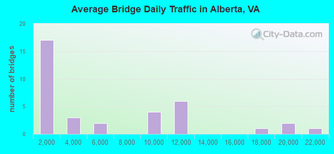
- 203,947Total average daily traffic
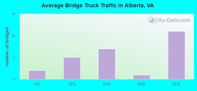
- 28,730Total average daily truck traffic
- National Bridge Inventory (NBI) Registered Bridges for Alberta
- No street view available for this location
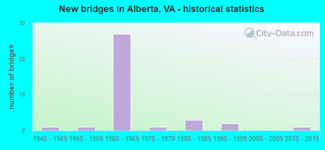
- New bridges - historical statistics
- 11940-1949
- 11950-1959
- 271960-1969
- 11970-1979
- 31980-1989
- 21990-1999
- 12010-2019
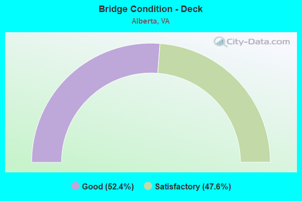
- Bridge Condition - Deck
- 52.4%Good
- 47.6%Satisfactory
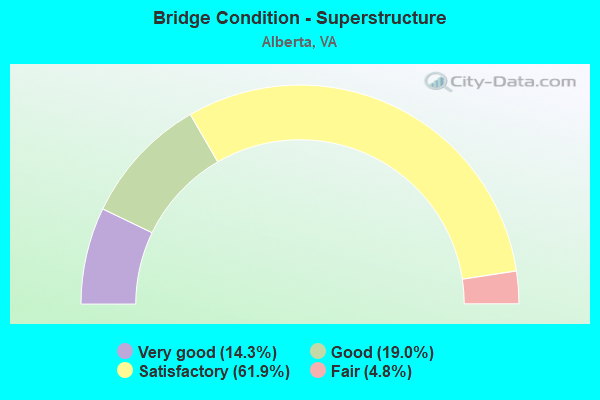
- Bridge Condition - Superstructure
- 14.3%Very good
- 19.0%Good
- 61.9%Satisfactory
- 4.8%Fair
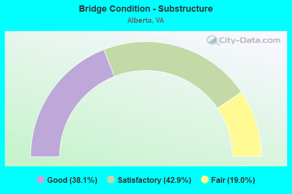
- Bridge Condition - Substructure
- 38.1%Good
- 42.9%Satisfactory
- 19.0%Fair
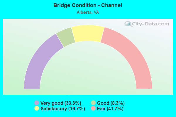
- Bridge Condition - Channel
- 33.3%Very good
- 8.3%Good
- 16.7%Satisfactory
- 41.7%Fair

- Bridge Condition - Culverts
- 60.0%Good
- 20.0%Satisfactory
- 20.0%Fair
Find on map >> Show street view
Structure Number: 903, Location: .15 TO 783 & .04 TO SCVCL (Lat: 37.751208, Lng: -79.997228), Route carried "on" structure: State highway 18, Year Built: 1941, Status: Open, Structure Length: 7.81m (25.62ft), Average Daily Traffic: 1,490 (year 2020), Truck Traffic: 1%, Average Future Daily Traffic: 1,639 (year 2040), Design Load: H 15, Features Intersected: POTTS CREEK, Facility Carried by Structure: POTTS CREEK ROAD
Minimum Vertical Clearance: 30+ m (98+ ft), Kilometerpoint: 37.783, Lanes on structure: 2, Owner: State Highway Agency, Approaching Roadway Width: 6.1m (20.0ft), Material/Design: Steel continuous, Design/Construction: Stringer/Multi-beam, Number Of Spans In Main Unit: 2, Number Of Approach Spans: 2, Length of Maximum Span: 27.6m (90.6ft), Curb or Sidewalk Widths: Left: 0.2m (0.7ft), Right: 0.2m (0.7ft), Curb-To-Curb Width: 7.3m (24.0ft), Out-to-Out Width: 8.2m (26.9ft)
Condition: Deck: Satisfactory, Superstructure: Fair, Substructure: Satisfactory, Channel: Good, Operating Rating: 33.3 metric tons, Method Used To Determine Operating Rating: Load and Resistance Factor (LRFR), Inventory Rating: 25.8 metric tons, Method Used To Determine Inventory Rating: Load and Resistance Factor (LRFR), Structural Evaluation: Somewhat better than minimum adequacy, Deck Geometry: Meets minimum limits, Waterway Adequacy: Better than present minimum criteria, Approach Roadway Alignment: Better than present minimum criteria, Length Of Structure Improvement: 7.83m (25.69ft), Designated Inspection Frequency: Every 24 months, Inspection Date: November 2020, Bridge Improvement Cost: $1,045,000, Roadway Improvement Cost: $105,000, Total Project Cost: $1,250,000 ( Estimate for 2014), Deck Structure Type: Concrete Cast-file-Place, Wearing Surface/Protective System: Wearing Surface: Latex Concrete
Find on map >> Show street view
Structure Number: 2793, Location: 1.30-RT 744;0.70-RT 746 (Lat: 37.302900, Lng: -79.593183), Route carried "on" structure: County highway 680, Year Built: 1987, Status: Open, Structure Length: 0.79m (2.59ft), Average Daily Traffic: 81 (year 2019), Average Future Daily Traffic: 115 (year 2040), Design Load: HS 20, Features Intersected: Fiddlers Creek
Minimum Vertical Clearance: 30+ m (98+ ft), Kilometerpoint: 1.191, Lanes on structure: 2, Owner: State Highway Agency, Approaching Roadway Width: 4.9m (16.1ft), Material/Design: Concrete, Design/Construction: Culvert, Number Of Spans In Main Unit: 3, Length of Maximum Span: 2.4m (7.9ft)
Condition: Channel: Satisfactory, Culverts: Good, Operating Rating: 54.4 metric tons, Method Used To Determine Operating Rating: Load Factor (LF), Inventory Rating: 32.7 metric tons, Method Used To Determine Inventory Rating: Load Factor (LF), Structural Evaluation: Better than present minimum criteria, Waterway Adequacy: Better than present minimum criteria, Approach Roadway Alignment: Meets minimum limits, Designated Inspection Frequency: Every 24 months, Inspection Date: March 2022
Find on map >> Show street view
Structure Number: 3571, Location: .64 FR 763 & .51 TO 1 (Lat: 36.831042, Lng: -77.912703), Route carried "on" structure: State highway 46, Year Built: 1957, Year Reconstructed: 2010, Status: Open, Structure Length: 4.42m (14.50ft), Average Daily Traffic: 2,506 (year 2020), Truck Traffic: 13%, Average Future Daily Traffic: 2,757 (year 2040), Design Load: HS 20+Mod, Features Intersected: CSX RAILWAY (ABANDONED), Facility Carried by Structure: CHRISTANNA HIGHWAY
Minimum Vertical Clearance: 30+ m (98+ ft), Kilometerpoint: 38.476, Lanes on structure: 2, Base Highway Network: Yes, Owner: State Highway Agency, Approaching Roadway Width: 7.9m (25.9ft), Skew: 2 degrees, Material/Design: Steel continuous, Design/Construction: Stringer/Multi-beam, Number Of Spans In Main Unit: 3, Length of Maximum Span: 14.5m (47.6ft), Curb or Sidewalk Widths: Left: 0.3m (1.0ft), Right: 0.3m (1.0ft), Curb-To-Curb Width: 9.7m (31.8ft), Out-to-Out Width: 10.1m (33.1ft)
Condition: Deck: Good, Superstructure: Very good, Substructure: Good, Operating Rating: 54.6 metric tons, Method Used To Determine Operating Rating: Load and Resistance Factor (LRFR), Inventory Rating: 42.1 metric tons, Method Used To Determine Inventory Rating: Load and Resistance Factor (LRFR), Structural Evaluation: Better than present minimum criteria, Deck Geometry: Meets minimum limits, Approach Roadway Alignment: Equal to present minimum criteria, Length Of Structure Improvement: 4.57m (14.99ft), Designated Inspection Frequency: Every 24 months, Inspection Date: September 2020, Bridge Improvement Cost: $850,000, Roadway Improvement Cost: $850,000, Total Project Cost: $1,740,000 ( Estimate for 2016), Deck Structure Type: Concrete Cast-file-Place, Wearing Surface/Protective System: Wearing Surface: Monolithic Concrete, Deck Protection: Epoxy Coated Reinforcing
Find on map >> Show street view
Structure Number: 3577, Location: .36 FR 378 & .12 TO 648 (Lat: 36.845983, Lng: -77.915600), Route carried "on" structure: State highway 46, Year Built: 1969, Status: Open, Structure Length: 5.20m (17.06ft), Average Daily Traffic: 1,842 (year 2020), Truck Traffic: 17%, Average Future Daily Traffic: 2,042 (year 2040), Design Load: HS 20+Mod, Features Intersected: ROUTE I-85 (SBL), Facility Carried by Structure: CHRISTANNA HIGWAY
Minimum Vertical Clearance: 30+ m (98+ ft), Kilometerpoint: 40.157, Lanes on structure: 2, Lanes under structure: 2, Base Highway Network: Yes, Owner: State Highway Agency, Approaching Roadway Width: 9.8m (32.2ft), Skew: 2 degrees, Material/Design: Prestressed concrete, Design/Construction: Stringer/Multi-beam, Number Of Spans In Main Unit: 3, Length of Maximum Span: 20.7m (67.9ft), Curb or Sidewalk Widths: Left: 0.5m (1.6ft), Right: 0.5m (1.6ft), Curb-To-Curb Width: 10.0m (32.8ft), Out-to-Out Width: 11.0m (36.1ft)
Condition: Deck: Satisfactory, Superstructure: Satisfactory, Substructure: Fair, Operating Rating: 55.3 metric tons, Method Used To Determine Operating Rating: Load and Resistance Factor (LRFR), Inventory Rating: 39.0 metric tons, Method Used To Determine Inventory Rating: Load and Resistance Factor (LRFR), Structural Evaluation: Somewhat better than minimum adequacy, Deck Geometry: Somewhat better than minimum adequacy, Underclear: Meets minimum limits, Approach Roadway Alignment: Equal to present desirable criteria, Length Of Structure Improvement: 5.21m (17.09ft), Designated Inspection Frequency: Every 24 months, Inspection Date: Febuary 2022, Bridge Improvement Cost: $345,000, Roadway Improvement Cost: $100,000, Total Project Cost: $548,000 ( Estimate for 2014), Deck Structure Type: Concrete Cast-file-Place
Find on map >> Show street view
Structure Number: 3579, Location: .30 FR 378 & .18 TO 648 (Lat: 36.845181, Lng: -77.915436), Route carried "on" structure: State highway 46, Year Built: 1969, Status: Open, Structure Length: 5.14m (16.86ft), Average Daily Traffic: 1,842 (year 2020), Truck Traffic: 12%, Average Future Daily Traffic: 2,042 (year 2040), Design Load: HS 20+Mod, Features Intersected: ROUTE I-85 (NBL), Facility Carried by Structure: CHRISTANNA HIGWAY
Minimum Vertical Clearance: 30+ m (98+ ft), Kilometerpoint: 40.061, Lanes on structure: 2, Lanes under structure: 2, Base Highway Network: Yes, Owner: State Highway Agency, Approaching Roadway Width: 9.8m (32.2ft), Skew: 2 degrees, Material/Design: Prestressed concrete, Design/Construction: Stringer/Multi-beam, Number Of Spans In Main Unit: 3, Length of Maximum Span: 20.7m (67.9ft), Curb or Sidewalk Widths: Left: 0.5m (1.6ft), Right: 0.5m (1.6ft), Curb-To-Curb Width: 10.0m (32.8ft), Out-to-Out Width: 11.0m (36.1ft)
Condition: Deck: Satisfactory, Superstructure: Satisfactory, Substructure: Fair, Operating Rating: 56.2 metric tons, Method Used To Determine Operating Rating: Load and Resistance Factor (LRFR), Inventory Rating: 39.9 metric tons, Method Used To Determine Inventory Rating: Load and Resistance Factor (LRFR), Structural Evaluation: Somewhat better than minimum adequacy, Deck Geometry: Somewhat better than minimum adequacy, Underclear: Somewhat better than minimum adequacy, Approach Roadway Alignment: Equal to present desirable criteria, Length Of Structure Improvement: 5.43m (17.81ft), Designated Inspection Frequency: Every 24 months, Inspection Date: Febuary 2022, Bridge Improvement Cost: $2,136,000, Roadway Improvement Cost: $1,068,000, Total Project Cost: $3,244,000 ( Estimate for 2016), Deck Structure Type: Concrete Cast-file-Place
Find on map >> Show street view
Structure Number: 3613, Location: 1.93 FR 644R &.8 TO 46 (Lat: 36.837897, Lng: -77.926594), Route carried "on" structure: Interstate 85, Year Built: 1968, Status: Open, Structure Length: 0.72m (2.36ft), Average Daily Traffic: 9,881 (year 2020), Truck Traffic: 20%, Average Future Daily Traffic: 13,833 (year 2040), Design Load: HS 20, Features Intersected: BRANCH of GREAT CREEK
Minimum Vertical Clearance: 30+ m (98+ ft), Kilometerpoint: 42.864, Lanes on structure: 2, Base Highway Network: Yes, Owner: State Highway Agency, Approaching Roadway Width: 13.4m (44.0ft), Skew: 4 degrees, Material/Design: Concrete, Design/Construction: Culvert, Number Of Spans In Main Unit: 2, Length of Maximum Span: 2.4m (7.9ft)
Condition: Channel: Fair, Culverts: Fair, Operating Rating: 58.2 metric tons, Method Used To Determine Operating Rating: Load and Resistance Factor (LRFR), Inventory Rating: 44.8 metric tons, Method Used To Determine Inventory Rating: Load and Resistance Factor (LRFR), Structural Evaluation: Somewhat better than minimum adequacy, Waterway Adequacy: Somewhat better than minimum adequacy, Approach Roadway Alignment: Equal to present desirable criteria, Length Of Structure Improvement: 0.61m (2.00ft), Designated Inspection Frequency: Every 24 months, Inspection Date: August 2020, Bridge Improvement Cost: $82,000, Roadway Improvement Cost: $41,000, Total Project Cost: $132,000 ( Estimate for 2016)
Find on map >> Show street view
Structure Number: 3614, Location: 1.95 FR 644R &.76 TO 46 (Lat: 36.838686, Lng: -77.926514), Route carried "on" structure: Interstate 85, Year Built: 1968, Status: Open, Structure Length: 0.67m (2.20ft), Average Daily Traffic: 10,182 (year 2020), Truck Traffic: 20%, Average Future Daily Traffic: 14,255 (year 2040), Design Load: HS 20, Features Intersected: BRANCH of GREAT CREEK
Minimum Vertical Clearance: 30+ m (98+ ft), Kilometerpoint: 42.928, Lanes on structure: 2, Base Highway Network: Yes, Owner: State Highway Agency, Approaching Roadway Width: 13.4m (44.0ft), Skew: 4 degrees, Material/Design: Concrete, Design/Construction: Culvert, Number Of Spans In Main Unit: 2, Length of Maximum Span: 3.0m (9.8ft)
Condition: Channel: Fair, Culverts: Satisfactory, Operating Rating: 54.4 metric tons, Method Used To Determine Operating Rating: Field evaluation and documented engineering judgment, Inventory Rating: 32.7 metric tons, Method Used To Determine Inventory Rating: Field evaluation and documented engineering judgment, Structural Evaluation: Equal to present minimum criteria, Waterway Adequacy: Equal to present minimum criteria, Approach Roadway Alignment: Equal to present desirable criteria, Length Of Structure Improvement: 5.36m (17.59ft), Designated Inspection Frequency: Every 24 months, Inspection Date: August 2020, Bridge Improvement Cost: $141,000, Roadway Improvement Cost: $70,000, Total Project Cost: $221,000 ( Estimate for 2016)
Find on map >> Show street view
Structure Number: 3624, Location: 1.88 FR RT 1 4.27 TO 630 (Lat: 36.853211, Lng: -77.858478), Route carried "on" structure: Interstate 85, Year Built: 1969, Status: Open, Structure Length: 3.66m (12.01ft), Average Daily Traffic: 10,048 (year 2020), Truck Traffic: 20%, Average Future Daily Traffic: 14,067 (year 2040), Design Load: HS 20+Mod, Features Intersected: PITCHKETTLE ROAD RTE 614
Minimum Vertical Clearance: 30+ m (98+ ft), Kilometerpoint: 49.461, Lanes on structure: 2, Lanes under structure: 2, Base Highway Network: Yes, Owner: State Highway Agency, Approaching Roadway Width: 13.4m (44.0ft), Skew: 2 degrees, Material/Design: Concrete, Design/Construction: Tee Beam, Number Of Spans In Main Unit: 3, Length of Maximum Span: 14.2m (46.6ft), Curb or Sidewalk Widths: Left: 0.6m (2.0ft), Right: 0.6m (2.0ft), Curb-To-Curb Width: 11.6m (38.1ft), Out-to-Out Width: 12.2m (40.0ft)
Condition: Deck: Good, Superstructure: Satisfactory, Substructure: Good, Operating Rating: 55.3 metric tons, Method Used To Determine Operating Rating: Load and Resistance Factor (LRFR), Inventory Rating: 42.6 metric tons, Method Used To Determine Inventory Rating: Load and Resistance Factor (LRFR), Structural Evaluation: Equal to present minimum criteria, Deck Geometry: Equal to present minimum criteria, Underclear: Somewhat better than minimum adequacy, Approach Roadway Alignment: Equal to present desirable criteria, Length Of Structure Improvement: 3.66m (12.01ft), Designated Inspection Frequency: Every 24 months, Inspection Date: Febuary 2022, Bridge Improvement Cost: $960,000, Roadway Improvement Cost: $480,000, Total Project Cost: $1,450,000 ( Estimate for 2015), Deck Structure Type: Concrete Cast-file-Place, Wearing Surface/Protective System: Wearing Surface: Epoxy Overlay
Find on map >> Show street view
Structure Number: 3626, Location: 2.17 FR RT 1 4.26 TO R630 (Lat: 36.853911, Lng: -77.858614), Route carried "on" structure: Interstate 85, Year Built: 1969, Status: Open, Structure Length: 3.66m (12.01ft), Average Daily Traffic: 10,223 (year 2020), Truck Traffic: 20%, Average Future Daily Traffic: 14,312 (year 2040), Design Load: HS 20+Mod, Features Intersected: PITCHKETTLE ROAD RTE 614
Minimum Vertical Clearance: 30+ m (98+ ft), Kilometerpoint: 49.512, Lanes on structure: 2, Lanes under structure: 2, Base Highway Network: Yes, Owner: State Highway Agency, Approaching Roadway Width: 13.4m (44.0ft), Skew: 1 degrees, Material/Design: Concrete, Design/Construction: Tee Beam, Number Of Spans In Main Unit: 3, Length of Maximum Span: 14.3m (46.9ft), Curb or Sidewalk Widths: Left: 0.6m (2.0ft), Right: 0.6m (2.0ft), Curb-To-Curb Width: 11.6m (38.1ft), Out-to-Out Width: 13.4m (44.0ft)
Condition: Deck: Good, Superstructure: Satisfactory, Substructure: Good, Operating Rating: 59.9 metric tons, Method Used To Determine Operating Rating: Load and Resistance Factor (LRFR), Inventory Rating: 46.3 metric tons, Method Used To Determine Inventory Rating: Load and Resistance Factor (LRFR), Structural Evaluation: Equal to present minimum criteria, Deck Geometry: Equal to present minimum criteria, Underclear: Somewhat better than minimum adequacy, Approach Roadway Alignment: Equal to present desirable criteria, Designated Inspection Frequency: Every 24 months, Inspection Date: Febuary 2022, Deck Structure Type: Concrete Cast-file-Place, Wearing Surface/Protective System: Wearing Surface: Epoxy Overlay
Find on map >> Show street view
Structure Number: 3628, Location: 2.05 RTE.1 4.08 RTE.630 (Lat: 36.854600, Lng: -77.855622), Route carried "on" structure: Interstate 85, Year Built: 1969, Status: Open, Structure Length: 4.91m (16.11ft), Average Daily Traffic: 10,048 (year 2020), Truck Traffic: 20%, Average Future Daily Traffic: 14,067 (year 2040), Design Load: HS 20+Mod, Features Intersected: N&S RAILWAY (ABANDONED)
Minimum Vertical Clearance: 30+ m (98+ ft), Kilometerpoint: 49.734, Lanes on structure: 2, Base Highway Network: Yes, Owner: State Highway Agency, Approaching Roadway Width: 13.4m (44.0ft), Skew: 2 degrees, Material/Design: Prestressed concrete, Design/Construction: Stringer/Multi-beam, Number Of Spans In Main Unit: 3, Length of Maximum Span: 15.5m (50.9ft), Curb-To-Curb Width: 11.6m (38.1ft), Out-to-Out Width: 12.8m (42.0ft)
Condition: Deck: Satisfactory, Superstructure: Satisfactory, Substructure: Fair, Operating Rating: 80.7 metric tons, Method Used To Determine Operating Rating: Load and Resistance Factor (LRFR), Inventory Rating: 47.2 metric tons, Method Used To Determine Inventory Rating: Load and Resistance Factor (LRFR), Structural Evaluation: Somewhat better than minimum adequacy, Deck Geometry: Equal to present minimum criteria, Approach Roadway Alignment: Equal to present desirable criteria, Length Of Structure Improvement: 4.82m (15.81ft), Designated Inspection Frequency: Every 24 months, Inspection Date: April 2020, Bridge Improvement Cost: $1,896,000, Roadway Improvement Cost: $948,000, Total Project Cost: $2,850,000, Deck Structure Type: Concrete Cast-file-Place, Wearing Surface/Protective System: Wearing Surface: Epoxy Overlay
Find on map >> Show street view
Structure Number: 3629, Location: 2.4 RTE.1 & 1.13 TO R.A. (Lat: 36.855022, Lng: -77.856339), Route carried "on" structure: Interstate 85, Year Built: 1969, Status: Open, Structure Length: 4.91m (16.11ft), Average Daily Traffic: 10,223 (year 2020), Truck Traffic: 20%, Average Future Daily Traffic: 14,312 (year 2040), Design Load: HS 20+Mod, Features Intersected: N&S RAILWAY (ABANDONED)
Minimum Vertical Clearance: 30+ m (98+ ft), Kilometerpoint: 49.766, Lanes on structure: 2, Base Highway Network: Yes, Owner: State Highway Agency, Approaching Roadway Width: 13.4m (44.0ft), Skew: 2 degrees, Material/Design: Prestressed concrete, Design/Construction: Stringer/Multi-beam, Number Of Spans In Main Unit: 3, Length of Maximum Span: 15.5m (50.9ft), Curb-To-Curb Width: 11.6m (38.1ft), Out-to-Out Width: 12.8m (42.0ft)
Condition: Deck: Satisfactory, Superstructure: Satisfactory, Substructure: Satisfactory, Operating Rating: 80.7 metric tons, Method Used To Determine Operating Rating: Load and Resistance Factor (LRFR), Inventory Rating: 47.2 metric tons, Method Used To Determine Inventory Rating: Load and Resistance Factor (LRFR), Structural Evaluation: Equal to present minimum criteria, Deck Geometry: Equal to present minimum criteria, Approach Roadway Alignment: Equal to present desirable criteria, Designated Inspection Frequency: Every 24 months, Inspection Date: April 2020, Deck Structure Type: Concrete Cast-file-Place, Wearing Surface/Protective System: Wearing Surface: Epoxy Overlay
Find on map >> Show street view
Structure Number: 3638, Location: 1.48 TO 644 1.05 TO 46 (Lat: 36.835744, Lng: -77.930486), Route carried "on" structure: Interstate 85, Year Built: 1969, Status: Open, Structure Length: 4.51m (14.80ft), Average Daily Traffic: 9,881 (year 2020), Truck Traffic: 20%, Average Future Daily Traffic: 13,833 (year 2040), Design Load: HS 20+Mod, Features Intersected: GREAT CREEK
Minimum Vertical Clearance: 30+ m (98+ ft), Kilometerpoint: 42.445, Lanes on structure: 2, Base Highway Network: Yes, Owner: State Highway Agency, Approaching Roadway Width: 13.4m (44.0ft), Skew: 1 degrees, Material/Design: Prestressed concrete, Design/Construction: Stringer/Multi-beam, Number Of Spans In Main Unit: 3, Length of Maximum Span: 14.9m (48.9ft), Curb-To-Curb Width: 11.6m (38.1ft), Out-to-Out Width: 12.8m (42.0ft)
Condition: Deck: Satisfactory, Superstructure: Good, Substructure: Satisfactory, Channel: Very good, Operating Rating: 82.6 metric tons, Method Used To Determine Operating Rating: Load and Resistance Factor (LRFR), Inventory Rating: 54.4 metric tons, Method Used To Determine Inventory Rating: Load and Resistance Factor (LRFR), Structural Evaluation: Equal to present minimum criteria, Deck Geometry: Equal to present minimum criteria, Waterway Adequacy: Equal to present minimum criteria, Approach Roadway Alignment: Equal to present desirable criteria, Designated Inspection Frequency: Every 24 months, Inspection Date: April 2020, Deck Structure Type: Concrete Cast-file-Place, Wearing Surface/Protective System: Wearing Surface: Epoxy Overlay
Find on map >> Show street view
Structure Number: 3639, Location: 1.87 FR 644 & 1.06 TO 46 (Lat: 36.836150, Lng: -77.931094), Route carried "on" structure: Interstate 85, Year Built: 1969, Status: Open, Structure Length: 4.75m (15.58ft), Average Daily Traffic: 10,182 (year 2020), Truck Traffic: 20%, Average Future Daily Traffic: 14,255 (year 2040), Design Load: HS 20+Mod, Features Intersected: GREAT CREEK
Minimum Vertical Clearance: 30+ m (98+ ft), Kilometerpoint: 42.429, Lanes on structure: 2, Base Highway Network: Yes, Owner: State Highway Agency, Approaching Roadway Width: 13.4m (44.0ft), Skew: 1 degrees, Material/Design: Prestressed concrete, Design/Construction: Stringer/Multi-beam, Number Of Spans In Main Unit: 3, Length of Maximum Span: 15.8m (51.8ft), Curb-To-Curb Width: 11.6m (38.1ft), Out-to-Out Width: 12.8m (42.0ft)
Condition: Deck: Good, Superstructure: Good, Substructure: Fair, Channel: Fair, Operating Rating: 83.5 metric tons, Method Used To Determine Operating Rating: Load and Resistance Factor (LRFR), Inventory Rating: 49.9 metric tons, Method Used To Determine Inventory Rating: Load and Resistance Factor (LRFR), Structural Evaluation: Somewhat better than minimum adequacy, Deck Geometry: Equal to present minimum criteria, Waterway Adequacy: Equal to present minimum criteria, Approach Roadway Alignment: Equal to present desirable criteria, Designated Inspection Frequency: Every 24 months, Inspection Date: April 2020, Deck Structure Type: Concrete Cast-file-Place, Wearing Surface/Protective System: Wearing Surface: Epoxy Overlay
Find on map >> Show street view
Structure Number: 364, Location: .96 FR 46 & .34 TO 1 (Lat: 36.850964, Lng: -77.900031), Route carried "on" structure: Interstate 85, Year Built: 1969, Status: Open, Structure Length: 7.10m (23.29ft), Average Daily Traffic: 9,947 (year 2020), Truck Traffic: 20%, Average Future Daily Traffic: 13,926 (year 2040), Design Load: HS 20+Mod, Features Intersected: CSX RAILWAY (ABANDONED)
Minimum Vertical Clearance: 30+ m (98+ ft), Kilometerpoint: 45.663, Lanes on structure: 3, Base Highway Network: Yes, Owner: State Highway Agency, Approaching Roadway Width: 15.2m (49.9ft), Skew: 5 degrees, Material/Design: Steel, Design/Construction: Stringer/Multi-beam, Number Of Spans In Main Unit: 3, Length of Maximum Span: 23.8m (78.1ft), Curb-To-Curb Width: 15.2m (49.9ft), Out-to-Out Width: 16.5m (54.1ft)
Condition: Deck: Satisfactory, Superstructure: Satisfactory, Substructure: Satisfactory, Operating Rating: 47.8 metric tons, Method Used To Determine Operating Rating: Load and Resistance Factor (LRFR), Inventory Rating: 36.9 metric tons, Method Used To Determine Inventory Rating: Load and Resistance Factor (LRFR), Structural Evaluation: Equal to present minimum criteria, Deck Geometry: Meets minimum limits, Approach Roadway Alignment: Equal to present desirable criteria, Length Of Structure Improvement: 8.93m (29.30ft), Designated Inspection Frequency: Every 24 months, Inspection Date: April 2021, Bridge Improvement Cost: $3,516,000, Roadway Improvement Cost: $100,000, Total Project Cost: $4,526,000, Deck Structure Type: Concrete Cast-file-Place
Find on map >> Show street view
Structure Number: 3641, Location: .89 FR 46 & .33 TO 1 (Lat: 36.850025, Lng: -77.901183), Route carried "on" structure: Interstate 85, Year Built: 1969, Status: Open, Structure Length: 7.35m (24.11ft), Average Daily Traffic: 9,719 (year 2020), Truck Traffic: 20%, Average Future Daily Traffic: 13,607 (year 2040), Design Load: HS 20+Mod, Features Intersected: CSX RAILWAY (ABANDONED)
Minimum Vertical Clearance: 30+ m (98+ ft), Kilometerpoint: 45.535, Lanes on structure: 3, Base Highway Network: Yes, Owner: State Highway Agency, Approaching Roadway Width: 15.2m (49.9ft), Skew: 5 degrees, Material/Design: Steel, Design/Construction: Stringer/Multi-beam, Number Of Spans In Main Unit: 3, Length of Maximum Span: 24.7m (81.0ft), Curb-To-Curb Width: 15.2m (49.9ft), Out-to-Out Width: 16.5m (54.1ft)
Condition: Deck: Satisfactory, Superstructure: Satisfactory, Substructure: Satisfactory, Operating Rating: 73.9 metric tons, Method Used To Determine Operating Rating: Load and Resistance Factor (LRFR), Inventory Rating: 57.0 metric tons, Method Used To Determine Inventory Rating: Load and Resistance Factor (LRFR), Structural Evaluation: Equal to present minimum criteria, Deck Geometry: Meets minimum limits, Approach Roadway Alignment: Equal to present desirable criteria, Length Of Structure Improvement: 9.17m (30.09ft), Designated Inspection Frequency: Every 24 months, Inspection Date: April 2021, Bridge Improvement Cost: $3,612,000, Roadway Improvement Cost: $1,000,000, Total Project Cost: $4,622,000, Deck Structure Type: Concrete Cast-file-Place
Find on map >> Show street view
Structure Number: 3649, Location: 1.55 FR 643 & 0.2 TO 754 (Lat: 36.885872, Lng: -77.889211), Route carried "on" structure: County highway 606, Year Built: 1990, Status: Open, Structure Length: 2.51m (8.23ft), Average Daily Traffic: 183 (year 2020), Truck Traffic: 13%, Average Future Daily Traffic: 201 (year 2040), Design Load: HS 20+Mod, Features Intersected: STURGEON CREEK, Facility Carried by Structure: MASONS MILL ROAD
Minimum Vertical Clearance: 30+ m (98+ ft), Kilometerpoint: 6.870, Lanes on structure: 2, Owner: State Highway Agency, Approaching Roadway Width: 9.8m (32.2ft), Material/Design: Steel, Design/Construction: Stringer/Multi-beam, Number Of Spans In Main Unit: 1, Length of Maximum Span: 24.4m (80.1ft), Curb or Sidewalk Widths: Left: 0.5m (1.6ft), Right: 0.5m (1.6ft), Curb-To-Curb Width: 8.5m (27.9ft), Out-to-Out Width: 9.6m (31.5ft)
Condition: Deck: Good, Superstructure: Very good, Substructure: Good, Channel: Very good, Operating Rating: 61.7 metric tons, Method Used To Determine Operating Rating: Load and Resistance Factor (LRFR), Inventory Rating: 47.2 metric tons, Method Used To Determine Inventory Rating: Load and Resistance Factor (LRFR), Structural Evaluation: Better than present minimum criteria, Deck Geometry: Equal to present minimum criteria, Waterway Adequacy: Equal to present desirable criteria, Approach Roadway Alignment: Equal to present desirable criteria, Length Of Structure Improvement: 2.74m (8.99ft), Designated Inspection Frequency: Every 24 months, Inspection Date: June 2020, Bridge Improvement Cost: $984,000, Roadway Improvement Cost: $492,000, Total Project Cost: $1,480,000 ( Estimate for 2016), Deck Structure Type: Concrete Cast-file-Place, Wearing Surface/Protective System: Deck Protection: Epoxy Coated Reinforcing
Find on map >> Show street view
Structure Number: 3702, Location: 1.2 FR 618 & .5 TO 648 (Lat: 36.855022, Lng: -77.946053), Route carried "on" structure: County highway 644, Year Built: 1981, Status: Open, Structure Length: 1.39m (4.56ft), Average Daily Traffic: 233 (year 2013), Average Future Daily Traffic: 320 (year 2040), Design Load: HS 20+Mod, Features Intersected: GREAT CREEK, Facility Carried by Structure: BRUNSWICK DRIVE
Minimum Vertical Clearance: 30+ m (98+ ft), Kilometerpoint: 39.102, Lanes on structure: 2, Owner: State Highway Agency, Approaching Roadway Width: 9.8m (32.2ft), Skew: 2 degrees, Material/Design: Concrete, Design/Construction: Culvert, Number Of Spans In Main Unit: 4, Length of Maximum Span: 3.2m (10.5ft)
Condition: Channel: Satisfactory, Culverts: Good, Operating Rating: 58.8 metric tons, Method Used To Determine Operating Rating: Load Factor (LF), Inventory Rating: 35.2 metric tons, Method Used To Determine Inventory Rating: Load Factor (LF), Structural Evaluation: Better than present minimum criteria, Waterway Adequacy: Somewhat better than minimum adequacy, Approach Roadway Alignment: Equal to present desirable criteria, Length Of Structure Improvement: 1.52m (4.99ft), Designated Inspection Frequency: Every 24 months, Inspection Date: July 2021, Bridge Improvement Cost: $32,000, Roadway Improvement Cost: $16,000, Total Project Cost: $49,000 ( Estimate for 2017)
Find on map >> Show street view
Structure Number: 3703, Location: 2.12 FR 681 & 0.2 TO 710 (Lat: 36.798911, Lng: -77.953331), Route carried "on" structure: County highway 644, Year Built: 1972, Status: Open, Structure Length: 4.67m (15.32ft), Average Daily Traffic: 460 (year 2020), Truck Traffic: 12%, Average Future Daily Traffic: 644 (year 2040), Design Load: HS 20+Mod, Features Intersected: N&S Railway (Abandoned), Facility Carried by Structure: GRANDY ROAD
Minimum Vertical Clearance: 30+ m (98+ ft), Kilometerpoint: 32.006, Lanes on structure: 2, Owner: State Highway Agency, Approaching Roadway Width: 8.5m (27.9ft), Skew: 3 degrees, Material/Design: Steel, Design/Construction: Stringer/Multi-beam, Number Of Spans In Main Unit: 3, Length of Maximum Span: 21.0m (68.9ft), Curb or Sidewalk Widths: Left: 0.6m (2.0ft), Right: 0.6m (2.0ft), Curb-To-Curb Width: 8.5m (27.9ft), Out-to-Out Width: 9.8m (32.2ft)
Condition: Deck: Good, Superstructure: Satisfactory, Substructure: Satisfactory, Operating Rating: 73.8 metric tons, Method Used To Determine Operating Rating: Load and Resistance Factor (LRFR), Inventory Rating: 56.9 metric tons, Method Used To Determine Inventory Rating: Load and Resistance Factor (LRFR), Structural Evaluation: Equal to present minimum criteria, Deck Geometry: Somewhat better than minimum adequacy, Approach Roadway Alignment: Equal to present desirable criteria, Length Of Structure Improvement: 5.15m (16.90ft), Designated Inspection Frequency: Every 24 months, Inspection Date: April 2021, Bridge Improvement Cost: $1,836,000, Roadway Improvement Cost: $918,000, Total Project Cost: $2,864,000 ( Estimate for 2017), Deck Structure Type: Concrete Cast-file-Place
Find on map >> Show street view
Structure Number: 3708, Location: .1 FR 85N .17 TO 85S RMPS (Lat: 36.821106, Lng: -77.959961), Route carried "on" structure: County highway 644, Year Built: 1969, Status: Open, Structure Length: 5.90m (19.36ft), Average Daily Traffic: 400 (year 2020), Truck Traffic: 9%, Average Future Daily Traffic: 465 (year 2040), Design Load: HS 20+Mod, Features Intersected: ROUTE I-85 (NBL), Facility Carried by Structure: BRUNSWICK DRIVE
Minimum Vertical Clearance: 30+ m (98+ ft), Kilometerpoint: 34.713, Lanes on structure: 2, Lanes under structure: 2, Owner: State Highway Agency, Approaching Roadway Width: 9.8m (32.2ft), Skew: 3 degrees, Material/Design: Steel, Design/Construction: Stringer/Multi-beam, Number Of Spans In Main Unit: 3, Length of Maximum Span: 23.2m (76.1ft), Curb or Sidewalk Widths: Left: 0.2m (0.7ft), Right: 0.2m (0.7ft), Curb-To-Curb Width: 10.0m (32.8ft), Out-to-Out Width: 11.0m (36.1ft)
Condition: Deck: Satisfactory, Superstructure: Satisfactory, Substructure: Satisfactory, Operating Rating: 66.2 metric tons, Method Used To Determine Operating Rating: Load and Resistance Factor (LRFR), Inventory Rating: 50.8 metric tons, Method Used To Determine Inventory Rating: Load and Resistance Factor (LRFR), Structural Evaluation: Equal to present minimum criteria, Deck Geometry: Better than present minimum criteria, Underclear: Somewhat better than minimum adequacy, Approach Roadway Alignment: Equal to present desirable criteria, Length Of Structure Improvement: 6.52m (21.39ft), Designated Inspection Frequency: Every 24 months, Inspection Date: March 2020, Bridge Improvement Cost: $3,210,000, Roadway Improvement Cost: $1,605,000, Total Project Cost: $4,825,000, Deck Structure Type: Concrete Cast-file-Place
Find on map >> Show street view
Structure Number: 371, Location: .17 FR 85N .1 TO 85S RMPS (Lat: 36.822056, Lng: -77.959792), Route carried "on" structure: County highway 644, Year Built: 1969, Status: Open, Structure Length: 6.00m (19.69ft), Average Daily Traffic: 400 (year 2020), Truck Traffic: 9%, Average Future Daily Traffic: 465 (year 2040), Design Load: HS 20+Mod, Features Intersected: ROUTE I-85 (SBL), Facility Carried by Structure: BRUNSWICK DRIVE
Minimum Vertical Clearance: 30+ m (98+ ft), Kilometerpoint: 34.711, Lanes on structure: 2, Lanes under structure: 2, Owner: State Highway Agency, Approaching Roadway Width: 9.8m (32.2ft), Skew: 4 degrees, Material/Design: Steel, Design/Construction: Stringer/Multi-beam, Number Of Spans In Main Unit: 3, Length of Maximum Span: 23.8m (78.1ft), Curb or Sidewalk Widths: Left: 0.2m (0.7ft), Right: 0.2m (0.7ft), Curb-To-Curb Width: 10.0m (32.8ft), Out-to-Out Width: 11.0m (36.1ft)
Condition: Deck: Satisfactory, Superstructure: Satisfactory, Substructure: Satisfactory, Operating Rating: 67.3 metric tons, Method Used To Determine Operating Rating: Load and Resistance Factor (LRFR), Inventory Rating: 51.9 metric tons, Method Used To Determine Inventory Rating: Load and Resistance Factor (LRFR), Structural Evaluation: Equal to present minimum criteria, Deck Geometry: Better than present minimum criteria, Underclear: Equal to present minimum criteria, Approach Roadway Alignment: Equal to present desirable criteria, Length Of Structure Improvement: 6.61m (21.69ft), Designated Inspection Frequency: Every 24 months, Inspection Date: March 2020, Bridge Improvement Cost: $3,255,000, Roadway Improvement Cost: $1,628,000, Total Project Cost: $4,893,000, Deck Structure Type: Concrete Cast-file-Place
Find on map >> Show street view
Structure Number: 3712, Location: 1.0 FR 46 & 1.2 TO 634 (Lat: 36.812483, Lng: -77.882281), Route carried "on" structure: County highway 646, Year Built: 1984, Status: Open, Structure Length: 0.97m (3.18ft), Average Daily Traffic: 281 (year 2013), Average Future Daily Traffic: 433 (year 2040), Design Load: HS 20+Mod, Features Intersected: ROSE CREEK, Facility Carried by Structure: PRESTWOOD ROAD
Minimum Vertical Clearance: 30+ m (98+ ft), Kilometerpoint: 1.609, Lanes on structure: 2, Owner: State Highway Agency, Approaching Roadway Width: 6.1m (20.0ft), Skew: 1 degrees, Material/Design: Concrete, Design/Construction: Culvert, Number Of Spans In Main Unit: 3, Length of Maximum Span: 3.1m (10.2ft)
Condition: Channel: Fair, Culverts: Good, Operating Rating: 54.4 metric tons, Method Used To Determine Operating Rating: Field evaluation and documented engineering judgment, Inventory Rating: 32.7 metric tons, Method Used To Determine Inventory Rating: Field evaluation and documented engineering judgment, Structural Evaluation: Better than present minimum criteria, Waterway Adequacy: Meets minimum limits, Approach Roadway Alignment: Equal to present desirable criteria, Length Of Structure Improvement: 1.07m (3.51ft), Designated Inspection Frequency: Every 24 months, Inspection Date: July 2020, Bridge Improvement Cost: $39,000, Roadway Improvement Cost: $20,000, Total Project Cost: $69,000 ( Estimate for 2016)
Find on map >> Show street view
Structure Number: 3714, Location: 1.59 FR 634 & 0.98 TO 1 (Lat: 36.849264, Lng: -77.875844), Route carried "on" structure: County highway 646, Year Built: 1969, Status: Open, Structure Length: 5.09m (16.70ft), Average Daily Traffic: 307 (year 2013), Average Future Daily Traffic: 473 (year 2040), Design Load: HS 20+Mod, Features Intersected: ROUTE I-85 (NBL), Facility Carried by Structure: PRESWOOD ROAD
Minimum Vertical Clearance: 30+ m (98+ ft), Kilometerpoint: 6.162, Lanes on structure: 2, Lanes under structure: 2, Owner: State Highway Agency, Approaching Roadway Width: 7.3m (24.0ft), Skew: 2 degrees, Material/Design: Prestressed concrete, Design/Construction: Stringer/Multi-beam, Number Of Spans In Main Unit: 3, Length of Maximum Span: 20.0m (65.6ft), Curb or Sidewalk Widths: Left: 0.6m (2.0ft), Right: 0.6m (2.0ft), Curb-To-Curb Width: 8.1m (26.6ft), Out-to-Out Width: 9.1m (29.9ft)
Condition: Deck: Good, Superstructure: Satisfactory, Substructure: Good, Operating Rating: 58.1 metric tons, Method Used To Determine Operating Rating: Load and Resistance Factor (LRFR), Inventory Rating: 44.5 metric tons, Method Used To Determine Inventory Rating: Load and Resistance Factor (LRFR), Structural Evaluation: Equal to present minimum criteria, Deck Geometry: Somewhat better than minimum adequacy, Underclear: Meets minimum limits, Approach Roadway Alignment: Equal to present minimum criteria, Length Of Structure Improvement: 5.46m (17.91ft), Designated Inspection Frequency: Every 24 months, Inspection Date: Febuary 2022, Bridge Improvement Cost: $2,148,000, Roadway Improvement Cost: $1,074,000, Total Project Cost: $3,232,000, Deck Structure Type: Concrete Cast-file-Place
Find on map >> Show street view
Structure Number: 3716, Location: 1.67 FR 634 & 0.93 TO 1 (Lat: 36.849950, Lng: -77.875486), Route carried "on" structure: County highway 646, Year Built: 1969, Status: Open, Structure Length: 5.09m (16.70ft), Average Daily Traffic: 307 (year 2013), Average Future Daily Traffic: 473 (year 2040), Design Load: HS 20+Mod, Features Intersected: ROUTE I-85 (SBL), Facility Carried by Structure: PRESWOOD ROAD
Minimum Vertical Clearance: 30+ m (98+ ft), Kilometerpoint: 6.291, Lanes on structure: 2, Lanes under structure: 2, Owner: State Highway Agency, Approaching Roadway Width: 7.3m (24.0ft), Skew: 2 degrees, Material/Design: Prestressed concrete, Design/Construction: Stringer/Multi-beam, Number Of Spans In Main Unit: 3, Length of Maximum Span: 20.0m (65.6ft), Curb or Sidewalk Widths: Left: 0.5m (1.6ft), Right: 0.5m (1.6ft), Curb-To-Curb Width: 8.1m (26.6ft), Out-to-Out Width: 9.1m (29.9ft)
Condition: Deck: Good, Superstructure: Satisfactory, Substructure: Good, Operating Rating: 47.2 metric tons, Method Used To Determine Operating Rating: Load and Resistance Factor (LRFR), Inventory Rating: 36.3 metric tons, Method Used To Determine Inventory Rating: Load and Resistance Factor (LRFR), Structural Evaluation: Equal to present minimum criteria, Deck Geometry: Somewhat better than minimum adequacy, Underclear: Equal to present minimum criteria, Approach Roadway Alignment: Equal to present minimum criteria, Length Of Structure Improvement: 5.46m (17.91ft), Designated Inspection Frequency: Every 24 months, Inspection Date: Febuary 2022, Bridge Improvement Cost: $2,148,000, Roadway Improvement Cost: $1,074,000, Total Project Cost: $3,232,000, Deck Structure Type: Concrete Cast-file-Place
Find on map >> Show street view
Structure Number: 3773, Location: 1.09 FR U.S.1 & 1.0 TO 46 (Lat: 36.812914, Lng: -77.922531), Route carried "on" structure: County highway 763, Year Built: 1968, Year Reconstructed: 2016, Status: Posted for load, Structure Length: 1.41m (4.63ft), Average Daily Traffic: 29 (year 2013), Average Future Daily Traffic: 33 (year 2040), Features Intersected: GREAT CREEK, Facility Carried by Structure: MILLEVILLE ROAD
Minimum Vertical Clearance: 30+ m (98+ ft), Kilometerpoint: 1.757, Lanes on structure: 2, Owner: State Highway Agency, Approaching Roadway Width: 6.7m (22.0ft), Material/Design: Steel continuous, Design/Construction: Stringer/Multi-beam, Number Of Spans In Main Unit: 2, Length of Maximum Span: 6.7m (22.0ft), Curb or Sidewalk Widths: Left: 0.2m (0.7ft), Right: 0.2m (0.7ft), Curb-To-Curb Width: 6.4m (21.0ft), Out-to-Out Width: 6.7m (22.0ft)
Condition: Deck: Good, Superstructure: Very good, Substructure: Satisfactory, Channel: Fair, Operating Rating: 14.5 metric tons, Method Used To Determine Operating Rating: Field evaluation and documented engineering judgment, Inventory Rating: 8.2 metric tons, Method Used To Determine Inventory Rating: Field evaluation and documented engineering judgment, Structural Evaluation: High priority of corrective action, Deck Geometry: Somewhat better than minimum adequacy, Waterway Adequacy: Equal to present minimum criteria, Approach Roadway Alignment: Equal to present minimum criteria, Bridge Posting: Required (Relationship of Operating Rating to Maximum Legal Load: 0.1 - 9.9% below), Length Of Structure Improvement: 1.43m (4.69ft), Designated Inspection Frequency: Every 12 months, Inspection Date: October 2021, Bridge Improvement Cost: $50,000, Roadway Improvement Cost: $25,000, Total Project Cost: $100,000 ( Estimate for 2016), Deck Structure Type: Wood or Timber, Wearing Surface/Protective System: Wearing Surface: Bituminous
Find on map >> Show street view
Structure Number: 23111, Location: .91 FR 763 & .97 TO 46 (Lat: 36.828478, Lng: -77.926792), Route carried "on" structure: US 1, Year Built: 1991, Status: Open, Structure Length: 2.67m (8.76ft), Average Daily Traffic: 1,398 (year 2020), Truck Traffic: 21%, Average Future Daily Traffic: 1,442 (year 2040), Design Load: HS 20+Mod, Features Intersected: GREAT CREEK, Facility Carried by Structure: BOYDTON PLANK ROAD
Minimum Vertical Clearance: 30+ m (98+ ft), Kilometerpoint: 46.645, Lanes on structure: 3, Owner: State Highway Agency, Approaching Roadway Width: 11.9m (39.0ft), Material/Design: Steel, Design/Construction: Stringer/Multi-beam, Number Of Spans In Main Unit: 1, Length of Maximum Span: 26.1m (85.6ft), Curb or Sidewalk Widths: Left: 0.5m (1.6ft), Right: 0.5m (1.6ft), Curb-To-Curb Width: 11.9m (39.0ft), Out-to-Out Width: 12.9m (42.3ft)
Condition: Deck: Good, Superstructure: Good, Substructure: Good, Channel: Very good, Operating Rating: 76.1 metric tons, Method Used To Determine Operating Rating: Load and Resistance Factor (LRFR), Inventory Rating: 58.7 metric tons, Method Used To Determine Inventory Rating: Load and Resistance Factor (LRFR), Structural Evaluation: Better than present minimum criteria, Deck Geometry: High priority of corrective action, Waterway Adequacy: Equal to present minimum criteria, Approach Roadway Alignment: Equal to present desirable criteria, Length Of Structure Improvement: 2.93m (9.61ft), Designated Inspection Frequency: Every 24 months, Inspection Date: May 2021, Bridge Improvement Cost: $240,000, Roadway Improvement Cost: $60,000, Total Project Cost: $400,000 ( Estimate for 2017), Deck Structure Type: Concrete Cast-file-Place, Wearing Surface/Protective System: Deck Protection: Epoxy Coated Reinforcing
Find on map >> Show street view
Structure Number: 2792, Location: ,4 TO 609 - 1.0 FR. 746 (Lat: 37.299417, Lng: -82.282917), Route carried "on" structure: Ramp US 80, Year Built: 2015, Status: Open, Structure Length: 9.20m (30.18ft), Average Daily Traffic: 614 (year 2020), Truck Traffic: 4%, Average Future Daily Traffic: 675 (year 2040), Design Load: HS 25 or greater, Features Intersected: ROUTE 768
Minimum Vertical Clearance: 30+ m (98+ ft), Kilometerpoint: 0.000, Lanes on structure: 2, Lanes under structure: 2, Owner: State Highway Agency, Approaching Roadway Width: 11.9m (39.0ft), Material/Design: Prestressed concrete, Design/Construction: Stringer/Multi-beam, Number Of Spans In Main Unit: 3, Length of Maximum Span: 32.6m (107.0ft), Curb-To-Curb Width: 12.3m (40.4ft), Out-to-Out Width: 13.2m (43.3ft)
Condition: Deck: Good, Superstructure: Good, Substructure: Good, Channel: Very good, Operating Rating: 89.8 metric tons, Method Used To Determine Operating Rating: Load and Resistance Factor (LRFR), Inventory Rating: 78.9 metric tons, Method Used To Determine Inventory Rating: Load and Resistance Factor (LRFR), Structural Evaluation: Better than present minimum criteria, Deck Geometry: Superior to present desirable criteria, Underclear: Superior to present desirable criteria, Waterway Adequacy: Equal to present desirable criteria, Approach Roadway Alignment: Equal to present desirable criteria, Designated Inspection Frequency: Every 24 months, Inspection Date: May 2021, Deck Structure Type: Concrete Cast-file-Place, Wearing Surface/Protective System: Deck Protection: Other Coated Reinforcing
Find on map >> Show street view
Structure Number: 3577, Location: .36 FR 378 & .12 TO 648 (Lat: 36.845983, Lng: -77.915600), Route carried "under" structure: Interstate 85, Year Built: 1969, Structure Length: 0. m, Average Daily Traffic: 5,310 (year 1994), Features Intersected: ROUTE I-85 (SBL), Facility Carried by Structure: CHRISTANNA HIGWAY
Minimum Vertical Clearance: 5.31m (17.42ft), Kilometerpoint: 44.151, Lanes on structure: 2, Lanes under structure: 2, Material/Design: Prestressed concrete, Design/Construction: Stringer/Multi-beam, Length of Maximum Span: 20.7m (67.9ft)
Find on map >> Show street view
Structure Number: 3579, Location: .30 FR 378 & .18 TO 648 (Lat: 36.845181, Lng: -77.915436), Route carried "under" structure: Interstate 85, Year Built: 1969, Structure Length: 0. m, Average Daily Traffic: 20,005 (year 2008), Truck Traffic: 11%, Features Intersected: ROUTE I-85 (NBL), Facility Carried by Structure: CHRISTANNA HIGWAY
Minimum Vertical Clearance: 5.27m (17.29ft), Kilometerpoint: 44.151, Lanes on structure: 2, Lanes under structure: 2, Material/Design: Prestressed concrete, Design/Construction: Stringer/Multi-beam, Length of Maximum Span: 20.7m (67.9ft)
Find on map >> Show street view
Structure Number: 3624, Location: 1.88 FR RT 1 4.27 TO 630 (Lat: 36.853211, Lng: -77.858478), Route carried "under" structure: County highway 614, Year Built: 1969, Structure Length: 0. m, Average Daily Traffic: 137 (year 2004), Features Intersected: PITCHKETTLE ROAD RTE 614, Facility Carried by Structure: NBL ROUTE 0085
Minimum Vertical Clearance: 5.03m (16.50ft), Kilometerpoint: 3.588, Lanes on structure: 2, Lanes under structure: 2, Material/Design: Concrete, Design/Construction: Tee Beam, Length of Maximum Span: 14.2m (46.6ft)
Find on map >> Show street view
Structure Number: 3626, Location: 2.17 FR RT 1 4.26 TO R630 (Lat: 36.853911, Lng: -77.858614), Route carried "under" structure: County highway 614, Year Built: 1969, Structure Length: 0. m, Average Daily Traffic: 137 (year 2004), Features Intersected: PITCHKETTLE ROAD RTE 614, Facility Carried by Structure: SBL I-85
Minimum Vertical Clearance: 5.43m (17.81ft), Kilometerpoint: 3.652, Lanes on structure: 2, Lanes under structure: 2, Material/Design: Concrete, Design/Construction: Tee Beam, Length of Maximum Span: 14.3m (46.9ft)
Find on map >> Show street view
Structure Number: 3634, Location: 1.22 FR 46 & 6.35 TO 630 (Lat: 36.850700, Lng: -77.895600), Route carried "under" structure: US 1, Year Built: 1969, Structure Length: 0. m, Average Daily Traffic: 2,173 (year 2008), Truck Traffic: 6%, Features Intersected: ROUTE 1, Facility Carried by Structure: NBL ROUTE 0085
Minimum Vertical Clearance: 6.55m (21.49ft), Kilometerpoint: 50.394, Lanes on structure: 2, Lanes under structure: 4, Material/Design: Steel, Design/Construction: Stringer/Multi-beam, Length of Maximum Span: 32.3m (106.0ft)
Find on map >> Show street view
Structure Number: 3636, Location: 0.12 FR.RAMP1; 3.3 R.AREA (Lat: 36.851456, Lng: -77.894300), Route carried "under" structure: US 1, Year Built: 1969, Structure Length: 0. m, Average Daily Traffic: 2,173 (year 2008), Truck Traffic: 6%, Features Intersected: ROUTE 1, Facility Carried by Structure: SBL ROUTE 0085
Minimum Vertical Clearance: 5.79m (19.00ft), Kilometerpoint: 50.523, Lanes on structure: 2, Lanes under structure: 4, Material/Design: Steel, Design/Construction: Stringer/Multi-beam, Length of Maximum Span: 30.9m (101.4ft)
Find on map >> Show street view
Structure Number: 3708, Location: .1 FR 85N .17 TO 85S RMPS (Lat: 36.821106, Lng: -77.959961), Route carried "under" structure: Interstate 85, Year Built: 1969, Structure Length: 0. m, Average Daily Traffic: 17,000 (year 1994), Truck Traffic: 6%, Features Intersected: ROUTE I-85 (NBL), Facility Carried by Structure: BRUNSWICK DRIVE
Minimum Vertical Clearance: 5.26m (17.26ft), Kilometerpoint: 39.437, Lanes on structure: 2, Lanes under structure: 2, Material/Design: Steel, Design/Construction: Stringer/Multi-beam, Length of Maximum Span: 23.2m (76.1ft)
Find on map >> Show street view
Structure Number: 371, Location: .17 FR 85N .1 TO 85S RMPS (Lat: 36.822056, Lng: -77.959792), Route carried "under" structure: Interstate 85, Year Built: 1969, Structure Length: 0. m, Average Daily Traffic: 18,971 (year 2008), Truck Traffic: 10%, Features Intersected: ROUTE I-85 (SBL), Facility Carried by Structure: BRUNSWICK DRIVE
Minimum Vertical Clearance: 5.21m (17.09ft), Kilometerpoint: 39.437, Lanes on structure: 2, Lanes under structure: 2, Material/Design: Steel, Design/Construction: Stringer/Multi-beam, Length of Maximum Span: 23.8m (78.1ft)
Find on map >> Show street view
Structure Number: 3714, Location: 1.59 FR 634 & 0.98 TO 1 (Lat: 36.849264, Lng: -77.875844), Route carried "under" structure: Interstate 85, Year Built: 1969, Structure Length: 0. m, Average Daily Traffic: 19,514 (year 2008), Truck Traffic: 10%, Features Intersected: ROUTE I-85 (NBL), Facility Carried by Structure: PRESWOOD ROAD
Minimum Vertical Clearance: 5.13m (16.83ft), Kilometerpoint: 47.836, Lanes on structure: 2, Lanes under structure: 2, Material/Design: Prestressed concrete, Design/Construction: Stringer/Multi-beam, Length of Maximum Span: 20.0m (65.6ft)
Find on map >> Show street view
Structure Number: 3716, Location: 1.67 FR 634 & 0.93 TO 1 (Lat: 36.849950, Lng: -77.875486), Route carried "under" structure: Interstate 85, Year Built: 1969, Structure Length: 0. m, Average Daily Traffic: 5,820 (year 1980), Features Intersected: ROUTE I-85 (SBL), Facility Carried by Structure: PRESWOOD ROAD
Minimum Vertical Clearance: 5.13m (16.83ft), Kilometerpoint: 47.868, Lanes on structure: 2, Lanes under structure: 2, Material/Design: Prestressed concrete, Design/Construction: Stringer/Multi-beam, Length of Maximum Span: 20.0m (65.6ft)