Bridge Statistics for Aroma Park, Illinois (IL)
Condition, Traffic, Stress, Structural Evaluation, Project Costs
- National Bridge Inventory (NBI) Statistics
- 10Number of bridges
- 102ft / 31.2mTotal length
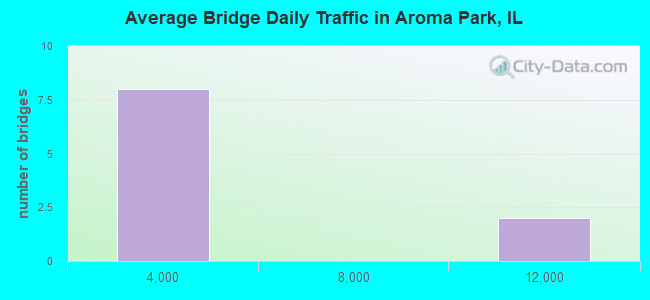
- 31,550Total average daily traffic
- 3,880Total average daily truck traffic
- National Bridge Inventory (NBI) Registered Bridges for Aroma Park
- No street view available for this location
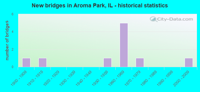
- New bridges - historical statistics
- 11900-1909
- 11910-1919
- 11950-1959
- 51960-1969
- 11970-1979
- 12000-2009

- Reconstructed bridges - Historical Statistics
- 21990-1999
- 02000-2009
- 02010-2019
- 22020-2022
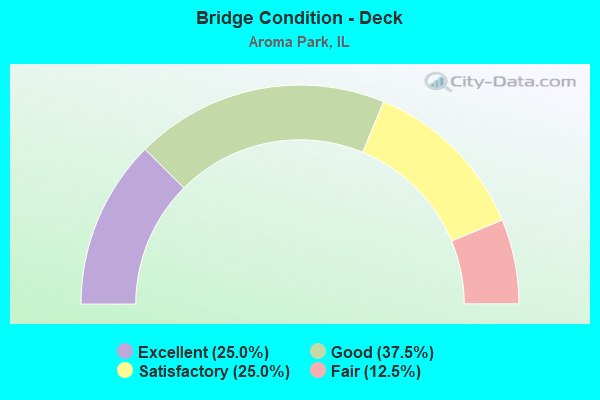
- Bridge Condition - Deck
- 25.0%Excellent
- 37.5%Good
- 25.0%Satisfactory
- 12.5%Fair
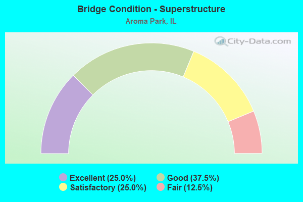
- Bridge Condition - Superstructure
- 25.0%Excellent
- 37.5%Good
- 25.0%Satisfactory
- 12.5%Fair
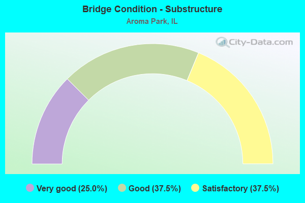
- Bridge Condition - Substructure
- 25.0%Very good
- 37.5%Good
- 37.5%Satisfactory
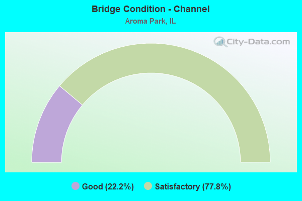
- Bridge Condition - Channel
- 22.2%Good
- 77.8%Satisfactory
Find on map >> Show street view
Structure Number: 460035, Location: 2.27 M E of I-57 (Lat: 41.119058, Lng: -87.792183), Route carried "on" structure: State highway 17, Year Built: 1964, Year Reconstructed: 2020, Status: Open, Structure Length: 3.57m (11.71ft), Average Daily Traffic: 11,500 (year 2021), Truck Traffic: 15%, Average Future Daily Traffic: 6,756 (year 2032), Design Load: HS 25 or greater, Features Intersected: Baker Creek/Exline Sloug
Minimum Vertical Clearance: 30+ m (98+ ft), Kilometerpoint: 300.987, Lanes on structure: 2, Base Highway Network: Yes, Owner: State Highway Agency, Approaching Roadway Width: 11.6m (38.1ft), Skew: 4 degrees, Material/Design: Steel continuous, Design/Construction: Stringer/Multi-beam, Number Of Spans In Main Unit: 2, Length of Maximum Span: 16.9m (55.4ft), Curb-To-Curb Width: 12.2m (40.0ft), Out-to-Out Width: 13.2m (43.3ft)
Condition: Deck: Excellent, Superstructure: Excellent, Substructure: Very good, Channel: Good, Operating Rating: 74.5 metric tons, Method Used To Determine Operating Rating: Load and Resistance Factor Rating (LRFR) rating reported by rating factor(RF) method using HL-93 loadings, Inventory Rating: 57.3 metric tons, Method Used To Determine Inventory Rating: Load and Resistance Factor Rating (LRFR) rating reported by rating factor(RF) method using HL-93 loadings, Structural Evaluation: Equal to present desirable criteria, Deck Geometry: Better than present minimum criteria, Waterway Adequacy: Equal to present desirable criteria, Approach Roadway Alignment: Equal to present desirable criteria, Designated Inspection Frequency: Every 24 months, Inspection Date: June 2020, Deck Structure Type: Concrete Cast-file-Place, Wearing Surface/Protective System: Deck Protection: Epoxy Coated Reinforcing
Find on map >> Show street view
Structure Number: 460036, Location: 2.27 M E of I-57 (Lat: 41.119061, Lng: -87.791992), Route carried "on" structure: State highway 17, Year Built: 1964, Year Reconstructed: 2020, Status: Open, Structure Length: 3.57m (11.71ft), Average Daily Traffic: 11,500 (year 2021), Truck Traffic: 15%, Average Future Daily Traffic: 6,756 (year 2032), Design Load: HS 25 or greater, Features Intersected: Baker Creek/Exline Sloug
Minimum Vertical Clearance: 30+ m (98+ ft), Kilometerpoint: 301.003, Lanes on structure: 2, Base Highway Network: Yes, Owner: State Highway Agency, Approaching Roadway Width: 11.6m (38.1ft), Skew: 4 degrees, Material/Design: Steel continuous, Design/Construction: Stringer/Multi-beam, Number Of Spans In Main Unit: 2, Length of Maximum Span: 16.8m (55.1ft), Curb-To-Curb Width: 12.2m (40.0ft), Out-to-Out Width: 13.2m (43.3ft)
Condition: Deck: Excellent, Superstructure: Excellent, Substructure: Very good, Channel: Good, Operating Rating: 75.2 metric tons, Method Used To Determine Operating Rating: Load and Resistance Factor Rating (LRFR) rating reported by rating factor(RF) method using HL-93 loadings, Inventory Rating: 58.0 metric tons, Method Used To Determine Inventory Rating: Load and Resistance Factor Rating (LRFR) rating reported by rating factor(RF) method using HL-93 loadings, Structural Evaluation: Equal to present desirable criteria, Deck Geometry: Better than present minimum criteria, Waterway Adequacy: Equal to present desirable criteria, Approach Roadway Alignment: Equal to present desirable criteria, Designated Inspection Frequency: Every 24 months, Inspection Date: June 2020, Deck Structure Type: Concrete Cast-file-Place, Wearing Surface/Protective System: Deck Protection: Epoxy Coated Reinforcing
Find on map >> Show street view
Structure Number: 463019, Location: 3.2 MI E AROMA PARK (Lat: 41.071336, Lng: -87.738647), Route carried "on" structure: County highway , Year Built: 1960, Status: Open, Structure Length: 0.98m (3.22ft), Average Daily Traffic: 1,000 (year 2021), Truck Traffic: 7%, Average Future Daily Traffic: 1,405 (year 2032), Design Load: HS 15, Features Intersected: SPRING CR, Facility Carried by Structure: CH 22
Minimum Vertical Clearance: 30+ m (98+ ft), Kilometerpoint: 5.085, Lanes on structure: 2, Owner: County Highway Agency, Approaching Roadway Width: 7.3m (24.0ft), Skew: 1 degrees, Material/Design: Concrete, Design/Construction: Channel Beam, Number Of Spans In Main Unit: 1, Length of Maximum Span: 9.1m (29.9ft), Curb-To-Curb Width: 7.3m (24.0ft), Out-to-Out Width: 8.1m (26.6ft)
Condition: Deck: Satisfactory, Superstructure: Satisfactory, Substructure: Satisfactory, Channel: Satisfactory, Operating Rating: 51.8 metric tons, Method Used To Determine Operating Rating: Load Factor (LF) rating reported by rating factor (RF) method using MS18 loading, Inventory Rating: 31.1 metric tons, Method Used To Determine Inventory Rating: Load Factor (LF) rating reported by rating factor (RF) method using MS18 loading, Structural Evaluation: Equal to present minimum criteria, Deck Geometry: Meets minimum limits, Waterway Adequacy: Equal to present minimum criteria, Approach Roadway Alignment: Equal to present desirable criteria, Designated Inspection Frequency: Every 24 months, Inspection Date: September 2021, Deck Structure Type: Concrete Precast Panels, Wearing Surface/Protective System: Wearing Surface: Bituminous
Find on map >> Show street view
Structure Number: 463023, Location: 1 MI E AROMA PARK (Lat: 41.077011, Lng: -87.779639), Route carried "on" structure: Other road , Year Built: 1957, Year Reconstructed: 1996, Status: Open, Structure Length: 3.65m (11.98ft), Average Daily Traffic: 700 (year 2021), Truck Traffic: 5%, Average Future Daily Traffic: 1,135 (year 2032), Design Load: HS 20, Features Intersected: SPRING CR, Facility Carried by Structure: CH 21/FAU 6219
Minimum Vertical Clearance: 30+ m (98+ ft), Kilometerpoint: 1.529, Lanes on structure: 2, Owner: County Highway Agency, Approaching Roadway Width: 7.3m (24.0ft), Material/Design: Prestressed concrete, Design/Construction: Box Beam or Girders - Multiple, Number Of Spans In Main Unit: 5, Length of Maximum Span: 9.1m (29.9ft), Curb-To-Curb Width: 7.3m (24.0ft), Out-to-Out Width: 7.3m (24.0ft)
Condition: Deck: Good, Superstructure: Good, Substructure: Satisfactory, Channel: Satisfactory, Operating Rating: 38.6 metric tons, Method Used To Determine Operating Rating: Load Factor (LF) rating reported by rating factor (RF) method using MS18 loading, Inventory Rating: 23.3 metric tons, Method Used To Determine Inventory Rating: Load Factor (LF) rating reported by rating factor (RF) method using MS18 loading, Structural Evaluation: Equal to present minimum criteria, Deck Geometry: Meets minimum limits, Waterway Adequacy: Equal to present minimum criteria, Approach Roadway Alignment: Equal to present desirable criteria, Designated Inspection Frequency: Every 24 months, Inspection Date: June 2020, Deck Structure Type: Concrete Precast Panels, Wearing Surface/Protective System: Wearing Surface: Bituminous, Membrane: Built-up
Find on map >> Show street view
Structure Number: 463244, Location: 3 MI W ST ANNE (Lat: 41.015150, Lng: -87.790778), Route carried "on" structure: County highway , Year Built: 1969, Status: Open, Structure Length: 0.82m (2.69ft), Average Daily Traffic: 375 (year 2021), Truck Traffic: 5%, Average Future Daily Traffic: 649 (year 2032), Design Load: HS 20, Features Intersected: DEER CR, Facility Carried by Structure: CH 3
Minimum Vertical Clearance: 30+ m (98+ ft), Kilometerpoint: 6.357, Lanes on structure: 2, Owner: County Highway Agency, Approaching Roadway Width: 7.3m (24.0ft), Skew: 1 degrees, Material/Design: Concrete, Design/Construction: Channel Beam, Number Of Spans In Main Unit: 1, Length of Maximum Span: 7.3m (24.0ft), Curb-To-Curb Width: 7.4m (24.3ft), Out-to-Out Width: 8.1m (26.6ft)
Condition: Deck: Fair, Superstructure: Fair, Substructure: Good, Channel: Satisfactory, Operating Rating: 47.0 metric tons, Method Used To Determine Operating Rating: Load Factor (LF) rating reported by rating factor (RF) method using MS18 loading, Inventory Rating: 28.2 metric tons, Method Used To Determine Inventory Rating: Load Factor (LF) rating reported by rating factor (RF) method using MS18 loading, Structural Evaluation: Somewhat better than minimum adequacy, Deck Geometry: Somewhat better than minimum adequacy, Waterway Adequacy: Equal to present minimum criteria, Approach Roadway Alignment: Equal to present desirable criteria, Designated Inspection Frequency: Every 24 months, Inspection Date: June 2020, Deck Structure Type: Concrete Precast Panels, Wearing Surface/Protective System: Wearing Surface: Bituminous
Find on map >> Show street view
Structure Number: 463276, Location: AROMA PARK (Lat: 41.075331, Lng: -87.805781), Route carried "on" structure: Other road , Year Built: 1914, Year Reconstructed: 1997, Status: Open, Structure Length: 12.80m (41.99ft), Average Daily Traffic: 2,800 (year 2021), Truck Traffic: 4%, Average Future Daily Traffic: 4,000 (year 2032), Design Load: HS 20, Features Intersected: KANKAKEE RIVER, Facility Carried by Structure: CH-3
Minimum Vertical Clearance: 30+ m (98+ ft), Kilometerpoint: 0.370, Lanes on structure: 2, Owner: County Highway Agency, Approaching Roadway Width: 7.3m (24.0ft), Material/Design: Steel continuous, Design/Construction: Stringer/Multi-beam, Number Of Spans In Main Unit: 4, Length of Maximum Span: 35.7m (117.1ft), Curb or Sidewalk Widths: Left: 0.0m, Right: 1.5m (4.9ft), Curb-To-Curb Width: 13.6m (44.6ft), Out-to-Out Width: 13.6m (44.6ft)
Condition: Deck: Good, Superstructure: Good, Substructure: Good, Channel: Satisfactory, Operating Rating: 75.8 metric tons, Method Used To Determine Operating Rating: Load Factor (LF) rating reported by rating factor (RF) method using MS18 loading, Inventory Rating: 45.4 metric tons, Method Used To Determine Inventory Rating: Load Factor (LF) rating reported by rating factor (RF) method using MS18 loading, Structural Evaluation: Better than present minimum criteria, Deck Geometry: Superior to present desirable criteria, Waterway Adequacy: Equal to present minimum criteria, Approach Roadway Alignment: Equal to present desirable criteria, Designated Inspection Frequency: Every 24 months, Underwater Inspection Frequency: Every 60 months, Inspection Date: June 2020, Underwater Inspection Date: July 2021, Deck Structure Type: Concrete Cast-file-Place, Wearing Surface/Protective System: Wearing Surface: Latex Concrete
Find on map >> Show street view
Structure Number: 463283, Location: 2.5 MI E AROMA PK (Lat: 41.079342, Lng: -87.757397), Route carried "on" structure: County highway , Year Built: 1969, Status: Open, Structure Length: 1.31m (4.30ft), Average Daily Traffic: 275 (year 2021), Truck Traffic: 1%, Average Future Daily Traffic: 486 (year 2032), Design Load: HS 15, Features Intersected: SPRING CR, Facility Carried by Structure: TR 176
Minimum Vertical Clearance: 30+ m (98+ ft), Kilometerpoint: 1.979, Lanes on structure: 2, Owner: Town or Township Highway Agency, Approaching Roadway Width: 5.2m (17.1ft), Material/Design: Prestressed concrete, Design/Construction: Box Beam or Girders - Multiple, Number Of Spans In Main Unit: 1, Length of Maximum Span: 12.8m (42.0ft), Curb-To-Curb Width: 7.6m (24.9ft), Out-to-Out Width: 8.2m (26.9ft)
Condition: Deck: Satisfactory, Superstructure: Satisfactory, Substructure: Satisfactory, Channel: Satisfactory, Operating Rating: 58.0 metric tons, Method Used To Determine Operating Rating: Load Factor (LF) rating reported by rating factor (RF) method using MS18 loading, Inventory Rating: 34.7 metric tons, Method Used To Determine Inventory Rating: Load Factor (LF) rating reported by rating factor (RF) method using MS18 loading, Structural Evaluation: Equal to present minimum criteria, Deck Geometry: Somewhat better than minimum adequacy, Waterway Adequacy: Equal to present minimum criteria, Approach Roadway Alignment: Equal to present desirable criteria, Designated Inspection Frequency: Every 24 months, Inspection Date: June 2020, Deck Structure Type: Concrete Precast Panels
Find on map >> Show street view
Structure Number: 463319, Location: 3MI E AROMA PARK (Lat: 41.078322, Lng: -87.752611), Route carried "on" structure: County highway , Year Built: 1976, Status: Open, Structure Length: 0.71m (2.33ft), Average Daily Traffic: 100 (year 2021), Truck Traffic: 10%, Average Future Daily Traffic: 108 (year 2032), Features Intersected: SPRING CREEK, Facility Carried by Structure: TR 149
Minimum Vertical Clearance: 30+ m (98+ ft), Kilometerpoint: 0.402, Lanes on structure: 2, Owner: Town or Township Highway Agency, Approaching Roadway Width: 5.5m (18.0ft), Material/Design: Steel, Design/Construction: Culvert, Number Of Spans In Main Unit: 3, Length of Maximum Span: 2.1m (6.9ft)
Condition: Channel: Satisfactory, Culverts: Good, Operating Rating: 33.4 metric tons, Method Used To Determine Operating Rating: Load Factor (LF) rating reported by rating factor (RF) method using MS18 loading, Inventory Rating: 20.1 metric tons, Method Used To Determine Inventory Rating: Load Factor (LF) rating reported by rating factor (RF) method using MS18 loading, Structural Evaluation: Somewhat better than minimum adequacy, Waterway Adequacy: Equal to present minimum criteria, Approach Roadway Alignment: Equal to present desirable criteria, Designated Inspection Frequency: Every 24 months, Inspection Date: June 2020
Find on map >> Show street view
Structure Number: 463493, Location: 1.5 MI N AROMA PARK (Lat: 41.107289, Lng: -87.811656), Route carried "on" structure: Other road , Year Built: 2008, Status: Open, Structure Length: 3.75m (12.30ft), Average Daily Traffic: 3,000 (year 2021), Truck Traffic: 6%, Average Future Daily Traffic: 3,297 (year 2032), Design Load: HS 20, Features Intersected: BAKER CR, Facility Carried by Structure: CH 38
Minimum Vertical Clearance: 30+ m (98+ ft), Kilometerpoint: 1.352, Lanes on structure: 2, Base Highway Network: Yes, Owner: County Highway Agency, Approaching Roadway Width: 11.0m (36.1ft), Skew: 3 degrees, Material/Design: Prestressed concrete, Design/Construction: Box Beam or Girders - Multiple, Number Of Spans In Main Unit: 3, Length of Maximum Span: 18.3m (60.0ft), Curb-To-Curb Width: 12.8m (42.0ft), Out-to-Out Width: 12.8m (42.0ft)
Condition: Deck: Good, Superstructure: Good, Substructure: Good, Channel: Satisfactory, Operating Rating: 44.1 metric tons, Method Used To Determine Operating Rating: Assigned rating based on Load Factor Design (LFD) reported by rating factor (RF) using MS18 loading, Inventory Rating: 32.4 metric tons, Method Used To Determine Inventory Rating: Assigned rating based on Load Factor Design (LFD) reported by rating factor (RF) using MS18 loading, Structural Evaluation: Better than present minimum criteria, Deck Geometry: Equal to present minimum criteria, Waterway Adequacy: Equal to present minimum criteria, Approach Roadway Alignment: Equal to present desirable criteria, Designated Inspection Frequency: Every 48 months, Inspection Date: May 2018, Deck Structure Type: Concrete Precast Panels, Wearing Surface/Protective System: Wearing Surface: Bituminous, Membrane: Built-up
Find on map >> Show street view
Structure Number: 46605, Location: 0.08 MI E OF BRIDGE (Lat: 41.073717, Lng: -87.805350), Route carried "under" structure: City street , Year Built: 1900, Structure Length: 0. m, Average Daily Traffic: 300 (year 2021), Truck Traffic: 1%, Features Intersected: KKK RIV & BIRCHWOOD, Facility Carried by Structure: PCT RR
Minimum Vertical Clearance: 3.53m (11.58ft), Kilometerpoint: 0.032, Lanes under structure: 1, Material/Design: Steel, Design/Construction: Stringer/Multi-beam, Length of Maximum Span: 25.0m (82.0ft)