Bridge Statistics for Auburn, Michigan (MI)
Condition, Traffic, Stress, Structural Evaluation, Project Costs
- National Bridge Inventory (NBI) Statistics
- 17Number of bridges
- 128ft / 38.6mTotal length
- $731,000Total costs
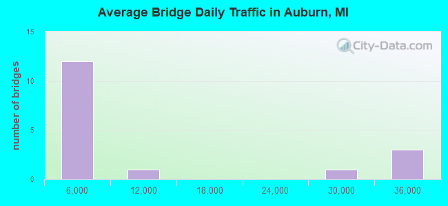
- 153,070Total average daily traffic
- 9,560Total average daily truck traffic
- National Bridge Inventory (NBI) Registered Bridges for Auburn
- No street view available for this location
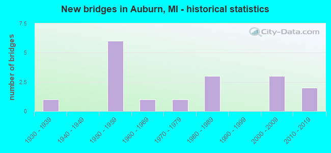
- New bridges - historical statistics
- 11930-1939
- 61950-1959
- 11960-1969
- 11970-1979
- 31980-1989
- 32000-2009
- 22010-2019
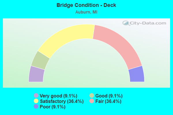
- Bridge Condition - Deck
- 9.1%Very good
- 9.1%Good
- 36.4%Satisfactory
- 36.4%Fair
- 9.1%Poor

- Bridge Condition - Superstructure
- 9.1%Very good
- 18.2%Good
- 36.4%Satisfactory
- 36.4%Fair
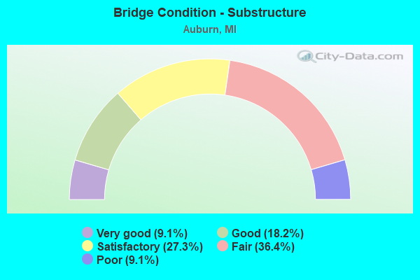
- Bridge Condition - Substructure
- 9.1%Very good
- 18.2%Good
- 27.3%Satisfactory
- 36.4%Fair
- 9.1%Poor
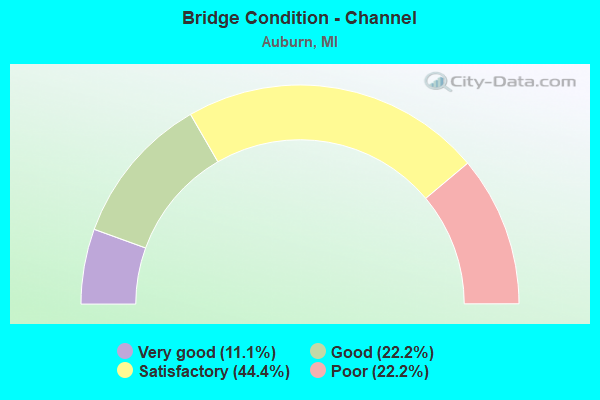
- Bridge Condition - Channel
- 11.1%Very good
- 22.2%Good
- 44.4%Satisfactory
- 22.2%Poor
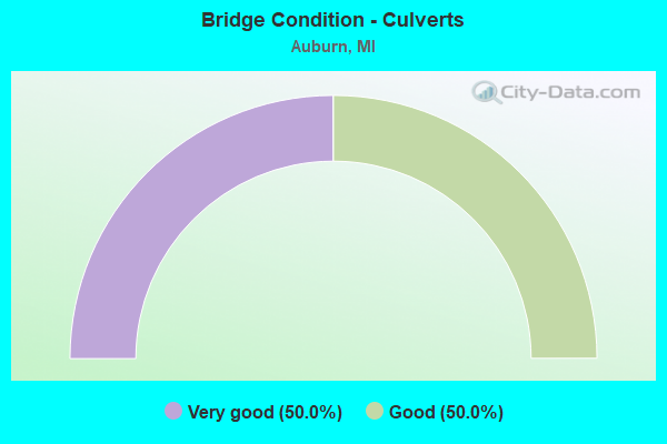
- Bridge Condition - Culverts
- 50.0%Very good
- 50.0%Good
Find on map >> Show street view
Structure Number: 664, Location: 2.0 MI W OF AUBURN (Lat: 43.597322, Lng: -84.109097), Route carried "on" structure: County highway , Year Built: 1958, Status: Open, Structure Length: 6.03m (19.78ft), Average Daily Traffic: 895 (year 1995), Truck Traffic: 3%, Average Future Daily Traffic: 430 (year 1977), Design Load: H 15, Features Intersected: US-10, Facility Carried by Structure: ELEVEN MILE RD
Minimum Vertical Clearance: 30.48m (100.00ft), Kilometerpoint: 3.232, Lanes on structure: 2, Lanes under structure: 4, Owner: State Highway Agency, Approaching Roadway Width: 11.5m (37.7ft), Material/Design: Concrete continuous, Design/Construction: Tee Beam, Number Of Spans In Main Unit: 4, Length of Maximum Span: 17.9m (58.7ft), Curb or Sidewalk Widths: Left: 0.7m (2.3ft), Right: 0.7m (2.3ft), Curb-To-Curb Width: 7.9m (25.9ft), Out-to-Out Width: 10.1m (33.1ft)
Condition: Deck: Fair, Superstructure: Fair, Substructure: Fair, Operating Rating: 51.8 metric tons, Method Used To Determine Operating Rating: Load Factor (LF) rating reported by rating factor (RF) method using MS18 loading, Inventory Rating: 31.1 metric tons, Method Used To Determine Inventory Rating: Load Factor (LF) rating reported by rating factor (RF) method using MS18 loading, Structural Evaluation: Somewhat better than minimum adequacy, Deck Geometry: Somewhat better than minimum adequacy, Underclear: Somewhat better than minimum adequacy, Approach Roadway Alignment: Better than present minimum criteria, Length Of Structure Improvement: 6.04m (19.82ft), Designated Inspection Frequency: Every 22 months, Inspection Date: June 2020, Bridge Improvement Cost: $70,000, Roadway Improvement Cost: $7,000, Total Project Cost: $82,000, Deck Structure Type: Concrete Cast-file-Place, Wearing Surface/Protective System: Wearing Surface: Monolithic Concrete
Find on map >> Show street view
Structure Number: 665, Location: 1.0 MI W OF AUBURN (Lat: 43.597067, Lng: -84.089608), Route carried "on" structure: County highway 917, Year Built: 1958, Status: Open, Structure Length: 6.03m (19.78ft), Average Daily Traffic: 2,030 (year 1983), Average Future Daily Traffic: 2,030 (year 1977), Design Load: H 15, Features Intersected: US-10, Facility Carried by Structure: GARFIELD RD
Minimum Vertical Clearance: 30.48m (100.00ft), Kilometerpoint: 3.248, Lanes on structure: 2, Lanes under structure: 4, Owner: State Highway Agency, Approaching Roadway Width: 11.8m (38.7ft), Material/Design: Concrete continuous, Design/Construction: Tee Beam, Number Of Spans In Main Unit: 4, Length of Maximum Span: 17.9m (58.7ft), Curb or Sidewalk Widths: Left: 0.7m (2.3ft), Right: 0.7m (2.3ft), Curb-To-Curb Width: 7.9m (25.9ft), Out-to-Out Width: 10.1m (33.1ft)
Condition: Deck: Poor, Superstructure: Fair, Substructure: Fair, Operating Rating: 51.2 metric tons, Method Used To Determine Operating Rating: Load Factor (LF) rating reported by rating factor (RF) method using MS18 loading, Inventory Rating: 30.5 metric tons, Method Used To Determine Inventory Rating: Load Factor (LF) rating reported by rating factor (RF) method using MS18 loading, Structural Evaluation: Somewhat better than minimum adequacy, Deck Geometry: High priority of corrective action, Underclear: Somewhat better than minimum adequacy, Approach Roadway Alignment: Somewhat better than minimum adequacy, Length Of Structure Improvement: 6.04m (19.82ft), Designated Inspection Frequency: Every 24 months, Inspection Date: August 2020, Bridge Improvement Cost: $70,000, Roadway Improvement Cost: $13,000, Total Project Cost: $151,000, Deck Structure Type: Concrete Cast-file-Place, Wearing Surface/Protective System: Wearing Surface: Latex Concrete
Find on map >> Show street view
Structure Number: 667, Location: 6.0 MI W OF BAY CITY (Lat: 43.596656, Lng: -84.031933), Route carried "on" structure: County highway 929, Year Built: 1958, Status: Open, Structure Length: 5.57m (18.27ft), Average Daily Traffic: 1,869 (year 1997), Truck Traffic: 3%, Average Future Daily Traffic: 580 (year 1977), Design Load: H 15, Features Intersected: US-10, Facility Carried by Structure: SEVEN MILE RD
Minimum Vertical Clearance: 30.48m (100.00ft), Kilometerpoint: 8.065, Lanes on structure: 2, Lanes under structure: 4, Owner: State Highway Agency, Approaching Roadway Width: 11.5m (37.7ft), Material/Design: Concrete continuous, Design/Construction: Tee Beam, Number Of Spans In Main Unit: 4, Length of Maximum Span: 16.4m (53.8ft), Curb or Sidewalk Widths: Left: 0.7m (2.3ft), Right: 0.7m (2.3ft), Curb-To-Curb Width: 7.9m (25.9ft), Out-to-Out Width: 10.1m (33.1ft)
Condition: Deck: Satisfactory, Superstructure: Fair, Substructure: Satisfactory, Operating Rating: 49.2 metric tons, Method Used To Determine Operating Rating: Load Factor (LF) rating reported by rating factor (RF) method using MS18 loading, Inventory Rating: 29.5 metric tons, Method Used To Determine Inventory Rating: Load Factor (LF) rating reported by rating factor (RF) method using MS18 loading, Structural Evaluation: Somewhat better than minimum adequacy, Deck Geometry: Meets minimum limits, Underclear: Meets minimum limits, Approach Roadway Alignment: Better than present minimum criteria, Length Of Structure Improvement: 5.58m (18.31ft), Designated Inspection Frequency: Every 24 months, Inspection Date: June 2021, Bridge Improvement Cost: $66,000, Roadway Improvement Cost: $7,000, Total Project Cost: $78,000, Deck Structure Type: Concrete Cast-file-Place, Wearing Surface/Protective System: Wearing Surface: Monolithic Concrete
Find on map >> Show street view
Structure Number: 674, Location: 600 FT W OF FRASER RD (Lat: 43.603219, Lng: -84.014522), Route carried "on" structure: County highway 926, Year Built: 2016, Status: Open, Structure Length: 1.58m (5.18ft), Average Daily Traffic: 3,957 (year 2014), Truck Traffic: 5%, Average Future Daily Traffic: 5,880 (year 2034), Design Load: Greater than HL93, Features Intersected: CULVER CREEK, Facility Carried by Structure: MIDLAND ROAD
Minimum Vertical Clearance: 30.48m (100.00ft), Kilometerpoint: 12.355, Lanes on structure: 2, Base Highway Network: Yes (Inventory Route: 76, Subroute: 2), Owner: County Highway Agency, Approaching Roadway Width: 12.2m (40.0ft), Skew: 3 degrees, Material/Design: Prestressed concrete, Design/Construction: Box Beam or Girders - Single/Spread, Number Of Spans In Main Unit: 1, Length of Maximum Span: 15.5m (50.9ft), Curb-To-Curb Width: 12.2m (40.0ft), Out-to-Out Width: 12.9m (42.3ft)
Condition: Deck: Very good, Superstructure: Very good, Substructure: Very good, Channel: Very good, Operating Rating: 69.0 metric tons, Method Used To Determine Operating Rating: Load and Resistance Factor Rating (LRFR) rating reported by rating factor(RF) method using HL-93 loadings, Inventory Rating: 53.1 metric tons, Method Used To Determine Inventory Rating: Load and Resistance Factor Rating (LRFR) rating reported by rating factor(RF) method using HL-93 loadings, Structural Evaluation: Equal to present desirable criteria, Deck Geometry: Equal to present minimum criteria, Waterway Adequacy: Equal to present desirable criteria, Approach Roadway Alignment: Equal to present desirable criteria, Designated Inspection Frequency: Every 24 months, Inspection Date: May 2020, Deck Structure Type: Concrete Cast-file-Place, Wearing Surface/Protective System: Wearing Surface: Monolithic Concrete, Deck Protection: Epoxy Coated Reinforcing
Find on map >> Show street view
Structure Number: 682, Location: 1,600 FT E OF GARFIELD RD (Lat: 43.668147, Lng: -84.081831), Route carried "on" structure: County highway 938, Year Built: 1987, Status: Posted for load, Structure Length: 1.43m (4.69ft), Average Daily Traffic: 2,870 (year 2000), Truck Traffic: 10%, Average Future Daily Traffic: 4,592 (year 2020), Design Load: HS 20+Mod, Features Intersected: KAWKAWLIN RIVER, Facility Carried by Structure: BEAVER ROAD
Minimum Vertical Clearance: 30.48m (100.00ft), Kilometerpoint: 6.875, Lanes on structure: 2, Owner: County Highway Agency, Approaching Roadway Width: 9.1m (29.9ft), Skew: 2 degrees, Material/Design: Prestressed concrete, Design/Construction: Box Beam or Girders - Multiple, Number Of Spans In Main Unit: 1, Length of Maximum Span: 13.7m (44.9ft), Curb-To-Curb Width: 12.2m (40.0ft), Out-to-Out Width: 13.4m (44.0ft)
Condition: Deck: Satisfactory, Superstructure: Satisfactory, Substructure: Fair, Channel: Good, Operating Rating: 48.6 metric tons, Method Used To Determine Operating Rating: Load Factor (LF) rating reported by rating factor (RF) method using MS18 loading, Inventory Rating: 29.5 metric tons, Method Used To Determine Inventory Rating: Load Factor (LF) rating reported by rating factor (RF) method using MS18 loading, Structural Evaluation: Somewhat better than minimum adequacy, Deck Geometry: Equal to present minimum criteria, Waterway Adequacy: Equal to present desirable criteria, Approach Roadway Alignment: Equal to present desirable criteria, Bridge Posting: Required (Relationship of Operating Rating to Maximum Legal Load: 0.1 - 9.9% below), Designated Inspection Frequency: Every 24 months, Inspection Date: May 2020, Deck Structure Type: Concrete Precast Panels, Wearing Surface/Protective System: Wearing Surface: Bituminous, Deck Protection: Epoxy Coated Reinforcing
Find on map >> Show street view
Structure Number: 712, Location: 700 FT W OF EIGHT MILE RD (Lat: 43.581678, Lng: -84.052225), Route carried "on" structure: County highway 922, Year Built: 1987, Status: Open, Structure Length: 0.70m (2.30ft), Average Daily Traffic: 2,264 (year 2000), Truck Traffic: 7%, Average Future Daily Traffic: 3,625 (year 2020), Design Load: HS 20, Features Intersected: CULVER CREEK, Facility Carried by Structure: SALZBURG ROAD
Minimum Vertical Clearance: 30.48m (100.00ft), Kilometerpoint: 9.346, Lanes on structure: 2, Owner: County Highway Agency, Approaching Roadway Width: 9.8m (32.2ft), Skew: 4 degrees, Material/Design: Concrete, Design/Construction: Culvert, Number Of Spans In Main Unit: 1, Length of Maximum Span: 6.1m (20.0ft)
Condition: Channel: Satisfactory, Culverts: Good, Operating Rating: 32.7 metric tons, Method Used To Determine Operating Rating: Field evaluation and documented engineering judgment, Inventory Rating: 19.6 metric tons, Method Used To Determine Inventory Rating: Field evaluation and documented engineering judgment, Structural Evaluation: Somewhat better than minimum adequacy, Waterway Adequacy: Equal to present desirable criteria, Approach Roadway Alignment: Equal to present desirable criteria, Designated Inspection Frequency: Every 24 months, Inspection Date: May 2020, Deck Structure Type: Concrete Precast Panels, Wearing Surface/Protective System: Wearing Surface: Bituminous, Deck Protection: Epoxy Coated Reinforcing
Find on map >> Show street view
Structure Number: 717, Location: 1000 FEET E OF 9 MI RD (Lat: 43.653564, Lng: -84.064500), Route carried "on" structure: County highway , Year Built: 1970, Status: Open, Structure Length: 1.22m (4.00ft), Average Daily Traffic: 66 (year 2000), Truck Traffic: 5%, Average Future Daily Traffic: 80 (year 2020), Design Load: HS 20+Mod, Features Intersected: KAWKAWLIN RIVER, Facility Carried by Structure: TOWNLINE 14 ROAD
Minimum Vertical Clearance: 30.48m (100.00ft), Kilometerpoint: 8.276, Lanes on structure: 2, Owner: County Highway Agency, Approaching Roadway Width: 10.4m (34.1ft), Material/Design: Wood or Timber, Design/Construction: Slab, Number Of Spans In Main Unit: 2, Length of Maximum Span: 5.7m (18.7ft), Curb-To-Curb Width: 11.6m (38.1ft), Out-to-Out Width: 12.1m (39.7ft)
Condition: Deck: Satisfactory, Superstructure: Satisfactory, Substructure: Fair, Channel: Poor, Operating Rating: 42.4 metric tons, Method Used To Determine Operating Rating: Allowable Stress (AS) rating reported by rating factor (RF) method using MS18 loading, Inventory Rating: 30.5 metric tons, Method Used To Determine Inventory Rating: Allowable Stress (AS) rating reported by rating factor (RF) method using MS18 loading, Structural Evaluation: Somewhat better than minimum adequacy, Deck Geometry: Superior to present desirable criteria, Waterway Adequacy: Better than present minimum criteria, Approach Roadway Alignment: Equal to present desirable criteria, Designated Inspection Frequency: Every 24 months, Inspection Date: May 2020, Deck Structure Type: Wood or Timber, Wearing Surface/Protective System: Wearing Surface: Bituminous
Find on map >> Show street view
Structure Number: 737, Location: 0.5 MI E OF FRASER RD (Lat: 43.610269, Lng: -84.003189), Route carried "on" structure: County highway , Year Built: 2005, Status: Open, Structure Length: 1.07m (3.51ft), Average Daily Traffic: 390 (year 2004), Truck Traffic: 2%, Average Future Daily Traffic: 630 (year 2024), Design Load: HS 20+Mod, Features Intersected: CULVER CREEK, Facility Carried by Structure: NORTH UNION ROAD
Minimum Vertical Clearance: 30.48m (100.00ft), Kilometerpoint: 2.295, Lanes on structure: 2, Owner: County Highway Agency, Approaching Roadway Width: 7.3m (24.0ft), Skew: 4 degrees, Material/Design: Concrete, Design/Construction: Culvert, Number Of Spans In Main Unit: 1, Length of Maximum Span: 9.8m (32.2ft), Curb-To-Curb Width: 9.8m (32.2ft), Out-to-Out Width: 16.4m (53.8ft)
Condition: Channel: Satisfactory, Culverts: Very good, Operating Rating: 54.5 metric tons, Method Used To Determine Operating Rating: Field evaluation and documented engineering judgment, Inventory Rating: 32.7 metric tons, Method Used To Determine Inventory Rating: Field evaluation and documented engineering judgment, Structural Evaluation: Equal to present desirable criteria, Deck Geometry: Better than present minimum criteria, Waterway Adequacy: Equal to present minimum criteria, Approach Roadway Alignment: Equal to present desirable criteria, Designated Inspection Frequency: Every 24 months, Inspection Date: May 2020, Wearing Surface/Protective System: Wearing Surface: Bituminous
Find on map >> Show street view
Structure Number: 738, Location: 0.6 MI N OF N UNION RD (Lat: 43.618414, Lng: -84.011464), Route carried "on" structure: County highway , Year Built: 1986, Status: Posted for load, Structure Length: 3.78m (12.40ft), Average Daily Traffic: 366 (year 2000), Truck Traffic: 7%, Average Future Daily Traffic: 439 (year 2020), Design Load: HS 20+Mod, Features Intersected: KAWKAWLIN RIVER, Facility Carried by Structure: FRASER ROAD
Minimum Vertical Clearance: 30.48m (100.00ft), Kilometerpoint: 2.400, Lanes on structure: 2, Owner: County Highway Agency, Approaching Roadway Width: 7.3m (24.0ft), Skew: 4 degrees, Material/Design: Prestressed concrete, Design/Construction: Tee Beam, Number Of Spans In Main Unit: 3, Length of Maximum Span: 12.5m (41.0ft), Curb-To-Curb Width: 11.3m (37.1ft), Out-to-Out Width: 11.8m (38.7ft)
Condition: Deck: Fair, Superstructure: Satisfactory, Substructure: Satisfactory, Channel: Satisfactory, Operating Rating: 40.8 metric tons, Method Used To Determine Operating Rating: Field evaluation and documented engineering judgment, Inventory Rating: 24.5 metric tons, Method Used To Determine Inventory Rating: Field evaluation and documented engineering judgment, Structural Evaluation: Equal to present minimum criteria, Deck Geometry: Superior to present desirable criteria, Waterway Adequacy: Somewhat better than minimum adequacy, Approach Roadway Alignment: Equal to present desirable criteria, Bridge Posting: Required (Relationship of Operating Rating to Maximum Legal Load: 20.0 - 29.9% below), Designated Inspection Frequency: Every 12 months, Inspection Date: May 2021, Deck Structure Type: Concrete Precast Panels, Wearing Surface/Protective System: Wearing Surface: Bituminous, Membrane: Preformed Fabric, Deck Protection: Epoxy Coated Reinforcing
Find on map >> Show street view
Structure Number: 745, Location: 200 FT E OF NINE MILE RD (Lat: 43.646783, Lng: -84.068931), Route carried "on" structure: County highway , Year Built: 2004, Status: Open, Structure Length: 1.52m (4.99ft), Average Daily Traffic: 186 (year 2004), Truck Traffic: 10%, Average Future Daily Traffic: 230 (year 2024), Design Load: HS 20+Mod, Features Intersected: KAWKAWLIN RIVER, Facility Carried by Structure: CHIP ROAD
Minimum Vertical Clearance: 30.48m (100.00ft), Kilometerpoint: 0.053, Lanes on structure: 2, Owner: County Highway Agency, Approaching Roadway Width: 7.0m (23.0ft), Material/Design: Prestressed concrete, Design/Construction: Box Beam or Girders - Multiple, Number Of Spans In Main Unit: 1, Length of Maximum Span: 14.0m (45.9ft), Curb-To-Curb Width: 9.1m (29.9ft), Out-to-Out Width: 9.5m (31.2ft)
Condition: Deck: Satisfactory, Superstructure: Good, Substructure: Good, Channel: Satisfactory, Operating Rating: 95.9 metric tons, Method Used To Determine Operating Rating: Load Factor (LF), Inventory Rating: 57.4 metric tons, Method Used To Determine Inventory Rating: Load Factor (LF), Structural Evaluation: Better than present minimum criteria, Deck Geometry: Equal to present minimum criteria, Waterway Adequacy: Equal to present minimum criteria, Approach Roadway Alignment: Better than present minimum criteria, Designated Inspection Frequency: Every 24 months, Inspection Date: May 2020, Deck Structure Type: Concrete Precast Panels, Wearing Surface/Protective System: Wearing Surface: Bituminous, Membrane: Preformed Fabric
Find on map >> Show street view
Structure Number: 746, Location: 0.5 MI S OF WHEELER RD (Lat: 43.631886, Lng: -84.049097), Route carried "on" structure: County highway , Year Built: 1934, Status: Posted for load, Structure Length: 1.22m (4.00ft), Average Daily Traffic: 380 (year 2000), Truck Traffic: 10%, Average Future Daily Traffic: 456 (year 2020), Design Load: H 20, Features Intersected: KAWKAWLIN RIVER, Facility Carried by Structure: EIGHT MILE ROAD
Minimum Vertical Clearance: 30.48m (100.00ft), Kilometerpoint: 3.742, Lanes on structure: 2, Owner: County Highway Agency, Approaching Roadway Width: 7.6m (24.9ft), Material/Design: Steel, Design/Construction: Stringer/Multi-beam, Number Of Spans In Main Unit: 1, Length of Maximum Span: 11.5m (37.7ft), Curb-To-Curb Width: 8.5m (27.9ft), Out-to-Out Width: 9.3m (30.5ft)
Condition: Deck: Fair, Superstructure: Fair, Substructure: Poor, Channel: Poor, Operating Rating: 24.9 metric tons, Method Used To Determine Operating Rating: Load Factor (LF) rating reported by rating factor (RF) method using MS18 loading, Inventory Rating: 14.9 metric tons, Method Used To Determine Inventory Rating: Load Factor (LF) rating reported by rating factor (RF) method using MS18 loading, Structural Evaluation: Meets minimum limits, Deck Geometry: Equal to present minimum criteria, Waterway Adequacy: Equal to present minimum criteria, Approach Roadway Alignment: Equal to present desirable criteria, Bridge Posting: Required (Relationship of Operating Rating to Maximum Legal Load: > 39.9% below), Length Of Structure Improvement: 1.95m (6.40ft), Designated Inspection Frequency: Every 12 months, Inspection Date: May 2021, Bridge Improvement Cost: $328,000, Roadway Improvement Cost: $70,000, Total Project Cost: $420,000, Deck Structure Type: Concrete Cast-file-Place
Find on map >> Show street view
Structure Number: 6911, Location: 1.3 MI NW OF M-30 (Lat: 43.688400, Lng: -84.393500), Route carried "on" structure: County highway 5651, Year Built: 1962, Year Reconstructed: 2013, Status: Open, Structure Length: 6.78m (22.24ft), Average Daily Traffic: 6,862 (year 1996), Truck Traffic: 5%, Average Future Daily Traffic: 5,700 (year 2015), Design Load: HS 20+Mod, Features Intersected: US-10, Facility Carried by Structure: W RIVER RD
Minimum Vertical Clearance: 30.48m (100.00ft), Kilometerpoint: 1.355, Lanes on structure: 2, Lanes under structure: 4, Owner: State Highway Agency, Approaching Roadway Width: 12.8m (42.0ft), Skew: 2 degrees, Material/Design: Steel, Design/Construction: Stringer/Multi-beam, Number Of Spans In Main Unit: 4, Length of Maximum Span: 22.9m (75.1ft), Curb-To-Curb Width: 13.4m (44.0ft), Out-to-Out Width: 14.4m (47.2ft)
Condition: Deck: Good, Superstructure: Satisfactory, Substructure: Good, Operating Rating: 61.6 metric tons, Method Used To Determine Operating Rating: Load Factor (LF) rating reported by rating factor (RF) method using MS18 loading, Inventory Rating: 36.9 metric tons, Method Used To Determine Inventory Rating: Load Factor (LF) rating reported by rating factor (RF) method using MS18 loading, Structural Evaluation: Equal to present minimum criteria, Deck Geometry: Equal to present minimum criteria, Underclear: Somewhat better than minimum adequacy, Approach Roadway Alignment: Equal to present minimum criteria, Designated Inspection Frequency: Every 24 months, Inspection Date: September 2020, Deck Structure Type: Concrete Cast-file-Place, Wearing Surface/Protective System: Wearing Surface: Monolithic Concrete, Deck Protection: Epoxy Coated Reinforcing
Find on map >> Show street view
Structure Number: 6931, Location: 0.5 MI E OF MERIDIAN RD (Lat: 43.525297, Lng: -84.360081), Route carried "on" structure: County highway , Year Built: 2003, Status: Open, Structure Length: 1.68m (5.51ft), Average Daily Traffic: 2,077 (year 2002), Truck Traffic: 3%, Average Future Daily Traffic: 3,053 (year 2022), Design Load: HS 20, Features Intersected: BULLOCK CREEK, Facility Carried by Structure: FREELAND ROAD
Minimum Vertical Clearance: 30.48m (100.00ft), Kilometerpoint: 0.785, Lanes on structure: 2, Owner: County Highway Agency, Approaching Roadway Width: 10.7m (35.1ft), Material/Design: Prestressed concrete, Design/Construction: Box Beam or Girders - Multiple, Number Of Spans In Main Unit: 1, Length of Maximum Span: 15.5m (50.9ft), Curb-To-Curb Width: 10.7m (35.1ft), Out-to-Out Width: 11.4m (37.4ft)
Condition: Deck: Fair, Superstructure: Good, Substructure: Satisfactory, Channel: Good, Operating Rating: 53.7 metric tons, Method Used To Determine Operating Rating: Load Factor (LF), Inventory Rating: 32.2 metric tons, Method Used To Determine Inventory Rating: Load Factor (LF), Structural Evaluation: Equal to present minimum criteria, Deck Geometry: Somewhat better than minimum adequacy, Waterway Adequacy: Better than present minimum criteria, Approach Roadway Alignment: Equal to present desirable criteria, Designated Inspection Frequency: Every 24 months, Inspection Date: September 2021, Deck Structure Type: Concrete Precast Panels, Wearing Surface/Protective System: Wearing Surface: Monolithic Concrete, Deck Protection: Epoxy Coated Reinforcing
Find on map >> Show street view
Structure Number: 664, Location: 2.0 MI W OF AUBURN (Lat: 43.597322, Lng: -84.109097), Route carried "under" structure: US 10, Year Built: 1958, Structure Length: 0. m, Average Daily Traffic: 29,780 (year 2007), Truck Traffic: 7%, Features Intersected: US-10, Facility Carried by Structure: ELEVEN MILE RD
Minimum Vertical Clearance: 4.80m (15.75ft), Kilometerpoint: 5.501, Lanes on structure: 2, Lanes under structure: 4, Material/Design: Concrete continuous, Design/Construction: Tee Beam, Length of Maximum Span: 17.9m (58.7ft)
Find on map >> Show street view
Structure Number: 665, Location: 1.0 MI W OF AUBURN (Lat: 43.597067, Lng: -84.089608), Route carried "under" structure: US 10, Year Built: 1958, Structure Length: 0. m, Average Daily Traffic: 31,204 (year 2007), Truck Traffic: 7%, Features Intersected: US-10, Facility Carried by Structure: GARFIELD RD
Minimum Vertical Clearance: 4.75m (15.58ft), Kilometerpoint: 7.075, Lanes on structure: 2, Lanes under structure: 4, Material/Design: Concrete continuous, Design/Construction: Tee Beam, Length of Maximum Span: 17.9m (58.7ft)
Find on map >> Show street view
Structure Number: 666, Location: S LTS OF AUBURN (Lat: 43.596772, Lng: -84.069453), Route carried "under" structure: US 10, Year Built: 2015, Structure Length: 0. m, Average Daily Traffic: 34,400 (year 2014), Truck Traffic: 6%, Features Intersected: US-10, Facility Carried by Structure: NINE MILE RD
Minimum Vertical Clearance: 4.75m (15.58ft), Kilometerpoint: 8.702, Lanes on structure: 2, Lanes under structure: 4, Material/Design: Prestressed concrete, Design/Construction: Stringer/Multi-beam, Length of Maximum Span: 25.5m (83.7ft)
Find on map >> Show street view
Structure Number: 667, Location: 6.0 MI W OF BAY CITY (Lat: 43.596656, Lng: -84.031933), Route carried "under" structure: US 10, Year Built: 1958, Structure Length: 0. m, Average Daily Traffic: 33,474 (year 2007), Truck Traffic: 6%, Features Intersected: US-10, Facility Carried by Structure: SEVEN MILE RD
Minimum Vertical Clearance: 4.82m (15.81ft), Kilometerpoint: 11.731, Lanes on structure: 2, Lanes under structure: 4, Material/Design: Concrete continuous, Design/Construction: Tee Beam, Length of Maximum Span: 16.4m (53.8ft)