Bridge Statistics for Ballantine, Montana (MT)
Condition, Traffic, Stress, Structural Evaluation, Project Costs
- National Bridge Inventory (NBI) Statistics
- 19Number of bridges
- 174ft / 53.2mTotal length
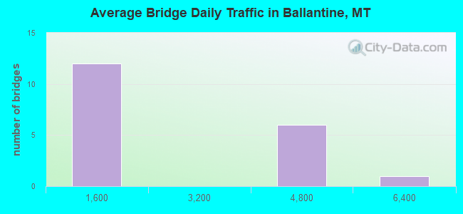
- 30,917Total average daily traffic
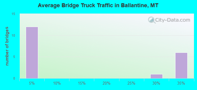
- 8,716Total average daily truck traffic
- National Bridge Inventory (NBI) Registered Bridges for Ballantine
- No street view available for this location
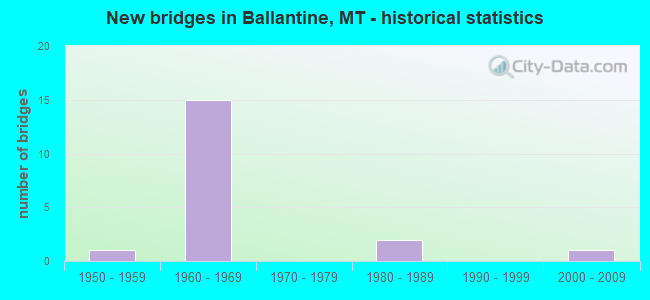
- New bridges - historical statistics
- 11950-1959
- 151960-1969
- 21980-1989
- 12000-2009
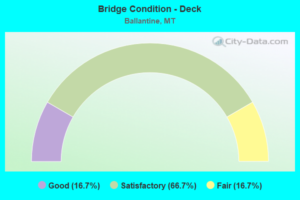
- Bridge Condition - Deck
- 16.7%Good
- 66.7%Satisfactory
- 16.7%Fair
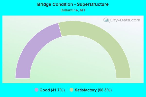
- Bridge Condition - Superstructure
- 41.7%Good
- 58.3%Satisfactory
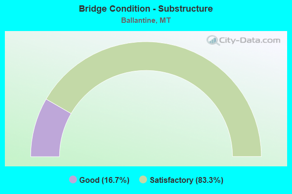
- Bridge Condition - Substructure
- 16.7%Good
- 83.3%Satisfactory
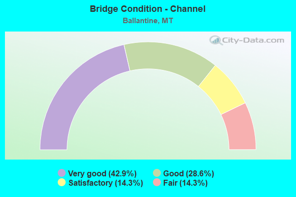
- Bridge Condition - Channel
- 42.9%Very good
- 28.6%Good
- 14.3%Satisfactory
- 14.3%Fair
Find on map >> Show street view
Structure Number: I00094014+08431, Location: BALLANTINE (Lat: 45.939406, Lng: -108.149025), Route carried "on" structure: Interstate 94, Year Built: 1968, Status: Open, Structure Length: 3.93m (12.89ft), Average Daily Traffic: 4,877 (year 2020), Truck Traffic: 25%, Average Future Daily Traffic: 5,316 (year 2040), Design Load: HS 20, Features Intersected: INT BALLANTINE
Minimum Vertical Clearance: 30+ m (98+ ft), Kilometerpoint: 23.714, Lanes on structure: 2, Lanes under structure: 2, Base Highway Network: Yes, Owner: State Highway Agency, Approaching Roadway Width: 11.6m (38.1ft), Material/Design: Prestressed concrete, Design/Construction: Stringer/Multi-beam, Number Of Spans In Main Unit: 3, Length of Maximum Span: 14.3m (46.9ft), Curb-To-Curb Width: 11.6m (38.1ft), Out-to-Out Width: 12.6m (41.3ft)
Condition: Deck: Satisfactory, Superstructure: Satisfactory, Substructure: Satisfactory, Operating Rating: 52.6 metric tons, Method Used To Determine Operating Rating: Load and Resistance Factor (LRFR), Inventory Rating: 39.0 metric tons, Method Used To Determine Inventory Rating: Load and Resistance Factor (LRFR), Structural Evaluation: Equal to present minimum criteria, Deck Geometry: Equal to present minimum criteria, Underclear: Somewhat better than minimum adequacy, Approach Roadway Alignment: Equal to present desirable criteria, Designated Inspection Frequency: Every 24 months, Inspection Date: October 2021, Deck Structure Type: Concrete Cast-file-Place, Wearing Surface/Protective System: Wearing Surface: Epoxy Overlay, Deck Protection: Other
Find on map >> Show street view
Structure Number: I00094014+08432, Location: BALLANTINE (Lat: 45.939672, Lng: -108.149222), Route carried "on" structure: Interstate 94, Year Built: 1968, Status: Open, Structure Length: 3.93m (12.89ft), Average Daily Traffic: 4,149 (year 2020), Truck Traffic: 30%, Average Future Daily Traffic: 4,522 (year 2040), Design Load: HS 20, Features Intersected: INT BALLANTINE
Minimum Vertical Clearance: 30+ m (98+ ft), Kilometerpoint: 24.446, Lanes on structure: 2, Lanes under structure: 2, Base Highway Network: Yes, Owner: State Highway Agency, Approaching Roadway Width: 11.6m (38.1ft), Material/Design: Prestressed concrete, Design/Construction: Stringer/Multi-beam, Number Of Spans In Main Unit: 3, Length of Maximum Span: 14.2m (46.6ft), Curb-To-Curb Width: 11.6m (38.1ft), Out-to-Out Width: 12.6m (41.3ft)
Condition: Deck: Satisfactory, Superstructure: Satisfactory, Substructure: Satisfactory, Operating Rating: 46.3 metric tons, Method Used To Determine Operating Rating: Load and Resistance Factor (LRFR), Inventory Rating: 32.7 metric tons, Method Used To Determine Inventory Rating: Load and Resistance Factor (LRFR), Structural Evaluation: Equal to present minimum criteria, Deck Geometry: Equal to present minimum criteria, Underclear: Meets minimum limits, Approach Roadway Alignment: Equal to present desirable criteria, Designated Inspection Frequency: Every 24 months, Inspection Date: October 2021, Deck Structure Type: Concrete Cast-file-Place, Wearing Surface/Protective System: Wearing Surface: Monolithic Concrete
Find on map >> Show street view
Structure Number: I00094015+04531, Location: 1.2M E BALLENTINE (Lat: 45.943917, Lng: -108.138386), Route carried "on" structure: Interstate 94, Year Built: 1968, Status: Open, Structure Length: 0.62m (2.03ft), Average Daily Traffic: 4,149 (year 2020), Truck Traffic: 30%, Average Future Daily Traffic: 4,522 (year 2040), Design Load: HS 20, Features Intersected: DRAINAGE
Minimum Vertical Clearance: 30+ m (98+ ft), Kilometerpoint: 24.680, Lanes on structure: 4, Base Highway Network: Yes, Owner: State Highway Agency, Approaching Roadway Width: 23.2m (76.1ft), Material/Design: Steel, Design/Construction: Culvert, Number Of Spans In Main Unit: 1, Length of Maximum Span: 6.2m (20.3ft)
Condition: Channel: Fair, Culverts: Satisfactory, Operating Rating: 44.5 metric tons, Method Used To Determine Operating Rating: Load and Resistance Factor (LRFR), Inventory Rating: 32.7 metric tons, Method Used To Determine Inventory Rating: Load and Resistance Factor (LRFR), Structural Evaluation: Equal to present minimum criteria, Waterway Adequacy: Equal to present desirable criteria, Approach Roadway Alignment: Equal to present desirable criteria, Designated Inspection Frequency: Every 24 months, Inspection Date: January 2021
Find on map >> Show street view
Structure Number: I00094016+05181, Location: 1.9M E BALLANTINE (Lat: 45.951678, Lng: -108.118808), Route carried "on" structure: Interstate 94, Year Built: 1968, Status: Open, Structure Length: 14.63m (48.00ft), Average Daily Traffic: 4,149 (year 2020), Truck Traffic: 30%, Average Future Daily Traffic: 4,522 (year 2040), Design Load: HS 20, Features Intersected: RR-HIGHLINE CANAL RD
Minimum Vertical Clearance: 30+ m (98+ ft), Kilometerpoint: 26.427, Lanes on structure: 2, Lanes under structure: 2, Base Highway Network: Yes, Owner: State Highway Agency, Approaching Roadway Width: 11.6m (38.1ft), Material/Design: Steel continuous, Design/Construction: Stringer/Multi-beam, Number Of Spans In Main Unit: 2, Number Of Approach Spans: 6, Length of Maximum Span: 23.2m (76.1ft), Curb-To-Curb Width: 11.6m (38.1ft), Out-to-Out Width: 12.5m (41.0ft)
Condition: Deck: Satisfactory, Superstructure: Satisfactory, Substructure: Satisfactory, Operating Rating: 63.5 metric tons, Method Used To Determine Operating Rating: Load Factor (LF), Inventory Rating: 31.8 metric tons, Method Used To Determine Inventory Rating: Load Factor (LF), Structural Evaluation: Equal to present minimum criteria, Deck Geometry: Equal to present minimum criteria, Underclear: Equal to present minimum criteria, Approach Roadway Alignment: Equal to present desirable criteria, Designated Inspection Frequency: Every 24 months, Critical Feature Inspection Frequency: Every 24 months, Other Special Inspection Frequency: Every 48 months, Inspection Date: June 2020, Critical Feature Inspection Date: June 2020, Other Special Inspection Date: June 2021, Deck Structure Type: Concrete Cast-file-Place, Wearing Surface/Protective System: Wearing Surface: Monolithic Concrete
Find on map >> Show street view
Structure Number: I00094016+05182, Location: 1.9M E BALLANTINE (Lat: 45.951844, Lng: -108.119267), Route carried "on" structure: Interstate 94, Year Built: 1968, Status: Open, Structure Length: 13.62m (44.69ft), Average Daily Traffic: 4,149 (year 2020), Truck Traffic: 30%, Average Future Daily Traffic: 4,522 (year 2040), Design Load: HS 20, Features Intersected: RR-HIGHLINE CANAL RD
Minimum Vertical Clearance: 30+ m (98+ ft), Kilometerpoint: 27.135, Lanes on structure: 2, Lanes under structure: 2, Base Highway Network: Yes, Owner: State Highway Agency, Approaching Roadway Width: 11.6m (38.1ft), Material/Design: Steel continuous, Design/Construction: Stringer/Multi-beam, Number Of Spans In Main Unit: 2, Number Of Approach Spans: 5, Length of Maximum Span: 23.2m (76.1ft), Curb-To-Curb Width: 11.6m (38.1ft), Out-to-Out Width: 12.5m (41.0ft)
Condition: Deck: Satisfactory, Superstructure: Satisfactory, Substructure: Satisfactory, Operating Rating: 63.5 metric tons, Method Used To Determine Operating Rating: Load Factor (LF), Inventory Rating: 31.8 metric tons, Method Used To Determine Inventory Rating: Load Factor (LF), Structural Evaluation: Equal to present minimum criteria, Deck Geometry: Equal to present minimum criteria, Underclear: Somewhat better than minimum adequacy, Approach Roadway Alignment: Equal to present desirable criteria, Designated Inspection Frequency: Every 24 months, Critical Feature Inspection Frequency: Every 24 months, Other Special Inspection Frequency: Every 48 months, Inspection Date: June 2020, Critical Feature Inspection Date: June 2020, Other Special Inspection Date: June 2021, Deck Structure Type: Concrete Cast-file-Place, Wearing Surface/Protective System: Wearing Surface: Monolithic Concrete
Find on map >> Show street view
Structure Number: I00094017+04161, Location: 2.5M E BALLANTINE (Lat: 45.958142, Lng: -108.102739), Route carried "on" structure: Interstate 94, Year Built: 1968, Status: Open, Structure Length: 4.69m (15.39ft), Average Daily Traffic: 4,149 (year 2020), Truck Traffic: 30%, Average Future Daily Traffic: 4,522 (year 2040), Design Load: HS 20, Features Intersected: EAST I RD
Minimum Vertical Clearance: 30+ m (98+ ft), Kilometerpoint: 27.866, Lanes on structure: 2, Lanes under structure: 2, Base Highway Network: Yes, Owner: State Highway Agency, Approaching Roadway Width: 11.6m (38.1ft), Skew: 3 degrees, Material/Design: Prestressed concrete, Design/Construction: Stringer/Multi-beam, Number Of Spans In Main Unit: 3, Length of Maximum Span: 18.9m (62.0ft), Curb-To-Curb Width: 11.6m (38.1ft), Out-to-Out Width: 12.5m (41.0ft)
Condition: Deck: Satisfactory, Superstructure: Satisfactory, Substructure: Satisfactory, Operating Rating: 59.0 metric tons, Method Used To Determine Operating Rating: Load and Resistance Factor (LRFR), Inventory Rating: 39.9 metric tons, Method Used To Determine Inventory Rating: Load and Resistance Factor (LRFR), Structural Evaluation: Equal to present minimum criteria, Deck Geometry: Equal to present minimum criteria, Underclear: Meets minimum limits, Approach Roadway Alignment: Equal to present desirable criteria, Designated Inspection Frequency: Every 24 months, Inspection Date: December 2020, Deck Structure Type: Concrete Cast-file-Place, Wearing Surface/Protective System: Wearing Surface: Monolithic Concrete
Find on map >> Show street view
Structure Number: I00094017+04162, Location: 2.5M E BALLANTINE (Lat: 45.958325, Lng: -108.103153), Route carried "on" structure: Interstate 94, Year Built: 1968, Status: Open, Structure Length: 4.69m (15.39ft), Average Daily Traffic: 4,149 (year 2020), Truck Traffic: 30%, Average Future Daily Traffic: 4,522 (year 2040), Design Load: HS 20, Features Intersected: EAST I RD
Minimum Vertical Clearance: 30+ m (98+ ft), Kilometerpoint: 28.579, Lanes on structure: 2, Lanes under structure: 2, Base Highway Network: Yes, Owner: State Highway Agency, Approaching Roadway Width: 11.6m (38.1ft), Skew: 3 degrees, Material/Design: Prestressed concrete, Design/Construction: Stringer/Multi-beam, Number Of Spans In Main Unit: 3, Length of Maximum Span: 18.9m (62.0ft), Curb-To-Curb Width: 11.6m (38.1ft), Out-to-Out Width: 12.5m (41.0ft)
Condition: Deck: Fair, Superstructure: Good, Substructure: Good, Operating Rating: 59.0 metric tons, Method Used To Determine Operating Rating: Load and Resistance Factor (LRFR), Inventory Rating: 39.9 metric tons, Method Used To Determine Inventory Rating: Load and Resistance Factor (LRFR), Structural Evaluation: Better than present minimum criteria, Deck Geometry: Equal to present minimum criteria, Underclear: Meets minimum limits, Approach Roadway Alignment: Equal to present desirable criteria, Designated Inspection Frequency: Every 24 months, Inspection Date: December 2020, Deck Structure Type: Concrete Cast-file-Place, Wearing Surface/Protective System: Wearing Surface: Monolithic Concrete
Find on map >> Show street view
Structure Number: L56004001+05001, Location: 1M E WORDEN (Lat: 45.958469, Lng: -108.137686), Route carried "on" structure: County highway 56004, Year Built: 1964, Status: Open, Structure Length: 0.70m (2.30ft), Average Daily Traffic: 100 (year 2022), Truck Traffic: 3%, Average Future Daily Traffic: 100 (year 2037), Design Load: HS 20, Features Intersected: ARROW CREEK 145, Facility Carried by Structure: E I RD
Minimum Vertical Clearance: 30+ m (98+ ft), Kilometerpoint: 2.022, Lanes on structure: 2, Owner: County Highway Agency, Approaching Roadway Width: 7.3m (24.0ft), Material/Design: Prestressed concrete, Design/Construction: Tee Beam, Number Of Spans In Main Unit: 1, Length of Maximum Span: 7.0m (23.0ft), Curb or Sidewalk Widths: Left: 0.1m (0.3ft), Right: 0.1m (0.3ft), Curb-To-Curb Width: 7.7m (25.3ft), Out-to-Out Width: 7.7m (25.3ft)
Condition: Deck: Good, Superstructure: Good, Substructure: Satisfactory, Channel: Good, Operating Rating: 38.1 metric tons, Method Used To Determine Operating Rating: Assigned rating based on Load Factor Design (LFD) reported in metric tons, Inventory Rating: 32.7 metric tons, Method Used To Determine Inventory Rating: Assigned rating based on Load Factor Design (LFD) reported in metric tons, Structural Evaluation: Equal to present minimum criteria, Deck Geometry: Equal to present minimum criteria, Waterway Adequacy: Equal to present desirable criteria, Approach Roadway Alignment: Equal to present desirable criteria, Designated Inspection Frequency: Every 24 months, Inspection Date: May 2021, Deck Structure Type: Concrete Precast Panels, Wearing Surface/Protective System: Wearing Surface: Bituminous
Find on map >> Show street view
Structure Number: L56004002+07001, Location: 2M NE BALLANTINE (Lat: 45.958564, Lng: -108.115094), Route carried "on" structure: County highway 56004, Year Built: 2004, Status: Open, Structure Length: 1.58m (5.18ft), Average Daily Traffic: 100 (year 2022), Truck Traffic: 3%, Average Future Daily Traffic: 100 (year 2037), Design Load: HS 20, Features Intersected: HUNTLEY MAIN CANAL 144, Facility Carried by Structure: E I RD
Minimum Vertical Clearance: 30+ m (98+ ft), Kilometerpoint: 3.773, Lanes on structure: 2, Owner: County Highway Agency, Approaching Roadway Width: 8.4m (27.6ft), Skew: 4 degrees, Material/Design: Prestressed concrete, Design/Construction: Tee Beam, Number Of Spans In Main Unit: 1, Length of Maximum Span: 15.8m (51.8ft), Curb-To-Curb Width: 8.4m (27.6ft), Out-to-Out Width: 8.6m (28.2ft)
Condition: Deck: Good, Superstructure: Good, Substructure: Good, Channel: Very good, Operating Rating: 50.8 metric tons, Method Used To Determine Operating Rating: Load Factor (LF), Inventory Rating: 34.4 metric tons, Method Used To Determine Inventory Rating: Load Factor (LF), Structural Evaluation: Better than present minimum criteria, Deck Geometry: Equal to present minimum criteria, Waterway Adequacy: Superior to present desirable criteria, Approach Roadway Alignment: Equal to present desirable criteria, Designated Inspection Frequency: Every 24 months, Inspection Date: November 2020, Deck Structure Type: Concrete Precast Panels
Find on map >> Show street view
Structure Number: L56059002+02001, Location: BALLANTINE (Lat: 45.948517, Lng: -108.140522), Route carried "on" structure: County highway 56059, Year Built: 1950, Status: Open, Structure Length: 0.98m (3.22ft), Average Daily Traffic: 100 (year 2022), Truck Traffic: 3%, Average Future Daily Traffic: 100 (year 2037), Features Intersected: ARROW CREEK 102, Facility Carried by Structure: LOWER CANAL RD
Minimum Vertical Clearance: 30+ m (98+ ft), Kilometerpoint: 3.933, Lanes on structure: 2, Owner: County Highway Agency, Approaching Roadway Width: 6.7m (22.0ft), Material/Design: Steel, Design/Construction: Stringer/Multi-beam, Number Of Spans In Main Unit: 1, Length of Maximum Span: 9.1m (29.9ft), Curb or Sidewalk Widths: Left: 0.2m (0.7ft), Right: 0.0m, Curb-To-Curb Width: 7.8m (25.6ft), Out-to-Out Width: 8.0m (26.2ft)
Condition: Deck: Fair, Superstructure: Satisfactory, Substructure: Satisfactory, Channel: Satisfactory, Operating Rating: 39.0 metric tons, Method Used To Determine Operating Rating: Allowable Stress (AS), Inventory Rating: 19.0 metric tons, Method Used To Determine Inventory Rating: Allowable Stress (AS), Structural Evaluation: Somewhat better than minimum adequacy, Deck Geometry: Equal to present minimum criteria, Waterway Adequacy: Equal to present desirable criteria, Approach Roadway Alignment: Equal to present desirable criteria, Designated Inspection Frequency: Every 24 months, Inspection Date: May 2021, Deck Structure Type: Concrete Cast-file-Place, Wearing Surface/Protective System: Wearing Surface: Bituminous
Find on map >> Show street view
Structure Number: L56089001+06001, Location: 3 NE BALLANTINE (Lat: 45.964339, Lng: -108.090675), Route carried "on" structure: County highway 56089, Year Built: 1982, Status: Open, Structure Length: 0.76m (2.49ft), Average Daily Traffic: 100 (year 2022), Truck Traffic: 3%, Average Future Daily Traffic: 100 (year 2037), Design Load: HS 20, Features Intersected: HUNTLEY MAIN CANAL 154, Facility Carried by Structure: LOWER CANAL RD
Minimum Vertical Clearance: 30+ m (98+ ft), Kilometerpoint: 2.622, Lanes on structure: 2, Owner: County Highway Agency, Approaching Roadway Width: 6.7m (22.0ft), Material/Design: Prestressed concrete, Design/Construction: Tee Beam, Number Of Spans In Main Unit: 1, Length of Maximum Span: 7.0m (23.0ft), Curb-To-Curb Width: 5.9m (19.4ft), Out-to-Out Width: 6.1m (20.0ft)
Condition: Deck: Satisfactory, Superstructure: Satisfactory, Substructure: Satisfactory, Channel: Very good, Operating Rating: 32.7 metric tons, Method Used To Determine Operating Rating: Assigned rating based on Load Factor Design (LFD) reported in metric tons, Inventory Rating: 32.7 metric tons, Method Used To Determine Inventory Rating: Assigned rating based on Load Factor Design (LFD) reported in metric tons, Structural Evaluation: Equal to present minimum criteria, Deck Geometry: Meets minimum limits, Waterway Adequacy: Superior to present desirable criteria, Approach Roadway Alignment: Equal to present minimum criteria, Designated Inspection Frequency: Every 24 months, Inspection Date: November 2020, Deck Structure Type: Concrete Precast Panels
Find on map >> Show street view
Structure Number: L56125009+02001, Location: 1M NE BALLANTINE (Lat: 45.952869, Lng: -108.123161), Route carried "on" structure: County highway 56125, Year Built: 1982, Status: Open, Structure Length: 1.19m (3.90ft), Average Daily Traffic: 100 (year 2022), Truck Traffic: 3%, Average Future Daily Traffic: 100 (year 2037), Features Intersected: HUNTLEY MAIN CANAL 152, Facility Carried by Structure: HIGHLINE CANAL RD
Minimum Vertical Clearance: 30+ m (98+ ft), Kilometerpoint: 14.124, Lanes on structure: 2, Owner: County Highway Agency, Approaching Roadway Width: 5.5m (18.0ft), Material/Design: Steel, Design/Construction: Stringer/Multi-beam, Number Of Spans In Main Unit: 1, Length of Maximum Span: 11.9m (39.0ft), Curb-To-Curb Width: 8.5m (27.9ft), Out-to-Out Width: 8.7m (28.5ft)
Condition: Deck: Satisfactory, Superstructure: Good, Substructure: Satisfactory, Channel: Very good, Operating Rating: 39.0 metric tons, Method Used To Determine Operating Rating: Load and Resistance Factor (LRFR), Inventory Rating: 29.9 metric tons, Method Used To Determine Inventory Rating: Load and Resistance Factor (LRFR), Structural Evaluation: Equal to present minimum criteria, Deck Geometry: Better than present minimum criteria, Waterway Adequacy: Superior to present desirable criteria, Approach Roadway Alignment: Somewhat better than minimum adequacy, Designated Inspection Frequency: Every 24 months, Inspection Date: November 2020, Deck Structure Type: Corrugated Steel, Wearing Surface/Protective System: Wearing Surface: Bituminous
Find on map >> Show street view
Structure Number: L56156000+03001, Location: BALLANTINE (Lat: 45.943442, Lng: -108.151378), Route carried "on" structure: ServiceCounty highway 56156, Year Built: 1967, Status: Open, Structure Length: 1.86m (6.10ft), Average Daily Traffic: 82 (year 2020), Truck Traffic: 3%, Average Future Daily Traffic: 86 (year 2040), Design Load: HS 20, Features Intersected: HUNTLEY MAIN CANAL 006, Facility Carried by Structure: S 16TH RD
Minimum Vertical Clearance: 30+ m (98+ ft), Kilometerpoint: 0.943, Lanes on structure: 2, Owner: County Highway Agency, Approaching Roadway Width: 8.5m (27.9ft), Skew: 2 degrees, Material/Design: Prestressed concrete, Design/Construction: Stringer/Multi-beam, Number Of Spans In Main Unit: 1, Length of Maximum Span: 18.3m (60.0ft), Curb or Sidewalk Widths: Left: 0.2m (0.7ft), Right: 0.2m (0.7ft), Curb-To-Curb Width: 10.4m (34.1ft), Out-to-Out Width: 11.3m (37.1ft)
Condition: Deck: Satisfactory, Superstructure: Good, Substructure: Satisfactory, Channel: Good, Operating Rating: 49.8 metric tons, Method Used To Determine Operating Rating: Assigned rating based on Load Factor Design (LFD) reported in metric tons, Inventory Rating: 32.7 metric tons, Method Used To Determine Inventory Rating: Assigned rating based on Load Factor Design (LFD) reported in metric tons, Structural Evaluation: Equal to present minimum criteria, Deck Geometry: Superior to present desirable criteria, Waterway Adequacy: Superior to present desirable criteria, Approach Roadway Alignment: Equal to present desirable criteria, Designated Inspection Frequency: Every 48 months, Inspection Date: January 2021, Deck Structure Type: Concrete Cast-file-Place, Wearing Surface/Protective System: Wearing Surface: Monolithic Concrete
Find on map >> Show street view
Structure Number: I00094014+08431, Location: BALLANTINE (Lat: 45.939406, Lng: -108.149025), Route carried "under" structure: ServiceCounty highway 56156, Year Built: 1968, Structure Length: 0. m, Average Daily Traffic: 82 (year 2020), Truck Traffic: 3%, Features Intersected: INT BALLANTINE, Facility Carried by Structure: I 94
Minimum Vertical Clearance: 4.60m (15.09ft), Kilometerpoint: 0.447, Lanes on structure: 2, Lanes under structure: 2, Material/Design: Prestressed concrete, Design/Construction: Stringer/Multi-beam, Length of Maximum Span: 14.3m (46.9ft)
Find on map >> Show street view
Structure Number: I00094014+08432, Location: BALLANTINE (Lat: 45.939672, Lng: -108.149222), Route carried "under" structure: ServiceCounty highway 56156, Year Built: 1968, Structure Length: 0. m, Average Daily Traffic: 82 (year 2020), Truck Traffic: 3%, Features Intersected: INT BALLANTINE, Facility Carried by Structure: I 94
Minimum Vertical Clearance: 4.67m (15.32ft), Kilometerpoint: 0.480, Lanes on structure: 2, Lanes under structure: 2, Material/Design: Prestressed concrete, Design/Construction: Stringer/Multi-beam, Length of Maximum Span: 14.2m (46.6ft)
Find on map >> Show street view
Structure Number: I00094016+05181, Location: 19M E BALLANTINE (Lat: 45.951678, Lng: -108.118808), Route carried "under" structure: ServiceCounty highway 56125, Year Built: 1968, Structure Length: 0. m, Average Daily Traffic: 100 (year 2022), Truck Traffic: 3%, Features Intersected: RR-HIGHLINE CANAL RD, Facility Carried by Structure: I 94
Minimum Vertical Clearance: 6.02m (19.75ft), Kilometerpoint: 13.587, Lanes on structure: 2, Lanes under structure: 2, Material/Design: Steel continuous, Design/Construction: Stringer/Multi-beam, Length of Maximum Span: 23.2m (76.1ft)
Find on map >> Show street view
Structure Number: I00094016+05182, Location: 19M E BALLANTINE (Lat: 45.951844, Lng: -108.119267), Route carried "under" structure: ServiceCounty highway 56125, Year Built: 1968, Structure Length: 0. m, Average Daily Traffic: 100 (year 2022), Truck Traffic: 3%, Features Intersected: RR-HIGHLINE CANAL RD, Facility Carried by Structure: I 94
Minimum Vertical Clearance: 6.02m (19.75ft), Kilometerpoint: 13.618, Lanes on structure: 2, Lanes under structure: 2, Material/Design: Steel continuous, Design/Construction: Stringer/Multi-beam, Length of Maximum Span: 23.2m (76.1ft)
Find on map >> Show street view
Structure Number: I00094017+04161, Location: 25M E BALLANTINE (Lat: 45.958142, Lng: -108.102739), Route carried "under" structure: County highway 56004, Year Built: 1968, Structure Length: 0. m, Average Daily Traffic: 100 (year 2022), Truck Traffic: 3%, Features Intersected: EAST I RD, Facility Carried by Structure: I 94
Minimum Vertical Clearance: 4.88m (16.01ft), Kilometerpoint: 4.752, Lanes on structure: 2, Lanes under structure: 2, Material/Design: Prestressed concrete, Design/Construction: Stringer/Multi-beam, Length of Maximum Span: 18.9m (62.0ft)
Find on map >> Show street view
Structure Number: I00094017+04162, Location: 25M E BALLANTINE (Lat: 45.958325, Lng: -108.103153), Route carried "under" structure: County highway 56004, Year Built: 1968, Structure Length: 0. m, Average Daily Traffic: 100 (year 2022), Truck Traffic: 3%, Features Intersected: EAST I RD, Facility Carried by Structure: I 94
Minimum Vertical Clearance: 5.00m (16.40ft), Kilometerpoint: 4.714, Lanes on structure: 2, Lanes under structure: 2, Material/Design: Prestressed concrete, Design/Construction: Stringer/Multi-beam, Length of Maximum Span: 18.9m (62.0ft)