Bridge Statistics for Bartonville, Illinois (IL)
Condition, Traffic, Stress, Structural Evaluation, Project Costs
- National Bridge Inventory (NBI) Statistics
- 24Number of bridges
- 1,240ft / 378mTotal length
- $75,000Total costs
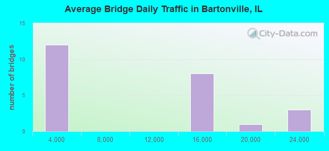
- 221,125Total average daily traffic
- 22,263Total average daily truck traffic
- National Bridge Inventory (NBI) Registered Bridges for Bartonville
- No street view available for this location
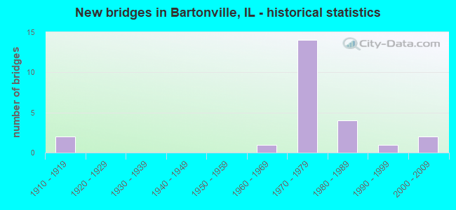
- New bridges - historical statistics
- 21910-1919
- 11960-1969
- 141970-1979
- 41980-1989
- 11990-1999
- 22000-2009
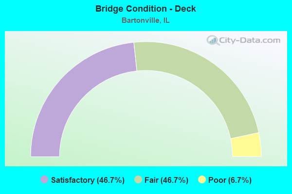
- Bridge Condition - Deck
- 46.7%Satisfactory
- 46.7%Fair
- 6.7%Poor
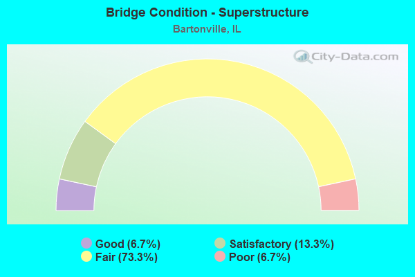
- Bridge Condition - Superstructure
- 6.7%Good
- 13.3%Satisfactory
- 73.3%Fair
- 6.7%Poor
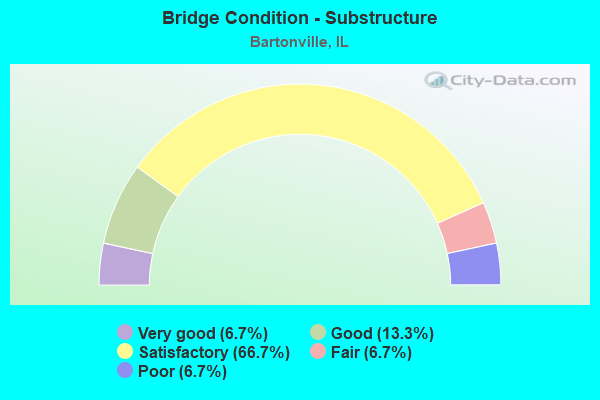
- Bridge Condition - Substructure
- 6.7%Very good
- 13.3%Good
- 66.7%Satisfactory
- 6.7%Fair
- 6.7%Poor
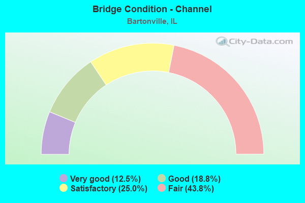
- Bridge Condition - Channel
- 12.5%Very good
- 18.8%Good
- 25.0%Satisfactory
- 43.8%Fair
Find on map >> Show street view
Structure Number: 720127, Location: 0.5 MI N OF US 24 (Lat: 40.660597, Lng: -89.648983), Route carried "on" structure: Interstate 474, Year Built: 1978, Status: Open, Structure Length: 35.48m (116.40ft), Average Daily Traffic: 14,850 (year 2021), Truck Traffic: 13%, Average Future Daily Traffic: 15,134 (year 2032), Design Load: HS 20+Mod, Features Intersected: KICKAPOO CR,RD,UPRR
Minimum Vertical Clearance: 30+ m (98+ ft), Kilometerpoint: 10.541, Lanes on structure: 2, Lanes under structure: 2, Base Highway Network: Yes, Owner: State Highway Agency, Approaching Roadway Width: 12.8m (42.0ft), Skew: 6 degrees, Material/Design: Steel continuous, Design/Construction: Stringer/Multi-beam, Number Of Spans In Main Unit: 11, Length of Maximum Span: 45.4m (149.0ft), Curb-To-Curb Width: 11.7m (38.4ft), Out-to-Out Width: 12.8m (42.0ft)
Condition: Deck: Fair, Superstructure: Fair, Substructure: Satisfactory, Channel: Fair, Operating Rating: 50.2 metric tons, Method Used To Determine Operating Rating: Load Factor (LF) rating reported by rating factor (RF) method using MS18 loading, Inventory Rating: 30.1 metric tons, Method Used To Determine Inventory Rating: Load Factor (LF) rating reported by rating factor (RF) method using MS18 loading, Structural Evaluation: Somewhat better than minimum adequacy, Deck Geometry: Equal to present minimum criteria, Underclear: Superior to present desirable criteria, Waterway Adequacy: Superior to present desirable criteria, Approach Roadway Alignment: Equal to present minimum criteria, Designated Inspection Frequency: Every 24 months, Inspection Date: November 2021, Deck Structure Type: Concrete Cast-file-Place, Wearing Surface/Protective System: Wearing Surface: Latex Concrete
Find on map >> Show street view
Structure Number: 720128, Location: 0.5 MI N OF US 24 (Lat: 40.660536, Lng: -89.648872), Route carried "on" structure: Interstate 474, Year Built: 1978, Status: Open, Structure Length: 32.64m (107.09ft), Average Daily Traffic: 14,850 (year 2021), Truck Traffic: 13%, Average Future Daily Traffic: 15,134 (year 2032), Design Load: HS 20+Mod, Features Intersected: KICKAPOO CR,RD,UPRR
Minimum Vertical Clearance: 30+ m (98+ ft), Kilometerpoint: 10.589, Lanes on structure: 2, Lanes under structure: 2, Base Highway Network: Yes, Owner: State Highway Agency, Approaching Roadway Width: 12.8m (42.0ft), Skew: 6 degrees, Material/Design: Steel continuous, Design/Construction: Stringer/Multi-beam, Number Of Spans In Main Unit: 10, Length of Maximum Span: 43.0m (141.1ft), Curb-To-Curb Width: 11.7m (38.4ft), Out-to-Out Width: 12.8m (42.0ft)
Condition: Deck: Fair, Superstructure: Fair, Substructure: Satisfactory, Channel: Fair, Operating Rating: 51.8 metric tons, Method Used To Determine Operating Rating: Load Factor (LF) rating reported by rating factor (RF) method using MS18 loading, Inventory Rating: 31.1 metric tons, Method Used To Determine Inventory Rating: Load Factor (LF) rating reported by rating factor (RF) method using MS18 loading, Structural Evaluation: Somewhat better than minimum adequacy, Deck Geometry: Equal to present minimum criteria, Underclear: Superior to present desirable criteria, Waterway Adequacy: Superior to present desirable criteria, Approach Roadway Alignment: Equal to present minimum criteria, Designated Inspection Frequency: Every 24 months, Inspection Date: November 2021, Deck Structure Type: Concrete Cast-file-Place, Wearing Surface/Protective System: Wearing Surface: Latex Concrete
Find on map >> Show street view
Structure Number: 720129, Location: 0.5 MI S OF PEORIA (Lat: 40.656639, Lng: -89.643753), Route carried "on" structure: Interstate 474, Year Built: 1978, Status: Open, Structure Length: 6.58m (21.59ft), Average Daily Traffic: 14,850 (year 2021), Truck Traffic: 13%, Average Future Daily Traffic: 15,824 (year 2032), Design Load: HS 20+Mod, Features Intersected: US 24 (S. ADAMS ST.)
Minimum Vertical Clearance: 30+ m (98+ ft), Kilometerpoint: 11.394, Lanes on structure: 3, Lanes under structure: 7, Base Highway Network: Yes, Owner: State Highway Agency, Approaching Roadway Width: 17.1m (56.1ft), Material/Design: Steel continuous, Design/Construction: Stringer/Multi-beam, Number Of Spans In Main Unit: 4, Length of Maximum Span: 21.3m (69.9ft), Curb-To-Curb Width: 13.9m (45.6ft), Out-to-Out Width: 15.0m (49.2ft)
Condition: Deck: Fair, Superstructure: Fair, Substructure: Satisfactory, Operating Rating: 73.5 metric tons, Method Used To Determine Operating Rating: Load Factor (LF) rating reported by rating factor (RF) method using MS18 loading, Inventory Rating: 44.1 metric tons, Method Used To Determine Inventory Rating: Load Factor (LF) rating reported by rating factor (RF) method using MS18 loading, Structural Evaluation: Somewhat better than minimum adequacy, Deck Geometry: Meets minimum limits, Underclear: Somewhat better than minimum adequacy, Approach Roadway Alignment: Equal to present minimum criteria, Designated Inspection Frequency: Every 24 months, Inspection Date: November 2021, Deck Structure Type: Concrete Cast-file-Place, Wearing Surface/Protective System: Wearing Surface: Latex Concrete
Find on map >> Show street view
Structure Number: 72013, Location: 0.5 MI S OF PEORIA (Lat: 40.656525, Lng: -89.643639), Route carried "on" structure: Interstate 474, Year Built: 1978, Status: Open, Structure Length: 6.58m (21.59ft), Average Daily Traffic: 13,900 (year 2021), Truck Traffic: 13%, Average Future Daily Traffic: 15,824 (year 2032), Design Load: HS 20+Mod, Features Intersected: US 24 (S. ADAMS ST.)
Minimum Vertical Clearance: 30+ m (98+ ft), Kilometerpoint: 11.426, Lanes on structure: 2, Lanes under structure: 6, Base Highway Network: Yes, Owner: State Highway Agency, Approaching Roadway Width: 12.8m (42.0ft), Material/Design: Steel continuous, Design/Construction: Stringer/Multi-beam, Number Of Spans In Main Unit: 4, Length of Maximum Span: 21.3m (69.9ft), Curb-To-Curb Width: 11.8m (38.7ft), Out-to-Out Width: 12.9m (42.3ft)
Condition: Deck: Satisfactory, Superstructure: Fair, Substructure: Satisfactory, Operating Rating: 82.3 metric tons, Method Used To Determine Operating Rating: Load Factor (LF) rating reported by rating factor (RF) method using MS18 loading, Inventory Rating: 47.3 metric tons, Method Used To Determine Inventory Rating: Load Factor (LF) rating reported by rating factor (RF) method using MS18 loading, Structural Evaluation: Somewhat better than minimum adequacy, Deck Geometry: Equal to present minimum criteria, Underclear: Somewhat better than minimum adequacy, Approach Roadway Alignment: Equal to present minimum criteria, Designated Inspection Frequency: Every 24 months, Inspection Date: November 2021, Deck Structure Type: Concrete Cast-file-Place, Wearing Surface/Protective System: Wearing Surface: Latex Concrete
Find on map >> Show street view
Structure Number: 720131, Location: .25 MI S OF US 24 (Lat: 40.655472, Lng: -89.642572), Route carried "on" structure: Interstate 474, Year Built: 1978, Status: Open, Structure Length: 23.53m (77.20ft), Average Daily Traffic: 13,900 (year 2021), Truck Traffic: 13%, Average Future Daily Traffic: 15,824 (year 2032), Design Load: HS 20+Mod, Features Intersected: KICKAPOO CR,TZPR RR
Minimum Vertical Clearance: 30+ m (98+ ft), Kilometerpoint: 11.651, Lanes on structure: 2, Base Highway Network: Yes, Owner: State Highway Agency, Approaching Roadway Width: 12.8m (42.0ft), Skew: 3 degrees, Material/Design: Steel continuous, Design/Construction: Stringer/Multi-beam, Number Of Spans In Main Unit: 8, Length of Maximum Span: 50.9m (167.0ft), Curb-To-Curb Width: 15.1m (49.5ft), Out-to-Out Width: 16.2m (53.1ft)
Condition: Deck: Satisfactory, Superstructure: Fair, Substructure: Satisfactory, Channel: Good, Operating Rating: 65.8 metric tons, Method Used To Determine Operating Rating: Load Factor (LF) rating reported by rating factor (RF) method using MS18 loading, Inventory Rating: 39.2 metric tons, Method Used To Determine Inventory Rating: Load Factor (LF) rating reported by rating factor (RF) method using MS18 loading, Structural Evaluation: Somewhat better than minimum adequacy, Deck Geometry: Superior to present desirable criteria, Underclear: Superior to present desirable criteria, Waterway Adequacy: Superior to present desirable criteria, Approach Roadway Alignment: Equal to present minimum criteria, Designated Inspection Frequency: Every 24 months, Inspection Date: November 2021, Deck Structure Type: Concrete Cast-file-Place, Wearing Surface/Protective System: Wearing Surface: Latex Concrete
Find on map >> Show street view
Structure Number: 720132, Location: .25 MI S OF US 24 (Lat: 40.655561, Lng: -89.642661), Route carried "on" structure: Interstate 474, Year Built: 1978, Status: Open, Structure Length: 26.24m (86.09ft), Average Daily Traffic: 13,900 (year 2021), Truck Traffic: 13%, Average Future Daily Traffic: 15,824 (year 2032), Design Load: HS 20+Mod, Features Intersected: KICKAPOO CR,TZPR RR
Minimum Vertical Clearance: 30+ m (98+ ft), Kilometerpoint: 11.635, Lanes on structure: 2, Base Highway Network: Yes, Owner: State Highway Agency, Approaching Roadway Width: 12.8m (42.0ft), Skew: 3 degrees, Material/Design: Steel continuous, Design/Construction: Stringer/Multi-beam, Number Of Spans In Main Unit: 9, Length of Maximum Span: 50.9m (167.0ft), Curb-To-Curb Width: 11.6m (38.1ft), Out-to-Out Width: 12.6m (41.3ft)
Condition: Deck: Satisfactory, Superstructure: Fair, Substructure: Satisfactory, Channel: Good, Operating Rating: 59.0 metric tons, Method Used To Determine Operating Rating: Load Factor (LF) rating reported by rating factor (RF) method using MS18 loading, Inventory Rating: 30.8 metric tons, Method Used To Determine Inventory Rating: Load Factor (LF) rating reported by rating factor (RF) method using MS18 loading, Structural Evaluation: Somewhat better than minimum adequacy, Deck Geometry: Equal to present minimum criteria, Underclear: Meets minimum limits, Waterway Adequacy: Superior to present desirable criteria, Approach Roadway Alignment: Equal to present minimum criteria, Designated Inspection Frequency: Every 24 months, Inspection Date: November 2021, Deck Structure Type: Concrete Cast-file-Place, Wearing Surface/Protective System: Wearing Surface: Latex Concrete
Find on map >> Show street view
Structure Number: 720134, Location: .5 MI E OF MCKINLEY (Lat: 40.654344, Lng: -89.647486), Route carried "on" structure: US 24, Year Built: 1980, Status: Open, Structure Length: 12.92m (42.39ft), Average Daily Traffic: 23,400 (year 2021), Truck Traffic: 7%, Average Future Daily Traffic: 28,886 (year 2032), Design Load: HS 20, Features Intersected: KICKAPOO CREEK
Minimum Vertical Clearance: 30+ m (98+ ft), Kilometerpoint: 202.128, Lanes on structure: 6, Base Highway Network: Yes, Owner: State Highway Agency, Approaching Roadway Width: 34.7m (113.8ft), Skew: 30 degrees, Material/Design: Prestressed concrete, Design/Construction: Box Beam or Girders - Multiple, Number Of Spans In Main Unit: 2, Number Of Approach Spans: 4, Length of Maximum Span: 26.5m (86.9ft), Curb or Sidewalk Widths: Left: 0.0m, Right: 1.5m (4.9ft), Curb-To-Curb Width: 26.1m (85.6ft), Out-to-Out Width: 33.9m (111.2ft)
Condition: Deck: Fair, Superstructure: Fair, Substructure: Fair, Channel: Fair, Operating Rating: 65.8 metric tons, Method Used To Determine Operating Rating: Load Factor (LF) rating reported by rating factor (RF) method using MS18 loading, Inventory Rating: 40.5 metric tons, Method Used To Determine Inventory Rating: Load Factor (LF) rating reported by rating factor (RF) method using MS18 loading, Structural Evaluation: Somewhat better than minimum adequacy, Deck Geometry: Equal to present minimum criteria, Waterway Adequacy: Equal to present minimum criteria, Approach Roadway Alignment: Equal to present minimum criteria, Designated Inspection Frequency: Every 24 months, Inspection Date: March 2021, Deck Structure Type: Concrete Precast Panels, Wearing Surface/Protective System: Wearing Surface: Bituminous, Membrane: Built-up
Find on map >> Show street view
Structure Number: 723119, Location: SE-21-T8NR7E (Lat: 40.656444, Lng: -89.706531), Route carried "on" structure: Other road , Year Built: 1987, Status: Open, Structure Length: 6.98m (22.90ft), Average Daily Traffic: 2,500 (year 2018), Truck Traffic: 6%, Average Future Daily Traffic: 2,814 (year 2032), Design Load: HS 20, Features Intersected: E BR LAMARSH CR, Facility Carried by Structure: SMITHVILLE RD
Minimum Vertical Clearance: 30+ m (98+ ft), Kilometerpoint: 5.697, Lanes on structure: 2, Owner: County Highway Agency, Approaching Roadway Width: 11.0m (36.1ft), Skew: 1 degrees, Material/Design: Prestressed concrete, Design/Construction: Stringer/Multi-beam, Number Of Spans In Main Unit: 3, Length of Maximum Span: 23.5m (77.1ft), Curb-To-Curb Width: 9.1m (29.9ft), Out-to-Out Width: 10.1m (33.1ft)
Condition: Deck: Satisfactory, Superstructure: Satisfactory, Substructure: Satisfactory, Channel: Satisfactory, Operating Rating: 44.4 metric tons, Method Used To Determine Operating Rating: Assigned rating based on Load Factor Design (LFD) reported by rating factor (RF) using MS18 loading, Inventory Rating: 32.4 metric tons, Method Used To Determine Inventory Rating: Assigned rating based on Load Factor Design (LFD) reported by rating factor (RF) using MS18 loading, Structural Evaluation: Equal to present minimum criteria, Deck Geometry: Meets minimum limits, Waterway Adequacy: Superior to present desirable criteria, Approach Roadway Alignment: Better than present minimum criteria, Designated Inspection Frequency: Every 24 months, Inspection Date: September 2020, Deck Structure Type: Concrete Cast-file-Place, Wearing Surface/Protective System: Deck Protection: Epoxy Coated Reinforcing
Find on map >> Show street view
Structure Number: 723142, Location: SW QTR 13 LIMESTONE (Lat: 40.669864, Lng: -89.655911), Route carried "on" structure: Other road , Year Built: 2001, Status: Open, Structure Length: 0.91m (2.99ft), Average Daily Traffic: 1,750 (year 2017), Truck Traffic: 8%, Average Future Daily Traffic: 2,283 (year 2032), Features Intersected: TRIB. OF KICKAPOO CR, Facility Carried by Structure: CREEK ROAD
Minimum Vertical Clearance: 30+ m (98+ ft), Kilometerpoint: 6.148, Lanes on structure: 2, Owner: County Highway Agency, Approaching Roadway Width: 6.6m (21.7ft), Skew: 3 degrees, Material/Design: Steel, Design/Construction: Culvert, Number Of Spans In Main Unit: 3, Length of Maximum Span: 1.5m (4.9ft)
Condition: Channel: Satisfactory, Culverts: Satisfactory, Operating Rating: 89.1 metric tons, Method Used To Determine Operating Rating: Load Factor (LF) rating reported by rating factor (RF) method using MS18 loading, Inventory Rating: 89.1 metric tons, Method Used To Determine Inventory Rating: Load Factor (LF) rating reported by rating factor (RF) method using MS18 loading, Structural Evaluation: Equal to present minimum criteria, Waterway Adequacy: Somewhat better than minimum adequacy, Approach Roadway Alignment: Somewhat better than minimum adequacy, Designated Inspection Frequency: Every 24 months, Inspection Date: September 2020
Find on map >> Show street view
Structure Number: 723145, Location: SEC 34 LIMESTONE TWP (Lat: 40.632075, Lng: -89.698692), Route carried "on" structure: County highway , Year Built: 2008, Status: Open, Structure Length: 6.40m (21.00ft), Average Daily Traffic: 3,800 (year 2018), Truck Traffic: 3%, Average Future Daily Traffic: 3,452 (year 2032), Design Load: HS 20, Features Intersected: BR LA MARSH CREEK, Facility Carried by Structure: LANCASTER ROAD
Minimum Vertical Clearance: 30+ m (98+ ft), Kilometerpoint: 8.626, Lanes on structure: 2, Owner: County Highway Agency, Approaching Roadway Width: 6.1m (20.0ft), Skew: 1 degrees, Material/Design: Prestressed concrete, Design/Construction: Box Beam or Girders - Multiple, Number Of Spans In Main Unit: 3, Length of Maximum Span: 21.1m (69.2ft), Curb-To-Curb Width: 12.8m (42.0ft), Out-to-Out Width: 12.8m (42.0ft)
Condition: Deck: Fair, Superstructure: Good, Substructure: Very good, Channel: Good, Operating Rating: 44.1 metric tons, Method Used To Determine Operating Rating: Assigned rating based on Load Factor Design (LFD) reported by rating factor (RF) using MS18 loading, Inventory Rating: 32.4 metric tons, Method Used To Determine Inventory Rating: Assigned rating based on Load Factor Design (LFD) reported by rating factor (RF) using MS18 loading, Structural Evaluation: Better than present minimum criteria, Deck Geometry: Equal to present minimum criteria, Waterway Adequacy: Superior to present desirable criteria, Approach Roadway Alignment: Equal to present desirable criteria, Designated Inspection Frequency: Every 24 months, Inspection Date: September 2020, Deck Structure Type: Concrete Precast Panels, Wearing Surface/Protective System: Wearing Surface: Integral Concrete
Find on map >> Show street view
Structure Number: 725507, Location: NC1NENE114 33 T8NR7E (Lat: 40.638028, Lng: -89.702989), Route carried "on" structure: County highway , Year Built: 1980, Status: Open, Structure Length: 3.57m (11.71ft), Average Daily Traffic: 1,200 (year 2017), Truck Traffic: 2%, Average Future Daily Traffic: 1,062 (year 2032), Design Load: HS 20, Features Intersected: BR LA MARSH CREEK, Facility Carried by Structure: PFEIFFER RD-TR 25
Minimum Vertical Clearance: 30+ m (98+ ft), Kilometerpoint: 1.336, Lanes on structure: 2, Owner: Town or Township Highway Agency, Approaching Roadway Width: 9.1m (29.9ft), Skew: 2 degrees, Material/Design: Prestressed concrete, Design/Construction: Box Beam or Girders - Multiple, Number Of Spans In Main Unit: 3, Length of Maximum Span: 11.0m (36.1ft), Curb-To-Curb Width: 8.5m (27.9ft), Out-to-Out Width: 9.3m (30.5ft)
Condition: Deck: Fair, Superstructure: Fair, Substructure: Poor, Channel: Satisfactory, Operating Rating: 43.4 metric tons, Method Used To Determine Operating Rating: Load Factor (LF) rating reported by rating factor (RF) method using MS18 loading, Inventory Rating: 16.2 metric tons, Method Used To Determine Inventory Rating: Load Factor (LF) rating reported by rating factor (RF) method using MS18 loading, Structural Evaluation: Meets minimum limits, Deck Geometry: Somewhat better than minimum adequacy, Waterway Adequacy: Equal to present desirable criteria, Approach Roadway Alignment: Equal to present minimum criteria, Designated Inspection Frequency: Every 24 months, Inspection Date: September 2021, Deck Structure Type: Concrete Precast Panels, Wearing Surface/Protective System: Wearing Surface: Bituminous
Find on map >> Show street view
Structure Number: 725509, Location: NW-16-T8NR8E (Lat: 40.676561, Lng: -89.713478), Route carried "on" structure: County highway , Year Built: 1982, Status: Open, Structure Length: 0.67m (2.20ft), Average Daily Traffic: 350 (year 2017), Truck Traffic: 6%, Average Future Daily Traffic: 372 (year 2032), Design Load: HS 20, Features Intersected: E BR LAMARSH CR, Facility Carried by Structure: MIDDLE RD (RELOC)
Minimum Vertical Clearance: 30+ m (98+ ft), Kilometerpoint: 1.400, Lanes on structure: 2, Owner: Town or Township Highway Agency, Approaching Roadway Width: 6.1m (20.0ft), Material/Design: Concrete, Design/Construction: Culvert, Number Of Spans In Main Unit: 2, Length of Maximum Span: 2.4m (7.9ft)
Condition: Channel: Satisfactory, Culverts: Satisfactory, Operating Rating: 54.1 metric tons, Method Used To Determine Operating Rating: Field evaluation and documented engineering judgment, Inventory Rating: 32.4 metric tons, Method Used To Determine Inventory Rating: Field evaluation and documented engineering judgment, Structural Evaluation: Equal to present minimum criteria, Waterway Adequacy: Equal to present minimum criteria, Approach Roadway Alignment: Somewhat better than minimum adequacy, Designated Inspection Frequency: Every 24 months, Inspection Date: September 2020
Find on map >> Show street view
Structure Number: 725701, Location: NLINE NW1/4 10T7NR7E (Lat: 40.609044, Lng: -89.694722), Route carried "on" structure: County highway , Year Built: 1966, Status: Open, Structure Length: 3.02m (9.91ft), Average Daily Traffic: 275 (year 2017), Truck Traffic: 7%, Average Future Daily Traffic: 425 (year 2032), Design Load: HS 15, Features Intersected: LA MARSH CREEK, Facility Carried by Structure: TUSCARORA RD-TR 25
Minimum Vertical Clearance: 30+ m (98+ ft), Kilometerpoint: 2.865, Lanes on structure: 2, Owner: Town or Township Highway Agency, Approaching Roadway Width: 8.2m (26.9ft), Skew: 2 degrees, Material/Design: Concrete continuous, Design/Construction: Slab, Number Of Spans In Main Unit: 3, Length of Maximum Span: 11.0m (36.1ft), Curb-To-Curb Width: 7.3m (24.0ft), Out-to-Out Width: 8.6m (28.2ft)
Condition: Deck: Satisfactory, Superstructure: Satisfactory, Substructure: Good, Channel: Fair, Operating Rating: 50.9 metric tons, Method Used To Determine Operating Rating: Allowable Stress (AS) rating reported by rating factor (RF) method using MS18 loading, Inventory Rating: 30.5 metric tons, Method Used To Determine Inventory Rating: Allowable Stress (AS) rating reported by rating factor (RF) method using MS18 loading, Structural Evaluation: Equal to present minimum criteria, Deck Geometry: Somewhat better than minimum adequacy, Waterway Adequacy: Equal to present desirable criteria, Approach Roadway Alignment: Equal to present minimum criteria, Designated Inspection Frequency: Every 24 months, Inspection Date: September 2021, Deck Structure Type: Concrete Cast-file-Place
Find on map >> Show street view
Structure Number: 726051, Location: NEAR SE CNR 34 T8R7 (Lat: 40.625439, Lng: -89.680478), Route carried "on" structure: Other road , Year Built: 1979, Status: Open, Structure Length: 1.34m (4.40ft), Average Daily Traffic: 1,400 (year 2017), Truck Traffic: 4%, Average Future Daily Traffic: 1,274 (year 2032), Design Load: HS 20, Features Intersected: BR OF LAMARSH CR, Facility Carried by Structure: AIRPORT ROAD
Minimum Vertical Clearance: 30+ m (98+ ft), Kilometerpoint: 7.242, Lanes on structure: 2, Owner: County Highway Agency, Approaching Roadway Width: 6.7m (22.0ft), Skew: 3 degrees, Material/Design: Prestressed concrete, Design/Construction: Box Beam or Girders - Multiple, Number Of Spans In Main Unit: 1, Length of Maximum Span: 12.8m (42.0ft), Curb-To-Curb Width: 9.6m (31.5ft), Out-to-Out Width: 9.9m (32.5ft)
Condition: Deck: Poor, Superstructure: Poor, Substructure: Satisfactory, Channel: Fair, Operating Rating: 60.3 metric tons, Method Used To Determine Operating Rating: Load Factor (LF) rating reported by rating factor (RF) method using MS18 loading, Inventory Rating: 36.0 metric tons, Method Used To Determine Inventory Rating: Load Factor (LF) rating reported by rating factor (RF) method using MS18 loading, Structural Evaluation: Meets minimum limits, Deck Geometry: Somewhat better than minimum adequacy, Waterway Adequacy: Better than present minimum criteria, Approach Roadway Alignment: Somewhat better than minimum adequacy, Designated Inspection Frequency: Every 24 months, Inspection Date: September 2021, Deck Structure Type: Concrete Precast Panels, Wearing Surface/Protective System: Wearing Surface: Bituminous, Membrane: Built-up
Find on map >> Show street view
Structure Number: 726053, Location: S. OF FAI 474 (Lat: 40.654819, Lng: -89.648967), Route carried "on" structure: City street , Year Built: 1993, Status: Open, Structure Length: 1.52m (4.99ft), Average Daily Traffic: 700 (year 2017), Truck Traffic: 4%, Average Future Daily Traffic: 1,009 (year 2032), Design Load: HS 20, Features Intersected: KICKAPOO CREEK TRIB, Facility Carried by Structure: TREASURE ST.
Minimum Vertical Clearance: 30+ m (98+ ft), Kilometerpoint: 0.579, Lanes on structure: 2, Owner: City or Municipal Highway Agency, Approaching Roadway Width: 9.1m (29.9ft), Skew: 1 degrees, Material/Design: Prestressed concrete, Design/Construction: Box Beam or Girders - Multiple, Number Of Spans In Main Unit: 1, Length of Maximum Span: 14.5m (47.6ft), Curb or Sidewalk Widths: Left: 1.2m (3.9ft), Right: 0.0m, Curb-To-Curb Width: 9.1m (29.9ft), Out-to-Out Width: 11.0m (36.1ft)
Condition: Deck: Fair, Superstructure: Fair, Substructure: Good, Channel: Fair, Operating Rating: 53.8 metric tons, Method Used To Determine Operating Rating: Assigned rating based on Load Factor Design (LFD) reported by rating factor (RF) using MS18 loading, Inventory Rating: 32.4 metric tons, Method Used To Determine Inventory Rating: Assigned rating based on Load Factor Design (LFD) reported by rating factor (RF) using MS18 loading, Structural Evaluation: Somewhat better than minimum adequacy, Deck Geometry: Equal to present minimum criteria, Waterway Adequacy: Better than present minimum criteria, Approach Roadway Alignment: Better than present minimum criteria, Designated Inspection Frequency: Every 24 months, Inspection Date: December 2021, Deck Structure Type: Concrete Precast Panels, Wearing Surface/Protective System: Wearing Surface: Bituminous
Find on map >> Show street view
Structure Number: 900108, Location: SW OF CREVE COEUR (Lat: 40.639194, Lng: -89.627489), Route carried "on" structure: Interstate 474, Year Built: 1975, Status: Open, Structure Length: 104.27m (342.09ft), Average Daily Traffic: 13,900 (year 2021), Truck Traffic: 13%, Average Future Daily Traffic: 15,824 (year 2032), Design Load: HS 20+Mod, Features Intersected: ILLINOIS RIVER
Minimum Vertical Clearance: 6.15m (20.18ft), Kilometerpoint: 13.840, Lanes on structure: 2, Lanes under structure: 2, Base Highway Network: Yes, Owner: State Highway Agency, Approaching Roadway Width: 12.2m (40.0ft), Navigation Control: Yes ( Vertical Clearance: 15.8m (51.8ft), Horizontal Clearance: 164.6m (540.0ft)), Material/Design: Steel continuous, Design/Construction: Truss - Thru, Number Of Spans In Main Unit: 3, Number Of Approach Spans: 13, Length of Maximum Span: 164.6m (540.0ft), Curb-To-Curb Width: 11.9m (39.0ft), Out-to-Out Width: 13.0m (42.7ft)
Condition: Deck: Satisfactory, Superstructure: Fair, Substructure: Satisfactory, Channel: Very good, Operating Rating: 48.9 metric tons, Method Used To Determine Operating Rating: Load Factor (LF) rating reported by rating factor (RF) method using MS18 loading, Inventory Rating: 29.2 metric tons, Method Used To Determine Inventory Rating: Load Factor (LF) rating reported by rating factor (RF) method using MS18 loading, Structural Evaluation: Somewhat better than minimum adequacy, Deck Geometry: Equal to present minimum criteria, Underclear: Superior to present desirable criteria, Waterway Adequacy: Equal to present desirable criteria, Approach Roadway Alignment: Equal to present desirable criteria, Designated Inspection Frequency: Every 24 months, Critical Feature Inspection Frequency: Every 24 months, Underwater Inspection Frequency: Every 60 months, Other Special Inspection Frequency: Every 6 months, Inspection Date: June 2021, Critical Feature Inspection Date: June 2021, Underwater Inspection Date: June 2021, Other Special Inspection Date: December 2021, Deck Structure Type: Concrete Cast-file-Place, Wearing Surface/Protective System: Wearing Surface: Latex Concrete, Membrane: Built-up
Find on map >> Show street view
Structure Number: 900109, Location: SW OF CREVE COEUR (Lat: 40.639308, Lng: -89.627622), Route carried "on" structure: Interstate 474, Year Built: 1975, Status: Open, Structure Length: 104.39m (342.49ft), Average Daily Traffic: 13,900 (year 2021), Truck Traffic: 13%, Average Future Daily Traffic: 15,824 (year 2032), Design Load: HS 20+Mod, Features Intersected: ILLINOIS RIVER
Minimum Vertical Clearance: 6.15m (20.18ft), Kilometerpoint: 13.824, Lanes on structure: 2, Lanes under structure: 2, Base Highway Network: Yes, Owner: State Highway Agency, Approaching Roadway Width: 12.2m (40.0ft), Navigation Control: Yes ( Vertical Clearance: 15.8m (51.8ft), Horizontal Clearance: 164.6m (540.0ft)), Material/Design: Steel continuous, Design/Construction: Truss - Thru, Number Of Spans In Main Unit: 3, Number Of Approach Spans: 13, Length of Maximum Span: 164.6m (540.0ft), Curb-To-Curb Width: 11.9m (39.0ft), Out-to-Out Width: 13.0m (42.7ft)
Condition: Deck: Satisfactory, Superstructure: Fair, Substructure: Satisfactory, Channel: Very good, Operating Rating: 48.9 metric tons, Method Used To Determine Operating Rating: Load Factor (LF) rating reported by rating factor (RF) method using MS18 loading, Inventory Rating: 29.2 metric tons, Method Used To Determine Inventory Rating: Load Factor (LF) rating reported by rating factor (RF) method using MS18 loading, Structural Evaluation: Somewhat better than minimum adequacy, Deck Geometry: Equal to present minimum criteria, Underclear: Superior to present desirable criteria, Waterway Adequacy: Equal to present desirable criteria, Approach Roadway Alignment: Equal to present desirable criteria, Designated Inspection Frequency: Every 24 months, Critical Feature Inspection Frequency: Every 24 months, Underwater Inspection Frequency: Every 60 months, Inspection Date: April 2021, Critical Feature Inspection Date: April 2021, Underwater Inspection Date: April 2021, Deck Structure Type: Concrete Cast-file-Place, Wearing Surface/Protective System: Wearing Surface: Latex Concrete, Membrane: Built-up
Find on map >> Show street view
Structure Number: AFILJLQN85821, Location: 0.2 MILES NORTH OF SOUTH (Lat: 40.658794, Lng: -89.704083), Route carried "on" structure: ServiceOther road , Year Built: 1970, Status: Open, Structure Length: 1.04m (3.41ft), Average Daily Traffic: 250 (year 2020), Average Future Daily Traffic: 300 (year 2040), Features Intersected: E BRANCH LAMARSH CREEK, Facility Carried by Structure: W MUNITIONS ROAD
Minimum Vertical Clearance: 30+ m (98+ ft), Kilometerpoint: 0.000, Lanes on structure: 2, Owner: Air Force, Approaching Roadway Width: 7.4m (24.3ft), Material/Design: Concrete, Design/Construction: Culvert, Number Of Spans In Main Unit: 3, Length of Maximum Span: 3.0m (9.8ft)
Condition: Channel: Fair, Culverts: Satisfactory, Operating Rating: 36.3 metric tons, Method Used To Determine Operating Rating: Field evaluation and documented engineering judgment, Inventory Rating: 32.7 metric tons, Method Used To Determine Inventory Rating: Field evaluation and documented engineering judgment, Structural Evaluation: Equal to present minimum criteria, Waterway Adequacy: Better than present minimum criteria, Approach Roadway Alignment: Equal to present desirable criteria, Designated Inspection Frequency: Every 24 months, Inspection Date: September 2020, Bridge Improvement Cost: $50,000, Roadway Improvement Cost: $5,000, Total Project Cost: $75,000
Find on map >> Show street view
Structure Number: 720127, Location: 0.5 MI N OF US 24 (Lat: 40.661386, Lng: -89.650125), Route carried "under" structure: Other road , Year Built: 1978, Structure Length: 0. m, Average Daily Traffic: 1,750 (year 2017), Truck Traffic: 8%, Features Intersected: KICKAPOO CR,RD,UPRR, Facility Carried by Structure: WB I-474
Minimum Vertical Clearance: 8.23m (27.00ft), Kilometerpoint: 7.129, Lanes on structure: 2, Lanes under structure: 2, Material/Design: Steel continuous, Design/Construction: Stringer/Multi-beam, Length of Maximum Span: 45.4m (149.0ft)
Find on map >> Show street view
Structure Number: 720128, Location: 0.5 MI N OF US 24 (Lat: 40.661239, Lng: -89.650031), Route carried "under" structure: Other road , Year Built: 1978, Structure Length: 0. m, Average Daily Traffic: 1,750 (year 2017), Truck Traffic: 8%, Features Intersected: KICKAPOO CR,RD,UPRR, Facility Carried by Structure: EB I-474
Minimum Vertical Clearance: 8.23m (27.00ft), Kilometerpoint: 7.145, Lanes on structure: 2, Lanes under structure: 2, Material/Design: Steel continuous, Design/Construction: Stringer/Multi-beam, Length of Maximum Span: 43.0m (141.1ft)
Find on map >> Show street view
Structure Number: 720129, Location: 0.5 MI S OF PEORIA (Lat: 40.656056, Lng: -89.644456), Route carried "under" structure: US 24, Year Built: 1978, Structure Length: 0. m, Average Daily Traffic: 23,400 (year 2021), Truck Traffic: 7%, Features Intersected: US 24 (S. ADAMS ST.), Facility Carried by Structure: EB I-474
Minimum Vertical Clearance: 5.08m (16.67ft), Kilometerpoint: 202.450, Lanes on structure: 3, Lanes under structure: 7, Material/Design: Steel continuous, Design/Construction: Stringer/Multi-beam, Length of Maximum Span: 21.3m (69.9ft)
Find on map >> Show street view
Structure Number: 72013, Location: 0.5 MI S OF PEORIA (Lat: 40.656786, Lng: -89.643514), Route carried "under" structure: Other road , Year Built: 1978, Structure Length: 0. m, Average Daily Traffic: 19,400 (year 2017), Truck Traffic: 8%, Features Intersected: US 24 (S. ADAMS ST.), Facility Carried by Structure: WB I-474
Minimum Vertical Clearance: 5.31m (17.42ft), Kilometerpoint: 22.707, Lanes on structure: 2, Lanes under structure: 6, Material/Design: Steel continuous, Design/Construction: Stringer/Multi-beam, Length of Maximum Span: 21.3m (69.9ft)
Find on map >> Show street view
Structure Number: 7299, Location: SE-24-T8NR7E (Lat: 40.654097, Lng: -89.647928), Route carried "under" structure: US 24, Year Built: 1912, Structure Length: 0. m, Average Daily Traffic: 23,400 (year 2021), Truck Traffic: 7%, Features Intersected: ADAMS ST - FAP 317, Facility Carried by Structure: CNW (175563L)
Minimum Vertical Clearance: 5.36m (17.59ft), Kilometerpoint: 202.080, Lanes under structure: 4, Material/Design: Steel, Design/Construction: Stringer/Multi-beam, Length of Maximum Span: 10.1m (33.1ft)
Find on map >> Show street view
Structure Number: 729908, Location: SEC 25 LIMESTONE TWP (Lat: 40.663567, Lng: -89.651511), Route carried "under" structure: Other road , Year Built: 1912, Structure Length: 0. m, Average Daily Traffic: 1,750 (year 2017), Truck Traffic: 8%, Features Intersected: KICKAPOO CREEK ROAD, Facility Carried by Structure: C&NW RR (175564T)
Minimum Vertical Clearance: 3.81m (12.50ft), Kilometerpoint: 6.888, Lanes under structure: 2, Material/Design: Steel, Design/Construction: Girder and Floorbeam System, Length of Maximum Span: 11.6m (38.1ft)