Bridge Statistics for Battle Mountain, Nevada (NV)
Condition, Traffic, Stress, Structural Evaluation, Project Costs
- National Bridge Inventory (NBI) Statistics
- 21Number of bridges
- 184ft / 56.3mTotal length
- $1,018,000Total costs
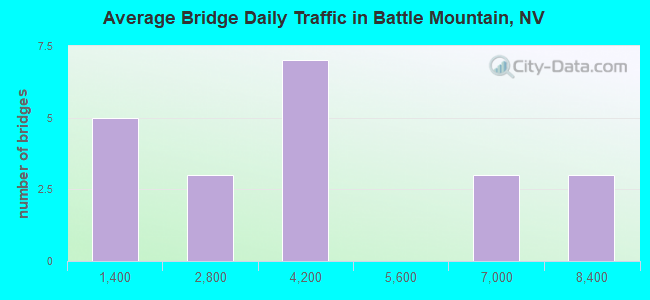
- 72,024Total average daily traffic
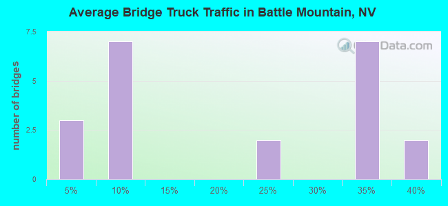
- 16,349Total average daily truck traffic
- National Bridge Inventory (NBI) Registered Bridges for Battle Mountain
- No street view available for this location
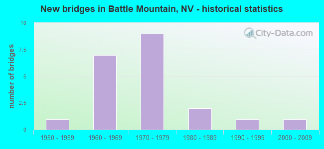
- New bridges - historical statistics
- 11950-1959
- 71960-1969
- 91970-1979
- 21980-1989
- 11990-1999
- 12000-2009
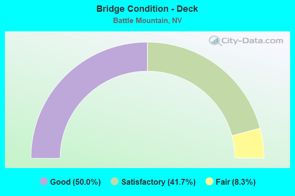
- Bridge Condition - Deck
- 50.0%Good
- 41.7%Satisfactory
- 8.3%Fair
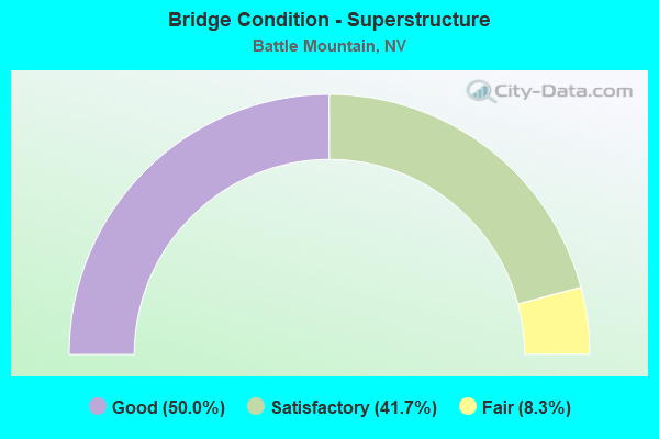
- Bridge Condition - Superstructure
- 50.0%Good
- 41.7%Satisfactory
- 8.3%Fair
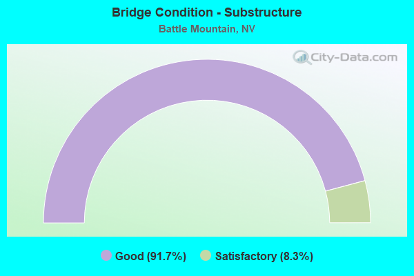
- Bridge Condition - Substructure
- 91.7%Good
- 8.3%Satisfactory
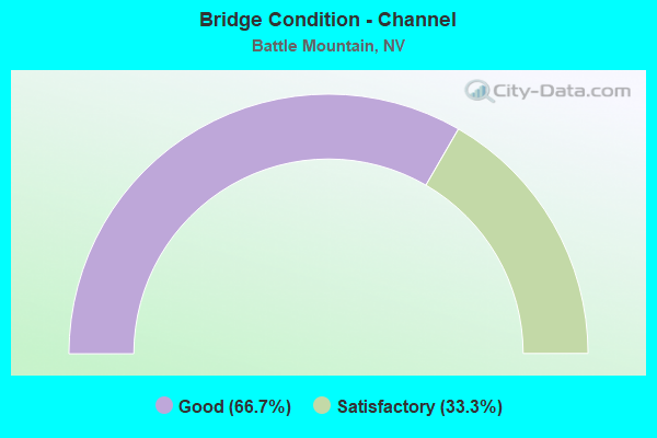
- Bridge Condition - Channel
- 66.7%Good
- 33.3%Satisfactory
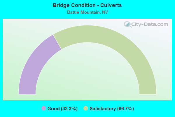
- Bridge Condition - Culverts
- 33.3%Good
- 66.7%Satisfactory
Find on map >> Show street view
Structure Number: B 34, Location: EAST OF BATTLE MOUNTAIN (Lat: 40.630719, Lng: -116.922444), Route carried "on" structure: State highway 304, Year Built: 1994, Status: Open, Structure Length: 0.79m (2.59ft), Average Daily Traffic: 1,800 (year 2017), Truck Traffic: 9%, Average Future Daily Traffic: 1,989 (year 2040), Design Load: HS 20, Features Intersected: REESE RVR
Minimum Vertical Clearance: 30+ m (98+ ft), Kilometerpoint: 4.543, Lanes on structure: 2, Owner: State Highway Agency, Approaching Roadway Width: 12.2m (40.0ft), Material/Design: Concrete, Design/Construction: Culvert, Number Of Spans In Main Unit: 3, Length of Maximum Span: 2.4m (7.9ft)
Condition: Channel: Good, Culverts: Good, Operating Rating: 73.1 metric tons, Method Used To Determine Operating Rating: Load Factor (LF), Inventory Rating: 43.7 metric tons, Method Used To Determine Inventory Rating: Load Factor (LF), Structural Evaluation: Better than present minimum criteria, Waterway Adequacy: Equal to present desirable criteria, Approach Roadway Alignment: Equal to present desirable criteria, Designated Inspection Frequency: Every 48 months, Inspection Date: July 2021
Find on map >> Show street view
Structure Number: B 325, Location: SOUTH OF BATTLE MTN (Lat: 40.583253, Lng: -116.927892), Route carried "on" structure: County highway , Year Built: 1982, Status: Open, Structure Length: 1.40m (4.59ft), Average Daily Traffic: 120 (year 2017), Truck Traffic: 1%, Average Future Daily Traffic: 133 (year 2040), Design Load: HS 20+Mod, Features Intersected: REESE RVR, Facility Carried by Structure: JENKINS RD
Minimum Vertical Clearance: 30+ m (98+ ft), Kilometerpoint: 0.000, Lanes on structure: 2, Owner: County Highway Agency, Approaching Roadway Width: 7.9m (25.9ft), Material/Design: Concrete, Design/Construction: Slab, Number Of Spans In Main Unit: 1, Length of Maximum Span: 13.7m (44.9ft), Curb-To-Curb Width: 7.9m (25.9ft), Out-to-Out Width: 8.8m (28.9ft)
Condition: Deck: Satisfactory, Superstructure: Satisfactory, Substructure: Good, Channel: Good, Operating Rating: 59.0 metric tons, Method Used To Determine Operating Rating: Load Factor (LF), Inventory Rating: 35.6 metric tons, Method Used To Determine Inventory Rating: Load Factor (LF), Structural Evaluation: Equal to present minimum criteria, Deck Geometry: Somewhat better than minimum adequacy, Waterway Adequacy: Equal to present desirable criteria, Approach Roadway Alignment: Equal to present desirable criteria, Designated Inspection Frequency: Every 24 months, Inspection Date: July 2021, Deck Structure Type: Concrete Cast-file-Place, Wearing Surface/Protective System: Wearing Surface: Bituminous, Deck Protection: Epoxy Coated Reinforcing
Find on map >> Show street view
Structure Number: B 88, Location: BATTLE MOUNTAIN (Lat: 40.625522, Lng: -116.922303), Route carried "on" structure: Interstate 80, Year Built: 1976, Status: Open, Structure Length: 1.55m (5.09ft), Average Daily Traffic: 7,600 (year 2017), Truck Traffic: 31%, Average Future Daily Traffic: 8,397 (year 2040), Design Load: HS 20+Mod, Features Intersected: W REESE RVR
Minimum Vertical Clearance: 30+ m (98+ ft), Kilometerpoint: 374.533, Lanes on structure: 4, Base Highway Network: Yes, Owner: State Highway Agency, Approaching Roadway Width: 23.2m (76.1ft), Material/Design: Concrete, Design/Construction: Culvert, Number Of Spans In Main Unit: 4, Length of Maximum Span: 3.7m (12.1ft)
Condition: Channel: Satisfactory, Culverts: Satisfactory, Operating Rating: 60.9 metric tons, Method Used To Determine Operating Rating: Load Factor (LF), Inventory Rating: 36.6 metric tons, Method Used To Determine Inventory Rating: Load Factor (LF), Structural Evaluation: Equal to present minimum criteria, Waterway Adequacy: Equal to present desirable criteria, Approach Roadway Alignment: Equal to present desirable criteria, Designated Inspection Frequency: Every 48 months, Inspection Date: July 2021
Find on map >> Show street view
Structure Number: B 881, Location: BATTLE MOUNTAIN (Lat: 40.627464, Lng: -116.927003), Route carried "on" structure: Interstate 80, Year Built: 1976, Status: Open, Structure Length: 1.55m (5.09ft), Average Daily Traffic: 7,600 (year 2017), Truck Traffic: 31%, Average Future Daily Traffic: 8,397 (year 2040), Design Load: HS 20+Mod, Features Intersected: E REESE RVR
Minimum Vertical Clearance: 30+ m (98+ ft), Kilometerpoint: 374.990, Lanes on structure: 4, Base Highway Network: Yes, Owner: State Highway Agency, Approaching Roadway Width: 23.2m (76.1ft), Material/Design: Concrete, Design/Construction: Culvert, Number Of Spans In Main Unit: 4, Length of Maximum Span: 3.7m (12.1ft)
Condition: Channel: Good, Culverts: Satisfactory, Operating Rating: 75.1 metric tons, Method Used To Determine Operating Rating: Load Factor (LF), Inventory Rating: 45.0 metric tons, Method Used To Determine Inventory Rating: Load Factor (LF), Structural Evaluation: Equal to present minimum criteria, Waterway Adequacy: Equal to present desirable criteria, Approach Roadway Alignment: Equal to present desirable criteria, Designated Inspection Frequency: Every 48 months, Inspection Date: July 2021
Find on map >> Show street view
Structure Number: B1013, Location: NORTHWEST OF BATTLE MTN. (Lat: 40.651047, Lng: -116.930064), Route carried "on" structure: Alternate State highway 806, Year Built: 1962, Status: Open, Structure Length: 0.79m (2.59ft), Average Daily Traffic: 240 (year 2017), Truck Traffic: 7%, Average Future Daily Traffic: 400 (year 2040), Design Load: HS 20, Features Intersected: REESE RVR
Minimum Vertical Clearance: 30+ m (98+ ft), Kilometerpoint: 1.267, Lanes on structure: 2, Owner: State Highway Agency, Approaching Roadway Width: 7.9m (25.9ft), Material/Design: Concrete, Design/Construction: Culvert, Number Of Spans In Main Unit: 2, Length of Maximum Span: 3.7m (12.1ft)
Condition: Channel: Good, Culverts: Good, Operating Rating: 55.3 metric tons, Method Used To Determine Operating Rating: Load Factor (LF), Inventory Rating: 33.1 metric tons, Method Used To Determine Inventory Rating: Load Factor (LF), Structural Evaluation: Better than present minimum criteria, Waterway Adequacy: Equal to present desirable criteria, Approach Roadway Alignment: Equal to present desirable criteria, Designated Inspection Frequency: Every 48 months, Inspection Date: July 2021
Find on map >> Show street view
Structure Number: B1014, Location: NORTH OF BATTLE MOUNTAIN (Lat: 40.667939, Lng: -116.931297), Route carried "on" structure: State highway 806, Year Built: 2000, Status: Open, Structure Length: 5.12m (16.80ft), Average Daily Traffic: 240 (year 2017), Truck Traffic: 7%, Average Future Daily Traffic: 400 (year 2040), Design Load: HS 20, Features Intersected: HUMBOLDT RIVER
Minimum Vertical Clearance: 30+ m (98+ ft), Kilometerpoint: 3.140, Lanes on structure: 2, Owner: State Highway Agency, Approaching Roadway Width: 10.8m (35.4ft), Skew: 4 degrees, Material/Design: Prestressed concrete continuous, Design/Construction: Box Beam or Girders - Multiple, Number Of Spans In Main Unit: 3, Length of Maximum Span: 19.8m (65.0ft), Curb-To-Curb Width: 10.8m (35.4ft), Out-to-Out Width: 11.7m (38.4ft)
Condition: Deck: Good, Superstructure: Good, Substructure: Good, Channel: Good, Operating Rating: 65.9 metric tons, Method Used To Determine Operating Rating: Load Factor (LF), Inventory Rating: 39.5 metric tons, Method Used To Determine Inventory Rating: Load Factor (LF), Structural Evaluation: Better than present minimum criteria, Deck Geometry: Better than present minimum criteria, Waterway Adequacy: Better than present minimum criteria, Approach Roadway Alignment: Equal to present desirable criteria, Length Of Structure Improvement: 5.04m (16.54ft), Designated Inspection Frequency: Every 48 months, Underwater Inspection Frequency: Every 48 months, Inspection Date: July 2021, Underwater Inspection Date: July 2019, Bridge Improvement Cost: $405,000, Roadway Improvement Cost: $41,000, Total Project Cost: $608,000, Deck Structure Type: Concrete Cast-file-Place, Wearing Surface/Protective System: Wearing Surface: Monolithic Concrete
Find on map >> Show street view
Structure Number: B1097, Location: EAST OF BATTLE MOUNTAIN (Lat: 40.626583, Lng: -116.924958), Route carried "on" structure: Interstate 80, Year Built: 1975, Status: Open, Structure Length: 1.65m (5.41ft), Average Daily Traffic: 7,600 (year 2017), Truck Traffic: 31%, Average Future Daily Traffic: 8,397 (year 2040), Design Load: HS 20+Mod, Features Intersected: REESE RVR
Minimum Vertical Clearance: 30+ m (98+ ft), Kilometerpoint: 374.761, Lanes on structure: 4, Base Highway Network: Yes, Owner: State Highway Agency, Approaching Roadway Width: 11.6m (38.1ft), Skew: 2 degrees, Material/Design: Concrete, Design/Construction: Culvert, Number Of Spans In Main Unit: 4, Length of Maximum Span: 4.0m (13.1ft)
Condition: Channel: Satisfactory, Culverts: Satisfactory, Operating Rating: 75.1 metric tons, Method Used To Determine Operating Rating: Load Factor (LF), Inventory Rating: 45.0 metric tons, Method Used To Determine Inventory Rating: Load Factor (LF), Structural Evaluation: Equal to present minimum criteria, Waterway Adequacy: Equal to present desirable criteria, Approach Roadway Alignment: Equal to present desirable criteria, Designated Inspection Frequency: Every 48 months, Inspection Date: July 2021
Find on map >> Show street view
Structure Number: B1851, Location: BATTLE MOUNTAIN (Lat: 40.647206, Lng: -116.926142), Route carried "on" structure: Other road , Year Built: 1986, Status: Open, Structure Length: 0.85m (2.79ft), Average Daily Traffic: 24 (year 2017), Truck Traffic: 5%, Average Future Daily Traffic: 27 (year 2040), Design Load: HS 20, Features Intersected: REESE RVR OVERFLOW, Facility Carried by Structure: OLD RIVER RD
Minimum Vertical Clearance: 30+ m (98+ ft), Kilometerpoint: 0.000, Lanes on structure: 1, Owner: County Highway Agency, Approaching Roadway Width: 6.1m (20.0ft), Material/Design: Steel, Design/Construction: Stringer/Multi-beam, Number Of Spans In Main Unit: 1, Length of Maximum Span: 7.3m (24.0ft), Curb-To-Curb Width: 7.4m (24.3ft), Out-to-Out Width: 7.5m (24.6ft)
Condition: Deck: Fair, Superstructure: Fair, Substructure: Good, Channel: Good, Operating Rating: 66.2 metric tons, Method Used To Determine Operating Rating: Load Factor (LF), Inventory Rating: 39.5 metric tons, Method Used To Determine Inventory Rating: Load Factor (LF), Structural Evaluation: Somewhat better than minimum adequacy, Deck Geometry: Equal to present minimum criteria, Waterway Adequacy: Better than present minimum criteria, Approach Roadway Alignment: Equal to present desirable criteria, Length Of Structure Improvement: 1.49m (4.89ft), Designated Inspection Frequency: Every 24 months, Inspection Date: July 2021, Bridge Improvement Cost: $122,000, Roadway Improvement Cost: $12,000, Total Project Cost: $182,000, Deck Structure Type: Steel plate, Wearing Surface/Protective System: Wearing Surface: Other
Find on map >> Show street view
Structure Number: I 810E, Location: EAST OF BATTLE MTN (Lat: 40.662911, Lng: -116.735133), Route carried "on" structure: Interstate 80, Year Built: 1962, Year Reconstructed: 1983, Status: Open, Structure Length: 2.87m (9.42ft), Average Daily Traffic: 3,500 (year 2017), Truck Traffic: 31%, Average Future Daily Traffic: 3,867 (year 2040), Design Load: HS 20+Mod, Features Intersected: ARGENTA EXIT 244
Minimum Vertical Clearance: 30+ m (98+ ft), Kilometerpoint: 393.728, Lanes on structure: 2, Lanes under structure: 2, Base Highway Network: Yes, Owner: State Highway Agency, Approaching Roadway Width: 11.6m (38.1ft), Material/Design: Concrete continuous, Design/Construction: Slab, Number Of Spans In Main Unit: 3, Length of Maximum Span: 10.7m (35.1ft), Curb-To-Curb Width: 11.6m (38.1ft), Out-to-Out Width: 13.1m (43.0ft)
Condition: Deck: Satisfactory, Superstructure: Satisfactory, Substructure: Good, Operating Rating: 74.4 metric tons, Method Used To Determine Operating Rating: Load Factor (LF), Inventory Rating: 44.4 metric tons, Method Used To Determine Inventory Rating: Load Factor (LF), Structural Evaluation: Equal to present minimum criteria, Deck Geometry: Equal to present minimum criteria, Underclear: High priority of corrective action, Approach Roadway Alignment: Equal to present desirable criteria, Designated Inspection Frequency: Every 24 months, Inspection Date: July 2021, Deck Structure Type: Concrete Cast-file-Place, Wearing Surface/Protective System: Wearing Surface: Bituminous, Membrane: Other
Find on map >> Show street view
Structure Number: I 810W, Location: EAST OF BATTLE MTN (Lat: 40.663156, Lng: -116.735289), Route carried "on" structure: Interstate 80, Year Built: 1962, Year Reconstructed: 1983, Status: Open, Structure Length: 2.87m (9.42ft), Average Daily Traffic: 3,500 (year 2017), Truck Traffic: 31%, Average Future Daily Traffic: 3,867 (year 2040), Design Load: HS 20+Mod, Features Intersected: ARGENTA EXIT 244
Minimum Vertical Clearance: 30+ m (98+ ft), Kilometerpoint: 393.728, Lanes on structure: 2, Lanes under structure: 2, Base Highway Network: Yes, Owner: State Highway Agency, Approaching Roadway Width: 11.6m (38.1ft), Material/Design: Concrete continuous, Design/Construction: Slab, Number Of Spans In Main Unit: 3, Length of Maximum Span: 10.7m (35.1ft), Curb-To-Curb Width: 11.6m (38.1ft), Out-to-Out Width: 13.1m (43.0ft)
Condition: Deck: Satisfactory, Superstructure: Satisfactory, Substructure: Satisfactory, Operating Rating: 74.4 metric tons, Method Used To Determine Operating Rating: Load Factor (LF), Inventory Rating: 44.4 metric tons, Method Used To Determine Inventory Rating: Load Factor (LF), Structural Evaluation: Equal to present minimum criteria, Deck Geometry: Equal to present minimum criteria, Underclear: High priority of corrective action, Approach Roadway Alignment: Equal to present desirable criteria, Designated Inspection Frequency: Every 24 months, Inspection Date: July 2021, Deck Structure Type: Concrete Cast-file-Place, Wearing Surface/Protective System: Wearing Surface: Bituminous, Membrane: Other
Find on map >> Show street view
Structure Number: I 877E, Location: WEST OF BATTLE MTN (Lat: 40.734100, Lng: -117.055319), Route carried "on" structure: Interstate 80, Year Built: 1963, Status: Open, Structure Length: 0.67m (2.20ft), Average Daily Traffic: 3,500 (year 2017), Truck Traffic: 37%, Average Future Daily Traffic: 3,867 (year 2040), Design Load: HS 20+Mod, Features Intersected: MOTE RD EXIT 222
Minimum Vertical Clearance: 30+ m (98+ ft), Kilometerpoint: 358.364, Lanes on structure: 2, Lanes under structure: 2, Base Highway Network: Yes, Owner: State Highway Agency, Approaching Roadway Width: 11.6m (38.1ft), Material/Design: Concrete, Design/Construction: Frame, Number Of Spans In Main Unit: 1, Length of Maximum Span: 6.1m (20.0ft), Curb-To-Curb Width: 11.6m (38.1ft), Out-to-Out Width: 13.1m (43.0ft)
Condition: Deck: Good, Superstructure: Good, Substructure: Good, Inventory Rating: 61.7 metric tons, Method Used To Determine Inventory Rating: Load Factor (LF), Structural Evaluation: Better than present minimum criteria, Deck Geometry: Equal to present minimum criteria, Underclear: High priority of corrective action, Approach Roadway Alignment: Equal to present desirable criteria, Designated Inspection Frequency: Every 24 months, Inspection Date: July 2021, Deck Structure Type: Concrete Cast-file-Place, Wearing Surface/Protective System: Membrane: Preformed Fabric
Find on map >> Show street view
Structure Number: I 877W, Location: WEST OF BATTLE MTN (Lat: 40.734572, Lng: -117.054642), Route carried "on" structure: Interstate 80, Year Built: 1963, Status: Open, Structure Length: 0.67m (2.20ft), Average Daily Traffic: 3,500 (year 2017), Truck Traffic: 37%, Average Future Daily Traffic: 3,867 (year 2040), Design Load: HS 20+Mod, Features Intersected: MOTE RD EXIT 222
Minimum Vertical Clearance: 30+ m (98+ ft), Kilometerpoint: 358.364, Lanes on structure: 2, Lanes under structure: 2, Base Highway Network: Yes, Owner: State Highway Agency, Approaching Roadway Width: 11.6m (38.1ft), Material/Design: Concrete, Design/Construction: Frame, Number Of Spans In Main Unit: 1, Length of Maximum Span: 6.1m (20.0ft), Curb-To-Curb Width: 11.6m (38.1ft), Out-to-Out Width: 13.1m (43.0ft)
Condition: Deck: Good, Superstructure: Good, Substructure: Good, Inventory Rating: 61.7 metric tons, Method Used To Determine Inventory Rating: Load Factor (LF), Structural Evaluation: Better than present minimum criteria, Deck Geometry: Equal to present minimum criteria, Underclear: High priority of corrective action, Approach Roadway Alignment: Equal to present desirable criteria, Designated Inspection Frequency: Every 24 months, Inspection Date: July 2021, Deck Structure Type: Concrete Cast-file-Place, Wearing Surface/Protective System: Membrane: Preformed Fabric
Find on map >> Show street view
Structure Number: I 878, Location: BATTLE MOUNTAIN (Lat: 40.654892, Lng: -116.956469), Route carried "on" structure: Business State highway 304, Year Built: 1976, Status: Open, Structure Length: 9.85m (32.32ft), Average Daily Traffic: 1,600 (year 2017), Truck Traffic: 9%, Average Future Daily Traffic: 1,768 (year 2040), Design Load: HS 20+Mod, Features Intersected: I 80
Minimum Vertical Clearance: 30+ m (98+ ft), Kilometerpoint: 370.494, Lanes on structure: 3, Lanes under structure: 4, Owner: State Highway Agency, Approaching Roadway Width: 12.2m (40.0ft), Skew: 2 degrees, Material/Design: Prestressed concrete continuous, Design/Construction: Box Beam or Girders - Single/Spread, Number Of Spans In Main Unit: 2, Length of Maximum Span: 48.8m (160.1ft), Curb or Sidewalk Widths: Left: 1.5m (4.9ft), Right: 0.0m, Curb-To-Curb Width: 14.6m (47.9ft), Out-to-Out Width: 17.3m (56.8ft)
Condition: Deck: Good, Superstructure: Good, Substructure: Good, Operating Rating: 74.7 metric tons, Method Used To Determine Operating Rating: Load Factor (LF), Inventory Rating: 40.8 metric tons, Method Used To Determine Inventory Rating: Load Factor (LF), Structural Evaluation: Better than present minimum criteria, Deck Geometry: Somewhat better than minimum adequacy, Underclear: Somewhat better than minimum adequacy, Approach Roadway Alignment: Equal to present desirable criteria, Designated Inspection Frequency: Every 24 months, Inspection Date: July 2021, Deck Structure Type: Concrete Cast-file-Place, Wearing Surface/Protective System: Wearing Surface: Bituminous, Membrane: Preformed Fabric
Find on map >> Show street view
Structure Number: I 879, Location: BATTLE MOUNTAIN (Lat: 40.635386, Lng: -116.944947), Route carried "on" structure: State highway 305, Year Built: 1976, Status: Open, Structure Length: 8.93m (29.30ft), Average Daily Traffic: 3,500 (year 2017), Truck Traffic: 23%, Average Future Daily Traffic: 3,867 (year 2040), Design Load: HS 20+Mod, Features Intersected: I 80
Minimum Vertical Clearance: 30+ m (98+ ft), Kilometerpoint: 372.758, Lanes on structure: 2, Lanes under structure: 4, Owner: State Highway Agency, Approaching Roadway Width: 11.0m (36.1ft), Material/Design: Prestressed concrete continuous, Design/Construction: Box Beam or Girders - Single/Spread, Number Of Spans In Main Unit: 2, Length of Maximum Span: 43.9m (144.0ft), Curb or Sidewalk Widths: Left: 1.5m (4.9ft), Right: 1.5m (4.9ft), Curb-To-Curb Width: 11.0m (36.1ft), Out-to-Out Width: 15.4m (50.5ft)
Condition: Deck: Good, Superstructure: Good, Substructure: Good, Inventory Rating: 38.8 metric tons, Method Used To Determine Inventory Rating: Load Factor (LF), Structural Evaluation: Better than present minimum criteria, Deck Geometry: Somewhat better than minimum adequacy, Underclear: Somewhat better than minimum adequacy, Approach Roadway Alignment: Equal to present desirable criteria, Designated Inspection Frequency: Every 24 months, Inspection Date: July 2021, Deck Structure Type: Concrete Cast-file-Place, Wearing Surface/Protective System: Wearing Surface: Bituminous, Membrane: Preformed Fabric
Find on map >> Show street view
Structure Number: I 882, Location: BATTLE MOUNTAIN (Lat: 40.622697, Lng: -116.914300), Route carried "on" structure: State highway 304, Year Built: 1976, Status: Open, Structure Length: 9.75m (31.99ft), Average Daily Traffic: 1,700 (year 2017), Truck Traffic: 9%, Average Future Daily Traffic: 1,878 (year 2040), Design Load: HS 20+Mod, Features Intersected: I 80
Minimum Vertical Clearance: 30+ m (98+ ft), Kilometerpoint: 375.754, Lanes on structure: 2, Lanes under structure: 4, Owner: State Highway Agency, Approaching Roadway Width: 12.2m (40.0ft), Skew: 6 degrees, Material/Design: Prestressed concrete continuous, Design/Construction: Box Beam or Girders - Single/Spread, Number Of Spans In Main Unit: 2, Length of Maximum Span: 48.8m (160.1ft), Curb or Sidewalk Widths: Left: 0.0m, Right: 1.5m (4.9ft), Curb-To-Curb Width: 14.6m (47.9ft), Out-to-Out Width: 16.9m (55.4ft)
Condition: Deck: Good, Superstructure: Good, Substructure: Good, Operating Rating: 71.1 metric tons, Method Used To Determine Operating Rating: Load Factor (LF), Inventory Rating: 40.8 metric tons, Method Used To Determine Inventory Rating: Load Factor (LF), Structural Evaluation: Better than present minimum criteria, Deck Geometry: Superior to present desirable criteria, Underclear: Somewhat better than minimum adequacy, Approach Roadway Alignment: Equal to present desirable criteria, Designated Inspection Frequency: Every 24 months, Inspection Date: July 2021, Deck Structure Type: Concrete Cast-file-Place, Wearing Surface/Protective System: Wearing Surface: Bituminous
Find on map >> Show street view
Structure Number: I 883E, Location: EAST OF BATTLE MTN (Lat: 40.696000, Lng: -116.557000), Route carried "on" structure: Interstate 80, Year Built: 1962, Year Reconstructed: 1983, Status: Open, Structure Length: 2.87m (9.42ft), Average Daily Traffic: 3,800 (year 2017), Truck Traffic: 31%, Average Future Daily Traffic: 4,199 (year 2040), Design Load: HS 20+Mod, Features Intersected: DUNPHY EXIT 254
Minimum Vertical Clearance: 30+ m (98+ ft), Kilometerpoint: 409.486, Lanes on structure: 2, Lanes under structure: 2, Base Highway Network: Yes, Owner: State Highway Agency, Approaching Roadway Width: 11.6m (38.1ft), Material/Design: Concrete continuous, Design/Construction: Slab, Number Of Spans In Main Unit: 3, Length of Maximum Span: 10.7m (35.1ft), Curb-To-Curb Width: 11.6m (38.1ft), Out-to-Out Width: 13.1m (43.0ft)
Condition: Deck: Satisfactory, Superstructure: Satisfactory, Substructure: Good, Operating Rating: 45.0 metric tons, Method Used To Determine Operating Rating: Load Factor (LF), Inventory Rating: 26.8 metric tons, Method Used To Determine Inventory Rating: Load Factor (LF), Structural Evaluation: Equal to present minimum criteria, Deck Geometry: Equal to present minimum criteria, Underclear: Meets minimum limits, Approach Roadway Alignment: Equal to present desirable criteria, Designated Inspection Frequency: Every 24 months, Inspection Date: July 2021, Deck Structure Type: Concrete Cast-file-Place, Wearing Surface/Protective System: Wearing Surface: Bituminous, Membrane: Other
Find on map >> Show street view
Structure Number: I 883W, Location: EAST OF BATTLE MTN (Lat: 40.696300, Lng: -116.557128), Route carried "on" structure: Interstate 80, Year Built: 1962, Year Reconstructed: 1983, Status: Open, Structure Length: 2.87m (9.42ft), Average Daily Traffic: 3,800 (year 2017), Truck Traffic: 31%, Average Future Daily Traffic: 4,199 (year 2040), Design Load: HS 20+Mod, Features Intersected: DUNPHY EXIT 254
Minimum Vertical Clearance: 30+ m (98+ ft), Kilometerpoint: 409.486, Lanes on structure: 2, Lanes under structure: 2, Base Highway Network: Yes, Owner: State Highway Agency, Approaching Roadway Width: 11.6m (38.1ft), Material/Design: Concrete continuous, Design/Construction: Slab, Number Of Spans In Main Unit: 3, Length of Maximum Span: 10.7m (35.1ft), Curb-To-Curb Width: 11.6m (38.1ft), Out-to-Out Width: 13.1m (43.0ft)
Condition: Deck: Satisfactory, Superstructure: Satisfactory, Substructure: Good, Operating Rating: 45.0 metric tons, Method Used To Determine Operating Rating: Load Factor (LF), Inventory Rating: 26.8 metric tons, Method Used To Determine Inventory Rating: Load Factor (LF), Structural Evaluation: Equal to present minimum criteria, Deck Geometry: Equal to present minimum criteria, Underclear: Meets minimum limits, Approach Roadway Alignment: Equal to present desirable criteria, Designated Inspection Frequency: Every 24 months, Inspection Date: July 2021, Deck Structure Type: Concrete Cast-file-Place, Wearing Surface/Protective System: Wearing Surface: Bituminous, Membrane: Other
Find on map >> Show street view
Structure Number: M 818B, Location: 33.85 Mi N. of US 50 (Lat: 39.943894, Lng: -117.146172), Route carried "on" structure: State highway 305, Year Built: 1959, Status: Open, Structure Length: 1.22m (4.00ft), Average Daily Traffic: 370 (year 2017), Truck Traffic: 23%, Average Future Daily Traffic: 409 (year 2040), Features Intersected: REESE RVR
Minimum Vertical Clearance: 30+ m (98+ ft), Kilometerpoint: 0.000, Lanes on structure: 2, Owner: State Highway Agency, Approaching Roadway Width: 8.0m (26.2ft), Skew: 3 degrees, Material/Design: Steel, Design/Construction: Culvert, Number Of Spans In Main Unit: 2, Length of Maximum Span: 5.5m (18.0ft)
Condition: Channel: Satisfactory, Culverts: Satisfactory, Structural Evaluation: Equal to present minimum criteria, Waterway Adequacy: Equal to present desirable criteria, Approach Roadway Alignment: Equal to present desirable criteria, Length Of Structure Improvement: 1.89m (6.20ft), Designated Inspection Frequency: Every 48 months, Inspection Date: August 2021, Bridge Improvement Cost: $152,000, Roadway Improvement Cost: $15,000, Total Project Cost: $228,000
Find on map >> Show street view
Structure Number: I 878, Location: BATTLE MOUNTAIN (Lat: 40.654892, Lng: -116.956469), Route carried "under" structure: Interstate 80, Year Built: 1976, Structure Length: 0. m, Average Daily Traffic: 6,210 (year 2009), Truck Traffic: 6%, Features Intersected: I 80, Facility Carried by Structure: SR304 FRONT ST
Minimum Vertical Clearance: 5.15m (16.90ft), Kilometerpoint: 370.494, Lanes on structure: 3, Lanes under structure: 4, Material/Design: Prestressed concrete continuous, Design/Construction: Box Beam or Girders - Single/Spread, Length of Maximum Span: 48.8m (160.1ft)
Find on map >> Show street view
Structure Number: I 879, Location: BATTLE MOUNTAIN (Lat: 40.635386, Lng: -116.944947), Route carried "under" structure: Interstate 80, Year Built: 1976, Structure Length: 0. m, Average Daily Traffic: 5,620 (year 2009), Truck Traffic: 4%, Features Intersected: I 80, Facility Carried by Structure: SR305 BROAD ST
Minimum Vertical Clearance: 5.36m (17.59ft), Kilometerpoint: 372.758, Lanes on structure: 2, Lanes under structure: 4, Material/Design: Prestressed concrete continuous, Design/Construction: Box Beam or Girders - Single/Spread, Length of Maximum Span: 43.9m (144.0ft)
Find on map >> Show street view
Structure Number: I 882, Location: BATTLE MOUNTAIN (Lat: 40.622697, Lng: -116.914300), Route carried "under" structure: Interstate 80, Year Built: 1976, Structure Length: 0. m, Average Daily Traffic: 6,200 (year 2009), Truck Traffic: 3%, Features Intersected: I 80, Facility Carried by Structure: SR304 FRONT ST
Minimum Vertical Clearance: 5.03m (16.50ft), Kilometerpoint: 375.754, Lanes on structure: 2, Lanes under structure: 4, Material/Design: Prestressed concrete continuous, Design/Construction: Box Beam or Girders - Single/Spread, Length of Maximum Span: 48.8m (160.1ft)