Bridge Statistics for Belleville, Arkansas (AR)
Condition, Traffic, Stress, Structural Evaluation, Project Costs
- National Bridge Inventory (NBI) Statistics
- 11Number of bridges
- 92ft / 27.9mTotal length
- $1,047,000Total costs
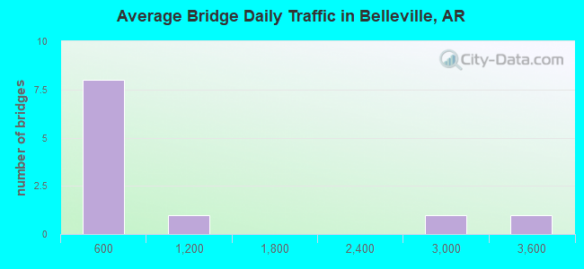
- 9,642Total average daily traffic
- 744Total average daily truck traffic
- 9,819Total future (year 2007) average daily traffic
- National Bridge Inventory (NBI) Registered Bridges for Belleville
- No street view available for this location
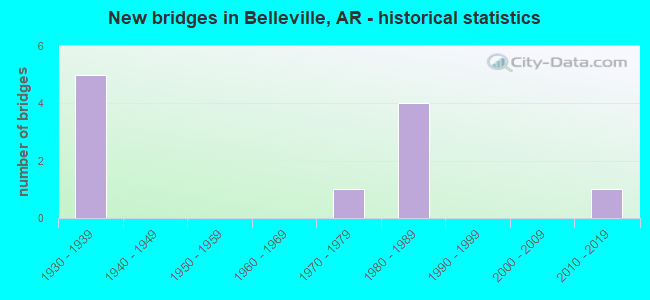
- New bridges - historical statistics
- 51930-1939
- 11970-1979
- 41980-1989
- 12010-2019
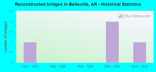
- Reconstructed bridges - Historical Statistics
- 11970-1979
- 01980-1989
- 01990-1999
- 22000-2009
- 12010-2019
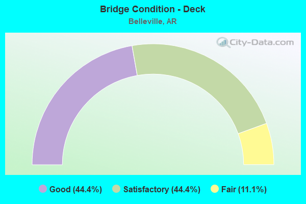
- Bridge Condition - Deck
- 44.4%Good
- 44.4%Satisfactory
- 11.1%Fair
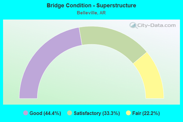
- Bridge Condition - Superstructure
- 44.4%Good
- 33.3%Satisfactory
- 22.2%Fair
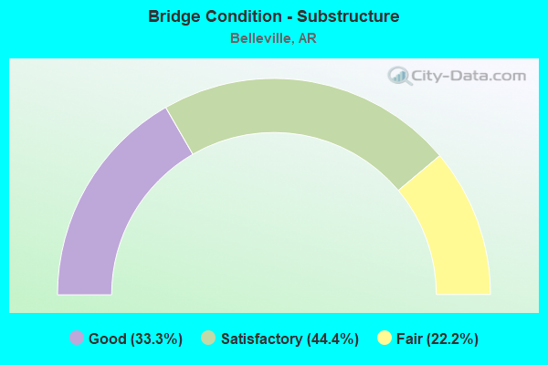
- Bridge Condition - Substructure
- 33.3%Good
- 44.4%Satisfactory
- 22.2%Fair
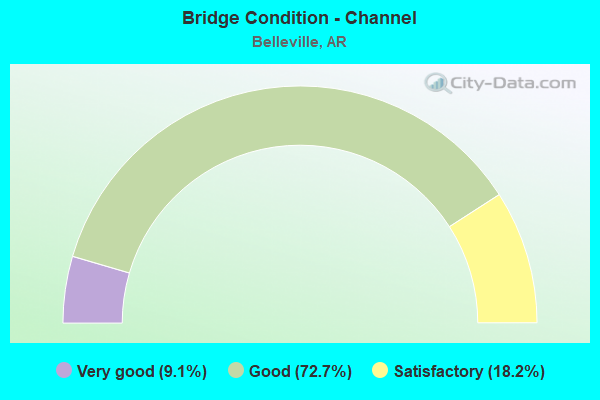
- Bridge Condition - Channel
- 9.1%Very good
- 72.7%Good
- 18.2%Satisfactory
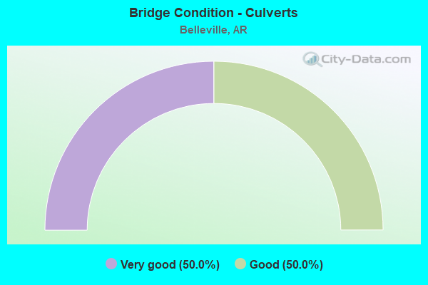
- Bridge Condition - Culverts
- 50.0%Very good
- 50.0%Good
Find on map >> Show street view
Structure Number: 4235, Location: 1.8 M S JCT CO RD 18 & 19 (Lat: 35.069889, Lng: -93.488192), Route carried "on" structure: County highway 18, Year Built: 1974, Status: Open, Structure Length: 6.19m (20.31ft), Average Daily Traffic: 490 (year 2018), Truck Traffic: 1%, Average Future Daily Traffic: 120 (year 2007), Design Load: H 20, Features Intersected: Petit Jean River, Facility Carried by Structure: Bailey Branch Rd.
Minimum Vertical Clearance: 30+ m (98+ ft), Kilometerpoint: 10.944, Lanes on structure: 2, Owner: County Highway Agency, Approaching Roadway Width: 8.5m (27.9ft), Material/Design: Steel, Design/Construction: Stringer/Multi-beam, Number Of Spans In Main Unit: 4, Length of Maximum Span: 24.4m (80.1ft), Curb-To-Curb Width: 8.0m (26.2ft), Out-to-Out Width: 9.1m (29.9ft)
Condition: Deck: Satisfactory, Superstructure: Satisfactory, Substructure: Good, Channel: Good, Operating Rating: 41.7 metric tons, Method Used To Determine Operating Rating: Load Factor (LF), Inventory Rating: 25.4 metric tons, Method Used To Determine Inventory Rating: Load Factor (LF), Structural Evaluation: Equal to present minimum criteria, Deck Geometry: Somewhat better than minimum adequacy, Waterway Adequacy: Equal to present desirable criteria, Approach Roadway Alignment: Better than present minimum criteria, Designated Inspection Frequency: Every 24 months, Critical Feature Inspection Frequency: Every 24 months, Inspection Date: Febuary 2021, Deck Structure Type: Concrete Cast-file-Place, Wearing Surface/Protective System: Wearing Surface: Monolithic Concrete
Find on map >> Show street view
Structure Number: 4515, Location: 5.35 MI W JCT SH 27 (Lat: 35.128533, Lng: -93.426981), Route carried "on" structure: County highway 23, Year Built: 1984, Status: Open, Structure Length: 8.53m (27.99ft), Average Daily Traffic: 470 (year 2018), Truck Traffic: 6%, Average Future Daily Traffic: 179 (year 2007), Design Load: H 20, Features Intersected: Spring Creek, Facility Carried by Structure: Spring Creek Rd
Minimum Vertical Clearance: 30+ m (98+ ft), Kilometerpoint: 8.608, Lanes on structure: 2, Owner: County Highway Agency, Approaching Roadway Width: 6.5m (21.3ft), Skew: 6 degrees, Material/Design: Concrete, Design/Construction: Slab, Number Of Spans In Main Unit: 8, Length of Maximum Span: 10.7m (35.1ft), Curb-To-Curb Width: 7.3m (24.0ft), Out-to-Out Width: 8.2m (26.9ft)
Condition: Deck: Good, Superstructure: Good, Substructure: Good, Channel: Good, Operating Rating: 49.9 metric tons, Method Used To Determine Operating Rating: Load Factor (LF), Inventory Rating: 29.9 metric tons, Method Used To Determine Inventory Rating: Load Factor (LF), Structural Evaluation: Better than present minimum criteria, Deck Geometry: Meets minimum limits, Waterway Adequacy: Equal to present desirable criteria, Approach Roadway Alignment: Equal to present desirable criteria, Designated Inspection Frequency: Every 24 months, Critical Feature Inspection Frequency: Every 24 months, Inspection Date: Febuary 2021, Deck Structure Type: Concrete Cast-file-Place, Wearing Surface/Protective System: Wearing Surface: Monolithic Concrete
Find on map >> Show street view
Structure Number: 4619, Location: 2.8 MI W JCT SH307&CR 23 (Lat: 35.130442, Lng: -93.483108), Route carried "on" structure: County highway 23, Year Built: 1989, Status: Open, Structure Length: 3.66m (12.01ft), Average Daily Traffic: 429 (year 2018), Truck Traffic: 1%, Average Future Daily Traffic: 65 (year 2008), Design Load: HS 20, Features Intersected: East Cedar Creek, Facility Carried by Structure: Cedar Creek Rd
Minimum Vertical Clearance: 30+ m (98+ ft), Kilometerpoint: 13.885, Lanes on structure: 2, Owner: County Highway Agency, Approaching Roadway Width: 7.1m (23.3ft), Material/Design: Steel, Design/Construction: Stringer/Multi-beam, Number Of Spans In Main Unit: 3, Length of Maximum Span: 12.2m (40.0ft), Curb-To-Curb Width: 7.3m (24.0ft), Out-to-Out Width: 8.2m (26.9ft)
Condition: Deck: Good, Superstructure: Good, Substructure: Good, Channel: Good, Operating Rating: 54.4 metric tons, Method Used To Determine Operating Rating: Load Factor (LF), Inventory Rating: 32.7 metric tons, Method Used To Determine Inventory Rating: Load Factor (LF), Structural Evaluation: Better than present minimum criteria, Deck Geometry: Meets minimum limits, Waterway Adequacy: Equal to present desirable criteria, Approach Roadway Alignment: Equal to present desirable criteria, Designated Inspection Frequency: Every 24 months, Critical Feature Inspection Frequency: Every 24 months, Inspection Date: Febuary 2021, Deck Structure Type: Concrete Cast-file-Place, Wearing Surface/Protective System: Wearing Surface: Monolithic Concrete
Find on map >> Show street view
Structure Number: 17746, Location: 0.31 MI S JCT 441 & 43 (Lat: 35.125892, Lng: -93.393889), Route carried "on" structure: County highway 441, Year Built: 1930, Year Reconstructed: 1982, Status: Open, Structure Length: 0.98m (3.22ft), Average Daily Traffic: 10 (year 2018), Truck Traffic: 1%, Average Future Daily Traffic: 12 (year 2007), Features Intersected: PRAIRIE CREEK, Facility Carried by Structure: Mule Skinner Rd
Minimum Vertical Clearance: 30+ m (98+ ft), Kilometerpoint: 0.531, Lanes on structure: 1, Owner: County Highway Agency, Approaching Roadway Width: 3.5m (11.5ft), Material/Design: Steel, Design/Construction: Stringer/Multi-beam, Number Of Spans In Main Unit: 3, Length of Maximum Span: 3.7m (12.1ft), Curb-To-Curb Width: 3.4m (11.2ft), Out-to-Out Width: 4.0m (13.1ft)
Condition: Deck: Satisfactory, Superstructure: Fair, Substructure: Fair, Channel: Satisfactory, Operating Rating: 54.4 metric tons, Method Used To Determine Operating Rating: Allowable Stress (AS), Inventory Rating: 32.7 metric tons, Method Used To Determine Inventory Rating: Allowable Stress (AS), Structural Evaluation: Somewhat better than minimum adequacy, Deck Geometry: High priority of corrective action, Waterway Adequacy: Equal to present minimum criteria, Approach Roadway Alignment: High priority of corrective action, Length Of Structure Improvement: 0.98m (3.22ft), Designated Inspection Frequency: Every 24 months, Critical Feature Inspection Frequency: Every 24 months, Inspection Date: March 2021, Roadway Improvement Cost: $131,000,000, Total Project Cost: $19,000, Deck Structure Type: Concrete Cast-file-Place, Wearing Surface/Protective System: Wearing Surface: Monolithic Concrete
Find on map >> Show street view
Structure Number: 18353, Location: 3.30 MI W JCT SH 27 (Lat: 35.129839, Lng: -93.393989), Route carried "on" structure: County highway 43, Year Built: 1930, Status: Open, Structure Length: 0.67m (2.20ft), Average Daily Traffic: 535 (year 2018), Truck Traffic: 1%, Average Future Daily Traffic: 186 (year 2007), Features Intersected: E Fork Prairie Creek, Facility Carried by Structure: Old Booneville Rd
Minimum Vertical Clearance: 30+ m (98+ ft), Kilometerpoint: 5.309, Lanes on structure: 2, Owner: County Highway Agency, Approaching Roadway Width: 6.5m (21.3ft), Material/Design: Concrete, Design/Construction: Slab, Number Of Spans In Main Unit: 1, Length of Maximum Span: 6.7m (22.0ft), Curb-To-Curb Width: 6.2m (20.3ft), Out-to-Out Width: 6.7m (22.0ft)
Condition: Deck: Satisfactory, Superstructure: Satisfactory, Substructure: Satisfactory, Channel: Satisfactory, Operating Rating: 39.9 metric tons, Method Used To Determine Operating Rating: Load Factor (LF), Inventory Rating: 24.5 metric tons, Method Used To Determine Inventory Rating: Load Factor (LF), Structural Evaluation: Equal to present minimum criteria, Deck Geometry: High priority of corrective action, Waterway Adequacy: Equal to present minimum criteria, Approach Roadway Alignment: Equal to present minimum criteria, Length Of Structure Improvement: 1.37m (4.49ft), Designated Inspection Frequency: Every 24 months, Critical Feature Inspection Frequency: Every 24 months, Inspection Date: March 2021, Roadway Improvement Cost: $109,000, Total Project Cost: $202,000, Deck Structure Type: Concrete Cast-file-Place, Wearing Surface/Protective System: Wearing Surface: Bituminous
Find on map >> Show street view
Structure Number: 18354, Location: 3.53 MI W JCT SH 27 (Lat: 35.130169, Lng: -93.397500), Route carried "on" structure: County highway 43, Year Built: 1930, Status: Open, Structure Length: 1.28m (4.20ft), Average Daily Traffic: 535 (year 2018), Truck Traffic: 1%, Average Future Daily Traffic: 186 (year 2007), Features Intersected: Prairie Creek, Facility Carried by Structure: Old Booneville Rd
Minimum Vertical Clearance: 30+ m (98+ ft), Kilometerpoint: 5.681, Lanes on structure: 2, Owner: County Highway Agency, Approaching Roadway Width: 6.1m (20.0ft), Material/Design: Concrete, Design/Construction: Slab, Number Of Spans In Main Unit: 2, Length of Maximum Span: 6.4m (21.0ft), Curb-To-Curb Width: 6.1m (20.0ft), Out-to-Out Width: 7.0m (23.0ft)
Condition: Deck: Satisfactory, Superstructure: Satisfactory, Substructure: Fair, Channel: Good, Operating Rating: 54.4 metric tons, Method Used To Determine Operating Rating: Load Factor (LF), Inventory Rating: 32.7 metric tons, Method Used To Determine Inventory Rating: Load Factor (LF), Structural Evaluation: Somewhat better than minimum adequacy, Deck Geometry: High priority of corrective action, Waterway Adequacy: Equal to present minimum criteria, Approach Roadway Alignment: Equal to present desirable criteria, Designated Inspection Frequency: Every 24 months, Critical Feature Inspection Frequency: Every 24 months, Inspection Date: March 2021, Deck Structure Type: Concrete Cast-file-Place, Wearing Surface/Protective System: Wearing Surface: Bituminous
Find on map >> Show street view
Structure Number: 19834, Location: .4 MI SW JCT SH 10 (Lat: 35.088578, Lng: -93.453239), Route carried "on" structure: City street 54230, Year Built: 1982, Year Reconstructed: 2011, Status: Open, Structure Length: 0.76m (2.49ft), Average Daily Traffic: 200 (year 2018), Truck Traffic: 1%, Average Future Daily Traffic: 409 (year 2007), Features Intersected: Russell Branch, Facility Carried by Structure: South Road
Minimum Vertical Clearance: 30+ m (98+ ft), Kilometerpoint: 0.708, Lanes on structure: 1, Owner: City or Municipal Highway Agency, Approaching Roadway Width: 6.1m (20.0ft), Material/Design: Concrete, Design/Construction: Channel Beam, Number Of Spans In Main Unit: 1, Length of Maximum Span: 7.6m (24.9ft), Curb-To-Curb Width: 4.1m (13.5ft), Out-to-Out Width: 4.4m (14.4ft)
Condition: Deck: Good, Superstructure: Good, Substructure: Satisfactory, Channel: Very good, Operating Rating: 50.8 metric tons, Method Used To Determine Operating Rating: Load Factor (LF), Inventory Rating: 30.8 metric tons, Method Used To Determine Inventory Rating: Load Factor (LF), Structural Evaluation: Equal to present minimum criteria, Deck Geometry: High priority of replacement, Waterway Adequacy: Somewhat better than minimum adequacy, Approach Roadway Alignment: Better than present minimum criteria, Length Of Structure Improvement: 1.46m (4.79ft), Designated Inspection Frequency: Every 24 months, Critical Feature Inspection Frequency: Every 24 months, Inspection Date: March 2020, Roadway Improvement Cost: $109,000, Total Project Cost: $207,000, Deck Structure Type: Concrete Precast Panels, Wearing Surface/Protective System: Wearing Surface: Monolithic Concrete
Find on map >> Show street view
Structure Number: 20384, Location: 2.0 MI E JCT SH 307 (Lat: 35.109139, Lng: -93.407081), Route carried "on" structure: County highway 42, Year Built: 1985, Year Reconstructed: 2016, Status: Open, Structure Length: 3.11m (10.20ft), Average Daily Traffic: 688 (year 2018), Truck Traffic: 1%, Average Future Daily Traffic: 112 (year 2007), Features Intersected: Spring Creek, Facility Carried by Structure: Old Bellville Rd
Minimum Vertical Clearance: 30+ m (98+ ft), Kilometerpoint: 13.564, Lanes on structure: 2, Owner: County Highway Agency, Approaching Roadway Width: 5.5m (18.0ft), Material/Design: Steel continuous, Design/Construction: Orthotropic, Number Of Spans In Main Unit: 4, Length of Maximum Span: 7.6m (24.9ft), Curb-To-Curb Width: 5.6m (18.4ft), Out-to-Out Width: 5.9m (19.4ft)
Condition: Deck: Fair, Superstructure: Fair, Substructure: Satisfactory, Channel: Good, Operating Rating: 42.6 metric tons, Method Used To Determine Operating Rating: Load Factor (LF), Inventory Rating: 25.4 metric tons, Method Used To Determine Inventory Rating: Load Factor (LF), Structural Evaluation: Somewhat better than minimum adequacy, Deck Geometry: High priority of replacement, Waterway Adequacy: Equal to present minimum criteria, Approach Roadway Alignment: High priority of corrective action, Length Of Structure Improvement: 3.11m (10.20ft), Designated Inspection Frequency: Every 24 months, Critical Feature Inspection Frequency: Every 24 months, Inspection Date: Febuary 2021, Critical Feature Inspection Date: Febuary 2022, Total Project Cost: $88,000, Deck Structure Type: Steel plate, Wearing Surface/Protective System: Wearing Surface: Monolithic Concrete
Find on map >> Show street view
Structure Number: 23446, Location: 4.61 M NW Jct SH80 & CR18 (Lat: 35.054000, Lng: -93.485053), Route carried "on" structure: County highway 18, Year Built: 2011, Status: Open, Structure Length: 1.20m (3.94ft), Average Daily Traffic: 490 (year 2018), Truck Traffic: 11%, Average Future Daily Traffic: 132 (year 2007), Features Intersected: Riley Creek, Facility Carried by Structure: Bailey Branch Rd.
Minimum Vertical Clearance: 30+ m (98+ ft), Kilometerpoint: 7.419, Lanes on structure: 2, Owner: County Highway Agency, Approaching Roadway Width: 5.5m (18.0ft), Skew: 3 degrees, Material/Design: Steel continuous, Design/Construction: Stringer/Multi-beam, Number Of Spans In Main Unit: 2, Length of Maximum Span: 5.5m (18.0ft), Curb-To-Curb Width: 6.1m (20.0ft), Out-to-Out Width: 6.4m (21.0ft)
Condition: Deck: Good, Superstructure: Good, Substructure: Satisfactory, Channel: Good, Operating Rating: 54.4 metric tons, Method Used To Determine Operating Rating: Load Factor (LF), Inventory Rating: 32.7 metric tons, Method Used To Determine Inventory Rating: Load Factor (LF), Structural Evaluation: Equal to present minimum criteria, Deck Geometry: High priority of corrective action, Waterway Adequacy: Equal to present desirable criteria, Approach Roadway Alignment: Somewhat better than minimum adequacy, Designated Inspection Frequency: Every 24 months, Critical Feature Inspection Frequency: Every 24 months, Inspection Date: Febuary 2021, Deck Structure Type: Concrete Cast-file-Place, Wearing Surface/Protective System: Wearing Surface: Monolithic Concrete
Find on map >> Show street view
Structure Number: M0308, Location: 14.01 MI EAST OF LOGAN CO (Lat: 35.099694, Lng: -93.476081), Route carried "on" structure: State highway 10, Year Built: 1931, Status: Open, Structure Length: 0.67m (2.20ft), Average Daily Traffic: 2,500 (year 2018), Truck Traffic: 11%, Average Future Daily Traffic: 3,728 (year 2028), Design Load: H 15, Features Intersected: DITCH
Minimum Vertical Clearance: 30+ m (98+ ft), Kilometerpoint: 22.542, Lanes on structure: 2, Base Highway Network: Yes, Owner: State Highway Agency, Approaching Roadway Width: 8.5m (27.9ft), Material/Design: Concrete, Design/Construction: Culvert, Number Of Spans In Main Unit: 2, Length of Maximum Span: 3.4m (11.2ft)
Condition: Channel: Good, Culverts: Good, Operating Rating: 42.6 metric tons, Method Used To Determine Operating Rating: Load Factor (LF), Inventory Rating: 25.4 metric tons, Method Used To Determine Inventory Rating: Load Factor (LF), Structural Evaluation: Equal to present minimum criteria, Waterway Adequacy: Equal to present desirable criteria, Approach Roadway Alignment: Equal to present desirable criteria, Length Of Structure Improvement: 0.67m (2.20ft), Designated Inspection Frequency: Every 48 months, Critical Feature Inspection Frequency: Every 24 months, Inspection Date: Febuary 2021, Roadway Improvement Cost: $187,000, Total Project Cost: $263,000
Find on map >> Show street view
Structure Number: M0309, Location: 0.3 MI EAST JCT SH 307 (Lat: 35.091389, Lng: -93.445556), Route carried "on" structure: State highway 10, Year Built: 1931, Year Reconstructed: 2008, Status: Open, Structure Length: 0.82m (2.69ft), Average Daily Traffic: 3,295 (year 2018), Truck Traffic: 11%, Average Future Daily Traffic: 4,690 (year 2028), Design Load: H 15, Features Intersected: DITCH
Minimum Vertical Clearance: 30+ m (98+ ft), Kilometerpoint: 25.487, Lanes on structure: 2, Base Highway Network: Yes (Inventory Route: 100, Subroute: 1), Owner: State Highway Agency, Approaching Roadway Width: 8.5m (27.9ft), Material/Design: Concrete, Design/Construction: Culvert, Number Of Spans In Main Unit: 3, Length of Maximum Span: 2.7m (8.9ft)
Condition: Channel: Good, Culverts: Very good, Operating Rating: 47.2 metric tons, Method Used To Determine Operating Rating: Load Factor (LF), Inventory Rating: 28.1 metric tons, Method Used To Determine Inventory Rating: Load Factor (LF), Structural Evaluation: Better than present minimum criteria, Waterway Adequacy: Better than present minimum criteria, Approach Roadway Alignment: Equal to present desirable criteria, Length Of Structure Improvement: 0.82m (2.69ft), Designated Inspection Frequency: Every 48 months, Critical Feature Inspection Frequency: Every 24 months, Inspection Date: March 2022, Roadway Improvement Cost: $187,000, Total Project Cost: $268,000