Bridge Statistics for Bellmead, Texas (TX)
Condition, Traffic, Stress, Structural Evaluation, Project Costs
- National Bridge Inventory (NBI) Statistics
- 13Number of bridges
- 171ft / 51.8mTotal length
- $6,814,000Total costs
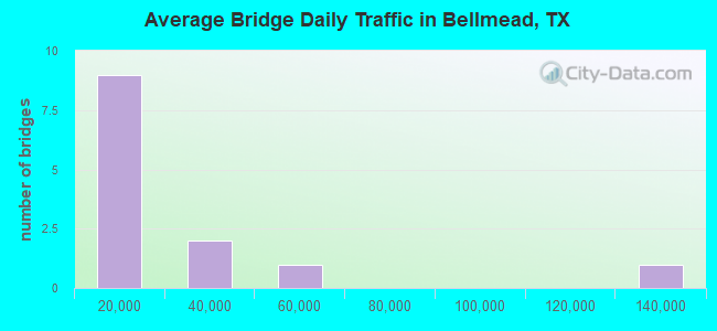
- 308,397Total average daily traffic
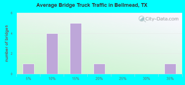
- 28,048Total average daily truck traffic
- National Bridge Inventory (NBI) Registered Bridges for Bellmead
- No street view available for this location
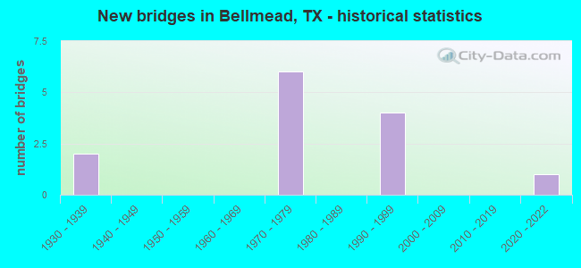
- New bridges - historical statistics
- 21930-1939
- 61970-1979
- 41990-1999
- 12020-2022
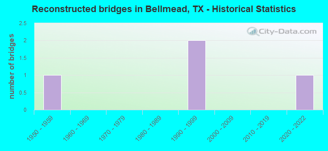
- Reconstructed bridges - Historical Statistics
- 11950-1959
- 01960-1969
- 01970-1979
- 01980-1989
- 21990-1999
- 02000-2009
- 02010-2019
- 12020-2022
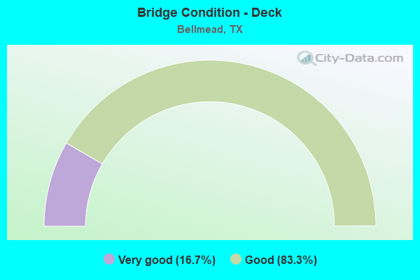
- Bridge Condition - Deck
- 16.7%Very good
- 83.3%Good
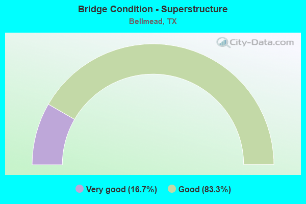
- Bridge Condition - Superstructure
- 16.7%Very good
- 83.3%Good
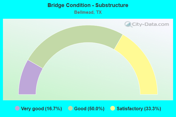
- Bridge Condition - Substructure
- 16.7%Very good
- 50.0%Good
- 33.3%Satisfactory
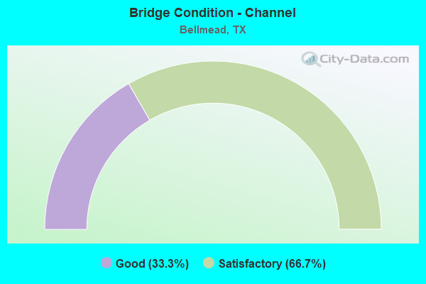
- Bridge Condition - Channel
- 33.3%Good
- 66.7%Satisfactory
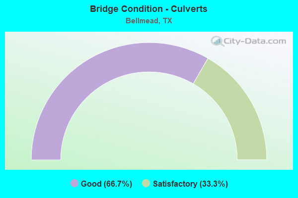
- Bridge Condition - Culverts
- 66.7%Good
- 33.3%Satisfactory
Find on map >> Show street view
Structure Number: 91610001501319, Location: 1.5 Mi NE of US 84 (Lat: 31.604622, Lng: -97.106092), Route carried "on" structure: Interstate 35, Year Built: 1972, Year Reconstructed: 2020, Status: Not yet open, Structure Length: 9.75m (31.99ft), Average Daily Traffic: 43,233 (year 2017), Truck Traffic: 31%, Average Future Daily Traffic: 56,195 (year 2037), Design Load: HS 20, Features Intersected: Loop 340
Minimum Vertical Clearance: 30+ m (98+ ft), Kilometerpoint: 30.906, Lanes on structure: 4, Lanes under structure: 6, Base Highway Network: Yes, Owner: State Highway Agency, Approaching Roadway Width: 16.5m (54.1ft), Material/Design: Prestressed concrete, Design/Construction: Stringer/Multi-beam, Number Of Spans In Main Unit: 4, Length of Maximum Span: 24.4m (80.1ft), Curb-To-Curb Width: 16.5m (54.1ft), Out-to-Out Width: 17.0m (55.8ft)
Condition: Deck: Good, Superstructure: Good, Substructure: Good, Operating Rating: 54.4 metric tons, Method Used To Determine Operating Rating: Assigned rating based on Load Factor Design (LFD) reported in metric tons, Inventory Rating: 32.7 metric tons, Method Used To Determine Inventory Rating: Assigned rating based on Load Factor Design (LFD) reported in metric tons, Structural Evaluation: Better than present minimum criteria, Deck Geometry: Meets minimum limits, Underclear: Equal to present minimum criteria, Approach Roadway Alignment: Equal to present desirable criteria, Length Of Structure Improvement: 12.19m (39.99ft), Designated Inspection Frequency: Every 24 months, Inspection Date: Febuary 2021, Bridge Improvement Cost: $1,200,000, Roadway Improvement Cost: $300,000, Total Project Cost: $1,800,000, Deck Structure Type: Concrete Cast-file-Place
Find on map >> Show street view
Structure Number: 91610001501746, Location: 0.75 MI N OF US 84 (Lat: 31.595600, Lng: -97.109258), Route carried "on" structure: Interstate 35, Year Built: 2021, Status: Open, Structure Length: 8.08m (26.51ft), Average Daily Traffic: 125,400 (year 2019), Average Future Daily Traffic: 1 (year 1900), Design Load: HL 93, Features Intersected: BEHRENS CIRCLE
Minimum Vertical Clearance: 30+ m (98+ ft), Kilometerpoint: 0.000, Lanes on structure: 5, Lanes under structure: 8, Base Highway Network: Yes, Owner: State Highway Agency, Approaching Roadway Width: 18.3m (60.0ft), Material/Design: Prestressed concrete, Design/Construction: Box Beam or Girders - Multiple, Number Of Spans In Main Unit: 3, Length of Maximum Span: 38.1m (125.0ft), Curb-To-Curb Width: 18.3m (60.0ft), Out-to-Out Width: 26.2m (86.0ft)
Condition: Deck: Very good, Superstructure: Very good, Substructure: Very good, Operating Rating: 54.4 metric tons, Method Used To Determine Operating Rating: Assigned ratings based on Load and Resistance Factor Design (LRFD) reported in metric tons, Inventory Rating: 32.7 metric tons, Method Used To Determine Inventory Rating: Assigned ratings based on Load and Resistance Factor Design (LRFD) reported in metric tons, Structural Evaluation: Equal to present desirable criteria, Deck Geometry: High priority of replacement, Underclear: High priority of corrective action, Approach Roadway Alignment: Equal to present desirable criteria, Designated Inspection Frequency: Every 24 months, Inspection Date: June 2021, Deck Structure Type: Concrete Cast-file-Place
Find on map >> Show street view
Structure Number: 91610016201001, Location: 0.40 Mi NE of IH 35 (Lat: 31.582100, Lng: -97.107761), Route carried "on" structure: State highway 299, Year Built: 1932, Year Reconstructed: 1955, Status: Open, Structure Length: 0.76m (2.49ft), Average Daily Traffic: 4,512 (year 2020), Truck Traffic: 12%, Average Future Daily Traffic: 9,340 (year 2033), Design Load: H 15, Features Intersected: Bellmead Ditch
Minimum Vertical Clearance: 30+ m (98+ ft), Kilometerpoint: 0.790, Lanes on structure: 5, Owner: State Highway Agency, Approaching Roadway Width: 19.5m (64.0ft), Material/Design: Concrete, Design/Construction: Culvert, Number Of Spans In Main Unit: 7, Length of Maximum Span: 0.9m (3.0ft), Curb-To-Curb Width: 20.4m (66.9ft), Out-to-Out Width: 21.3m (69.9ft)
Condition: Channel: Good, Culverts: Satisfactory, Operating Rating: 39.9 metric tons, Method Used To Determine Operating Rating: Load Factor (LF), Inventory Rating: 23.6 metric tons, Method Used To Determine Inventory Rating: Load Factor (LF), Structural Evaluation: Equal to present minimum criteria, Deck Geometry: Somewhat better than minimum adequacy, Waterway Adequacy: Equal to present minimum criteria, Approach Roadway Alignment: Equal to present desirable criteria, Length Of Structure Improvement: 1.83m (6.00ft), Designated Inspection Frequency: Every 24 months, Inspection Date: December 2020, Bridge Improvement Cost: $200,000, Roadway Improvement Cost: $100,000, Total Project Cost: $400,000, Deck Structure Type: Concrete Cast-file-Place, Wearing Surface/Protective System: Wearing Surface: Bituminous
Find on map >> Show street view
Structure Number: 91610016201004, Location: 1.3 Mi NE of LP 340 (Lat: 31.609411, Lng: -97.068772), Route carried "on" structure: US 84, Year Built: 1932, Year Reconstructed: 2002, Status: Open, Structure Length: 1.01m (3.31ft), Average Daily Traffic: 18,838 (year 2020), Truck Traffic: 9%, Average Future Daily Traffic: 28,640 (year 2037), Design Load: H 15, Features Intersected: Lucky Branch
Minimum Vertical Clearance: 30+ m (98+ ft), Kilometerpoint: 5.650, Lanes on structure: 4, Base Highway Network: Yes, Owner: State Highway Agency, Approaching Roadway Width: 24.4m (80.1ft), Material/Design: Concrete, Design/Construction: Culvert, Number Of Spans In Main Unit: 3, Length of Maximum Span: 3.0m (9.8ft)
Condition: Channel: Satisfactory, Culverts: Good, Operating Rating: 39.9 metric tons, Method Used To Determine Operating Rating: Load Factor (LF), Inventory Rating: 23.6 metric tons, Method Used To Determine Inventory Rating: Load Factor (LF), Structural Evaluation: Somewhat better than minimum adequacy, Waterway Adequacy: Equal to present minimum criteria, Approach Roadway Alignment: Equal to present desirable criteria, Length Of Structure Improvement: 1.83m (6.00ft), Designated Inspection Frequency: Every 24 months, Inspection Date: Febuary 2021, Bridge Improvement Cost: $200,000, Roadway Improvement Cost: $100,000, Total Project Cost: $400,000
Find on map >> Show street view
Structure Number: 91610016201078, Location: 0.3 Mi SW of LP 340 (Lat: 31.596631, Lng: -97.092431), Route carried "on" structure: US 84, Year Built: 1978, Status: Open, Structure Length: 9.14m (29.99ft), Average Daily Traffic: 14,107 (year 2020), Truck Traffic: 3%, Average Future Daily Traffic: 25,260 (year 2037), Design Load: HS 20, Features Intersected: UPRR
Minimum Vertical Clearance: 30+ m (98+ ft), Kilometerpoint: 2.861, Lanes on structure: 4, Base Highway Network: Yes, Owner: State Highway Agency, Approaching Roadway Width: 17.1m (56.1ft), Skew: 4 degrees, Material/Design: Prestressed concrete, Design/Construction: Stringer/Multi-beam, Number Of Spans In Main Unit: 5, Length of Maximum Span: 18.3m (60.0ft), Curb or Sidewalk Widths: Left: 0.7m (2.3ft), Right: 0.7m (2.3ft), Curb-To-Curb Width: 17.2m (56.4ft), Out-to-Out Width: 19.2m (63.0ft)
Condition: Deck: Good, Superstructure: Good, Substructure: Good, Operating Rating: 54.4 metric tons, Method Used To Determine Operating Rating: Assigned rating based on Load Factor Design (LFD) reported in metric tons, Inventory Rating: 32.7 metric tons, Method Used To Determine Inventory Rating: Assigned rating based on Load Factor Design (LFD) reported in metric tons, Structural Evaluation: Better than present minimum criteria, Deck Geometry: Somewhat better than minimum adequacy, Underclear: Somewhat better than minimum adequacy, Approach Roadway Alignment: Equal to present desirable criteria, Length Of Structure Improvement: 11.43m (37.50ft), Designated Inspection Frequency: Every 24 months, Inspection Date: January 2021, Bridge Improvement Cost: $1,100,000, Roadway Improvement Cost: $300,000, Total Project Cost: $1,700,000, Deck Structure Type: Concrete Cast-file-Place, Wearing Surface/Protective System: Wearing Surface: Bituminous
Find on map >> Show street view
Structure Number: 91610016201084, Location: 2.4 Mi SE of IH 35 (Lat: 31.598803, Lng: -97.089031), Route carried "on" structure: Bypass State highway 2418, Year Built: 1990, Status: Open, Structure Length: 9.30m (30.51ft), Average Daily Traffic: 13,912 (year 2017), Truck Traffic: 10%, Average Future Daily Traffic: 19,480 (year 2037), Design Load: HS 20, Features Intersected: US 84, Facility Carried by Structure: Loop 340
Minimum Vertical Clearance: 30+ m (98+ ft), Kilometerpoint: 4.157, Lanes on structure: 5, Lanes under structure: 4, Base Highway Network: Yes, Owner: State Highway Agency, Approaching Roadway Width: 25.6m (84.0ft), Skew: 1 degrees, Material/Design: Prestressed concrete continuous, Design/Construction: Stringer/Multi-beam, Number Of Spans In Main Unit: 1, Number Of Approach Spans: 2, Length of Maximum Span: 38.1m (125.0ft), Curb or Sidewalk Widths: Left: 0.0m, Right: 1.2m (3.9ft), Curb-To-Curb Width: 25.5m (83.7ft), Out-to-Out Width: 27.6m (90.6ft)
Condition: Deck: Good, Superstructure: Good, Substructure: Good, Operating Rating: 54.4 metric tons, Method Used To Determine Operating Rating: Assigned rating based on Load Factor Design (LFD) reported in metric tons, Inventory Rating: 32.7 metric tons, Method Used To Determine Inventory Rating: Assigned rating based on Load Factor Design (LFD) reported in metric tons, Structural Evaluation: Better than present minimum criteria, Deck Geometry: Superior to present desirable criteria, Underclear: Better than present minimum criteria, Approach Roadway Alignment: Equal to present desirable criteria, Length Of Structure Improvement: 11.61m (38.09ft), Designated Inspection Frequency: Every 24 months, Inspection Date: January 2021, Bridge Improvement Cost: $1,200,000, Roadway Improvement Cost: $300,000, Total Project Cost: $1,800,000, Deck Structure Type: Concrete Cast-file-Place, Wearing Surface/Protective System: Wearing Surface: Bituminous
Find on map >> Show street view
Structure Number: 91610231101004, Location: 0.3 Mi W of FM 2418 (Lat: 31.601858, Lng: -97.093350), Route carried "on" structure: State highway 340, Year Built: 1978, Status: Open, Structure Length: 0.94m (3.08ft), Average Daily Traffic: 20,557 (year 2020), Truck Traffic: 17%, Average Future Daily Traffic: 27,200 (year 2033), Design Load: HS 20, Features Intersected: Trib of Brazos River
Minimum Vertical Clearance: 30+ m (98+ ft), Kilometerpoint: 12.595, Lanes on structure: 6, Owner: State Highway Agency, Approaching Roadway Width: 28.3m (92.8ft), Skew: 3 degrees, Material/Design: Concrete, Design/Construction: Culvert, Number Of Spans In Main Unit: 4, Length of Maximum Span: 1.8m (5.9ft)
Condition: Channel: Satisfactory, Culverts: Good, Operating Rating: 39.9 metric tons, Method Used To Determine Operating Rating: Load Factor (LF), Inventory Rating: 23.6 metric tons, Method Used To Determine Inventory Rating: Load Factor (LF), Structural Evaluation: Somewhat better than minimum adequacy, Waterway Adequacy: Equal to present minimum criteria, Approach Roadway Alignment: Equal to present desirable criteria, Designated Inspection Frequency: Every 48 months, Inspection Date: January 2021
Find on map >> Show street view
Structure Number: 91610231101005, Location: 0.2 Mi W of US 84 (Lat: 31.601319, Lng: -97.092869), Route carried "on" structure: State highway 340, Year Built: 1978, Year Reconstructed: 1990, Status: Open, Structure Length: 6.40m (21.00ft), Average Daily Traffic: 13,890 (year 2019), Truck Traffic: 9%, Average Future Daily Traffic: 29,260 (year 2037), Design Load: HS 20, Features Intersected: UP RR & FM 2418 SB
Minimum Vertical Clearance: 30+ m (98+ ft), Kilometerpoint: 12.592, Lanes on structure: 3, Lanes under structure: 2, Base Highway Network: Yes, Owner: State Highway Agency, Approaching Roadway Width: 15.2m (49.9ft), Skew: 3 degrees, Material/Design: Concrete continuous, Design/Construction: Slab, Number Of Spans In Main Unit: 4, Length of Maximum Span: 18.3m (60.0ft), Curb-To-Curb Width: 15.2m (49.9ft), Out-to-Out Width: 15.6m (51.2ft)
Condition: Deck: Good, Superstructure: Good, Substructure: Satisfactory, Operating Rating: 47.2 metric tons, Method Used To Determine Operating Rating: Load Factor (LF), Inventory Rating: 28.1 metric tons, Method Used To Determine Inventory Rating: Load Factor (LF), Structural Evaluation: Equal to present minimum criteria, Deck Geometry: Equal to present minimum criteria, Underclear: Meets minimum limits, Approach Roadway Alignment: Equal to present desirable criteria, Designated Inspection Frequency: Every 24 months, Inspection Date: January 2021, Deck Structure Type: Concrete Cast-file-Place, Wearing Surface/Protective System: Wearing Surface: Bituminous
Find on map >> Show street view
Structure Number: 91610231101006, Location: 0.2 Mi W of US 84 (Lat: 31.601294, Lng: -97.093394), Route carried "on" structure: State highway 340, Year Built: 1990, Status: Open, Structure Length: 6.40m (21.00ft), Average Daily Traffic: 10,689 (year 2020), Truck Traffic: 9%, Average Future Daily Traffic: 29,260 (year 2037), Design Load: HS 20, Features Intersected: UP RR & FM 2418 SB
Minimum Vertical Clearance: 30+ m (98+ ft), Kilometerpoint: 12.592, Lanes on structure: 3, Lanes under structure: 2, Base Highway Network: Yes, Owner: State Highway Agency, Approaching Roadway Width: 15.2m (49.9ft), Skew: 3 degrees, Material/Design: Concrete, Design/Construction: Slab, Number Of Spans In Main Unit: 4, Length of Maximum Span: 18.3m (60.0ft), Curb or Sidewalk Widths: Left: 0.0m, Right: 1.5m (4.9ft), Curb-To-Curb Width: 15.2m (49.9ft), Out-to-Out Width: 18.3m (60.0ft)
Condition: Deck: Good, Superstructure: Good, Substructure: Satisfactory, Operating Rating: 47.2 metric tons, Method Used To Determine Operating Rating: Load Factor (LF), Inventory Rating: 28.1 metric tons, Method Used To Determine Inventory Rating: Load Factor (LF), Structural Evaluation: Equal to present minimum criteria, Deck Geometry: Equal to present minimum criteria, Underclear: Meets minimum limits, Approach Roadway Alignment: Equal to present desirable criteria, Length Of Structure Improvement: 6.40m (21.00ft), Designated Inspection Frequency: Every 24 months, Inspection Date: January 2021, Bridge Improvement Cost: $571,000, Roadway Improvement Cost: $143,000, Total Project Cost: $714,000, Deck Structure Type: Concrete Cast-file-Place, Wearing Surface/Protective System: Wearing Surface: Bituminous
Find on map >> Show street view
Structure Number: 91610001501319, Location: 1.5 Mi NE of US 84 (Lat: 31.604622, Lng: -97.106092), Route carried "under" structure: State highway 340, Year Built: 1972, Structure Length: 0. m, Average Daily Traffic: 20,899 (year 2017), Truck Traffic: 9%, Features Intersected: Loop 340, Facility Carried by Structure: IH 35 NB
Minimum Vertical Clearance: 5.72m (18.77ft), Kilometerpoint: 11.393, Lanes on structure: 3, Lanes under structure: 6, Material/Design: Prestressed concrete, Design/Construction: Stringer/Multi-beam, Length of Maximum Span: 24.4m (80.1ft)
Find on map >> Show street view
Structure Number: 91610016201084, Location: 2.4 Mi SE of IH 35 (Lat: 31.598803, Lng: -97.089031), Route carried "under" structure: US 84, Year Built: 1990, Structure Length: 0. m, Average Daily Traffic: 19,360 (year 2013), Truck Traffic: 14%, Features Intersected: US 84, Facility Carried by Structure: Loop 340
Minimum Vertical Clearance: 5.69m (18.67ft), Kilometerpoint: 3.523, Lanes on structure: 5, Lanes under structure: 4, Material/Design: Prestressed concrete continuous, Design/Construction: Stringer/Multi-beam, Length of Maximum Span: 38.1m (125.0ft)
Find on map >> Show street view
Structure Number: 91610231101005, Location: 0.2 Mi W of US 84 (Lat: 31.601319, Lng: -97.092869), Route carried "under" structure: State highway 2418, Year Built: 1978, Structure Length: 0. m, Average Daily Traffic: 1,500 (year 2017), Truck Traffic: 10%, Features Intersected: UP RR & FM 2418 SB, Facility Carried by Structure: Loop 340 WB
Minimum Vertical Clearance: 7.57m (24.84ft), Kilometerpoint: 3.219, Lanes on structure: 3, Lanes under structure: 2, Material/Design: Concrete continuous, Design/Construction: Slab, Length of Maximum Span: 18.3m (60.0ft)
Find on map >> Show street view
Structure Number: 91610231101006, Location: 0.2 Mi W of US 84 (Lat: 31.601294, Lng: -97.093394), Route carried "under" structure: State highway 2418, Year Built: 1990, Structure Length: 0. m, Average Daily Traffic: 1,500 (year 2017), Truck Traffic: 10%, Features Intersected: UP RR & FM 2418 SB, Facility Carried by Structure: Loop 340 EB
Minimum Vertical Clearance: 7.26m (23.82ft), Kilometerpoint: 3.219, Lanes on structure: 4, Lanes under structure: 2, Material/Design: Concrete, Design/Construction: Slab, Length of Maximum Span: 18.3m (60.0ft)