Bridge Statistics for Berlin, Pennsylvania (PA)
Condition, Traffic, Stress, Structural Evaluation, Project Costs
- National Bridge Inventory (NBI) Statistics
- 12Number of bridges
- 59ft / 18.1mTotal length
- $3,067,000Total costs
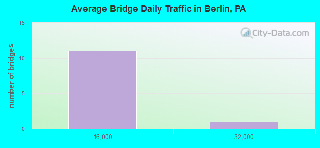
- 42,979Total average daily traffic
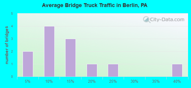
- 12,037Total average daily truck traffic
- National Bridge Inventory (NBI) Registered Bridges for Berlin
- No street view available for this location
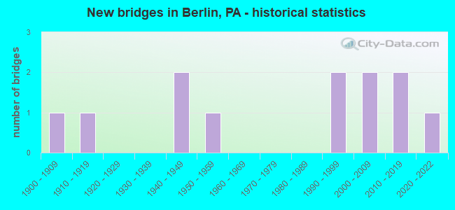
- New bridges - historical statistics
- 11900-1909
- 11910-1919
- 21940-1949
- 11950-1959
- 21990-1999
- 22000-2009
- 22010-2019
- 12020-2022
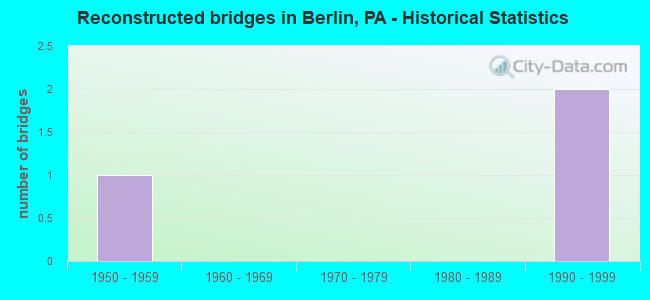
- Reconstructed bridges - Historical Statistics
- 11950-1959
- 01960-1969
- 01970-1979
- 01980-1989
- 21990-1999
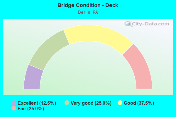
- Bridge Condition - Deck
- 12.5%Excellent
- 25.0%Very good
- 37.5%Good
- 25.0%Fair
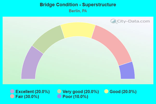
- Bridge Condition - Superstructure
- 20.0%Excellent
- 20.0%Very good
- 20.0%Good
- 30.0%Fair
- 10.0%Poor
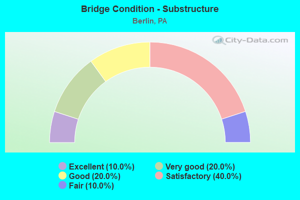
- Bridge Condition - Substructure
- 10.0%Excellent
- 20.0%Very good
- 20.0%Good
- 40.0%Satisfactory
- 10.0%Fair
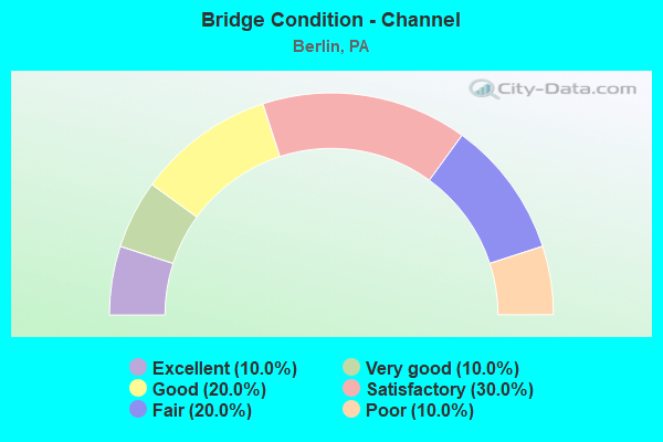
- Bridge Condition - Channel
- 10.0%Excellent
- 10.0%Very good
- 20.0%Good
- 30.0%Satisfactory
- 20.0%Fair
- 10.0%Poor
Find on map >> Show street view
Structure Number: 31344, Location: .6 MI.W.OF ROXBURY (Lat: 39.954092, Lng: -78.920142), Route carried "on" structure: State highway 31, Year Built: 1941, Year Reconstructed: 1956, Status: Open, Structure Length: 1.22m (4.00ft), Average Daily Traffic: 2,006 (year 2020), Truck Traffic: 15%, Average Future Daily Traffic: 3,266 (year 2032), Design Load: H 20, Features Intersected: TR.STONY CREEK
Minimum Vertical Clearance: 30+ m (98+ ft), Kilometerpoint: 34.335, Lanes on structure: 2, Base Highway Network: Yes, Owner: State Highway Agency, Approaching Roadway Width: 8.8m (28.9ft), Material/Design: Concrete, Design/Construction: Tee Beam, Number Of Spans In Main Unit: 1, Length of Maximum Span: 10.4m (34.1ft), Curb or Sidewalk Widths: Left: 0.2m (0.7ft), Right: 0.2m (0.7ft), Curb-To-Curb Width: 11.0m (36.1ft), Out-to-Out Width: 12.2m (40.0ft)
Condition: Deck: Fair, Superstructure: Fair, Substructure: Fair, Channel: Poor, Operating Rating: 50.8 metric tons, Method Used To Determine Operating Rating: Load Factor (LF), Inventory Rating: 29.9 metric tons, Method Used To Determine Inventory Rating: Load Factor (LF), Structural Evaluation: Somewhat better than minimum adequacy, Deck Geometry: Somewhat better than minimum adequacy, Waterway Adequacy: Equal to present minimum criteria, Approach Roadway Alignment: Equal to present desirable criteria, Length Of Structure Improvement: 1.50m (4.92ft), Designated Inspection Frequency: Every 24 months, Inspection Date: December 2020, Bridge Improvement Cost: $52,000, Roadway Improvement Cost: $264,000, Total Project Cost: $707,000, Deck Structure Type: Concrete Cast-file-Place, Wearing Surface/Protective System: Wearing Surface: Bituminous
Find on map >> Show street view
Structure Number: 31359, Location: 1.5 MI.S.OF BERLIN (Lat: 39.898419, Lng: -78.954000), Route carried "on" structure: State highway 160, Year Built: 1900, Year Reconstructed: 2001, Status: Open, Structure Length: 0.91m (2.99ft), Average Daily Traffic: 1,968 (year 2020), Truck Traffic: 6%, Average Future Daily Traffic: 3,014 (year 2032), Features Intersected: BUFFALO CREEK
Minimum Vertical Clearance: 30+ m (98+ ft), Kilometerpoint: 26.479, Lanes on structure: 2, Owner: State Highway Agency, Approaching Roadway Width: 8.5m (27.9ft), Material/Design: Masonry, Design/Construction: Arch - Deck, Number Of Spans In Main Unit: 1, Length of Maximum Span: 9.1m (29.9ft), Curb-To-Curb Width: 7.9m (25.9ft), Out-to-Out Width: 9.5m (31.2ft)
Condition: Superstructure: Poor, Substructure: Satisfactory, Channel: Fair, Operating Rating: 55.3 metric tons, Method Used To Determine Operating Rating: Field evaluation and documented engineering judgment, Inventory Rating: 32.7 metric tons, Method Used To Determine Inventory Rating: Field evaluation and documented engineering judgment, Structural Evaluation: Meets minimum limits, Deck Geometry: Meets minimum limits, Waterway Adequacy: Equal to present desirable criteria, Approach Roadway Alignment: Equal to present desirable criteria, Length Of Structure Improvement: 9.10m (29.86ft), Designated Inspection Frequency: Every 24 months, Other Special Inspection Frequency: Every 12 months, Inspection Date: April 2020, Other Special Inspection Date: April 2021
Find on map >> Show street view
Structure Number: 31384, Location: 2 MI.S.OF BERLIN (Lat: 39.902900, Lng: -79.000725), Route carried "on" structure: State highway , Year Built: 1997, Status: Open, Structure Length: 1.89m (6.20ft), Average Daily Traffic: 1,031 (year 2020), Truck Traffic: 23%, Average Future Daily Traffic: 2,601 (year 2032), Design Load: HS 25 or greater, Features Intersected: BUFFALO CREEK, Facility Carried by Structure: SR 2047
Minimum Vertical Clearance: 30+ m (98+ ft), Kilometerpoint: 16.771, Lanes on structure: 2, Owner: State Highway Agency, Approaching Roadway Width: 12.5m (41.0ft), Skew: 1 degrees, Material/Design: Prestressed concrete, Design/Construction: Box Beam or Girders - Single/Spread, Number Of Spans In Main Unit: 1, Length of Maximum Span: 18.3m (60.0ft), Curb or Sidewalk Widths: Left: 0.2m (0.7ft), Right: 0.2m (0.7ft), Curb-To-Curb Width: 12.2m (40.0ft), Out-to-Out Width: 13.3m (43.6ft)
Condition: Deck: Good, Superstructure: Good, Substructure: Good, Channel: Satisfactory, Operating Rating: 89.8 metric tons, Method Used To Determine Operating Rating: Load Factor (LF), Inventory Rating: 50.8 metric tons, Method Used To Determine Inventory Rating: Load Factor (LF), Structural Evaluation: Better than present minimum criteria, Deck Geometry: Better than present minimum criteria, Waterway Adequacy: Equal to present desirable criteria, Approach Roadway Alignment: Equal to present desirable criteria, Length Of Structure Improvement: 2.50m (8.20ft), Designated Inspection Frequency: Every 48 months, Inspection Date: December 2018, Deck Structure Type: Concrete Cast-file-Place, Wearing Surface/Protective System: Wearing Surface: Monolithic Concrete, Deck Protection: Epoxy Coated Reinforcing
Find on map >> Show street view
Structure Number: 31386, Location: 1.5 MI.N.OF BERLIN (Lat: 39.938867, Lng: -78.983008), Route carried "on" structure: State highway , Year Built: 1951, Year Reconstructed: 2021, Status: Open, Structure Length: 1.04m (3.41ft), Average Daily Traffic: 4,051 (year 2020), Truck Traffic: 5%, Average Future Daily Traffic: 5,977 (year 2032), Design Load: HS 20, Features Intersected: TRIB MILLER RUN, Facility Carried by Structure: SR 2047
Minimum Vertical Clearance: 30+ m (98+ ft), Kilometerpoint: 23.511, Lanes on structure: 2, Owner: State Highway Agency, Approaching Roadway Width: 9.1m (29.9ft), Skew: 3 degrees, Material/Design: Concrete, Design/Construction: Tee Beam, Number Of Spans In Main Unit: 1, Length of Maximum Span: 9.8m (32.2ft), Curb or Sidewalk Widths: Left: 0.2m (0.7ft), Right: 0.2m (0.7ft), Curb-To-Curb Width: 12.2m (40.0ft), Out-to-Out Width: 13.3m (43.6ft)
Condition: Deck: Fair, Superstructure: Fair, Substructure: Satisfactory, Channel: Fair, Operating Rating: 59.0 metric tons, Method Used To Determine Operating Rating: Load Factor (LF), Inventory Rating: 35.4 metric tons, Method Used To Determine Inventory Rating: Load Factor (LF), Structural Evaluation: Somewhat better than minimum adequacy, Deck Geometry: Equal to present minimum criteria, Waterway Adequacy: Equal to present minimum criteria, Approach Roadway Alignment: Equal to present desirable criteria, Length Of Structure Improvement: 1.30m (4.27ft), Designated Inspection Frequency: Every 24 months, Inspection Date: September 2020, Bridge Improvement Cost: $49,000, Roadway Improvement Cost: $264,000, Total Project Cost: $660,000, Deck Structure Type: Concrete Cast-file-Place, Wearing Surface/Protective System: Wearing Surface: Monolithic Concrete, Deck Protection: Epoxy Coated Reinforcing
Find on map >> Show street view
Structure Number: 31652, Location: 1.5 MI.SW.OF BERLIN (Lat: 39.900442, Lng: -78.978200), Route carried "on" structure: State highway , Year Built: 1941, Year Reconstructed: 2001, Status: Open, Structure Length: 1.34m (4.40ft), Average Daily Traffic: 233 (year 2022), Truck Traffic: 9%, Average Future Daily Traffic: 549 (year 2032), Design Load: H 20, Features Intersected: BUFFALO CREEK, Facility Carried by Structure: SR 2027
Minimum Vertical Clearance: 30+ m (98+ ft), Kilometerpoint: 10.890, Lanes on structure: 2, Owner: State Highway Agency, Approaching Roadway Width: 6.1m (20.0ft), Skew: 1 degrees, Material/Design: Steel, Design/Construction: Stringer/Multi-beam, Number Of Spans In Main Unit: 1, Length of Maximum Span: 12.8m (42.0ft), Curb-To-Curb Width: 7.3m (24.0ft), Out-to-Out Width: 7.8m (25.6ft)
Condition: Deck: Good, Superstructure: Very good, Substructure: Satisfactory, Channel: Satisfactory, Operating Rating: 89.8 metric tons, Method Used To Determine Operating Rating: Load Factor (LF), Inventory Rating: 64.4 metric tons, Method Used To Determine Inventory Rating: Load Factor (LF), Structural Evaluation: Equal to present minimum criteria, Deck Geometry: Somewhat better than minimum adequacy, Waterway Adequacy: Better than present minimum criteria, Approach Roadway Alignment: Equal to present desirable criteria, Length Of Structure Improvement: 1.70m (5.58ft), Designated Inspection Frequency: Every 24 months, Inspection Date: October 2020, Bridge Improvement Cost: $55,000, Roadway Improvement Cost: $264,000, Total Project Cost: $743,000, Deck Structure Type: Concrete Cast-file-Place, Wearing Surface/Protective System: Wearing Surface: Monolithic Concrete, Deck Protection: Galvanized Reinforcing
Find on map >> Show street view
Structure Number: 31815, Location: NEAR BROTHERTON (Lat: 39.975000, Lng: -78.941667), Route carried "on" structure: City street , Year Built: 2002, Status: Open, Structure Length: 4.75m (15.58ft), Average Daily Traffic: 200 (year 1992), Truck Traffic: 8%, Average Future Daily Traffic: 315 (year 2030), Design Load: HL 93, Features Intersected: PA TPK (I-76), Facility Carried by Structure: T-513 Horse Track
Minimum Vertical Clearance: 30+ m (98+ ft), Kilometerpoint: 0.000, Lanes on structure: 2, Lanes under structure: 4, Owner: State Toll Authority, Approaching Roadway Width: 8.2m (26.9ft), Skew: 1 degrees, Material/Design: Steel, Design/Construction: Stringer/Multi-beam, Number Of Spans In Main Unit: 1, Length of Maximum Span: 46.9m (153.9ft), Curb-To-Curb Width: 8.4m (27.6ft), Out-to-Out Width: 9.3m (30.5ft)
Condition: Deck: Good, Superstructure: Good, Substructure: Good, Inventory Rating: 66.2 metric tons, Method Used To Determine Inventory Rating: Load Factor (LF), Structural Evaluation: Better than present minimum criteria, Deck Geometry: Somewhat better than minimum adequacy, Underclear: Somewhat better than minimum adequacy, Approach Roadway Alignment: Equal to present minimum criteria, Length Of Structure Improvement: 3.40m (11.15ft), Designated Inspection Frequency: Every 48 months, Inspection Date: April 2019, Bridge Improvement Cost: $17,000, Roadway Improvement Cost: $50,000, Total Project Cost: $228,000, Deck Structure Type: Concrete Cast-file-Place, Wearing Surface/Protective System: Wearing Surface: Monolithic Concrete, Deck Protection: Epoxy Coated Reinforcing
Find on map >> Show street view
Structure Number: 3184, Location: 2 MI.SW.OF BERLIN (Lat: 39.909211, Lng: -78.997467), Route carried "on" structure: City street , Year Built: 1916, Status: Open, Structure Length: 1.28m (4.20ft), Average Daily Traffic: 50 (year 2021), Truck Traffic: 1%, Average Future Daily Traffic: 63 (year 2041), Features Intersected: MILLER RUN, Facility Carried by Structure: T618, OLDMILL ROAD
Minimum Vertical Clearance: 30+ m (98+ ft), Kilometerpoint: 0.000, Lanes on structure: 1, Owner: County Highway Agency, Approaching Roadway Width: 4.0m (13.1ft), Material/Design: Concrete, Design/Construction: Arch - Deck, Number Of Spans In Main Unit: 1, Length of Maximum Span: 12.8m (42.0ft), Curb or Sidewalk Widths: Left: 0.2m (0.7ft), Right: 0.2m (0.7ft), Curb-To-Curb Width: 4.6m (15.1ft), Out-to-Out Width: 5.3m (17.4ft)
Condition: Superstructure: Fair, Substructure: Satisfactory, Channel: Good, Operating Rating: 68.0 metric tons, Method Used To Determine Operating Rating: Field evaluation and documented engineering judgment, Inventory Rating: 40.8 metric tons, Method Used To Determine Inventory Rating: Field evaluation and documented engineering judgment, Structural Evaluation: Somewhat better than minimum adequacy, Deck Geometry: Better than present minimum criteria, Waterway Adequacy: Equal to present desirable criteria, Approach Roadway Alignment: Equal to present desirable criteria, Length Of Structure Improvement: 1.60m (5.25ft), Designated Inspection Frequency: Every 24 months, Inspection Date: June 2021, Bridge Improvement Cost: $54,000, Roadway Improvement Cost: $264,000, Total Project Cost: $729,000
Find on map >> Show street view
Structure Number: 47982, Location: 2.5Mi SW of Berlin (Lat: 39.897661, Lng: -78.992347), Route carried "on" structure: City street , Year Built: 1990, Status: Open, Structure Length: 0.73m (2.40ft), Average Daily Traffic: 50 (year 2021), Truck Traffic: 2%, Average Future Daily Traffic: 63 (year 2041), Design Load: HS 20, Features Intersected: Buffalo Creek, Facility Carried by Structure: T616,Buffalo Crk R
Minimum Vertical Clearance: 30+ m (98+ ft), Kilometerpoint: 0.000, Lanes on structure: 2, Owner: County Highway Agency, Approaching Roadway Width: 3.7m (12.1ft), Material/Design: Steel, Design/Construction: Culvert, Number Of Spans In Main Unit: 1, Length of Maximum Span: 7.3m (24.0ft)
Condition: Channel: Satisfactory, Culverts: Satisfactory, Operating Rating: 49.0 metric tons, Method Used To Determine Operating Rating: Field evaluation and documented engineering judgment, Inventory Rating: 32.7 metric tons, Method Used To Determine Inventory Rating: Field evaluation and documented engineering judgment, Structural Evaluation: Equal to present minimum criteria, Waterway Adequacy: Better than present minimum criteria, Approach Roadway Alignment: Equal to present desirable criteria, Designated Inspection Frequency: Every 24 months, Inspection Date: June 2021
Find on map >> Show street view
Structure Number: 48753, Location: SALCO (Lat: 39.901122, Lng: -78.940817), Route carried "on" structure: State highway , Year Built: 2014, Status: Open, Structure Length: 1.13m (3.71ft), Average Daily Traffic: 160 (year 2020), Truck Traffic: 11%, Average Future Daily Traffic: 228 (year 2034), Design Load: HL 93, Features Intersected: BUFFALO CREEK, Facility Carried by Structure: SR 2023
Minimum Vertical Clearance: 30+ m (98+ ft), Kilometerpoint: 4.165, Lanes on structure: 2, Owner: State Highway Agency, Approaching Roadway Width: 6.1m (20.0ft), Material/Design: Prestressed concrete, Design/Construction: Slab, Number Of Spans In Main Unit: 1, Length of Maximum Span: 11.0m (36.1ft), Curb-To-Curb Width: 7.5m (24.6ft), Out-to-Out Width: 8.6m (28.2ft)
Condition: Deck: Very good, Superstructure: Very good, Substructure: Very good, Channel: Very good, Operating Rating: 56.7 metric tons, Method Used To Determine Operating Rating: Assigned ratings based on Load and Resistance Factor Design (LRFD) reported by rating factor (RF) using HL93 loadings, Inventory Rating: 38.9 metric tons, Method Used To Determine Inventory Rating: Assigned ratings based on Load and Resistance Factor Design (LRFD) reported by rating factor (RF) using HL93 loadings, Structural Evaluation: Equal to present desirable criteria, Deck Geometry: Somewhat better than minimum adequacy, Waterway Adequacy: Better than present minimum criteria, Approach Roadway Alignment: Equal to present desirable criteria, Length Of Structure Improvement: 1.13m (3.71ft), Designated Inspection Frequency: Every 48 months, Inspection Date: Febuary 2020, Wearing Surface/Protective System: Wearing Surface: Bituminous, Membrane: Preformed Fabric, Deck Protection: Epoxy Coated Reinforcing
Find on map >> Show street view
Structure Number: 53981, Location: 0.5 MI EAST OF SR 1005 (Lat: 39.964969, Lng: -78.947725), Route carried "on" structure: State highway 31, Year Built: 2017, Status: Open, Structure Length: 2.23m (7.32ft), Average Daily Traffic: 3,352 (year 2020), Truck Traffic: 14%, Average Future Daily Traffic: 3,321 (year 2032), Design Load: HL 93, Features Intersected: SANDY HOLLOW CREEK
Minimum Vertical Clearance: 30+ m (98+ ft), Kilometerpoint: 31.672, Lanes on structure: 2, Base Highway Network: Yes, Owner: State Highway Agency, Maintenance Responsibility: Private, Approaching Roadway Width: 9.4m (30.8ft), Skew: 1 degrees, Material/Design: Prestressed concrete, Design/Construction: Box Beam or Girders - Single/Spread, Number Of Spans In Main Unit: 1, Length of Maximum Span: 21.0m (68.9ft), Curb-To-Curb Width: 12.4m (40.7ft), Out-to-Out Width: 13.0m (42.7ft)
Condition: Deck: Very good, Superstructure: Excellent, Substructure: Very good, Channel: Good, Operating Rating: 52.2 metric tons, Method Used To Determine Operating Rating: Assigned ratings based on Load and Resistance Factor Design (LRFD) reported by rating factor (RF) using HL93 loadings, Inventory Rating: 40.2 metric tons, Method Used To Determine Inventory Rating: Assigned ratings based on Load and Resistance Factor Design (LRFD) reported by rating factor (RF) using HL93 loadings, Structural Evaluation: Equal to present desirable criteria, Deck Geometry: Equal to present minimum criteria, Waterway Adequacy: Superior to present desirable criteria, Approach Roadway Alignment: Equal to present desirable criteria, Designated Inspection Frequency: Every 24 months, Inspection Date: July 2021, Deck Structure Type: Concrete Cast-file-Place, Wearing Surface/Protective System: Wearing Surface: Integral Concrete, Deck Protection: Epoxy Coated Reinforcing
Find on map >> Show street view
Structure Number: 67796, Location: .2 MI.NW.OF BERLIN (Lat: 39.929764, Lng: -78.975228), Route carried "on" structure: State highway , Year Built: 2020, Status: Open, Structure Length: 1.62m (5.31ft), Average Daily Traffic: 426 (year 2022), Truck Traffic: 13%, Average Future Daily Traffic: 450 (year 2030), Design Load: HL 93, Features Intersected: MILLERS RUN, Facility Carried by Structure: SR 3010
Minimum Vertical Clearance: 30+ m (98+ ft), Kilometerpoint: 23.773, Lanes on structure: 2, Owner: State Highway Agency, Approaching Roadway Width: 9.8m (32.2ft), Skew: 2 degrees, Material/Design: Prestressed concrete, Design/Construction: Box Beam or Girders - Single/Spread, Number Of Spans In Main Unit: 1, Length of Maximum Span: 15.2m (49.9ft), Curb-To-Curb Width: 9.8m (32.2ft), Out-to-Out Width: 10.8m (35.4ft)
Condition: Deck: Excellent, Superstructure: Excellent, Substructure: Excellent, Channel: Excellent, Operating Rating: 52.5 metric tons, Method Used To Determine Operating Rating: Assigned ratings based on Load and Resistance Factor Design (LRFD) reported by rating factor (RF) using HL93 loadings, Inventory Rating: 36.0 metric tons, Method Used To Determine Inventory Rating: Assigned ratings based on Load and Resistance Factor Design (LRFD) reported by rating factor (RF) using HL93 loadings, Structural Evaluation: Superior to present desirable criteria, Deck Geometry: Equal to present minimum criteria, Waterway Adequacy: Better than present minimum criteria, Approach Roadway Alignment: Equal to present desirable criteria, Length Of Structure Improvement: 1.60m (5.25ft), Designated Inspection Frequency: Every 24 months, Inspection Date: November 2020, Deck Structure Type: Concrete Cast-file-Place, Wearing Surface/Protective System: Wearing Surface: Monolithic Concrete, Deck Protection: Epoxy Coated Reinforcing
Find on map >> Show street view
Structure Number: 31815, Location: NEAR BROTHERTON (Lat: 39.975000, Lng: -78.941667), Route carried "under" structure: Other road 76, Year Built: 2002, Structure Length: 0. m, Average Daily Traffic: 29,452 (year 1999), Truck Traffic: 36%, Features Intersected: PA TPK (I-76), Facility Carried by Structure: T-513 Horse Track
Minimum Vertical Clearance: 5.33m (17.49ft), Kilometerpoint: 0.000, Lanes on structure: 2, Lanes under structure: 4, Material/Design: Steel, Design/Construction: Stringer/Multi-beam, Length of Maximum Span: 46.9m (153.9ft)