Bridge Statistics for Birch Run, Michigan (MI)
Condition, Traffic, Stress, Structural Evaluation, Project Costs
- National Bridge Inventory (NBI) Statistics
- 26Number of bridges
- 213ft / 64.8mTotal length
- $351,000Total costs
- 351,482Total average daily traffic
- 37,801Total average daily truck traffic
- National Bridge Inventory (NBI) Registered Bridges for Birch Run
- No street view available for this location
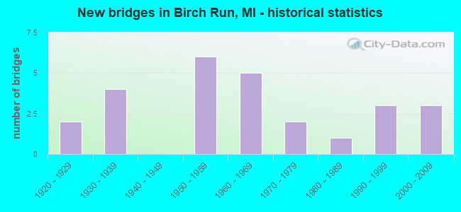
- New bridges - historical statistics
- 21920-1929
- 41930-1939
- 61950-1959
- 51960-1969
- 21970-1979
- 11980-1989
- 31990-1999
- 32000-2009
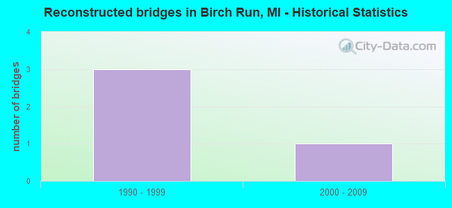
- Reconstructed bridges - Historical Statistics
- 31990-1999
- 12000-2009
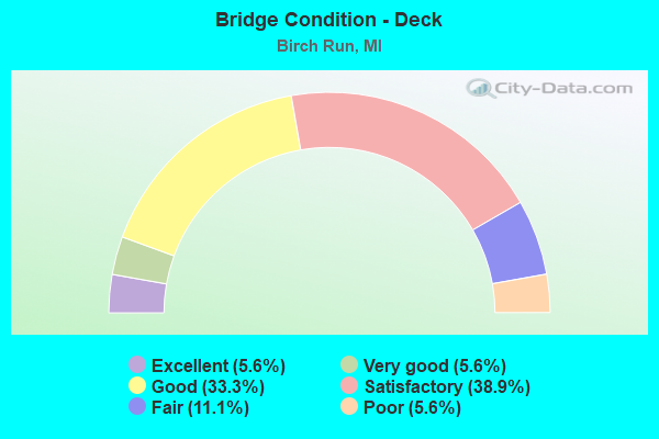
- Bridge Condition - Deck
- 5.6%Excellent
- 5.6%Very good
- 33.3%Good
- 38.9%Satisfactory
- 11.1%Fair
- 5.6%Poor
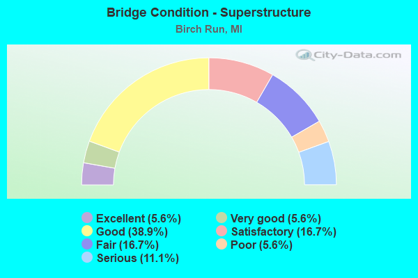
- Bridge Condition - Superstructure
- 5.6%Excellent
- 5.6%Very good
- 38.9%Good
- 16.7%Satisfactory
- 16.7%Fair
- 5.6%Poor
- 11.1%Serious
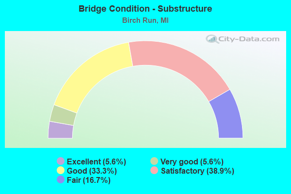
- Bridge Condition - Substructure
- 5.6%Excellent
- 5.6%Very good
- 33.3%Good
- 38.9%Satisfactory
- 16.7%Fair
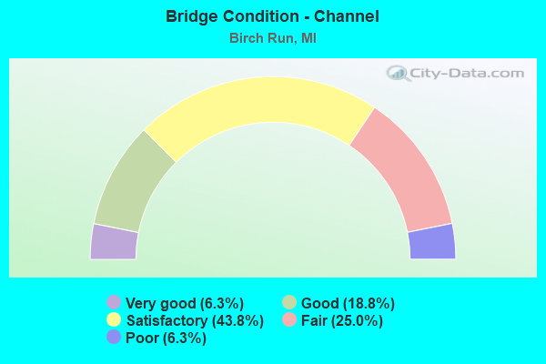
- Bridge Condition - Channel
- 6.3%Very good
- 18.8%Good
- 43.8%Satisfactory
- 25.0%Fair
- 6.3%Poor
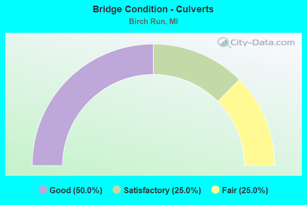
- Bridge Condition - Culverts
- 50.0%Good
- 25.0%Satisfactory
- 25.0%Fair
Find on map >> Show street view
Structure Number: 2739, Location: BET LAKE & WILLARD ROAD (Lat: 43.211719, Lng: -83.814389), Route carried "on" structure: County highway 2525, Year Built: 1929, Status: Open, Structure Length: 0.97m (3.18ft), Average Daily Traffic: 1,554 (year 2018), Truck Traffic: 5%, Average Future Daily Traffic: 2,809 (year 2038), Design Load: HS 20+Mod, Features Intersected: PINE RUN, Facility Carried by Structure: ELMS ROAD
Minimum Vertical Clearance: 30.48m (100.00ft), Kilometerpoint: 33.134, Lanes on structure: 2, Owner: County Highway Agency, Approaching Roadway Width: 9.1m (29.9ft), Skew: 2 degrees, Material/Design: Concrete, Design/Construction: Tee Beam, Number Of Spans In Main Unit: 1, Length of Maximum Span: 8.5m (27.9ft), Curb-To-Curb Width: 9.1m (29.9ft), Out-to-Out Width: 9.2m (30.2ft)
Condition: Deck: Excellent, Superstructure: Excellent, Substructure: Excellent, Channel: Satisfactory, Operating Rating: 97.2 metric tons, Method Used To Determine Operating Rating: Load and Resistance Factor Rating (LRFR) rating reported by rating factor(RF) method using HL-93 loadings, Inventory Rating: 66.1 metric tons, Method Used To Determine Inventory Rating: Load and Resistance Factor Rating (LRFR) rating reported by rating factor(RF) method using HL-93 loadings, Structural Evaluation: Superior to present desirable criteria, Deck Geometry: Somewhat better than minimum adequacy, Waterway Adequacy: Equal to present minimum criteria, Approach Roadway Alignment: Equal to present minimum criteria, Designated Inspection Frequency: Every 22 months, Inspection Date: December 2021, Deck Structure Type: Concrete Cast-file-Place, Wearing Surface/Protective System: Wearing Surface: Bituminous
Find on map >> Show street view
Structure Number: 2814, Location: 1000 FT WEST OF WEBSTER (Lat: 43.206364, Lng: -83.797658), Route carried "on" structure: County highway , Year Built: 1938, Status: Posted for load, Structure Length: 1.09m (3.58ft), Average Daily Traffic: 596 (year 2012), Truck Traffic: 2%, Average Future Daily Traffic: 1,076 (year 2032), Design Load: HS 20+Mod, Features Intersected: PINE RUN, Facility Carried by Structure: LAKE ROAD
Minimum Vertical Clearance: 30.48m (100.00ft), Kilometerpoint: 1.357, Lanes on structure: 2, Owner: County Highway Agency, Approaching Roadway Width: 9.9m (32.5ft), Material/Design: Steel, Design/Construction: Stringer/Multi-beam, Number Of Spans In Main Unit: 1, Length of Maximum Span: 10.3m (33.8ft), Curb-To-Curb Width: 9.1m (29.9ft), Out-to-Out Width: 10.2m (33.5ft)
Condition: Deck: Satisfactory, Superstructure: Serious, Substructure: Fair, Channel: Satisfactory, Operating Rating: 16.8 metric tons, Method Used To Determine Operating Rating: Load Factor (LF) rating reported by rating factor (RF) method using MS18 loading, Inventory Rating: 10.0 metric tons, Method Used To Determine Inventory Rating: Load Factor (LF) rating reported by rating factor (RF) method using MS18 loading, Structural Evaluation: High priority of corrective action, Deck Geometry: Equal to present minimum criteria, Waterway Adequacy: Better than present minimum criteria, Approach Roadway Alignment: Equal to present desirable criteria, Bridge Posting: Required (Relationship of Operating Rating to Maximum Legal Load: > 39.9% below), Designated Inspection Frequency: Every 12 months, Inspection Date: November 2021, Deck Structure Type: Concrete Cast-file-Place, Wearing Surface/Protective System: Wearing Surface: Monolithic Concrete
Find on map >> Show street view
Structure Number: 2816, Location: 1100 FT. SOUTH OF LAKE RD (Lat: 43.203075, Lng: -83.794072), Route carried "on" structure: County highway , Year Built: 1973, Status: Posted for load, Structure Length: 0.79m (2.59ft), Average Daily Traffic: 608 (year 2009), Truck Traffic: 2%, Average Future Daily Traffic: 1,098 (year 2029), Design Load: HS 20+Mod, Features Intersected: PINE RUN, Facility Carried by Structure: WEBSTER ROAD
Minimum Vertical Clearance: 30.48m (100.00ft), Kilometerpoint: 4.476, Lanes on structure: 2, Owner: County Highway Agency, Approaching Roadway Width: 11.0m (36.1ft), Material/Design: Wood or Timber, Design/Construction: Slab, Number Of Spans In Main Unit: 1, Length of Maximum Span: 7.3m (24.0ft), Curb-To-Curb Width: 10.1m (33.1ft), Out-to-Out Width: 10.8m (35.4ft)
Condition: Deck: Satisfactory, Superstructure: Satisfactory, Substructure: Satisfactory, Channel: Satisfactory, Operating Rating: 14.3 metric tons, Method Used To Determine Operating Rating: Allowable Stress (AS) rating reported by rating factor (RF) method using MS18 loading, Inventory Rating: 9.7 metric tons, Method Used To Determine Inventory Rating: Allowable Stress (AS) rating reported by rating factor (RF) method using MS18 loading, Structural Evaluation: High priority of corrective action, Deck Geometry: Equal to present minimum criteria, Waterway Adequacy: Equal to present desirable criteria, Approach Roadway Alignment: Equal to present desirable criteria, Bridge Posting: Required (Relationship of Operating Rating to Maximum Legal Load: > 39.9% below), Designated Inspection Frequency: Every 24 months, Inspection Date: November 2020, Deck Structure Type: Wood or Timber, Wearing Surface/Protective System: Wearing Surface: Bituminous
Find on map >> Show street view
Structure Number: 9183, Location: 4.1 MI NW OF GENESEE COL (Lat: 43.274425, Lng: -83.799908), Route carried "on" structure: Interstate 75, Year Built: 1961, Year Reconstructed: 1999, Status: Open, Structure Length: 1.37m (4.49ft), Average Daily Traffic: 25,771 (year 2007), Truck Traffic: 13%, Average Future Daily Traffic: 37,339 (year 2018), Design Load: HS 25 or greater, Features Intersected: BIRCH RUN CREEK
Minimum Vertical Clearance: 30.48m (100.00ft), Kilometerpoint: 6.692, Lanes on structure: 3, Base Highway Network: Yes (Inventory Route: 46, Subroute: 3), Owner: State Highway Agency, Approaching Roadway Width: 13.7m (44.9ft), Skew: 2 degrees, Material/Design: Steel, Design/Construction: Stringer/Multi-beam, Number Of Spans In Main Unit: 1, Length of Maximum Span: 13.7m (44.9ft), Curb-To-Curb Width: 18.6m (61.0ft), Out-to-Out Width: 22.6m (74.1ft)
Condition: Deck: Satisfactory, Superstructure: Very good, Substructure: Good, Channel: Poor, Operating Rating: 71.8 metric tons, Method Used To Determine Operating Rating: Load Factor (LF), Inventory Rating: 43.0 metric tons, Method Used To Determine Inventory Rating: Load Factor (LF), Structural Evaluation: Better than present minimum criteria, Deck Geometry: Superior to present desirable criteria, Waterway Adequacy: Equal to present desirable criteria, Approach Roadway Alignment: Equal to present desirable criteria, Designated Inspection Frequency: Every 24 months, Inspection Date: August 2021, Deck Structure Type: Concrete Cast-file-Place, Wearing Surface/Protective System: Wearing Surface: Monolithic Concrete, Deck Protection: Epoxy Coated Reinforcing
Find on map >> Show street view
Structure Number: 9189, Location: 0.5 MI N OF GENESEE COL (Lat: 43.226589, Lng: -83.768944), Route carried "on" structure: Interstate 75, Year Built: 1958, Year Reconstructed: 1998, Status: Open, Structure Length: 7.04m (23.10ft), Average Daily Traffic: 29,274 (year 2014), Truck Traffic: 7%, Average Future Daily Traffic: 33,665 (year 2034), Design Load: HS 20, Features Intersected: CSX RR
Minimum Vertical Clearance: 30.48m (100.00ft), Kilometerpoint: 0.587, Lanes on structure: 4, Base Highway Network: Yes (Inventory Route: 46, Subroute: 3), Owner: State Highway Agency, Approaching Roadway Width: 21.5m (70.5ft), Skew: 5 degrees, Material/Design: Prestressed concrete, Design/Construction: Box Beam or Girders - Single/Spread, Number Of Spans In Main Unit: 3, Length of Maximum Span: 23.5m (77.1ft), Curb-To-Curb Width: 21.6m (70.9ft), Out-to-Out Width: 22.6m (74.1ft)
Condition: Deck: Very good, Superstructure: Good, Substructure: Good, Operating Rating: 59.0 metric tons, Method Used To Determine Operating Rating: Load Factor (LF) rating reported by rating factor (RF) method using MS18 loading, Inventory Rating: 26.9 metric tons, Method Used To Determine Inventory Rating: Load Factor (LF) rating reported by rating factor (RF) method using MS18 loading, Structural Evaluation: Equal to present minimum criteria, Deck Geometry: Better than present minimum criteria, Approach Roadway Alignment: Equal to present minimum criteria, Designated Inspection Frequency: Every 24 months, Inspection Date: October 2021, Deck Structure Type: Concrete Cast-file-Place, Wearing Surface/Protective System: Wearing Surface: Epoxy Overlay, Deck Protection: Epoxy Coated Reinforcing
Find on map >> Show street view
Structure Number: 919, Location: 0.5 MI N OF GENESEE COL (Lat: 43.226875, Lng: -83.769261), Route carried "on" structure: Interstate 75, Year Built: 1958, Year Reconstructed: 1998, Status: Open, Structure Length: 7.04m (23.10ft), Average Daily Traffic: 38,000 (year 2015), Truck Traffic: 7%, Average Future Daily Traffic: 43,700 (year 2035), Design Load: HS 20, Features Intersected: CSX RR
Minimum Vertical Clearance: 30.48m (100.00ft), Kilometerpoint: 0.620, Lanes on structure: 4, Base Highway Network: Yes (Inventory Route: 46, Subroute: 2), Owner: State Highway Agency, Approaching Roadway Width: 20.7m (67.9ft), Skew: 5 degrees, Material/Design: Prestressed concrete, Design/Construction: Box Beam or Girders - Single/Spread, Number Of Spans In Main Unit: 3, Length of Maximum Span: 23.5m (77.1ft), Curb-To-Curb Width: 21.6m (70.9ft), Out-to-Out Width: 22.6m (74.1ft)
Condition: Deck: Good, Superstructure: Good, Substructure: Good, Operating Rating: 58.3 metric tons, Method Used To Determine Operating Rating: Load Factor (LF) rating reported by rating factor (RF) method using MS18 loading, Inventory Rating: 25.9 metric tons, Method Used To Determine Inventory Rating: Load Factor (LF) rating reported by rating factor (RF) method using MS18 loading, Structural Evaluation: Equal to present minimum criteria, Deck Geometry: Better than present minimum criteria, Approach Roadway Alignment: Equal to present minimum criteria, Designated Inspection Frequency: Every 24 months, Inspection Date: October 2021, Deck Structure Type: Concrete Cast-file-Place, Wearing Surface/Protective System: Wearing Surface: Epoxy Overlay, Deck Protection: Epoxy Coated Reinforcing
Find on map >> Show street view
Structure Number: 9191, Location: 1.0 MI N OF GENESEE COL (Lat: 43.235750, Lng: -83.769156), Route carried "on" structure: County highway , Year Built: 1958, Status: Open, Structure Length: 6.16m (20.21ft), Average Daily Traffic: 2,842 (year 1995), Truck Traffic: 3%, Average Future Daily Traffic: 110 (year 1977), Design Load: H 15, Features Intersected: I-75, Facility Carried by Structure: E BURT RD
Minimum Vertical Clearance: 30.48m (100.00ft), Kilometerpoint: 7.773, Lanes on structure: 2, Lanes under structure: 6, Owner: State Highway Agency, Approaching Roadway Width: 13.1m (43.0ft), Material/Design: Steel, Design/Construction: Stringer/Multi-beam, Number Of Spans In Main Unit: 4, Length of Maximum Span: 21.5m (70.5ft), Curb-To-Curb Width: 9.1m (29.9ft), Out-to-Out Width: 10.1m (33.1ft)
Condition: Deck: Satisfactory, Superstructure: Satisfactory, Substructure: Satisfactory, Operating Rating: 49.6 metric tons, Method Used To Determine Operating Rating: Load Factor (LF), Inventory Rating: 29.8 metric tons, Method Used To Determine Inventory Rating: Load Factor (LF), Structural Evaluation: Equal to present minimum criteria, Deck Geometry: Meets minimum limits, Underclear: High priority of corrective action, Approach Roadway Alignment: Somewhat better than minimum adequacy, Length Of Structure Improvement: 6.16m (20.21ft), Designated Inspection Frequency: Every 24 months, Inspection Date: August 2021, Bridge Improvement Cost: $141,000, Roadway Improvement Cost: $13,000, Total Project Cost: $153,000, Deck Structure Type: Concrete Cast-file-Place, Wearing Surface/Protective System: Wearing Surface: Latex Concrete
Find on map >> Show street view
Structure Number: 9192, Location: @ M-54 & M-83(BIRCH RUN R (Lat: 43.250186, Lng: -83.774964), Route carried "on" structure: State highway 83, Year Built: 1958, Status: Open, Structure Length: 9.14m (29.99ft), Average Daily Traffic: 17,875 (year 2007), Truck Traffic: 2%, Average Future Daily Traffic: 27,248 (year 2018), Design Load: HS 25 or greater, Features Intersected: I-75
Minimum Vertical Clearance: 30.48m (100.00ft), Kilometerpoint: 0.631, Lanes on structure: 5, Lanes under structure: 6, Base Highway Network: Yes (Inventory Route: 373, Subroute: 65), Owner: State Highway Agency, Approaching Roadway Width: 19.8m (65.0ft), Skew: 3 degrees, Material/Design: Concrete continuous, Design/Construction: Tee Beam, Number Of Spans In Main Unit: 4, Length of Maximum Span: 26.4m (86.6ft), Curb or Sidewalk Widths: Left: 1.6m (5.2ft), Right: 2.4m (7.9ft), Curb-To-Curb Width: 19.5m (64.0ft), Out-to-Out Width: 24.3m (79.7ft)
Condition: Deck: Fair, Superstructure: Fair, Substructure: Good, Operating Rating: 61.6 metric tons, Method Used To Determine Operating Rating: Load Factor (LF) rating reported by rating factor (RF) method using MS18 loading, Inventory Rating: 23.0 metric tons, Method Used To Determine Inventory Rating: Load Factor (LF) rating reported by rating factor (RF) method using MS18 loading, Structural Evaluation: Somewhat better than minimum adequacy, Deck Geometry: Meets minimum limits, Underclear: Meets minimum limits, Approach Roadway Alignment: Equal to present desirable criteria, Length Of Structure Improvement: 9.15m (30.02ft), Designated Inspection Frequency: Every 24 months, Inspection Date: September 2021, Bridge Improvement Cost: $195,000, Roadway Improvement Cost: $17,000, Total Project Cost: $198,000, Deck Structure Type: Concrete Cast-file-Place, Wearing Surface/Protective System: Wearing Surface: Epoxy Overlay
Find on map >> Show street view
Structure Number: 9193, Location: 3.5 MI NW OF GENESEE COL (Lat: 43.268675, Lng: -83.794364), Route carried "on" structure: County highway , Year Built: 1961, Year Reconstructed: 2006, Status: Open, Structure Length: 10.45m (34.28ft), Average Daily Traffic: 2,212 (year 1997), Truck Traffic: 3%, Average Future Daily Traffic: 1,280 (year 1977), Design Load: H 20, Features Intersected: I-75, Facility Carried by Structure: MAPLE RD
Minimum Vertical Clearance: 30.48m (100.00ft), Kilometerpoint: 2.123, Lanes on structure: 2, Lanes under structure: 6, Owner: State Highway Agency, Approaching Roadway Width: 12.8m (42.0ft), Skew: 5 degrees, Material/Design: Steel, Design/Construction: Stringer/Multi-beam, Number Of Spans In Main Unit: 4, Length of Maximum Span: 35.6m (116.8ft), Curb-To-Curb Width: 9.5m (31.2ft), Out-to-Out Width: 10.5m (34.4ft)
Condition: Deck: Satisfactory, Superstructure: Poor, Substructure: Satisfactory, Operating Rating: 65.8 metric tons, Method Used To Determine Operating Rating: Load Factor (LF) rating reported by rating factor (RF) method using MS18 loading, Inventory Rating: 39.5 metric tons, Method Used To Determine Inventory Rating: Load Factor (LF) rating reported by rating factor (RF) method using MS18 loading, Structural Evaluation: Meets minimum limits, Deck Geometry: Meets minimum limits, Underclear: Meets minimum limits, Approach Roadway Alignment: Equal to present desirable criteria, Designated Inspection Frequency: Every 24 months, Other Special Inspection Frequency: Every 12 months, Inspection Date: August 2021, Other Special Inspection Date: August 2021, Deck Structure Type: Concrete Cast-file-Place, Wearing Surface/Protective System: Wearing Surface: Integral Concrete, Deck Protection: Epoxy Coated Reinforcing
Find on map >> Show street view
Structure Number: 9194, Location: 5.8 MI NW OF GENESEE COL (Lat: 43.293892, Lng: -83.819989), Route carried "on" structure: County highway 7336, Year Built: 1960, Status: Open, Structure Length: 9.11m (29.89ft), Average Daily Traffic: 1,199 (year 1995), Truck Traffic: 3%, Average Future Daily Traffic: 120 (year 1977), Design Load: H 15, Features Intersected: I-75, Facility Carried by Structure: BUSCH RD
Minimum Vertical Clearance: 30.48m (100.00ft), Kilometerpoint: 1.625, Lanes on structure: 2, Lanes under structure: 6, Owner: State Highway Agency, Approaching Roadway Width: 12.8m (42.0ft), Skew: 4 degrees, Material/Design: Steel, Design/Construction: Stringer/Multi-beam, Number Of Spans In Main Unit: 4, Length of Maximum Span: 31.4m (103.0ft), Curb-To-Curb Width: 8.3m (27.2ft), Out-to-Out Width: 8.3m (27.2ft)
Condition: Deck: Satisfactory, Superstructure: Fair, Substructure: Satisfactory, Operating Rating: 63.5 metric tons, Method Used To Determine Operating Rating: Load Factor (LF) rating reported by rating factor (RF) method using MS18 loading, Inventory Rating: 38.2 metric tons, Method Used To Determine Inventory Rating: Load Factor (LF) rating reported by rating factor (RF) method using MS18 loading, Structural Evaluation: Somewhat better than minimum adequacy, Deck Geometry: Meets minimum limits, Underclear: Meets minimum limits, Approach Roadway Alignment: Equal to present minimum criteria, Designated Inspection Frequency: Every 24 months, Other Special Inspection Frequency: Every 12 months, Inspection Date: August 2021, Other Special Inspection Date: August 2021, Deck Structure Type: Concrete Cast-file-Place, Wearing Surface/Protective System: Wearing Surface: Integral Concrete
Find on map >> Show street view
Structure Number: 9207, Location: 0.6 MI E OF GERA ROAD (Lat: 43.250103, Lng: -83.723853), Route carried "on" structure: County highway 7322, Year Built: 2006, Status: Open, Structure Length: 0.72m (2.36ft), Average Daily Traffic: 4,566 (year 2006), Truck Traffic: 5%, Average Future Daily Traffic: 4,794 (year 2016), Design Load: HS 20, Features Intersected: HORTON AND GRAHAM DRAIN, Facility Carried by Structure: BIRCH RUN ROAD
Minimum Vertical Clearance: 30.48m (100.00ft), Kilometerpoint: 4.782, Lanes on structure: 2, Owner: County Highway Agency, Approaching Roadway Width: 7.6m (24.9ft), Skew: 1 degrees, Material/Design: Concrete, Design/Construction: Culvert, Number Of Spans In Main Unit: 1, Length of Maximum Span: 7.2m (23.6ft), Curb or Sidewalk Widths: Left: 5.5m (18.0ft), Right: 5.5m (18.0ft), Curb-To-Curb Width: 11.0m (36.1ft), Out-to-Out Width: 19.5m (64.0ft)
Condition: Channel: Good, Culverts: Good, Operating Rating: 66.4 metric tons, Method Used To Determine Operating Rating: Load Factor (LF) rating reported by rating factor (RF) method using MS18 loading, Inventory Rating: 39.9 metric tons, Method Used To Determine Inventory Rating: Load Factor (LF) rating reported by rating factor (RF) method using MS18 loading, Structural Evaluation: Better than present minimum criteria, Deck Geometry: Somewhat better than minimum adequacy, Waterway Adequacy: Equal to present desirable criteria, Approach Roadway Alignment: Equal to present minimum criteria, Designated Inspection Frequency: Every 24 months, Inspection Date: November 2020, Wearing Surface/Protective System: Wearing Surface: Bituminous
Find on map >> Show street view
Structure Number: 9267, Location: 0.1 MI N OF CANADA ROAD (Lat: 43.266567, Lng: -83.834478), Route carried "on" structure: County highway , Year Built: 2004, Status: Open, Structure Length: 1.58m (5.18ft), Average Daily Traffic: 1,384 (year 2007), Truck Traffic: 10%, Average Future Daily Traffic: 1,453 (year 2017), Design Load: HS 20+Mod, Features Intersected: SILVER CREEK, Facility Carried by Structure: MOORISH ROAD
Minimum Vertical Clearance: 30.48m (100.00ft), Kilometerpoint: 5.050, Lanes on structure: 2, Owner: County Highway Agency, Approaching Roadway Width: 8.5m (27.9ft), Material/Design: Prestressed concrete, Design/Construction: Box Beam or Girders - Multiple, Number Of Spans In Main Unit: 1, Length of Maximum Span: 14.6m (47.9ft), Curb-To-Curb Width: 9.8m (32.2ft), Out-to-Out Width: 10.5m (34.4ft)
Condition: Deck: Good, Superstructure: Good, Substructure: Very good, Channel: Very good, Operating Rating: 73.8 metric tons, Method Used To Determine Operating Rating: Load Factor (LF), Inventory Rating: 44.2 metric tons, Method Used To Determine Inventory Rating: Load Factor (LF), Structural Evaluation: Better than present minimum criteria, Deck Geometry: Somewhat better than minimum adequacy, Waterway Adequacy: Equal to present desirable criteria, Approach Roadway Alignment: Equal to present desirable criteria, Designated Inspection Frequency: Every 24 months, Inspection Date: November 2021, Deck Structure Type: Concrete Cast-file-Place, Wearing Surface/Protective System: Wearing Surface: Monolithic Concrete, Deck Protection: Epoxy Coated Reinforcing
Find on map >> Show street view
Structure Number: 9268, Location: 0.5 MI N OF RATHBUN ROAD (Lat: 43.288697, Lng: -83.834886), Route carried "on" structure: County highway , Year Built: 1990, Status: Open, Structure Length: 0.85m (2.79ft), Average Daily Traffic: 1,240 (year 2007), Truck Traffic: 5%, Average Future Daily Traffic: 2,240 (year 2027), Design Load: HS 20+Mod, Features Intersected: BIRCH RUN CREEK, Facility Carried by Structure: MOORISH ROAD
Minimum Vertical Clearance: 30.48m (100.00ft), Kilometerpoint: 7.514, Lanes on structure: 2, Owner: County Highway Agency, Approaching Roadway Width: 7.9m (25.9ft), Material/Design: Steel, Design/Construction: Stringer/Multi-beam, Number Of Spans In Main Unit: 1, Length of Maximum Span: 7.3m (24.0ft), Curb-To-Curb Width: 7.9m (25.9ft), Out-to-Out Width: 8.2m (26.9ft)
Condition: Deck: Satisfactory, Superstructure: Satisfactory, Substructure: Satisfactory, Channel: Fair, Operating Rating: 95.6 metric tons, Method Used To Determine Operating Rating: Load Factor (LF) rating reported by rating factor (RF) method using MS18 loading, Inventory Rating: 57.0 metric tons, Method Used To Determine Inventory Rating: Load Factor (LF) rating reported by rating factor (RF) method using MS18 loading, Structural Evaluation: Equal to present minimum criteria, Deck Geometry: Meets minimum limits, Waterway Adequacy: Equal to present minimum criteria, Approach Roadway Alignment: High priority of corrective action, Designated Inspection Frequency: Every 24 months, Inspection Date: May 2020, Deck Structure Type: Concrete Cast-file-Place, Wearing Surface/Protective System: Wearing Surface: Monolithic Concrete, Deck Protection: Epoxy Coated Reinforcing
Find on map >> Show street view
Structure Number: 927, Location: 0.4 MI N OF CANADA ROAD (Lat: 43.270064, Lng: -83.784308), Route carried "on" structure: County highway 7391, Year Built: 1931, Status: Open, Structure Length: 1.31m (4.30ft), Average Daily Traffic: 5,111 (year 2015), Truck Traffic: 7%, Average Future Daily Traffic: 5,367 (year 2025), Design Load: H 15, Features Intersected: HALF MOON DRAIN, Facility Carried by Structure: DIXIE HIGHWAY
Minimum Vertical Clearance: 30.48m (100.00ft), Kilometerpoint: 6.177, Lanes on structure: 4, Owner: County Highway Agency, Approaching Roadway Width: 18.3m (60.0ft), Skew: 4 degrees, Material/Design: Concrete, Design/Construction: Slab, Number Of Spans In Main Unit: 2, Length of Maximum Span: 6.1m (20.0ft), Curb-To-Curb Width: 12.2m (40.0ft), Out-to-Out Width: 17.6m (57.7ft)
Condition: Deck: Fair, Superstructure: Fair, Substructure: Fair, Channel: Good, Operating Rating: 49.1 metric tons, Method Used To Determine Operating Rating: Allowable Stress (AS), Inventory Rating: 21.8 metric tons, Method Used To Determine Inventory Rating: Allowable Stress (AS), Structural Evaluation: Somewhat better than minimum adequacy, Deck Geometry: High priority of replacement, Waterway Adequacy: Equal to present minimum criteria, Approach Roadway Alignment: Equal to present desirable criteria, Designated Inspection Frequency: Every 24 months, Inspection Date: November 2021, Deck Structure Type: Concrete Cast-file-Place, Wearing Surface/Protective System: Wearing Surface: Bituminous
Find on map >> Show street view
Structure Number: 9272, Location: 0.7 MI N OF CANADA ROAD (Lat: 43.274772, Lng: -83.794353), Route carried "on" structure: ServiceCounty highway , Year Built: 1920, Status: Open, Structure Length: 0.85m (2.79ft), Average Daily Traffic: 2,219 (year 2006), Truck Traffic: 5%, Average Future Daily Traffic: 2,330 (year 2016), Design Load: H 15, Features Intersected: BIRCH RUN CREEK, Facility Carried by Structure: MAPLE ROAD
Minimum Vertical Clearance: 30.48m (100.00ft), Kilometerpoint: 2.760, Lanes on structure: 2, Owner: County Highway Agency, Approaching Roadway Width: 12.8m (42.0ft), Material/Design: Concrete, Design/Construction: Tee Beam, Number Of Spans In Main Unit: 1, Length of Maximum Span: 7.3m (24.0ft), Curb-To-Curb Width: 11.0m (36.1ft), Out-to-Out Width: 11.5m (37.7ft)
Condition: Deck: Good, Superstructure: Good, Substructure: Fair, Channel: Satisfactory, Operating Rating: 54.5 metric tons, Method Used To Determine Operating Rating: Field evaluation and documented engineering judgment, Inventory Rating: 32.7 metric tons, Method Used To Determine Inventory Rating: Field evaluation and documented engineering judgment, Structural Evaluation: Somewhat better than minimum adequacy, Deck Geometry: Somewhat better than minimum adequacy, Waterway Adequacy: Somewhat better than minimum adequacy, Approach Roadway Alignment: Equal to present desirable criteria, Designated Inspection Frequency: Every 24 months, Inspection Date: May 2020, Deck Structure Type: Concrete Cast-file-Place, Wearing Surface/Protective System: Wearing Surface: Bituminous
Find on map >> Show street view
Structure Number: 9282, Location: 0.7 MI N OF BIRCH RUN RD (Lat: 43.261089, Lng: -83.814714), Route carried "on" structure: ServiceCounty highway , Year Built: 1997, Status: Open, Structure Length: 0.73m (2.40ft), Average Daily Traffic: 281 (year 2010), Truck Traffic: 5%, Average Future Daily Traffic: 295 (year 2020), Design Load: HS 20, Features Intersected: SILVER CREEK, Facility Carried by Structure: ELMS ROAD
Minimum Vertical Clearance: 30.48m (100.00ft), Kilometerpoint: 4.429, Lanes on structure: 2, Owner: County Highway Agency, Approaching Roadway Width: 7.3m (24.0ft), Skew: 5 degrees, Material/Design: Concrete, Design/Construction: Culvert, Number Of Spans In Main Unit: 1, Length of Maximum Span: 7.3m (24.0ft), Curb-To-Curb Width: 7.3m (24.0ft), Out-to-Out Width: 21.9m (71.9ft)
Condition: Channel: Satisfactory, Culverts: Good, Operating Rating: 52.2 metric tons, Method Used To Determine Operating Rating: Load Factor (LF) rating reported by rating factor (RF) method using MS18 loading, Inventory Rating: 31.4 metric tons, Method Used To Determine Inventory Rating: Load Factor (LF) rating reported by rating factor (RF) method using MS18 loading, Structural Evaluation: Better than present minimum criteria, Deck Geometry: Somewhat better than minimum adequacy, Waterway Adequacy: Equal to present desirable criteria, Approach Roadway Alignment: Equal to present desirable criteria, Designated Inspection Frequency: Every 24 months, Inspection Date: November 2021, Wearing Surface/Protective System: Wearing Surface: Bituminous
Find on map >> Show street view
Structure Number: 9417, Location: 0.3 MI W OF MOORISH (Lat: 43.265297, Lng: -83.840786), Route carried "on" structure: ServiceCounty highway , Year Built: 1997, Status: Open, Structure Length: 1.05m (3.44ft), Average Daily Traffic: 234 (year 2007), Truck Traffic: 5%, Average Future Daily Traffic: 246 (year 2017), Design Load: HS 20, Features Intersected: SILVER CREEK, Facility Carried by Structure: CANADA ROAD
Minimum Vertical Clearance: 30.48m (100.00ft), Kilometerpoint: 3.228, Lanes on structure: 2, Owner: County Highway Agency, Approaching Roadway Width: 4.9m (16.1ft), Skew: 2 degrees, Material/Design: Prestressed concrete, Design/Construction: Box Beam or Girders - Multiple, Number Of Spans In Main Unit: 1, Length of Maximum Span: 10.5m (34.4ft), Curb-To-Curb Width: 8.8m (28.9ft), Out-to-Out Width: 9.5m (31.2ft)
Condition: Deck: Good, Superstructure: Good, Substructure: Good, Channel: Good, Operating Rating: 76.8 metric tons, Method Used To Determine Operating Rating: Load Factor (LF), Inventory Rating: 35.8 metric tons, Method Used To Determine Inventory Rating: Load Factor (LF), Structural Evaluation: Better than present minimum criteria, Deck Geometry: Equal to present minimum criteria, Waterway Adequacy: Equal to present minimum criteria, Approach Roadway Alignment: Equal to present desirable criteria, Designated Inspection Frequency: Every 24 months, Inspection Date: November 2021, Deck Structure Type: Concrete Cast-file-Place, Wearing Surface/Protective System: Wearing Surface: Monolithic Concrete, Deck Protection: Epoxy Coated Reinforcing
Find on map >> Show street view
Structure Number: 9418, Location: 0.9 MI E OF MOORISH ROAD (Lat: 43.264797, Lng: -83.819544), Route carried "on" structure: ServiceCounty highway , Year Built: 2004, Status: Open, Structure Length: 1.10m (3.61ft), Average Daily Traffic: 234 (year 2007), Truck Traffic: 3%, Average Future Daily Traffic: 423 (year 2027), Design Load: HS 20, Features Intersected: SILVER CREEK, Facility Carried by Structure: CANADA ROAD
Minimum Vertical Clearance: 30.48m (100.00ft), Kilometerpoint: 4.954, Lanes on structure: 2, Owner: County Highway Agency, Approaching Roadway Width: 9.1m (29.9ft), Skew: 4 degrees, Material/Design: Prestressed concrete, Design/Construction: Box Beam or Girders - Multiple, Number Of Spans In Main Unit: 1, Length of Maximum Span: 9.8m (32.2ft), Curb-To-Curb Width: 8.8m (28.9ft), Out-to-Out Width: 9.5m (31.2ft)
Condition: Deck: Good, Superstructure: Good, Substructure: Good, Channel: Fair, Operating Rating: 85.2 metric tons, Method Used To Determine Operating Rating: Load Factor (LF), Inventory Rating: 51.1 metric tons, Method Used To Determine Inventory Rating: Load Factor (LF), Structural Evaluation: Better than present minimum criteria, Waterway Adequacy: Equal to present minimum criteria, Approach Roadway Alignment: Equal to present desirable criteria, Designated Inspection Frequency: Every 24 months, Inspection Date: May 2020, Deck Structure Type: Concrete Cast-file-Place, Wearing Surface/Protective System: Wearing Surface: Monolithic Concrete, Deck Protection: Epoxy Coated Reinforcing
Find on map >> Show street view
Structure Number: 9425, Location: 0.1 MI N OF GARY ROAD (Lat: 43.223117, Lng: -83.834494), Route carried "on" structure: ServiceCounty highway , Year Built: 1931, Status: Posted for load, Structure Length: 1.09m (3.58ft), Average Daily Traffic: 176 (year 2011), Truck Traffic: 5%, Average Future Daily Traffic: 185 (year 2021), Design Load: HS 15, Features Intersected: PINE RUN CREEK, Facility Carried by Structure: MOORISH ROAD
Minimum Vertical Clearance: 30.48m (100.00ft), Kilometerpoint: 0.224, Lanes on structure: 2, Owner: County Highway Agency, Approaching Roadway Width: 6.1m (20.0ft), Skew: 3 degrees, Material/Design: Steel, Design/Construction: Stringer/Multi-beam, Number Of Spans In Main Unit: 1, Length of Maximum Span: 10.0m (32.8ft), Curb-To-Curb Width: 7.3m (24.0ft), Out-to-Out Width: 8.3m (27.2ft)
Condition: Deck: Poor, Superstructure: Serious, Substructure: Satisfactory, Channel: Fair, Operating Rating: 24.9 metric tons, Method Used To Determine Operating Rating: Load Factor (LF) rating reported by rating factor (RF) method using MS18 loading, Inventory Rating: 14.9 metric tons, Method Used To Determine Inventory Rating: Load Factor (LF) rating reported by rating factor (RF) method using MS18 loading, Structural Evaluation: High priority of corrective action, Deck Geometry: Somewhat better than minimum adequacy, Waterway Adequacy: Better than present minimum criteria, Approach Roadway Alignment: Better than present minimum criteria, Bridge Posting: Required (Relationship of Operating Rating to Maximum Legal Load: > 39.9% below), Designated Inspection Frequency: Every 12 months, Inspection Date: November 2021, Deck Structure Type: Concrete Cast-file-Place, Wearing Surface/Protective System: Wearing Surface: Bituminous
Find on map >> Show street view
Structure Number: 9426, Location: 0.1 MI N OF JUDD ROAD (Lat: 43.287997, Lng: -83.819842), Route carried "on" structure: ServiceCounty highway , Year Built: 1982, Status: Posted for load, Structure Length: 0.64m (2.10ft), Average Daily Traffic: 236 (year 2007), Truck Traffic: 5%, Average Future Daily Traffic: 276 (year 2017), Design Load: HS 20+Mod, Features Intersected: BIRCH RUN CREEK, Facility Carried by Structure: ELMS ROAD
Minimum Vertical Clearance: 30.48m (100.00ft), Kilometerpoint: 7.670, Lanes on structure: 2, Owner: County Highway Agency, Approaching Roadway Width: 11.0m (36.1ft), Material/Design: Steel, Design/Construction: Culvert, Number Of Spans In Main Unit: 1, Length of Maximum Span: 6.4m (21.0ft), Curb-To-Curb Width: 11.0m (36.1ft), Out-to-Out Width: 29.2m (95.8ft)
Condition: Channel: Fair, Culverts: Fair, Operating Rating: 8.1 metric tons, Method Used To Determine Operating Rating: Load Factor (LF) rating reported by rating factor (RF) method using MS18 loading, Inventory Rating: 5.2 metric tons, Method Used To Determine Inventory Rating: Load Factor (LF) rating reported by rating factor (RF) method using MS18 loading, Structural Evaluation: High priority of corrective action, Deck Geometry: Equal to present desirable criteria, Waterway Adequacy: Equal to present desirable criteria, Approach Roadway Alignment: Equal to present desirable criteria, Bridge Posting: Required (Relationship of Operating Rating to Maximum Legal Load: > 39.9% below), Designated Inspection Frequency: Every 12 months, Inspection Date: November 2021
Find on map >> Show street view
Structure Number: 9434, Location: 0.25 MI N OF BIRCH RUN RD (Lat: 43.253667, Lng: -83.794328), Route carried "on" structure: City street , Year Built: 1932, Status: Open, Structure Length: 0.82m (2.69ft), Average Daily Traffic: 2,750 (year 1989), Truck Traffic: 15%, Average Future Daily Traffic: 3,850 (year 2010), Features Intersected: SILVER CREEK DRAIN, Facility Carried by Structure: MAPLE ROAD
Minimum Vertical Clearance: 30.48m (100.00ft), Kilometerpoint: 0.415, Lanes on structure: 2, Owner: City or Municipal Highway Agency, Approaching Roadway Width: 8.5m (27.9ft), Material/Design: Concrete, Design/Construction: Tee Beam, Number Of Spans In Main Unit: 1, Length of Maximum Span: 7.0m (23.0ft), Curb-To-Curb Width: 10.7m (35.1ft), Out-to-Out Width: 11.9m (39.0ft)
Condition: Deck: Good, Superstructure: Good, Substructure: Satisfactory, Channel: Satisfactory, Operating Rating: 47.6 metric tons, Method Used To Determine Operating Rating: Load Factor (LF) rating reported by rating factor (RF) method using MS18 loading, Inventory Rating: 28.5 metric tons, Method Used To Determine Inventory Rating: Load Factor (LF) rating reported by rating factor (RF) method using MS18 loading, Structural Evaluation: Equal to present minimum criteria, Deck Geometry: Somewhat better than minimum adequacy, Waterway Adequacy: Equal to present desirable criteria, Approach Roadway Alignment: Equal to present desirable criteria, Designated Inspection Frequency: Every 24 months, Inspection Date: September 2020, Deck Structure Type: Concrete Cast-file-Place, Wearing Surface/Protective System: Wearing Surface: Bituminous
Find on map >> Show street view
Structure Number: 14347, Location: 0.3 MI E OF MORRISH RD (Lat: 43.191489, Lng: -83.827539), Route carried "on" structure: County highway , Year Built: 1975, Status: Open, Structure Length: 0.91m (2.99ft), Average Daily Traffic: 50 (year 2019), Average Future Daily Traffic: 100 (year 2039), Features Intersected: PITCH CREEK, Facility Carried by Structure: FARRAND RD
Minimum Vertical Clearance: 30.48m (100.00ft), Kilometerpoint: 3.013, Lanes on structure: 2, Owner: County Highway Agency, Approaching Roadway Width: 7.9m (25.9ft), Material/Design: Steel, Design/Construction: Culvert, Number Of Spans In Main Unit: 4, Length of Maximum Span: 1.8m (5.9ft), Out-to-Out Width: 15.2m (49.9ft)
Condition: Channel: Satisfactory, Culverts: Satisfactory, Operating Rating: 97.2 metric tons, Method Used To Determine Operating Rating: Load Factor (LF) rating reported by rating factor (RF) method using MS18 loading, Inventory Rating: 58.6 metric tons, Method Used To Determine Inventory Rating: Load Factor (LF) rating reported by rating factor (RF) method using MS18 loading, Structural Evaluation: Equal to present minimum criteria, Waterway Adequacy: Equal to present minimum criteria, Approach Roadway Alignment: Equal to present minimum criteria, Designated Inspection Frequency: Every 24 months, Inspection Date: June 2020, Wearing Surface/Protective System: Wearing Surface: Gravel
Find on map >> Show street view
Structure Number: 9191, Location: 1.0 MI N OF GENESEE COL (Lat: 43.235750, Lng: -83.769156), Route carried "under" structure: Interstate 75, Year Built: 1958, Structure Length: 0. m, Average Daily Traffic: 56,086 (year 2007), Truck Traffic: 15%, Features Intersected: I-75, Facility Carried by Structure: E BURT RD
Minimum Vertical Clearance: 5.18m (16.99ft), Kilometerpoint: 1.606, Lanes on structure: 2, Lanes under structure: 6, Material/Design: Steel, Design/Construction: Stringer/Multi-beam, Length of Maximum Span: 21.5m (70.5ft)
Find on map >> Show street view
Structure Number: 9192, Location: @ M-54 & M-83(BIRCH RUN R (Lat: 43.250186, Lng: -83.774964), Route carried "under" structure: Interstate 75, Year Built: 1958, Structure Length: 0. m, Average Daily Traffic: 53,900 (year 2013), Truck Traffic: 11%, Features Intersected: I-75, Facility Carried by Structure: M-54 & M-83
Minimum Vertical Clearance: 5.59m (18.34ft), Kilometerpoint: 3.323, Lanes on structure: 5, Lanes under structure: 6, Material/Design: Concrete continuous, Design/Construction: Tee Beam, Length of Maximum Span: 26.4m (86.6ft)
Find on map >> Show street view
Structure Number: 9193, Location: 3.5 MI NW OF GENESEE COL (Lat: 43.268675, Lng: -83.794364), Route carried "under" structure: Interstate 75, Year Built: 1961, Structure Length: 0. m, Average Daily Traffic: 51,542 (year 2007), Truck Traffic: 13%, Features Intersected: I-75, Facility Carried by Structure: MAPLE RD
Minimum Vertical Clearance: 5.33m (17.49ft), Kilometerpoint: 5.944, Lanes on structure: 2, Lanes under structure: 6, Material/Design: Steel, Design/Construction: Stringer/Multi-beam, Length of Maximum Span: 35.6m (116.8ft)
Find on map >> Show street view
Structure Number: 9194, Location: 5.8 MI NW OF GENESEE COL (Lat: 43.293892, Lng: -83.819989), Route carried "under" structure: Interstate 75, Year Built: 1960, Structure Length: 0. m, Average Daily Traffic: 51,542 (year 2007), Truck Traffic: 13%, Features Intersected: I-75, Facility Carried by Structure: BUSCH RD
Minimum Vertical Clearance: 5.21m (17.09ft), Kilometerpoint: 9.399, Lanes on structure: 2, Lanes under structure: 6, Material/Design: Steel, Design/Construction: Stringer/Multi-beam, Length of Maximum Span: 31.4m (103.0ft)