Bridge Statistics for Bonifay, Florida (FL)
Condition, Traffic, Stress, Structural Evaluation, Project Costs
- National Bridge Inventory (NBI) Statistics
- 27Number of bridges
- 253ft / 77.1mTotal length
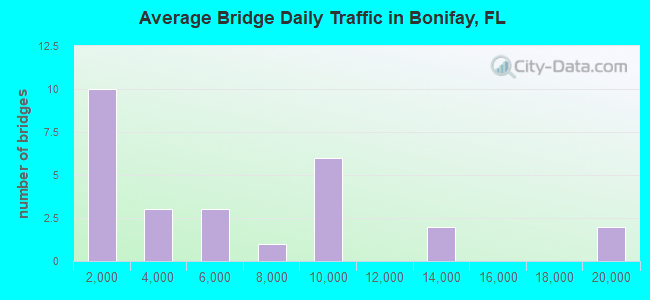
- 152,908Total average daily traffic
- 39,435Total average daily truck traffic
- National Bridge Inventory (NBI) Registered Bridges for Bonifay
- No street view available for this location
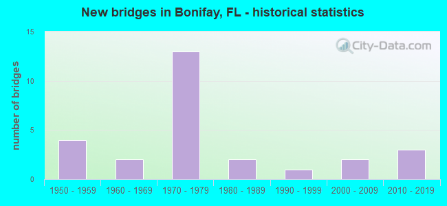
- New bridges - historical statistics
- 41950-1959
- 21960-1969
- 131970-1979
- 21980-1989
- 11990-1999
- 22000-2009
- 32010-2019
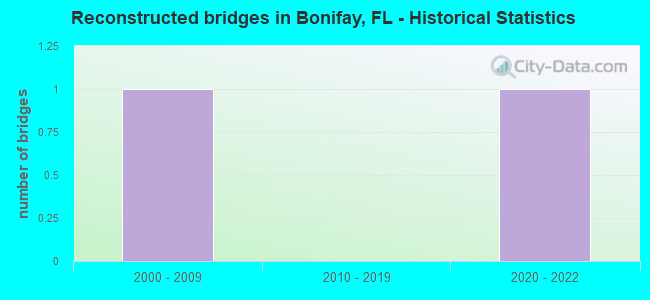
- Reconstructed bridges - Historical Statistics
- 12000-2009
- 02010-2019
- 12020-2022

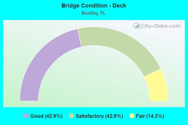
- Bridge Condition - Deck
- 42.9%Good
- 42.9%Satisfactory
- 14.3%Fair
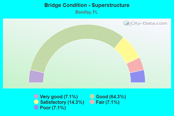
- Bridge Condition - Superstructure
- 7.1%Very good
- 64.3%Good
- 14.3%Satisfactory
- 7.1%Fair
- 7.1%Poor
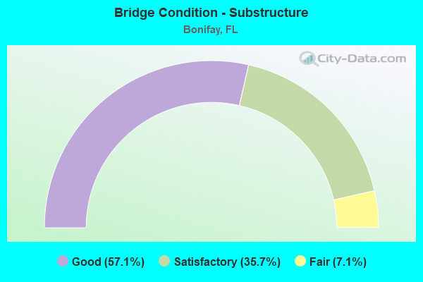
- Bridge Condition - Substructure
- 57.1%Good
- 35.7%Satisfactory
- 7.1%Fair
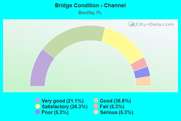
- Bridge Condition - Channel
- 21.1%Very good
- 36.8%Good
- 26.3%Satisfactory
- 5.3%Fair
- 5.3%Poor
- 5.3%Serious
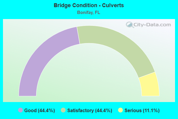
- Bridge Condition - Culverts
- 44.4%Good
- 44.4%Satisfactory
- 11.1%Serious
Find on map >> Show street view
Structure Number: 520002, Location: 2.7mi. West of SR79 (Lat: 30.794614, Lng: -85.723617), Route carried "on" structure: US 90, Year Built: 1954, Status: Open, Structure Length: 1.36m (4.46ft), Average Daily Traffic: 3,200 (year 2020), Truck Traffic: 10%, Average Future Daily Traffic: 5,552 (year 2042), Design Load: H 15, Features Intersected: Gum Creek
Minimum Vertical Clearance: 30+ m (98+ ft), Kilometerpoint: 33.507, Lanes on structure: 2, Base Highway Network: Yes, Owner: State Highway Agency, Approaching Roadway Width: 10.4m (34.1ft), Material/Design: Concrete, Design/Construction: Culvert, Number Of Spans In Main Unit: 4, Length of Maximum Span: 3.0m (9.8ft)
Condition: Channel: Satisfactory, Culverts: Good, Operating Rating: 62.6 metric tons, Method Used To Determine Operating Rating: Load Factor (LF), Inventory Rating: 37.2 metric tons, Method Used To Determine Inventory Rating: Load Factor (LF), Structural Evaluation: Better than present minimum criteria, Waterway Adequacy: Equal to present minimum criteria, Approach Roadway Alignment: Equal to present desirable criteria, Designated Inspection Frequency: Every 24 months, Inspection Date: December 2020
Find on map >> Show street view
Structure Number: 520056, Location: 0.6 miles West of SR79 (Lat: 30.763142, Lng: -85.695997), Route carried "on" structure: County highway 173, Year Built: 1974, Status: Open, Structure Length: 7.42m (24.34ft), Average Daily Traffic: 750 (year 2020), Truck Traffic: 12%, Average Future Daily Traffic: 1,301 (year 2042), Design Load: H 20, Features Intersected: I10 SR8
Minimum Vertical Clearance: 30+ m (98+ ft), Kilometerpoint: 4.184, Lanes on structure: 2, Lanes under structure: 4, Owner: State Highway Agency, Approaching Roadway Width: 6.1m (20.0ft), Skew: 1 degrees, Material/Design: Prestressed concrete, Design/Construction: Stringer/Multi-beam, Number Of Spans In Main Unit: 4, Length of Maximum Span: 27.2m (89.2ft), Curb-To-Curb Width: 9.7m (31.8ft), Out-to-Out Width: 9.7m (31.8ft)
Condition: Deck: Good, Superstructure: Good, Substructure: Good, Operating Rating: 47.0 metric tons, Method Used To Determine Operating Rating: Load and Resistance Factor (LRFR), Inventory Rating: 36.3 metric tons, Method Used To Determine Inventory Rating: Load and Resistance Factor (LRFR), Structural Evaluation: Better than present minimum criteria, Deck Geometry: Equal to present minimum criteria, Underclear: Somewhat better than minimum adequacy, Approach Roadway Alignment: Equal to present desirable criteria, Designated Inspection Frequency: Every 24 months, Inspection Date: July 2021, Deck Structure Type: Concrete Cast-file-Place
Find on map >> Show street view
Structure Number: 520065, Location: 3.1Mi. West of SR79 (Lat: 30.793972, Lng: -85.730611), Route carried "on" structure: US 90, Year Built: 1954, Status: Open, Structure Length: 0.63m (2.07ft), Average Daily Traffic: 3,200 (year 2020), Truck Traffic: 10%, Average Future Daily Traffic: 5,552 (year 2042), Design Load: HS 20+Mod, Features Intersected: Little Gum Creek
Minimum Vertical Clearance: 30+ m (98+ ft), Kilometerpoint: 32.787, Lanes on structure: 2, Base Highway Network: Yes, Owner: State Highway Agency, Approaching Roadway Width: 10.4m (34.1ft), Material/Design: Concrete, Design/Construction: Culvert, Number Of Spans In Main Unit: 2, Length of Maximum Span: 3.0m (9.8ft)
Condition: Channel: Good, Culverts: Good, Operating Rating: 72.6 metric tons, Method Used To Determine Operating Rating: Load Factor (LF), Inventory Rating: 43.5 metric tons, Method Used To Determine Inventory Rating: Load Factor (LF), Structural Evaluation: Better than present minimum criteria, Waterway Adequacy: Better than present minimum criteria, Approach Roadway Alignment: Equal to present desirable criteria, Designated Inspection Frequency: Every 24 months, Inspection Date: December 2020
Find on map >> Show street view
Structure Number: 520066, Location: 1.7Mi. West of SR79 (Lat: 30.791028, Lng: -85.708111), Route carried "on" structure: US 90, Year Built: 1954, Year Reconstructed: 2000, Status: Open, Structure Length: 0.63m (2.07ft), Average Daily Traffic: 5,700 (year 2020), Truck Traffic: 8%, Average Future Daily Traffic: 9,890 (year 2042), Design Load: HS 20+Mod, Features Intersected: Branch
Minimum Vertical Clearance: 30+ m (98+ ft), Kilometerpoint: 35.052, Lanes on structure: 2, Base Highway Network: Yes, Owner: State Highway Agency, Approaching Roadway Width: 10.4m (34.1ft), Material/Design: Concrete, Design/Construction: Culvert, Number Of Spans In Main Unit: 2, Length of Maximum Span: 3.0m (9.8ft)
Condition: Channel: Satisfactory, Culverts: Good, Operating Rating: 75.3 metric tons, Method Used To Determine Operating Rating: Load Factor (LF), Inventory Rating: 45.4 metric tons, Method Used To Determine Inventory Rating: Load Factor (LF), Structural Evaluation: Better than present minimum criteria, Waterway Adequacy: Equal to present minimum criteria, Approach Roadway Alignment: Equal to present desirable criteria, Designated Inspection Frequency: Every 24 months, Inspection Date: December 2020
Find on map >> Show street view
Structure Number: 520075, Location: 1.8Mi South of US90 SR10 (Lat: 30.762611, Lng: -85.684725), Route carried "on" structure: Interstate 10, Year Built: 1974, Status: Open, Structure Length: 6.55m (21.49ft), Average Daily Traffic: 9,150 (year 2020), Truck Traffic: 35%, Average Future Daily Traffic: 15,875 (year 2042), Design Load: HS 20, Features Intersected: SR79
Minimum Vertical Clearance: 30+ m (98+ ft), Kilometerpoint: 27.686, Lanes on structure: 2, Lanes under structure: 5, Base Highway Network: Yes, Owner: State Highway Agency, Approaching Roadway Width: 11.6m (38.1ft), Material/Design: Prestressed concrete, Design/Construction: Stringer/Multi-beam, Number Of Spans In Main Unit: 4, Length of Maximum Span: 21.6m (70.9ft), Curb-To-Curb Width: 12.2m (40.0ft), Out-to-Out Width: 13.1m (43.0ft)
Condition: Deck: Satisfactory, Superstructure: Good, Substructure: Good, Operating Rating: 57.2 metric tons, Method Used To Determine Operating Rating: Load Factor (LF), Inventory Rating: 34.5 metric tons, Method Used To Determine Inventory Rating: Load Factor (LF), Structural Evaluation: Better than present minimum criteria, Deck Geometry: Better than present minimum criteria, Underclear: Superior to present desirable criteria, Approach Roadway Alignment: Equal to present desirable criteria, Designated Inspection Frequency: Every 24 months, Inspection Date: September 2021, Deck Structure Type: Concrete Cast-file-Place
Find on map >> Show street view
Structure Number: 520076, Location: 1.8mi South of US90 SR10 (Lat: 30.762856, Lng: -85.684747), Route carried "on" structure: Interstate 10, Year Built: 1974, Status: Open, Structure Length: 6.45m (21.16ft), Average Daily Traffic: 9,150 (year 2020), Truck Traffic: 35%, Average Future Daily Traffic: 15,875 (year 2042), Design Load: HL 93, Features Intersected: SR79
Minimum Vertical Clearance: 30+ m (98+ ft), Kilometerpoint: 27.686, Lanes on structure: 2, Lanes under structure: 5, Base Highway Network: Yes, Owner: State Highway Agency, Approaching Roadway Width: 11.6m (38.1ft), Material/Design: Prestressed concrete, Design/Construction: Stringer/Multi-beam, Number Of Spans In Main Unit: 4, Length of Maximum Span: 21.7m (71.2ft), Curb-To-Curb Width: 12.2m (40.0ft), Out-to-Out Width: 13.1m (43.0ft)
Condition: Deck: Satisfactory, Superstructure: Good, Substructure: Good, Operating Rating: 50.9 metric tons, Method Used To Determine Operating Rating: Load and Resistance Factor (LRFR), Inventory Rating: 39.3 metric tons, Method Used To Determine Inventory Rating: Load and Resistance Factor (LRFR), Structural Evaluation: Better than present minimum criteria, Deck Geometry: Better than present minimum criteria, Underclear: Better than present minimum criteria, Approach Roadway Alignment: Equal to present desirable criteria, Designated Inspection Frequency: Every 24 months, Inspection Date: September 2021, Deck Structure Type: Concrete Cast-file-Place
Find on map >> Show street view
Structure Number: 520077, Location: 2.2mi. East of SR79 (Lat: 30.759886, Lng: -85.647497), Route carried "on" structure: Interstate 10, Year Built: 1974, Status: Open, Structure Length: 5.49m (18.01ft), Average Daily Traffic: 9,150 (year 2020), Truck Traffic: 35%, Average Future Daily Traffic: 15,875 (year 2042), Design Load: HS 20, Features Intersected: Camp Branch
Minimum Vertical Clearance: 30+ m (98+ ft), Kilometerpoint: 31.299, Lanes on structure: 2, Base Highway Network: Yes, Owner: State Highway Agency, Approaching Roadway Width: 11.6m (38.1ft), Skew: 3 degrees, Material/Design: Prestressed concrete, Design/Construction: Stringer/Multi-beam, Number Of Spans In Main Unit: 4, Length of Maximum Span: 13.7m (44.9ft), Curb-To-Curb Width: 12.2m (40.0ft), Out-to-Out Width: 13.1m (43.0ft)
Condition: Deck: Satisfactory, Superstructure: Very good, Substructure: Satisfactory, Channel: Good, Operating Rating: 47.2 metric tons, Method Used To Determine Operating Rating: Load Factor (LF), Inventory Rating: 28.1 metric tons, Method Used To Determine Inventory Rating: Load Factor (LF), Structural Evaluation: Equal to present minimum criteria, Deck Geometry: Better than present minimum criteria, Waterway Adequacy: Equal to present desirable criteria, Approach Roadway Alignment: Equal to present desirable criteria, Designated Inspection Frequency: Every 24 months, Inspection Date: July 2021, Deck Structure Type: Concrete Cast-file-Place
Find on map >> Show street view
Structure Number: 520078, Location: 2.2mi. East of SR79 (Lat: 30.759586, Lng: -85.647378), Route carried "on" structure: Interstate 10, Year Built: 1974, Status: Open, Structure Length: 5.49m (18.01ft), Average Daily Traffic: 9,150 (year 2020), Truck Traffic: 35%, Average Future Daily Traffic: 15,875 (year 2042), Design Load: HS 20, Features Intersected: Camp Branch
Minimum Vertical Clearance: 30+ m (98+ ft), Kilometerpoint: 31.299, Lanes on structure: 2, Base Highway Network: Yes, Owner: State Highway Agency, Approaching Roadway Width: 11.6m (38.1ft), Skew: 3 degrees, Material/Design: Prestressed concrete, Design/Construction: Stringer/Multi-beam, Number Of Spans In Main Unit: 4, Length of Maximum Span: 13.7m (44.9ft), Curb-To-Curb Width: 12.2m (40.0ft), Out-to-Out Width: 13.1m (43.0ft)
Condition: Deck: Satisfactory, Superstructure: Good, Substructure: Satisfactory, Channel: Good, Operating Rating: 47.2 metric tons, Method Used To Determine Operating Rating: Load Factor (LF), Inventory Rating: 28.1 metric tons, Method Used To Determine Inventory Rating: Load Factor (LF), Structural Evaluation: Equal to present minimum criteria, Deck Geometry: Better than present minimum criteria, Waterway Adequacy: Better than present minimum criteria, Approach Roadway Alignment: Equal to present desirable criteria, Designated Inspection Frequency: Every 24 months, Inspection Date: July 2021, Deck Structure Type: Concrete Cast-file-Place
Find on map >> Show street view
Structure Number: 520079, Location: 3.2mi. East of SR79 (Lat: 30.756661, Lng: -85.629744), Route carried "on" structure: County highway , Year Built: 1975, Status: Open, Structure Length: 7.47m (24.51ft), Average Daily Traffic: 55 (year 2014), Average Future Daily Traffic: 99 (year 2036), Design Load: HS 20, Features Intersected: I10 SR8, Facility Carried by Structure: Holmestead Road
Minimum Vertical Clearance: 30+ m (98+ ft), Kilometerpoint: 1.381, Lanes on structure: 2, Lanes under structure: 4, Owner: State Highway Agency, Approaching Roadway Width: 6.1m (20.0ft), Material/Design: Prestressed concrete, Design/Construction: Stringer/Multi-beam, Number Of Spans In Main Unit: 4, Length of Maximum Span: 26.8m (87.9ft), Curb-To-Curb Width: 9.8m (32.2ft), Out-to-Out Width: 10.4m (34.1ft)
Condition: Deck: Good, Superstructure: Good, Substructure: Good, Operating Rating: 54.1 metric tons, Method Used To Determine Operating Rating: Load Factor (LF), Inventory Rating: 32.4 metric tons, Method Used To Determine Inventory Rating: Load Factor (LF), Structural Evaluation: Better than present minimum criteria, Deck Geometry: Equal to present desirable criteria, Underclear: Somewhat better than minimum adequacy, Approach Roadway Alignment: Equal to present desirable criteria, Designated Inspection Frequency: Every 24 months, Inspection Date: September 2021, Deck Structure Type: Concrete Cast-file-Place
Find on map >> Show street view
Structure Number: 520082, Location: 2.6 Miles North of SR 79 (Lat: 30.855456, Lng: -85.687986), Route carried "on" structure: County highway 177, Year Built: 1977, Status: Open, Structure Length: 3.06m (10.04ft), Average Daily Traffic: 1,800 (year 2019), Truck Traffic: 11%, Average Future Daily Traffic: 2,250 (year 2039), Features Intersected: Gum Creek
Minimum Vertical Clearance: 30+ m (98+ ft), Kilometerpoint: 4.202, Lanes on structure: 2, Owner: County Highway Agency, Approaching Roadway Width: 7.9m (25.9ft), Material/Design: Prestressed concrete, Design/Construction: Slab, Number Of Spans In Main Unit: 3, Length of Maximum Span: 10.2m (33.5ft), Curb-To-Curb Width: 12.1m (39.7ft), Out-to-Out Width: 12.9m (42.3ft)
Condition: Deck: Fair, Superstructure: Fair, Substructure: Satisfactory, Channel: Satisfactory, Operating Rating: 41.7 metric tons, Method Used To Determine Operating Rating: Allowable Stress (AS), Inventory Rating: 28.1 metric tons, Method Used To Determine Inventory Rating: Allowable Stress (AS), Structural Evaluation: Somewhat better than minimum adequacy, Deck Geometry: Equal to present minimum criteria, Waterway Adequacy: Equal to present desirable criteria, Approach Roadway Alignment: Equal to present desirable criteria, Designated Inspection Frequency: Every 24 months, Inspection Date: December 2020, Deck Structure Type: Concrete Precast Panels, Wearing Surface/Protective System: Wearing Surface: Bituminous
Find on map >> Show street view
Structure Number: 520183, Location: 1.9 miles East of SR79 (Lat: 30.782506, Lng: -85.648150), Route carried "on" structure: US 90, Year Built: 2014, Status: Open, Structure Length: 5.24m (17.19ft), Average Daily Traffic: 6,000 (year 2020), Truck Traffic: 12%, Average Future Daily Traffic: 10,410 (year 2042), Design Load: HL 93, Features Intersected: Camp Branch
Minimum Vertical Clearance: 30+ m (98+ ft), Kilometerpoint: 40.927, Lanes on structure: 2, Base Highway Network: Yes, Owner: State Highway Agency, Approaching Roadway Width: 10.4m (34.1ft), Material/Design: Prestressed concrete, Design/Construction: Stringer/Multi-beam, Number Of Spans In Main Unit: 2, Length of Maximum Span: 26.2m (86.0ft), Curb-To-Curb Width: 13.4m (44.0ft), Out-to-Out Width: 14.4m (47.2ft)
Condition: Deck: Good, Superstructure: Good, Substructure: Good, Channel: Very good, Operating Rating: 41.8 metric tons, Method Used To Determine Operating Rating: Load and Resistance Factor (LRFR), Inventory Rating: 36.3 metric tons, Method Used To Determine Inventory Rating: Load and Resistance Factor (LRFR), Structural Evaluation: Better than present minimum criteria, Deck Geometry: Equal to present minimum criteria, Waterway Adequacy: Superior to present desirable criteria, Approach Roadway Alignment: Equal to present desirable criteria, Designated Inspection Frequency: Every 24 months, Inspection Date: April 2020, Deck Structure Type: Concrete Cast-file-Place
Find on map >> Show street view
Structure Number: 52402, Location: 0.4 Mi North of US90/SR10 (Lat: 30.792653, Lng: -85.658933), Route carried "on" structure: Other road , Year Built: 1981, Status: Posted for load, Structure Length: 0.79m (2.59ft), Average Daily Traffic: 36 (year 2020), Average Future Daily Traffic: 40 (year 2040), Design Load: HL 93, Features Intersected: Unnamed Branch, Facility Carried by Structure: Joe White Road
Minimum Vertical Clearance: 30+ m (98+ ft), Kilometerpoint: 0.629, Lanes on structure: 1, Owner: County Highway Agency, Approaching Roadway Width: 4.3m (14.1ft), Material/Design: Wood or Timber, Design/Construction: Stringer/Multi-beam, Number Of Spans In Main Unit: 2, Length of Maximum Span: 4.1m (13.5ft), Curb-To-Curb Width: 4.3m (14.1ft), Out-to-Out Width: 4.9m (16.1ft)
Condition: Deck: Fair, Superstructure: Good, Substructure: Fair, Channel: Satisfactory, Operating Rating: 16.3 metric tons, Method Used To Determine Operating Rating: Load and Resistance Factor (LRFR), Inventory Rating: 12.7 metric tons, Method Used To Determine Inventory Rating: Load and Resistance Factor (LRFR), Structural Evaluation: Meets minimum limits, Deck Geometry: Equal to present minimum criteria, Waterway Adequacy: Better than present minimum criteria, Approach Roadway Alignment: Equal to present desirable criteria, Bridge Posting: Required (Relationship of Operating Rating to Maximum Legal Load: 30.0 - 39.9% below), Designated Inspection Frequency: Every 24 months, Other Special Inspection Frequency: Every 12 months, Inspection Date: January 2021, Other Special Inspection Date: January 2022, Deck Structure Type: Wood or Timber, Wearing Surface/Protective System: Wearing Surface: Wood or Timber
Find on map >> Show street view
Structure Number: 524023, Location: 1.46 Miles East of SR 79 (Lat: 30.751700, Lng: -85.668233), Route carried "on" structure: County highway , Year Built: 1992, Year Reconstructed: 2020, Status: Open, Structure Length: 1.40m (4.59ft), Average Daily Traffic: 900 (year 2020), Truck Traffic: 12%, Average Future Daily Traffic: 990 (year 2040), Design Load: HL 93, Features Intersected: Open Creek, Facility Carried by Structure: Thomas Drive
Minimum Vertical Clearance: 30+ m (98+ ft), Kilometerpoint: 2.358, Lanes on structure: 2, Owner: County Highway Agency, Approaching Roadway Width: 6.9m (22.6ft), Material/Design: Steel, Design/Construction: Stringer/Multi-beam, Number Of Spans In Main Unit: 3, Length of Maximum Span: 4.6m (15.1ft), Curb-To-Curb Width: 7.0m (23.0ft), Out-to-Out Width: 7.6m (24.9ft)
Condition: Deck: Good, Superstructure: Good, Substructure: Good, Channel: Good, Structural Evaluation: Better than present minimum criteria, Deck Geometry: Meets minimum limits, Waterway Adequacy: Better than present minimum criteria, Approach Roadway Alignment: Equal to present desirable criteria, Designated Inspection Frequency: Every 24 months, Underwater Inspection Frequency: Every 12 months, Other Special Inspection Frequency: Every 12 months, Inspection Date: December 2020, Underwater Inspection Date: December 2021, Other Special Inspection Date: December 2021, Deck Structure Type: Steel plate
Find on map >> Show street view
Structure Number: 524176, Location: 1.4 Miles East of SR 79 (Lat: 30.794000, Lng: -85.656139), Route carried "on" structure: Other road , Year Built: 2012, Status: Open, Structure Length: 0.87m (2.85ft), Average Daily Traffic: 40 (year 2019), Average Future Daily Traffic: 44 (year 2039), Design Load: HL 93, Features Intersected: Camp Branch, Facility Carried by Structure: Bonifay Chipley Rd
Minimum Vertical Clearance: 30+ m (98+ ft), Kilometerpoint: 2.251, Lanes on structure: 2, Owner: County Highway Agency, Approaching Roadway Width: 6.5m (21.3ft), Material/Design: Concrete, Design/Construction: Culvert, Number Of Spans In Main Unit: 3, Length of Maximum Span: 3.0m (9.8ft), Curb-To-Curb Width: 7.4m (24.3ft), Out-to-Out Width: 8.3m (27.2ft)
Condition: Channel: Fair, Culverts: Good, Operating Rating: 54.9 metric tons, Method Used To Determine Operating Rating: Load and Resistance Factor (LRFR), Inventory Rating: 42.1 metric tons, Method Used To Determine Inventory Rating: Load and Resistance Factor (LRFR), Structural Evaluation: Better than present minimum criteria, Deck Geometry: Equal to present minimum criteria, Waterway Adequacy: Better than present minimum criteria, Approach Roadway Alignment: Equal to present desirable criteria, Designated Inspection Frequency: Every 24 months, Inspection Date: November 2020
Find on map >> Show street view
Structure Number: 524503, Location: 1.9 Mi West of SR79 (Lat: 30.808403, Lng: -85.709278), Route carried "on" structure: County highway 177A, Year Built: 1965, Status: Open, Structure Length: 0.63m (2.07ft), Average Daily Traffic: 1,700 (year 2019), Truck Traffic: 17%, Average Future Daily Traffic: 1,870 (year 2039), Design Load: HS 20, Features Intersected: Bear Bay Branch
Minimum Vertical Clearance: 30+ m (98+ ft), Kilometerpoint: 3.169, Lanes on structure: 2, Owner: County Highway Agency, Approaching Roadway Width: 6.7m (22.0ft), Material/Design: Concrete, Design/Construction: Culvert, Number Of Spans In Main Unit: 2, Length of Maximum Span: 3.1m (10.2ft)
Condition: Channel: Good, Culverts: Satisfactory, Operating Rating: 80.7 metric tons, Method Used To Determine Operating Rating: Load Factor (LF), Inventory Rating: 48.1 metric tons, Method Used To Determine Inventory Rating: Load Factor (LF), Structural Evaluation: Equal to present minimum criteria, Waterway Adequacy: Better than present minimum criteria, Approach Roadway Alignment: Equal to present minimum criteria, Designated Inspection Frequency: Every 24 months, Inspection Date: March 2021
Find on map >> Show street view
Structure Number: 610001, Location: 3.0Mi. West of SR277 (Lat: 30.778586, Lng: -85.615833), Route carried "on" structure: US 90, Year Built: 1953, Status: Open, Structure Length: 14.08m (46.19ft), Average Daily Traffic: 4,152 (year 2020), Truck Traffic: 8%, Average Future Daily Traffic: 7,204 (year 2042), Design Load: HS 20, Features Intersected: Holmes Creek
Minimum Vertical Clearance: 30+ m (98+ ft), Kilometerpoint: 21.453, Lanes on structure: 2, Base Highway Network: Yes, Owner: State Highway Agency, Approaching Roadway Width: 10.4m (34.1ft), Material/Design: Concrete, Design/Construction: Tee Beam, Number Of Spans In Main Unit: 14, Length of Maximum Span: 10.1m (33.1ft), Curb-To-Curb Width: 10.6m (34.8ft), Out-to-Out Width: 11.4m (37.4ft)
Condition: Deck: Satisfactory, Superstructure: Poor, Substructure: Satisfactory, Channel: Very good, Operating Rating: 39.9 metric tons, Method Used To Determine Operating Rating: Load Factor (LF), Inventory Rating: 23.6 metric tons, Method Used To Determine Inventory Rating: Load Factor (LF), Structural Evaluation: Meets minimum limits, Deck Geometry: Somewhat better than minimum adequacy, Waterway Adequacy: Equal to present desirable criteria, Approach Roadway Alignment: Equal to present desirable criteria, Designated Inspection Frequency: Every 24 months, Other Special Inspection Frequency: Every 12 months, Inspection Date: August 2021, Other Special Inspection Date: August 2021, Deck Structure Type: Concrete Cast-file-Place
Find on map >> Show street view
Structure Number: 610026, Location: 0.5Mi N of Bess Nook Rd (Lat: 30.731056, Lng: -85.737286), Route carried "on" structure: County highway 173, Year Built: 1964, Status: Open, Structure Length: 1.35m (4.43ft), Average Daily Traffic: 650 (year 2020), Truck Traffic: 10%, Average Future Daily Traffic: 1,128 (year 2042), Features Intersected: Gum Creek No. 2
Minimum Vertical Clearance: 30+ m (98+ ft), Kilometerpoint: 2.746, Lanes on structure: 2, Owner: County Highway Agency, Approaching Roadway Width: 6.8m (22.3ft), Skew: 1 degrees, Material/Design: Concrete, Design/Construction: Culvert, Number Of Spans In Main Unit: 4, Length of Maximum Span: 3.5m (11.5ft)
Condition: Channel: Serious, Culverts: Serious, Operating Rating: 65.0 metric tons, Method Used To Determine Operating Rating: Load and Resistance Factor (LRFR), Inventory Rating: 50.3 metric tons, Method Used To Determine Inventory Rating: Load and Resistance Factor (LRFR), Structural Evaluation: High priority of corrective action, Waterway Adequacy: Better than present minimum criteria, Approach Roadway Alignment: Equal to present minimum criteria, Designated Inspection Frequency: Every 24 months, Underwater Inspection Frequency: Every 6 months, Other Special Inspection Frequency: Every 6 months, Inspection Date: November 2020, Underwater Inspection Date: November 2021, Other Special Inspection Date: November 2021
Find on map >> Show street view
Structure Number: 610054, Location: 4.3mi. East of CR279 (Lat: 30.760917, Lng: -85.741806), Route carried "on" structure: Interstate 10, Year Built: 1974, Status: Open, Structure Length: 0.87m (2.85ft), Average Daily Traffic: 9,350 (year 2020), Truck Traffic: 37%, Average Future Daily Traffic: 16,222 (year 2042), Design Load: HS 20, Features Intersected: Gum Creek
Minimum Vertical Clearance: 30+ m (98+ ft), Kilometerpoint: 8.764, Lanes on structure: 2, Base Highway Network: Yes, Owner: State Highway Agency, Approaching Roadway Width: 11.6m (38.1ft), Material/Design: Concrete, Design/Construction: Culvert, Number Of Spans In Main Unit: 3, Length of Maximum Span: 2.7m (8.9ft)
Condition: Channel: Satisfactory, Culverts: Satisfactory, Structural Evaluation: Equal to present minimum criteria, Waterway Adequacy: Equal to present desirable criteria, Approach Roadway Alignment: Equal to present desirable criteria, Designated Inspection Frequency: Every 24 months, Inspection Date: June 2021
Find on map >> Show street view
Structure Number: 610055, Location: 4.3mi. East of CR279 (Lat: 30.759667, Lng: -85.741806), Route carried "on" structure: Interstate 10, Year Built: 1974, Status: Open, Structure Length: 0.87m (2.85ft), Average Daily Traffic: 9,350 (year 2020), Truck Traffic: 37%, Average Future Daily Traffic: 16,222 (year 2042), Design Load: HS 20, Features Intersected: Gum Creek
Minimum Vertical Clearance: 30+ m (98+ ft), Kilometerpoint: 8.774, Lanes on structure: 2, Base Highway Network: Yes, Owner: State Highway Agency, Approaching Roadway Width: 11.6m (38.1ft), Material/Design: Concrete, Design/Construction: Culvert, Number Of Spans In Main Unit: 3, Length of Maximum Span: 2.7m (8.9ft)
Condition: Channel: Good, Culverts: Satisfactory, Structural Evaluation: Equal to present minimum criteria, Waterway Adequacy: Equal to present desirable criteria, Approach Roadway Alignment: Equal to present desirable criteria, Designated Inspection Frequency: Every 24 months, Inspection Date: June 2021
Find on map >> Show street view
Structure Number: 610148, Location: 1.5 Miles S. of I10 SR8 (Lat: 30.740153, Lng: -85.685156), Route carried "on" structure: State highway 79, Year Built: 2008, Status: Open, Structure Length: 3.90m (12.80ft), Average Daily Traffic: 5,000 (year 2020), Truck Traffic: 11%, Average Future Daily Traffic: 8,675 (year 2042), Design Load: HS 20, Features Intersected: Open Creek
Minimum Vertical Clearance: 30+ m (98+ ft), Kilometerpoint: 45.633, Lanes on structure: 2, Base Highway Network: Yes, Owner: State Highway Agency, Approaching Roadway Width: 10.4m (34.1ft), Material/Design: Concrete, Design/Construction: Slab, Number Of Spans In Main Unit: 4, Length of Maximum Span: 9.8m (32.2ft), Curb-To-Curb Width: 13.4m (44.0ft), Out-to-Out Width: 14.4m (47.2ft)
Condition: Deck: Good, Superstructure: Good, Substructure: Good, Channel: Very good, Operating Rating: 80.2 metric tons, Method Used To Determine Operating Rating: Load Factor (LF), Inventory Rating: 48.1 metric tons, Method Used To Determine Inventory Rating: Load Factor (LF), Structural Evaluation: Better than present minimum criteria, Deck Geometry: Superior to present desirable criteria, Waterway Adequacy: Equal to present desirable criteria, Approach Roadway Alignment: Equal to present desirable criteria, Designated Inspection Frequency: Every 24 months, Inspection Date: Febuary 2022, Deck Structure Type: Concrete Cast-file-Place
Find on map >> Show street view
Structure Number: 610154, Location: 4.1 Miles South of I10 (Lat: 30.703139, Lng: -85.686056), Route carried "on" structure: State highway 79, Year Built: 2017, Status: Open, Structure Length: 0.67m (2.20ft), Average Daily Traffic: 3,300 (year 2016), Truck Traffic: 9%, Average Future Daily Traffic: 5,799 (year 2037), Design Load: HL 93, Features Intersected: Stream
Minimum Vertical Clearance: 30+ m (98+ ft), Kilometerpoint: 41.553, Lanes on structure: 4, Base Highway Network: Yes, Owner: State Highway Agency, Approaching Roadway Width: 7.9m (25.9ft), Skew: 10 degrees, Material/Design: Concrete, Design/Construction: Culvert, Number Of Spans In Main Unit: 2, Length of Maximum Span: 3.0m (9.8ft)
Condition: Channel: Very good, Culverts: Satisfactory, Structural Evaluation: Equal to present minimum criteria, Waterway Adequacy: Equal to present desirable criteria, Approach Roadway Alignment: Equal to present desirable criteria, Designated Inspection Frequency: Every 24 months, Inspection Date: March 2021
Find on map >> Show street view
Structure Number: 614139, Location: 2.2 Mi East of Hwy 90 (Lat: 30.770369, Lng: -85.740311), Route carried "on" structure: County highway , Year Built: 1984, Status: Posted for load, Structure Length: 0.92m (3.02ft), Average Daily Traffic: 50 (year 2021), Average Future Daily Traffic: 87 (year 2042), Design Load: HS 20, Features Intersected: Gum Creek, Facility Carried by Structure: Sandpath Road
Minimum Vertical Clearance: 30+ m (98+ ft), Kilometerpoint: 3.330, Lanes on structure: 1, Owner: County Highway Agency, Approaching Roadway Width: 4.6m (15.1ft), Material/Design: Wood or Timber, Design/Construction: Stringer/Multi-beam, Number Of Spans In Main Unit: 2, Length of Maximum Span: 4.7m (15.4ft), Curb-To-Curb Width: 5.0m (16.4ft), Out-to-Out Width: 5.0m (16.4ft)
Condition: Deck: Good, Superstructure: Satisfactory, Substructure: Satisfactory, Channel: Poor, Operating Rating: 26.3 metric tons, Method Used To Determine Operating Rating: Allowable Stress (AS), Inventory Rating: 19.1 metric tons, Method Used To Determine Inventory Rating: Allowable Stress (AS), Structural Evaluation: Somewhat better than minimum adequacy, Deck Geometry: High priority of corrective action, Waterway Adequacy: Equal to present minimum criteria, Approach Roadway Alignment: Equal to present minimum criteria, Bridge Posting: Required (Relationship of Operating Rating to Maximum Legal Load: 20.0 - 29.9% below), Designated Inspection Frequency: Every 24 months, Underwater Inspection Frequency: Every 12 months, Other Special Inspection Frequency: Every 12 months, Inspection Date: September 2020, Underwater Inspection Date: September 2021, Other Special Inspection Date: September 2021, Deck Structure Type: Wood or Timber
Find on map >> Show street view
Structure Number: 614144, Location: 0.25 Mi North of SR 173 (Lat: 30.738714, Lng: -85.736103), Route carried "on" structure: County highway , Year Built: 2002, Status: Posted for load, Structure Length: 0.94m (3.08ft), Average Daily Traffic: 75 (year 2021), Average Future Daily Traffic: 130 (year 2042), Features Intersected: Gum Creek, Facility Carried by Structure: King Road
Minimum Vertical Clearance: 30+ m (98+ ft), Kilometerpoint: 1.342, Lanes on structure: 1, Owner: County Highway Agency, Approaching Roadway Width: 4.0m (13.1ft), Material/Design: Wood or Timber, Design/Construction: Stringer/Multi-beam, Number Of Spans In Main Unit: 2, Length of Maximum Span: 4.7m (15.4ft), Curb-To-Curb Width: 5.0m (16.4ft), Out-to-Out Width: 5.0m (16.4ft)
Condition: Deck: Satisfactory, Superstructure: Satisfactory, Substructure: Good, Channel: Good, Operating Rating: 28.1 metric tons, Method Used To Determine Operating Rating: Allowable Stress (AS), Inventory Rating: 20.0 metric tons, Method Used To Determine Inventory Rating: Allowable Stress (AS), Structural Evaluation: Somewhat better than minimum adequacy, Deck Geometry: High priority of corrective action, Waterway Adequacy: Equal to present minimum criteria, Approach Roadway Alignment: Equal to present desirable criteria, Bridge Posting: Required (Relationship of Operating Rating to Maximum Legal Load: 10.0 - 19.9% below), Designated Inspection Frequency: Every 24 months, Other Special Inspection Frequency: Every 12 months, Inspection Date: July 2020, Other Special Inspection Date: July 2021, Deck Structure Type: Wood or Timber
Find on map >> Show street view
Structure Number: 520056, Location: 0.6 miles West of SR79 (Lat: 30.763142, Lng: -85.695997), Route carried "under" structure: Interstate 10, Year Built: 1974, Structure Length: 0. m, Average Daily Traffic: 18,700 (year 2020), Truck Traffic: 37%, Features Intersected: I10 SR8, Facility Carried by Structure: CR173
Minimum Vertical Clearance: 5.00m (16.40ft), Kilometerpoint: 26.630, Lanes on structure: 2, Lanes under structure: 4, Material/Design: Prestressed concrete, Design/Construction: Stringer/Multi-beam, Length of Maximum Span: 27.2m (89.2ft)
Find on map >> Show street view
Structure Number: 520075, Location: 1.8Mi South of US90 SR10 (Lat: 30.762611, Lng: -85.684725), Route carried "under" structure: State highway 79, Year Built: 1974, Structure Length: 0. m, Average Daily Traffic: 12,000 (year 2020), Truck Traffic: 11%, Features Intersected: SR79, Facility Carried by Structure: I10 SR8
Minimum Vertical Clearance: 5.27m (17.29ft), Kilometerpoint: 1.999, Lanes on structure: 2, Lanes under structure: 5, Material/Design: Prestressed concrete, Design/Construction: Stringer/Multi-beam, Length of Maximum Span: 21.6m (70.9ft)
Find on map >> Show street view
Structure Number: 520076, Location: 1.8mi South of US90 SR10 (Lat: 30.762856, Lng: -85.684747), Route carried "under" structure: State highway 79, Year Built: 1974, Structure Length: 0. m, Average Daily Traffic: 12,000 (year 2020), Truck Traffic: 11%, Features Intersected: SR79, Facility Carried by Structure: I10 SR8
Minimum Vertical Clearance: 4.88m (16.01ft), Kilometerpoint: 2.026, Lanes on structure: 2, Lanes under structure: 5, Material/Design: Prestressed concrete, Design/Construction: Stringer/Multi-beam, Length of Maximum Span: 21.7m (71.2ft)
Find on map >> Show street view
Structure Number: 520079, Location: 3.2mi. East of SR79 (Lat: 30.756661, Lng: -85.629744), Route carried "under" structure: Interstate 10, Year Built: 1975, Structure Length: 0. m, Average Daily Traffic: 18,300 (year 2020), Truck Traffic: 35%, Features Intersected: I10 SR8, Facility Carried by Structure: Holmestead Road
Minimum Vertical Clearance: 4.82m (15.81ft), Kilometerpoint: 33.048, Lanes on structure: 2, Lanes under structure: 4, Material/Design: Prestressed concrete, Design/Construction: Stringer/Multi-beam, Length of Maximum Span: 26.8m (87.9ft)