Bridge Statistics for Bowers, Pennsylvania (PA)
Condition, Traffic, Stress, Structural Evaluation, Project Costs
- National Bridge Inventory (NBI) Statistics
- 11Number of bridges
- 69ft / 21.2mTotal length
- $1,125,000Total costs
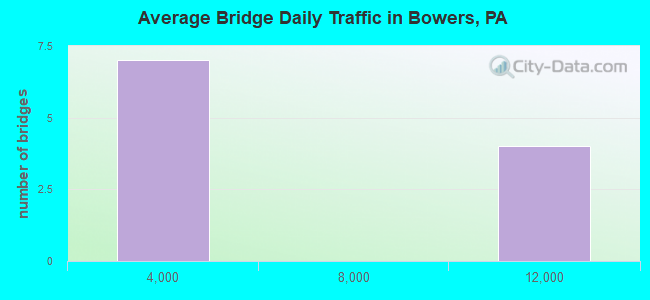
- 43,845Total average daily traffic
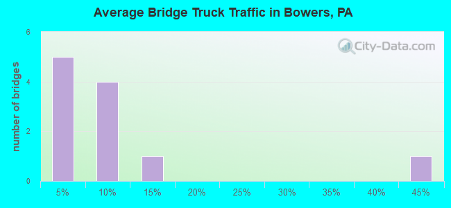
- 3,883Total average daily truck traffic
- 56,895Total future (year 2005) average daily traffic
- National Bridge Inventory (NBI) Registered Bridges for Bowers
- No street view available for this location
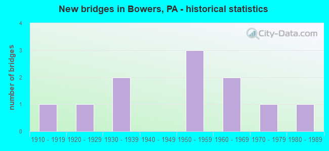
- New bridges - historical statistics
- 11910-1919
- 11920-1929
- 21930-1939
- 31950-1959
- 21960-1969
- 11970-1979
- 11980-1989
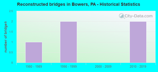
- Reconstructed bridges - Historical Statistics
- 11980-1989
- 21990-1999
- 02000-2009
- 22010-2019
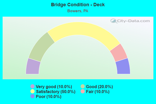
- Bridge Condition - Deck
- 10.0%Very good
- 20.0%Good
- 50.0%Satisfactory
- 10.0%Fair
- 10.0%Poor
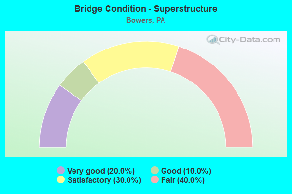
- Bridge Condition - Superstructure
- 20.0%Very good
- 10.0%Good
- 30.0%Satisfactory
- 40.0%Fair
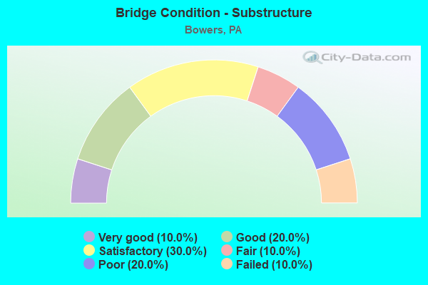
- Bridge Condition - Substructure
- 10.0%Very good
- 20.0%Good
- 30.0%Satisfactory
- 10.0%Fair
- 20.0%Poor
- 10.0%Failed
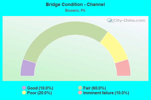
- Bridge Condition - Channel
- 10.0%Good
- 60.0%Fair
- 20.0%Poor
- 10.0%Imminent failure
Find on map >> Show street view
Structure Number: 3094, Location: KIMMEL SCHOOL (Lat: 40.677417, Lng: -79.325514), Route carried "on" structure: US 422, Year Built: 1958, Year Reconstructed: 2010, Status: Open, Structure Length: 5.18m (16.99ft), Average Daily Traffic: 11,203 (year 2022), Truck Traffic: 13%, Average Future Daily Traffic: 12,078 (year 2032), Design Load: HL 93, Features Intersected: PLUM CREEK
Minimum Vertical Clearance: 30+ m (98+ ft), Kilometerpoint: 40.525, Lanes on structure: 2, Base Highway Network: Yes, Owner: State Highway Agency, Approaching Roadway Width: 11.9m (39.0ft), Skew: 4 degrees, Material/Design: Prestressed concrete continuous, Design/Construction: Box Beam or Girders - Single/Spread, Number Of Spans In Main Unit: 2, Length of Maximum Span: 25.0m (82.0ft), Curb or Sidewalk Widths: Left: 0.2m (0.7ft), Right: 0.2m (0.7ft), Curb-To-Curb Width: 12.2m (40.0ft), Out-to-Out Width: 13.2m (43.3ft)
Condition: Deck: Good, Superstructure: Very good, Substructure: Satisfactory, Channel: Fair, Operating Rating: 62.6 metric tons, Method Used To Determine Operating Rating: Load and Resistance Factor (LRFR), Inventory Rating: 41.7 metric tons, Method Used To Determine Inventory Rating: Load and Resistance Factor (LRFR), Structural Evaluation: Equal to present minimum criteria, Deck Geometry: Somewhat better than minimum adequacy, Waterway Adequacy: Equal to present minimum criteria, Approach Roadway Alignment: Equal to present desirable criteria, Length Of Structure Improvement: 6.10m (20.01ft), Designated Inspection Frequency: Every 24 months, Inspection Date: October 2021, Bridge Improvement Cost: $50,000, Roadway Improvement Cost: $146,000, Total Project Cost: $670,000, Deck Structure Type: Concrete Cast-file-Place, Wearing Surface/Protective System: Wearing Surface: Monolithic Concrete, Deck Protection: Epoxy Coated Reinforcing
Find on map >> Show street view
Structure Number: 497, Location: VILLAGE OF BOWERS (Lat: 40.483200, Lng: -75.739469), Route carried "on" structure: State highway , Year Built: 1958, Status: Open, Structure Length: 1.52m (4.99ft), Average Daily Traffic: 9,260 (year 2022), Truck Traffic: 7%, Average Future Daily Traffic: 10,818 (year 2032), Design Load: HS 20, Features Intersected: TRIB.SACONY CREEK, Facility Carried by Structure: SR 1010 (LR 06119)
Minimum Vertical Clearance: 30+ m (98+ ft), Kilometerpoint: 16.344, Lanes on structure: 2, Base Highway Network: Yes, Owner: State Highway Agency, Approaching Roadway Width: 10.4m (34.1ft), Skew: 1 degrees, Material/Design: Concrete, Design/Construction: Tee Beam, Number Of Spans In Main Unit: 2, Length of Maximum Span: 7.0m (23.0ft), Curb-To-Curb Width: 12.2m (40.0ft), Out-to-Out Width: 13.4m (44.0ft)
Condition: Deck: Satisfactory, Superstructure: Satisfactory, Substructure: Satisfactory, Channel: Fair, Operating Rating: 55.3 metric tons, Method Used To Determine Operating Rating: Load Factor (LF), Inventory Rating: 33.6 metric tons, Method Used To Determine Inventory Rating: Load Factor (LF), Structural Evaluation: Equal to present minimum criteria, Deck Geometry: Somewhat better than minimum adequacy, Waterway Adequacy: Equal to present minimum criteria, Approach Roadway Alignment: Equal to present desirable criteria, Length Of Structure Improvement: 2.20m (7.22ft), Designated Inspection Frequency: Every 24 months, Inspection Date: July 2020, Bridge Improvement Cost: $12,000, Roadway Improvement Cost: $35,000, Total Project Cost: $160,000, Deck Structure Type: Concrete Cast-file-Place, Wearing Surface/Protective System: Wearing Surface: Bituminous
Find on map >> Show street view
Structure Number: 4971, Location: FLEETWOOD ROAD (Lat: 40.489689, Lng: -75.723314), Route carried "on" structure: State highway , Year Built: 1958, Status: Open, Structure Length: 1.07m (3.51ft), Average Daily Traffic: 9,260 (year 2022), Truck Traffic: 7%, Average Future Daily Traffic: 10,818 (year 2032), Design Load: HS 20, Features Intersected: TRIB.TO SACONY CREEK, Facility Carried by Structure: SR 1010 (LR 06119)
Minimum Vertical Clearance: 30+ m (98+ ft), Kilometerpoint: 17.833, Lanes on structure: 2, Base Highway Network: Yes, Owner: State Highway Agency, Approaching Roadway Width: 6.7m (22.0ft), Skew: 4 degrees, Material/Design: Concrete, Design/Construction: Tee Beam, Number Of Spans In Main Unit: 1, Length of Maximum Span: 10.4m (34.1ft), Curb-To-Curb Width: 12.2m (40.0ft), Out-to-Out Width: 13.3m (43.6ft)
Condition: Deck: Satisfactory, Superstructure: Satisfactory, Substructure: Good, Channel: Fair, Operating Rating: 76.2 metric tons, Method Used To Determine Operating Rating: Load Factor (LF), Inventory Rating: 45.4 metric tons, Method Used To Determine Inventory Rating: Load Factor (LF), Structural Evaluation: Equal to present minimum criteria, Deck Geometry: Somewhat better than minimum adequacy, Waterway Adequacy: Equal to present minimum criteria, Approach Roadway Alignment: Equal to present desirable criteria, Length Of Structure Improvement: 1.80m (5.91ft), Designated Inspection Frequency: Every 24 months, Inspection Date: June 2020, Deck Structure Type: Concrete Cast-file-Place, Wearing Surface/Protective System: Wearing Surface: Bituminous
Find on map >> Show street view
Structure Number: 502, Location: SMOKETOWN ROAD (Lat: 40.477981, Lng: -75.731858), Route carried "on" structure: State highway , Year Built: 1938, Year Reconstructed: 2017, Status: Closed, Structure Length: 1.16m (3.81ft), Average Daily Traffic: 770 (year 2022), Truck Traffic: 1%, Average Future Daily Traffic: 636 (year 2036), Design Load: HL 93, Features Intersected: LITTLE SACONY CREEK, Facility Carried by Structure: SR 1029 (LR 06158)
Minimum Vertical Clearance: 30+ m (98+ ft), Kilometerpoint: 2.279, Lanes on structure: 2, Owner: State Highway Agency, Approaching Roadway Width: 6.7m (22.0ft), Skew: 3 degrees, Material/Design: Steel, Design/Construction: Stringer/Multi-beam, Number Of Spans In Main Unit: 1, Length of Maximum Span: 11.0m (36.1ft), Curb or Sidewalk Widths: Left: 0.5m (1.6ft), Right: 0.5m (1.6ft), Curb-To-Curb Width: 6.7m (22.0ft), Out-to-Out Width: 7.7m (25.3ft)
Condition: Deck: Very good, Superstructure: Very good, Substructure: Failed, Channel: Imminent failure, Operating Rating: 48.6 metric tons, Method Used To Determine Operating Rating: Assigned ratings based on Load and Resistance Factor Design (LRFD) reported by rating factor (RF) using HL93 loadings, Inventory Rating: 37.3 metric tons, Method Used To Determine Inventory Rating: Assigned ratings based on Load and Resistance Factor Design (LRFD) reported by rating factor (RF) using HL93 loadings, Deck Geometry: Meets minimum limits, Waterway Adequacy: Better than present minimum criteria, Approach Roadway Alignment: Better than present minimum criteria, Length Of Structure Improvement: 1.80m (5.91ft), Designated Inspection Frequency: Every 24 months, Inspection Date: November 2021, Bridge Improvement Cost: $3,000, Roadway Improvement Cost: $9,000, Total Project Cost: $42,000, Deck Structure Type: Closed Grating, Wearing Surface/Protective System: Wearing Surface: Monolithic Concrete, Deck Protection: Epoxy Coated Reinforcing
Find on map >> Show street view
Structure Number: 5398, Location: VILLAGE OF BOWERS (Lat: 40.483444, Lng: -75.741708), Route carried "on" structure: City street , Year Built: 1930, Status: Posted for load, Structure Length: 1.07m (3.51ft), Average Daily Traffic: 500 (year 1979), Truck Traffic: 1%, Average Future Daily Traffic: 700 (year 2005), Features Intersected: SACONY CREEK, Facility Carried by Structure: BOWERS ROAD
Minimum Vertical Clearance: 30+ m (98+ ft), Kilometerpoint: 0.000, Lanes on structure: 2, Owner: Town or Township Highway Agency, Approaching Roadway Width: 6.1m (20.0ft), Material/Design: Concrete, Design/Construction: Slab, Number Of Spans In Main Unit: 2, Length of Maximum Span: 4.9m (16.1ft), Curb-To-Curb Width: 5.4m (17.7ft), Out-to-Out Width: 6.2m (20.3ft)
Condition: Deck: Fair, Superstructure: Fair, Substructure: Poor, Channel: Poor, Operating Rating: 68.0 metric tons, Method Used To Determine Operating Rating: Field evaluation and documented engineering judgment, Inventory Rating: 40.8 metric tons, Method Used To Determine Inventory Rating: Field evaluation and documented engineering judgment, Structural Evaluation: Meets minimum limits, Deck Geometry: High priority of replacement, Waterway Adequacy: Equal to present minimum criteria, Approach Roadway Alignment: Equal to present desirable criteria, Length Of Structure Improvement: 1.80m (5.91ft), Designated Inspection Frequency: Every 24 months, Other Special Inspection Frequency: Every 12 months, Inspection Date: October 2020, Other Special Inspection Date: October 2021, Bridge Improvement Cost: $5,000, Roadway Improvement Cost: $15,000, Total Project Cost: $70,000, Deck Structure Type: Concrete Cast-file-Place, Wearing Surface/Protective System: Wearing Surface: Bituminous
Find on map >> Show street view
Structure Number: 22529, Location: 037015 NORTH BEAVER TWP (Lat: 40.978411, Lng: -80.469036), Route carried "on" structure: City street , Year Built: 1961, Status: Open, Structure Length: 1.83m (6.00ft), Average Daily Traffic: 200 (year 2005), Truck Traffic: 40%, Average Future Daily Traffic: 200 (year 2025), Design Load: HS 20, Features Intersected: HICKORY CREEK, Facility Carried by Structure: SMALLS FERRY RD
Minimum Vertical Clearance: 30+ m (98+ ft), Kilometerpoint: 0.000, Lanes on structure: 2, Owner: County Highway Agency, Approaching Roadway Width: 5.8m (19.0ft), Material/Design: Prestressed concrete, Design/Construction: Box Beam or Girders - Multiple, Number Of Spans In Main Unit: 1, Length of Maximum Span: 17.7m (58.1ft), Curb or Sidewalk Widths: Left: 0.5m (1.6ft), Right: 0.5m (1.6ft), Curb-To-Curb Width: 8.5m (27.9ft), Out-to-Out Width: 10.2m (33.5ft)
Condition: Deck: Satisfactory, Superstructure: Satisfactory, Substructure: Good, Channel: Fair, Operating Rating: 70.8 metric tons, Method Used To Determine Operating Rating: Load Factor (LF), Inventory Rating: 27.2 metric tons, Method Used To Determine Inventory Rating: Load Factor (LF), Structural Evaluation: Equal to present minimum criteria, Deck Geometry: Equal to present minimum criteria, Waterway Adequacy: Equal to present desirable criteria, Approach Roadway Alignment: Better than present minimum criteria, Length Of Structure Improvement: 1.80m (5.91ft), Designated Inspection Frequency: Every 24 months, Inspection Date: July 2021, Deck Structure Type: Concrete Cast-file-Place, Wearing Surface/Protective System: Wearing Surface: Bituminous
Find on map >> Show street view
Structure Number: 24159, Location: WRIGHT TWP .7 M N SR 2045 (Lat: 41.126294, Lng: -75.942308), Route carried "on" structure: State highway , Year Built: 1919, Year Reconstructed: 1989, Status: Open, Structure Length: 0.61m (2.00ft), Average Daily Traffic: 1,431 (year 2022), Truck Traffic: 4%, Average Future Daily Traffic: 2,138 (year 2032), Features Intersected: BIG WAPWALLOPEN CREEK, Facility Carried by Structure: SR 2047
Minimum Vertical Clearance: 30+ m (98+ ft), Kilometerpoint: 1.167, Lanes on structure: 2, Owner: State Highway Agency, Approaching Roadway Width: 7.6m (24.9ft), Skew: 1 degrees, Material/Design: Masonry, Design/Construction: Arch - Deck, Number Of Spans In Main Unit: 1, Length of Maximum Span: 6.1m (20.0ft), Curb-To-Curb Width: 7.9m (25.9ft), Out-to-Out Width: 8.4m (27.6ft)
Condition: Deck: Satisfactory, Superstructure: Fair, Substructure: Poor, Channel: Fair, Operating Rating: 42.6 metric tons, Method Used To Determine Operating Rating: Field evaluation and documented engineering judgment, Inventory Rating: 21.8 metric tons, Method Used To Determine Inventory Rating: Field evaluation and documented engineering judgment, Structural Evaluation: Meets minimum limits, Deck Geometry: Meets minimum limits, Waterway Adequacy: Better than present minimum criteria, Approach Roadway Alignment: Better than present minimum criteria, Length Of Structure Improvement: 1.20m (3.94ft), Designated Inspection Frequency: Every 24 months, Other Special Inspection Frequency: Every 12 months, Inspection Date: April 2021, Other Special Inspection Date: April 2021, Bridge Improvement Cost: $14,000, Roadway Improvement Cost: $100,000, Total Project Cost: $183,000, Deck Structure Type: Concrete Cast-file-Place, Wearing Surface/Protective System: Wearing Surface: Monolithic Concrete, Deck Protection: Epoxy Coated Reinforcing
Find on map >> Show street view
Structure Number: 24164, Location: FOSTER TWP OVER I-80 (Lat: 41.052372, Lng: -75.847347), Route carried "on" structure: State highway , Year Built: 1966, Year Reconstructed: 1990, Status: Open, Structure Length: 6.16m (20.21ft), Average Daily Traffic: 278 (year 2022), Truck Traffic: 4%, Average Future Daily Traffic: 330 (year 2032), Design Load: HS 20+Mod, Features Intersected: SR 0080 EB & WB, Facility Carried by Structure: SR 2048
Minimum Vertical Clearance: 30+ m (98+ ft), Kilometerpoint: 1.696, Lanes on structure: 2, Lanes under structure: 8, Owner: State Highway Agency, Approaching Roadway Width: 6.4m (21.0ft), Material/Design: Prestressed concrete, Design/Construction: Box Beam or Girders - Single/Spread, Number Of Spans In Main Unit: 4, Length of Maximum Span: 19.8m (65.0ft), Curb or Sidewalk Widths: Left: 0.2m (0.7ft), Right: 0.2m (0.7ft), Curb-To-Curb Width: 8.8m (28.9ft), Out-to-Out Width: 10.2m (33.5ft)
Condition: Deck: Satisfactory, Superstructure: Fair, Substructure: Fair, Operating Rating: 70.8 metric tons, Method Used To Determine Operating Rating: Load Factor (LF), Inventory Rating: 42.6 metric tons, Method Used To Determine Inventory Rating: Load Factor (LF), Structural Evaluation: Somewhat better than minimum adequacy, Deck Geometry: Equal to present minimum criteria, Underclear: Meets minimum limits, Approach Roadway Alignment: Better than present minimum criteria, Length Of Structure Improvement: 7.10m (23.29ft), Designated Inspection Frequency: Every 24 months, Inspection Date: December 2020, Deck Structure Type: Concrete Cast-file-Place, Wearing Surface/Protective System: Wearing Surface: Latex Concrete
Find on map >> Show street view
Structure Number: 28987, Location: VILLAGE OF ELYSBURG (Lat: 40.865628, Lng: -76.553178), Route carried "on" structure: State highway 54, Year Built: 1920, Year Reconstructed: 1997, Status: Open, Structure Length: 0.64m (2.10ft), Average Daily Traffic: 10,733 (year 2020), Truck Traffic: 9%, Average Future Daily Traffic: 18,882 (year 2032), Features Intersected: TRIB SHAM CREEK
Minimum Vertical Clearance: 30+ m (98+ ft), Kilometerpoint: 24.063, Lanes on structure: 2, Base Highway Network: Yes, Owner: State Highway Agency, Approaching Roadway Width: 9.8m (32.2ft), Material/Design: Concrete, Design/Construction: Slab, Number Of Spans In Main Unit: 1, Length of Maximum Span: 5.8m (19.0ft), Curb or Sidewalk Widths: Left: 0.2m (0.7ft), Right: 2.6m (8.5ft), Curb-To-Curb Width: 9.7m (31.8ft), Out-to-Out Width: 13.0m (42.7ft)
Condition: Deck: Good, Superstructure: Good, Substructure: Satisfactory, Channel: Poor, Operating Rating: 54.4 metric tons, Method Used To Determine Operating Rating: Field evaluation and documented engineering judgment, Inventory Rating: 32.7 metric tons, Method Used To Determine Inventory Rating: Field evaluation and documented engineering judgment, Structural Evaluation: Equal to present minimum criteria, Deck Geometry: High priority of corrective action, Waterway Adequacy: Equal to present minimum criteria, Approach Roadway Alignment: Equal to present desirable criteria, Length Of Structure Improvement: 1.20m (3.94ft), Designated Inspection Frequency: Every 24 months, Inspection Date: December 2020, Deck Structure Type: Concrete Cast-file-Place, Wearing Surface/Protective System: Wearing Surface: Bituminous, Membrane: Preformed Fabric
Find on map >> Show street view
Structure Number: 29325, Location: NORTHEAST OF DEWART (Lat: 41.124678, Lng: -76.835825), Route carried "on" structure: City street , Year Built: 1986, Status: Open, Structure Length: 1.13m (3.71ft), Average Daily Traffic: 110 (year 2018), Truck Traffic: 5%, Average Future Daily Traffic: 170 (year 2040), Design Load: H 20, Features Intersected: DELAWARE RUN, Facility Carried by Structure: DELAWARE TWP T-506
Minimum Vertical Clearance: 30+ m (98+ ft), Kilometerpoint: 0.000, Lanes on structure: 2, Owner: County Highway Agency, Approaching Roadway Width: 5.8m (19.0ft), Material/Design: Steel, Design/Construction: Stringer/Multi-beam, Number Of Spans In Main Unit: 1, Length of Maximum Span: 10.7m (35.1ft), Curb or Sidewalk Widths: Left: 0.3m (1.0ft), Right: 0.3m (1.0ft), Curb-To-Curb Width: 6.9m (22.6ft), Out-to-Out Width: 7.5m (24.6ft)
Condition: Deck: Poor, Superstructure: Fair, Substructure: Very good, Channel: Good, Operating Rating: 59.0 metric tons, Method Used To Determine Operating Rating: Load Factor (LF), Inventory Rating: 35.4 metric tons, Method Used To Determine Inventory Rating: Load Factor (LF), Structural Evaluation: Somewhat better than minimum adequacy, Deck Geometry: Meets minimum limits, Waterway Adequacy: Equal to present desirable criteria, Approach Roadway Alignment: Equal to present minimum criteria, Length Of Structure Improvement: 1.70m (5.58ft), Designated Inspection Frequency: Every 24 months, Inspection Date: September 2020, Deck Structure Type: Wood or Timber, Wearing Surface/Protective System: Wearing Surface: Wood or Timber
Find on map >> Show street view
Structure Number: 47956, Location: NEAR BOWERS (Lat: 40.492289, Lng: -75.744119), Route carried "on" structure: City street , Year Built: 1975, Status: Open, Structure Length: 0.79m (2.59ft), Average Daily Traffic: 100 (year 2013), Truck Traffic: 1%, Average Future Daily Traffic: 125 (year 2023), Design Load: HS 20, Features Intersected: SACONY CREEK, Facility Carried by Structure: BASTIAN ROAD
Minimum Vertical Clearance: 30+ m (98+ ft), Kilometerpoint: 0.000, Lanes on structure: 2, Owner: Town or Township Highway Agency, Approaching Roadway Width: 6.1m (20.0ft), Skew: 3 degrees, Material/Design: Concrete, Design/Construction: Culvert, Number Of Spans In Main Unit: 1, Length of Maximum Span: 7.9m (25.9ft), Curb or Sidewalk Widths: Left: 0.2m (0.7ft), Right: 0.2m (0.7ft), Curb-To-Curb Width: 8.9m (29.2ft), Out-to-Out Width: 9.9m (32.5ft)
Condition: Channel: Fair, Culverts: Satisfactory, Operating Rating: 49.0 metric tons, Method Used To Determine Operating Rating: Field evaluation and documented engineering judgment, Inventory Rating: 32.7 metric tons, Method Used To Determine Inventory Rating: Field evaluation and documented engineering judgment, Structural Evaluation: Equal to present minimum criteria, Deck Geometry: Better than present minimum criteria, Waterway Adequacy: Equal to present minimum criteria, Approach Roadway Alignment: Equal to present desirable criteria, Designated Inspection Frequency: Every 24 months, Inspection Date: November 2021, Wearing Surface/Protective System: Wearing Surface: Monolithic Concrete