Bridge Statistics for Bowmanstown, Pennsylvania (PA)
Condition, Traffic, Stress, Structural Evaluation, Project Costs
- National Bridge Inventory (NBI) Statistics
- 24Number of bridges
- 371ft / 113mTotal length
- $17,446,000Total costs
- 242,806Total average daily traffic
- 49,124Total average daily truck traffic
- National Bridge Inventory (NBI) Registered Bridges for Bowmanstown
- No street view available for this location
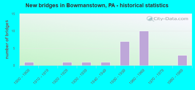
- New bridges - historical statistics
- 11900-1909
- 11920-1929
- 11930-1939
- 11940-1949
- 71950-1959
- 101960-1969
- 31980-1989
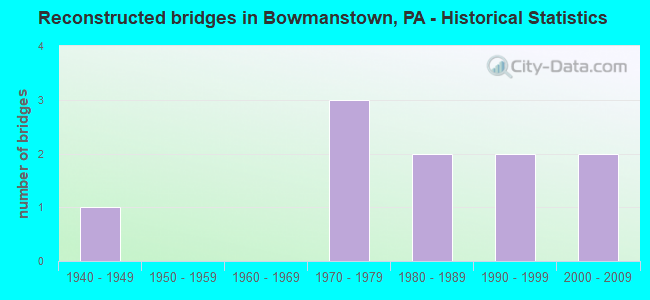
- Reconstructed bridges - Historical Statistics
- 11940-1949
- 01950-1959
- 01960-1969
- 31970-1979
- 21980-1989
- 21990-1999
- 22000-2009
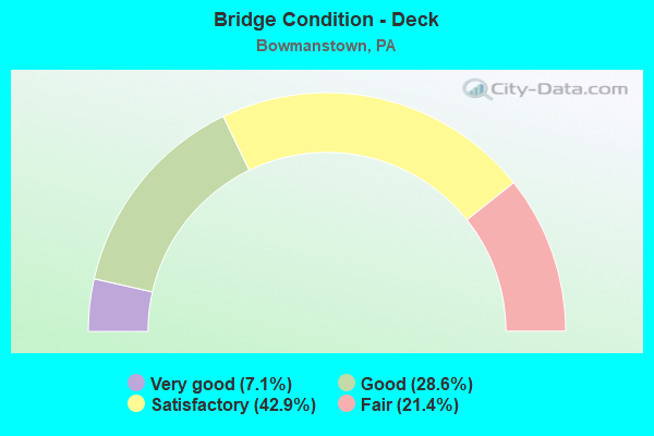
- Bridge Condition - Deck
- 7.1%Very good
- 28.6%Good
- 42.9%Satisfactory
- 21.4%Fair
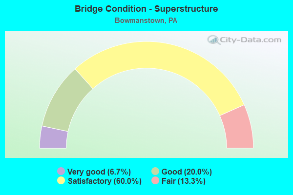
- Bridge Condition - Superstructure
- 6.7%Very good
- 20.0%Good
- 60.0%Satisfactory
- 13.3%Fair
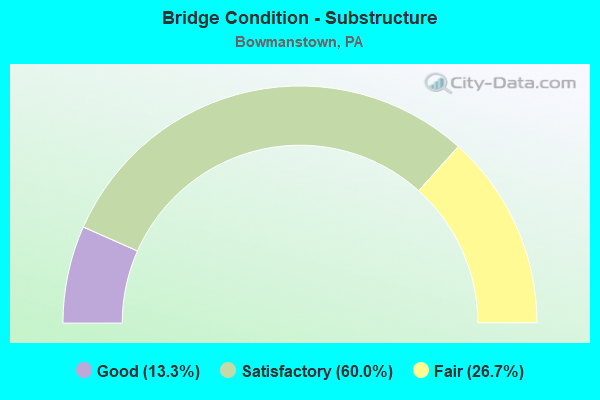
- Bridge Condition - Substructure
- 13.3%Good
- 60.0%Satisfactory
- 26.7%Fair
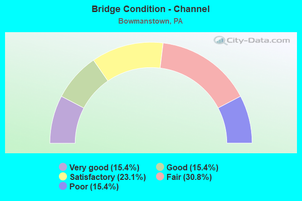
- Bridge Condition - Channel
- 15.4%Very good
- 15.4%Good
- 23.1%Satisfactory
- 30.8%Fair
- 15.4%Poor
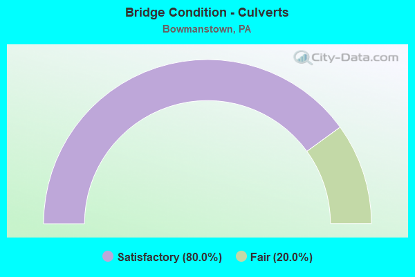
- Bridge Condition - Culverts
- 80.0%Satisfactory
- 20.0%Fair
Find on map >> Show street view
Structure Number: 675, Location: LR 1074 SB (Lat: 40.388111, Lng: -79.829456), Route carried "on" structure: US 30, Year Built: 1931, Status: Open, Structure Length: 1.22m (4.00ft), Average Daily Traffic: 19,680 (year 2022), Truck Traffic: 6%, Average Future Daily Traffic: 22,553 (year 2032), Design Load: HS 20, Features Intersected: SR 2037
Minimum Vertical Clearance: 30+ m (98+ ft), Kilometerpoint: 18.519, Lanes on structure: 4, Lanes under structure: 2, Base Highway Network: Yes, Owner: State Highway Agency, Approaching Roadway Width: 17.7m (58.1ft), Skew: 2 degrees, Material/Design: Concrete, Design/Construction: Culvert, Number Of Spans In Main Unit: 1, Length of Maximum Span: 12.2m (40.0ft)
Condition: Culverts: Fair, Operating Rating: 49.0 metric tons, Method Used To Determine Operating Rating: Field evaluation and documented engineering judgment, Inventory Rating: 32.7 metric tons, Method Used To Determine Inventory Rating: Field evaluation and documented engineering judgment, Structural Evaluation: Somewhat better than minimum adequacy, Underclear: High priority of corrective action, Approach Roadway Alignment: Equal to present desirable criteria, Length Of Structure Improvement: 1.20m (3.94ft), Designated Inspection Frequency: Every 24 months, Inspection Date: September 2021, Bridge Improvement Cost: $91,000, Roadway Improvement Cost: $267,000, Total Project Cost: $1,224,000
Find on map >> Show street view
Structure Number: 5586, Location: 1.13 MILE S. FROM EXIT 28 (Lat: 40.425825, Lng: -78.424192), Route carried "on" structure: Interstate 99, Year Built: 1981, Year Reconstructed: 2013, Status: Open, Structure Length: 10.42m (34.19ft), Average Daily Traffic: 10,207 (year 2021), Truck Traffic: 15%, Average Future Daily Traffic: 12,271 (year 2032), Design Load: HS 20, Features Intersected: US 22,BORO ST,ABANDON RR
Minimum Vertical Clearance: 30+ m (98+ ft), Kilometerpoint: 20.238, Lanes on structure: 2, Lanes under structure: 4, Base Highway Network: Yes, Owner: State Highway Agency, Approaching Roadway Width: 12.2m (40.0ft), Skew: 10 degrees, Material/Design: Prestressed concrete, Design/Construction: Stringer/Multi-beam, Number Of Spans In Main Unit: 5, Length of Maximum Span: 25.6m (84.0ft), Curb or Sidewalk Widths: Left: 0.2m (0.7ft), Right: 0.2m (0.7ft), Curb-To-Curb Width: 12.8m (42.0ft), Out-to-Out Width: 13.9m (45.6ft)
Condition: Deck: Fair, Superstructure: Satisfactory, Substructure: Satisfactory, Operating Rating: 68.0 metric tons, Method Used To Determine Operating Rating: Load Factor (LF), Inventory Rating: 33.6 metric tons, Method Used To Determine Inventory Rating: Load Factor (LF), Structural Evaluation: Equal to present minimum criteria, Deck Geometry: Equal to present desirable criteria, Underclear: Equal to present minimum criteria, Approach Roadway Alignment: Equal to present desirable criteria, Length Of Structure Improvement: 11.30m (37.07ft), Designated Inspection Frequency: Every 24 months, Inspection Date: October 2021, Deck Structure Type: Concrete Cast-file-Place, Wearing Surface/Protective System: Wearing Surface: Epoxy Overlay, Deck Protection: Epoxy Coated Reinforcing
Find on map >> Show street view
Structure Number: 5794, Location: .25 MI.S.OF DUNCANSVILLE (Lat: 40.417197, Lng: -78.438197), Route carried "on" structure: US 220B, Year Built: 1955, Year Reconstructed: 1987, Status: Open, Structure Length: 1.34m (4.40ft), Average Daily Traffic: 9,040 (year 2020), Truck Traffic: 3%, Average Future Daily Traffic: 13,381 (year 2032), Design Load: HS 20, Features Intersected: DRY RUN, Facility Carried by Structure: SR 3013
Minimum Vertical Clearance: 30+ m (98+ ft), Kilometerpoint: 17.410, Lanes on structure: 2, Owner: State Highway Agency, Approaching Roadway Width: 10.1m (33.1ft), Skew: 4 degrees, Material/Design: Concrete, Design/Construction: Tee Beam, Number Of Spans In Main Unit: 1, Length of Maximum Span: 12.2m (40.0ft), Curb or Sidewalk Widths: Left: 0.2m (0.7ft), Right: 0.2m (0.7ft), Curb-To-Curb Width: 12.2m (40.0ft), Out-to-Out Width: 13.1m (43.0ft)
Condition: Deck: Satisfactory, Superstructure: Fair, Substructure: Fair, Channel: Fair, Operating Rating: 61.7 metric tons, Method Used To Determine Operating Rating: Load Factor (LF), Inventory Rating: 37.2 metric tons, Method Used To Determine Inventory Rating: Load Factor (LF), Structural Evaluation: Somewhat better than minimum adequacy, Deck Geometry: Somewhat better than minimum adequacy, Waterway Adequacy: Equal to present minimum criteria, Approach Roadway Alignment: Equal to present desirable criteria, Length Of Structure Improvement: 1.58m (5.18ft), Designated Inspection Frequency: Every 24 months, Inspection Date: June 2020, Bridge Improvement Cost: $54,000, Roadway Improvement Cost: $264,000, Total Project Cost: $729,000, Deck Structure Type: Concrete Cast-file-Place, Wearing Surface/Protective System: Wearing Surface: Bituminous, Membrane: Preformed Fabric
Find on map >> Show street view
Structure Number: 8115, Location: LAKE ONEIDA (Lat: 40.936461, Lng: -79.846039), Route carried "on" structure: State highway , Year Built: 1968, Status: Open, Structure Length: 1.37m (4.49ft), Average Daily Traffic: 937 (year 2021), Truck Traffic: 3%, Average Future Daily Traffic: 1,196 (year 2032), Design Load: HS 20, Features Intersected: LAKE ONEIDA / CONNOQ CR, Facility Carried by Structure: SR4002
Minimum Vertical Clearance: 30+ m (98+ ft), Kilometerpoint: 11.682, Lanes on structure: 2, Owner: State Highway Agency, Approaching Roadway Width: 6.7m (22.0ft), Material/Design: Prestressed concrete, Design/Construction: Box Beam or Girders - Single/Spread, Number Of Spans In Main Unit: 1, Length of Maximum Span: 12.8m (42.0ft), Curb or Sidewalk Widths: Left: 0.2m (0.7ft), Right: 0.2m (0.7ft), Curb-To-Curb Width: 10.4m (34.1ft), Out-to-Out Width: 11.7m (38.4ft)
Condition: Deck: Satisfactory, Superstructure: Good, Substructure: Satisfactory, Channel: Fair, Operating Rating: 73.5 metric tons, Method Used To Determine Operating Rating: Load Factor (LF), Inventory Rating: 43.5 metric tons, Method Used To Determine Inventory Rating: Load Factor (LF), Structural Evaluation: Equal to present minimum criteria, Deck Geometry: Equal to present minimum criteria, Waterway Adequacy: Superior to present desirable criteria, Approach Roadway Alignment: Equal to present desirable criteria, Length Of Structure Improvement: 2.90m (9.51ft), Designated Inspection Frequency: Every 48 months, Underwater Inspection Frequency: Every 60 months, Inspection Date: January 2019, Underwater Inspection Date: April 2021, Bridge Improvement Cost: $14,000, Roadway Improvement Cost: $40,000, Total Project Cost: $184,000, Deck Structure Type: Concrete Cast-file-Place, Wearing Surface/Protective System: Wearing Surface: Monolithic Concrete, Deck Protection: Epoxy Coated Reinforcing
Find on map >> Show street view
Structure Number: 8556, Location: ECKENRODE MILL (Lat: 40.598572, Lng: -78.652669), Route carried "on" structure: State highway , Year Built: 1941, Year Reconstructed: 2011, Status: Open, Structure Length: 3.60m (11.81ft), Average Daily Traffic: 1,003 (year 2022), Truck Traffic: 10%, Average Future Daily Traffic: 949 (year 2032), Design Load: HS 20, Features Intersected: CHEST CREEK, Facility Carried by Structure: SR 1008
Minimum Vertical Clearance: 30+ m (98+ ft), Kilometerpoint: 1.431, Lanes on structure: 2, Owner: State Highway Agency, Approaching Roadway Width: 7.0m (23.0ft), Material/Design: Steel, Design/Construction: Truss - Thru, Number Of Spans In Main Unit: 1, Length of Maximum Span: 34.4m (112.9ft), Curb-To-Curb Width: 7.2m (23.6ft), Out-to-Out Width: 7.8m (25.6ft)
Condition: Deck: Very good, Superstructure: Satisfactory, Substructure: Fair, Channel: Satisfactory, Operating Rating: 59.9 metric tons, Method Used To Determine Operating Rating: Allowable Stress (AS), Inventory Rating: 37.2 metric tons, Method Used To Determine Inventory Rating: Allowable Stress (AS), Structural Evaluation: Somewhat better than minimum adequacy, Deck Geometry: High priority of corrective action, Waterway Adequacy: Better than present minimum criteria, Approach Roadway Alignment: Equal to present desirable criteria, Length Of Structure Improvement: 4.50m (14.76ft), Designated Inspection Frequency: Every 24 months, Critical Feature Inspection Frequency: Every 24 months, Inspection Date: October 2020, Critical Feature Inspection Date: October 2020, Bridge Improvement Cost: $108,000, Roadway Improvement Cost: $318,000, Total Project Cost: $1,457,000, Deck Structure Type: Concrete Cast-file-Place, Wearing Surface/Protective System: Wearing Surface: Monolithic Concrete, Membrane: Preformed Fabric, Deck Protection: Epoxy Coated Reinforcing
Find on map >> Show street view
Structure Number: 8975, Location: 1 MI.E.OF EAST SIDE BORO (Lat: 41.055828, Lng: -75.726053), Route carried "on" structure: Interstate 80, Year Built: 1965, Status: Open, Structure Length: 0.64m (2.10ft), Average Daily Traffic: 26,360 (year 2021), Truck Traffic: 61%, Average Future Daily Traffic: 25,297 (year 2032), Design Load: HS 20+Mod, Features Intersected: BLACK CREEK
Minimum Vertical Clearance: 30+ m (98+ ft), Kilometerpoint: 3.652, Lanes on structure: 4, Base Highway Network: Yes, Owner: State Highway Agency, Approaching Roadway Width: 24.4m (80.1ft), Skew: 21 degrees, Material/Design: Concrete, Design/Construction: Culvert, Number Of Spans In Main Unit: 1, Length of Maximum Span: 6.4m (21.0ft)
Condition: Channel: Poor, Culverts: Satisfactory, Operating Rating: 89.8 metric tons, Method Used To Determine Operating Rating: Load Factor (LF), Inventory Rating: 89.8 metric tons, Method Used To Determine Inventory Rating: Load Factor (LF), Structural Evaluation: Equal to present minimum criteria, Waterway Adequacy: Superior to present desirable criteria, Approach Roadway Alignment: Equal to present desirable criteria, Length Of Structure Improvement: 1.20m (3.94ft), Designated Inspection Frequency: Every 48 months, Inspection Date: October 2019
Find on map >> Show street view
Structure Number: 9006, Location: BOWMANSTOWN BORO LINE (Lat: 40.805761, Lng: -75.669564), Route carried "on" structure: State highway 248, Year Built: 1962, Year Reconstructed: 1979, Status: Open, Structure Length: 11.16m (36.61ft), Average Daily Traffic: 16,567 (year 2020), Truck Traffic: 6%, Average Future Daily Traffic: 21,433 (year 2032), Design Load: HS 20, Features Intersected: NORFOLK&SOUTHERN RR
Minimum Vertical Clearance: 30+ m (98+ ft), Kilometerpoint: 3.906, Lanes on structure: 4, Base Highway Network: Yes, Owner: State Highway Agency, Approaching Roadway Width: 21.6m (70.9ft), Skew: 36 degrees, Material/Design: Steel continuous, Design/Construction: Stringer/Multi-beam, Number Of Spans In Main Unit: 3, Length of Maximum Span: 44.8m (147.0ft), Curb-To-Curb Width: 17.1m (56.1ft), Out-to-Out Width: 20.0m (65.6ft)
Condition: Deck: Fair, Superstructure: Satisfactory, Substructure: Fair, Operating Rating: 89.8 metric tons, Method Used To Determine Operating Rating: Load Factor (LF), Inventory Rating: 57.2 metric tons, Method Used To Determine Inventory Rating: Load Factor (LF), Structural Evaluation: Somewhat better than minimum adequacy, Deck Geometry: Somewhat better than minimum adequacy, Underclear: High priority of corrective action, Approach Roadway Alignment: Better than present minimum criteria, Length Of Structure Improvement: 12.10m (39.70ft), Designated Inspection Frequency: Every 24 months, Inspection Date: October 2020, Deck Structure Type: Concrete Cast-file-Place, Wearing Surface/Protective System: Wearing Surface: Bituminous
Find on map >> Show street view
Structure Number: 9007, Location: BOWMANSTOWN BORO (Lat: 40.799306, Lng: -75.666731), Route carried "on" structure: State highway 248, Year Built: 1962, Status: Open, Structure Length: 0.85m (2.79ft), Average Daily Traffic: 17,599 (year 2022), Truck Traffic: 6%, Average Future Daily Traffic: 22,171 (year 2032), Design Load: HS 20, Features Intersected: FIRELINE CREEK
Minimum Vertical Clearance: 30+ m (98+ ft), Kilometerpoint: 3.906, Lanes on structure: 4, Base Highway Network: Yes, Owner: State Highway Agency, Approaching Roadway Width: 24.7m (81.0ft), Skew: 34 degrees, Material/Design: Concrete, Design/Construction: Culvert, Number Of Spans In Main Unit: 1, Length of Maximum Span: 8.5m (27.9ft)
Condition: Channel: Satisfactory, Culverts: Satisfactory, Operating Rating: 77.1 metric tons, Method Used To Determine Operating Rating: Load Factor (LF), Inventory Rating: 59.0 metric tons, Method Used To Determine Inventory Rating: Load Factor (LF), Structural Evaluation: Equal to present minimum criteria, Waterway Adequacy: Superior to present desirable criteria, Approach Roadway Alignment: Equal to present desirable criteria, Length Of Structure Improvement: 1.50m (4.92ft), Designated Inspection Frequency: Every 24 months, Inspection Date: June 2020
Find on map >> Show street view
Structure Number: 9031, Location: BOWMANSTOWN BORO LINE (Lat: 40.799222, Lng: -75.669483), Route carried "on" structure: State highway 895, Year Built: 1986, Status: Open, Structure Length: 13.50m (44.29ft), Average Daily Traffic: 3,600 (year 2022), Truck Traffic: 9%, Average Future Daily Traffic: 4,034 (year 2032), Design Load: HS 20, Features Intersected: LEHIGH RIVER
Minimum Vertical Clearance: 30+ m (98+ ft), Kilometerpoint: 11.188, Lanes on structure: 2, Owner: State Highway Agency, Approaching Roadway Width: 11.0m (36.1ft), Skew: 1 degrees, Material/Design: Prestressed concrete, Design/Construction: Box Beam or Girders - Single/Spread, Number Of Spans In Main Unit: 5, Length of Maximum Span: 26.5m (86.9ft), Curb or Sidewalk Widths: Left: 1.5m (4.9ft), Right: 0.2m (0.7ft), Curb-To-Curb Width: 11.0m (36.1ft), Out-to-Out Width: 13.3m (43.6ft)
Condition: Deck: Satisfactory, Superstructure: Satisfactory, Substructure: Satisfactory, Channel: Good, Operating Rating: 88.9 metric tons, Method Used To Determine Operating Rating: Load Factor (LF), Inventory Rating: 46.3 metric tons, Method Used To Determine Inventory Rating: Load Factor (LF), Structural Evaluation: Equal to present minimum criteria, Deck Geometry: Somewhat better than minimum adequacy, Waterway Adequacy: Superior to present desirable criteria, Approach Roadway Alignment: Equal to present desirable criteria, Length Of Structure Improvement: 14.40m (47.24ft), Designated Inspection Frequency: Every 24 months, Underwater Inspection Frequency: Every 60 months, Inspection Date: May 2021, Underwater Inspection Date: May 2020, Deck Structure Type: Concrete Cast-file-Place, Wearing Surface/Protective System: Wearing Surface: Epoxy Overlay, Deck Protection: Epoxy Coated Reinforcing
Find on map >> Show street view
Structure Number: 9065, Location: FIRELINE ROAD (Lat: 40.807900, Lng: -75.656864), Route carried "on" structure: State highway , Year Built: 1950, Status: Open, Structure Length: 0.70m (2.30ft), Average Daily Traffic: 1,835 (year 2022), Truck Traffic: 7%, Average Future Daily Traffic: 2,587 (year 2032), Design Load: HS 20, Features Intersected: FIRELINE CREEK, Facility Carried by Structure: SR 2004 (LR 13014)
Minimum Vertical Clearance: 30+ m (98+ ft), Kilometerpoint: 0.602, Lanes on structure: 2, Owner: State Highway Agency, Approaching Roadway Width: 10.1m (33.1ft), Skew: 4 degrees, Material/Design: Concrete, Design/Construction: Culvert, Number Of Spans In Main Unit: 1, Length of Maximum Span: 7.0m (23.0ft), Curb-To-Curb Width: 12.5m (41.0ft), Out-to-Out Width: 13.4m (44.0ft)
Condition: Channel: Poor, Culverts: Satisfactory, Operating Rating: 46.3 metric tons, Method Used To Determine Operating Rating: Load Factor (LF), Inventory Rating: 27.2 metric tons, Method Used To Determine Inventory Rating: Load Factor (LF), Structural Evaluation: Equal to present minimum criteria, Deck Geometry: Better than present minimum criteria, Waterway Adequacy: Equal to present desirable criteria, Approach Roadway Alignment: Equal to present desirable criteria, Length Of Structure Improvement: 1.30m (4.27ft), Designated Inspection Frequency: Every 24 months, Inspection Date: May 2021
Find on map >> Show street view
Structure Number: 9086, Location: BOWMANSTOWN(BANK ST.) (Lat: 40.798331, Lng: -75.664214), Route carried "on" structure: Ramp State highway , Year Built: 1962, Year Reconstructed: 1982, Status: Open, Structure Length: 1.52m (4.99ft), Average Daily Traffic: 3,927 (year 2022), Truck Traffic: 5%, Average Future Daily Traffic: 5,545 (year 2032), Design Load: HS 20, Features Intersected: NORFOLK/SOUTHERN RR, Facility Carried by Structure: SR 2019(LR 163 RP)
Minimum Vertical Clearance: 30+ m (98+ ft), Kilometerpoint: 0.000, Lanes on structure: 2, Owner: State Highway Agency, Approaching Roadway Width: 11.0m (36.1ft), Skew: 1 degrees, Material/Design: Steel, Design/Construction: Stringer/Multi-beam, Number Of Spans In Main Unit: 1, Length of Maximum Span: 13.4m (44.0ft), Curb or Sidewalk Widths: Left: 0.2m (0.7ft), Right: 1.5m (4.9ft), Curb-To-Curb Width: 10.7m (35.1ft), Out-to-Out Width: 13.1m (43.0ft)
Condition: Deck: Satisfactory, Superstructure: Good, Substructure: Satisfactory, Operating Rating: 52.6 metric tons, Method Used To Determine Operating Rating: Load Factor (LF), Inventory Rating: 31.8 metric tons, Method Used To Determine Inventory Rating: Load Factor (LF), Structural Evaluation: Equal to present minimum criteria, Deck Geometry: Better than present minimum criteria, Underclear: High priority of corrective action, Approach Roadway Alignment: Better than present minimum criteria, Length Of Structure Improvement: 2.20m (7.22ft), Designated Inspection Frequency: Every 24 months, Inspection Date: March 2020, Deck Structure Type: Concrete Cast-file-Place, Wearing Surface/Protective System: Wearing Surface: Latex Concrete
Find on map >> Show street view
Structure Number: 9087, Location: BOWMANSTOWN(BANK ST.) (Lat: 40.798103, Lng: -75.664869), Route carried "on" structure: Ramp State highway , Year Built: 1962, Year Reconstructed: 1982, Status: Open, Structure Length: 2.87m (9.42ft), Average Daily Traffic: 3,927 (year 2022), Truck Traffic: 5%, Average Future Daily Traffic: 5,545 (year 2032), Design Load: HS 20, Features Intersected: PA248 (LR 163), Facility Carried by Structure: SR 2019(LR 163 RP)
Minimum Vertical Clearance: 30+ m (98+ ft), Kilometerpoint: 0.000, Lanes on structure: 2, Lanes under structure: 8, Owner: State Highway Agency, Approaching Roadway Width: 11.0m (36.1ft), Skew: 3 degrees, Material/Design: Prestressed concrete, Design/Construction: Stringer/Multi-beam, Number Of Spans In Main Unit: 1, Length of Maximum Span: 26.5m (86.9ft), Curb or Sidewalk Widths: Left: 0.2m (0.7ft), Right: 1.5m (4.9ft), Curb-To-Curb Width: 10.7m (35.1ft), Out-to-Out Width: 13.1m (43.0ft)
Condition: Deck: Fair, Superstructure: Satisfactory, Substructure: Satisfactory, Operating Rating: 49.9 metric tons, Method Used To Determine Operating Rating: Load Factor (LF), Inventory Rating: 29.0 metric tons, Method Used To Determine Inventory Rating: Load Factor (LF), Structural Evaluation: Equal to present minimum criteria, Deck Geometry: Better than present minimum criteria, Underclear: Meets minimum limits, Approach Roadway Alignment: Better than present minimum criteria, Length Of Structure Improvement: 3.60m (11.81ft), Designated Inspection Frequency: Every 24 months, Inspection Date: Febuary 2020, Deck Structure Type: Concrete Cast-file-Place, Wearing Surface/Protective System: Wearing Surface: Latex Concrete
Find on map >> Show street view
Structure Number: 9088, Location: BOWMANSTOWN(BANK ST.) (Lat: 40.798033, Lng: -75.666175), Route carried "on" structure: Ramp State highway , Year Built: 1962, Status: Open, Structure Length: 0.64m (2.10ft), Average Daily Traffic: 3,927 (year 2022), Truck Traffic: 5%, Average Future Daily Traffic: 5,545 (year 2032), Design Load: HS 20, Features Intersected: TRIB.TO LEHIGH RIVER, Facility Carried by Structure: SR 2019(LR 163 RP)
Minimum Vertical Clearance: 30+ m (98+ ft), Kilometerpoint: 0.000, Lanes on structure: 2, Owner: State Highway Agency, Approaching Roadway Width: 11.9m (39.0ft), Material/Design: Concrete, Design/Construction: Culvert, Number Of Spans In Main Unit: 1, Length of Maximum Span: 6.4m (21.0ft), Curb-To-Curb Width: 11.9m (39.0ft), Out-to-Out Width: 11.9m (39.0ft)
Condition: Channel: Fair, Culverts: Satisfactory, Inventory Rating: 90.7 metric tons, Method Used To Determine Inventory Rating: Allowable Stress (AS), Structural Evaluation: Equal to present minimum criteria, Deck Geometry: Superior to present desirable criteria, Waterway Adequacy: Superior to present desirable criteria, Approach Roadway Alignment: Equal to present desirable criteria, Length Of Structure Improvement: 1.20m (3.94ft), Designated Inspection Frequency: Every 24 months, Inspection Date: March 2020
Find on map >> Show street view
Structure Number: 9144, Location: 1.5 MI S OF BOWMANSTOWN (Lat: 40.788333, Lng: -75.666667), Route carried "on" structure: Interstate 476, Year Built: 1957, Status: Open, Structure Length: 1.31m (4.30ft), Average Daily Traffic: 27,609 (year 2001), Truck Traffic: 18%, Average Future Daily Traffic: 37,217 (year 2030), Design Load: HS 20, Features Intersected: T-337
Minimum Vertical Clearance: 30+ m (98+ ft), Kilometerpoint: 0.000, Lanes on structure: 4, Lanes under structure: 2, Base Highway Network: Yes, Toll: On toll road, Owner: State Toll Authority, Approaching Roadway Width: 25.0m (82.0ft), Skew: 34 degrees, Material/Design: Concrete, Design/Construction: Tee Beam, Number Of Spans In Main Unit: 1, Length of Maximum Span: 12.2m (40.0ft), Curb or Sidewalk Widths: Left: 0.1m (0.3ft), Right: 0.1m (0.3ft), Curb-To-Curb Width: 21.9m (71.9ft), Out-to-Out Width: 24.7m (81.0ft)
Condition: Deck: Good, Superstructure: Good, Substructure: Satisfactory, Operating Rating: 64.4 metric tons, Method Used To Determine Operating Rating: Load Factor (LF), Inventory Rating: 38.1 metric tons, Method Used To Determine Inventory Rating: Load Factor (LF), Structural Evaluation: Equal to present minimum criteria, Deck Geometry: Better than present minimum criteria, Underclear: High priority of corrective action, Approach Roadway Alignment: Equal to present desirable criteria, Length Of Structure Improvement: 2.20m (7.22ft), Designated Inspection Frequency: Every 24 months, Inspection Date: June 2021, Roadway Improvement Cost: $3,000, Total Project Cost: $3,000, Deck Structure Type: Concrete Cast-file-Place, Wearing Surface/Protective System: Wearing Surface: Latex Concrete
Find on map >> Show street view
Structure Number: 9146, Location: 0.5 MI S OF BOWMANSTOWN (Lat: 40.793169, Lng: -75.670586), Route carried "on" structure: Interstate 476, Year Built: 1957, Status: Open, Structure Length: 12.59m (41.31ft), Average Daily Traffic: 27,609 (year 2001), Truck Traffic: 18%, Average Future Daily Traffic: 37,217 (year 2030), Design Load: HS 20, Features Intersected: LIZARD CREEK
Minimum Vertical Clearance: 30+ m (98+ ft), Kilometerpoint: 0.000, Lanes on structure: 4, Base Highway Network: Yes, Toll: On toll road, Owner: State Toll Authority, Approaching Roadway Width: 21.9m (71.9ft), Skew: 31 degrees, Material/Design: Steel, Design/Construction: Stringer/Multi-beam, Number Of Spans In Main Unit: 5, Length of Maximum Span: 25.6m (84.0ft), Curb or Sidewalk Widths: Left: 0.5m (1.6ft), Right: 0.5m (1.6ft), Curb-To-Curb Width: 16.1m (52.8ft), Out-to-Out Width: 19.1m (62.7ft)
Condition: Deck: Satisfactory, Superstructure: Fair, Substructure: Fair, Channel: Very good, Operating Rating: 67.1 metric tons, Method Used To Determine Operating Rating: Load Factor (LF), Inventory Rating: 39.9 metric tons, Method Used To Determine Inventory Rating: Load Factor (LF), Structural Evaluation: Somewhat better than minimum adequacy, Deck Geometry: Meets minimum limits, Waterway Adequacy: Superior to present desirable criteria, Approach Roadway Alignment: Equal to present desirable criteria, Length Of Structure Improvement: 13.50m (44.29ft), Designated Inspection Frequency: Every 24 months, Inspection Date: August 2019, Bridge Improvement Cost: $61,000, Roadway Improvement Cost: $180,000, Total Project Cost: $825,000, Deck Structure Type: Concrete Cast-file-Place, Wearing Surface/Protective System: Wearing Surface: Latex Concrete
Find on map >> Show street view
Structure Number: 9147, Location: BOWMANSTOWN (Lat: 40.797167, Lng: -75.673600), Route carried "on" structure: State highway 895, Year Built: 1957, Year Reconstructed: 1993, Status: Open, Structure Length: 3.02m (9.91ft), Average Daily Traffic: 3,600 (year 2022), Truck Traffic: 9%, Average Future Daily Traffic: 3,938 (year 2030), Design Load: HS 20, Features Intersected: PA TPK (I-476)
Minimum Vertical Clearance: 30+ m (98+ ft), Kilometerpoint: 10.070, Lanes on structure: 2, Lanes under structure: 4, Owner: State Toll Authority, Approaching Roadway Width: 9.4m (30.8ft), Skew: 3 degrees, Material/Design: Steel, Design/Construction: Stringer/Multi-beam, Number Of Spans In Main Unit: 1, Length of Maximum Span: 28.3m (92.8ft), Curb or Sidewalk Widths: Left: 0.2m (0.7ft), Right: 0.2m (0.7ft), Curb-To-Curb Width: 14.2m (46.6ft), Out-to-Out Width: 15.3m (50.2ft)
Condition: Deck: Good, Superstructure: Satisfactory, Substructure: Satisfactory, Operating Rating: 73.5 metric tons, Method Used To Determine Operating Rating: Load Factor (LF), Inventory Rating: 43.5 metric tons, Method Used To Determine Inventory Rating: Load Factor (LF), Structural Evaluation: Equal to present minimum criteria, Deck Geometry: Superior to present desirable criteria, Underclear: High priority of corrective action, Approach Roadway Alignment: Equal to present desirable criteria, Length Of Structure Improvement: 3.70m (12.14ft), Designated Inspection Frequency: Every 24 months, Inspection Date: June 2021, Bridge Improvement Cost: $44,000, Roadway Improvement Cost: $128,000, Total Project Cost: $588,000, Deck Structure Type: Concrete Cast-file-Place, Wearing Surface/Protective System: Wearing Surface: Latex Concrete
Find on map >> Show street view
Structure Number: 9286, Location: CLFD & CENTRE CNTY LINE (Lat: 40.967783, Lng: -78.084522), Route carried "on" structure: Interstate 80, Year Built: 1968, Year Reconstructed: 2003, Status: Open, Structure Length: 37.25m (122.21ft), Average Daily Traffic: 10,340 (year 2021), Truck Traffic: 88%, Average Future Daily Traffic: 12,999 (year 2041), Design Load: HS 25 or greater, Features Intersected: MOSHANNON CREEK
Minimum Vertical Clearance: 30+ m (98+ ft), Kilometerpoint: 0.000, Lanes on structure: 2, Base Highway Network: Yes, Owner: State Highway Agency, Approaching Roadway Width: 12.2m (40.0ft), Skew: 10 degrees, Material/Design: Steel continuous, Design/Construction: Stringer/Multi-beam, Number Of Spans In Main Unit: 7, Length of Maximum Span: 56.1m (184.1ft), Curb or Sidewalk Widths: Left: 0.1m (0.3ft), Right: 0.1m (0.3ft), Curb-To-Curb Width: 12.8m (42.0ft), Out-to-Out Width: 13.7m (44.9ft)
Condition: Deck: Good, Superstructure: Very good, Substructure: Good, Channel: Very good, Operating Rating: 81.6 metric tons, Method Used To Determine Operating Rating: Load Factor (LF), Inventory Rating: 49.0 metric tons, Method Used To Determine Inventory Rating: Load Factor (LF), Structural Evaluation: Better than present minimum criteria, Deck Geometry: Equal to present desirable criteria, Waterway Adequacy: Superior to present desirable criteria, Approach Roadway Alignment: Equal to present desirable criteria, Length Of Structure Improvement: 37.50m (123.03ft), Designated Inspection Frequency: Every 24 months, Inspection Date: May 2021, Bridge Improvement Cost: $883,000, Roadway Improvement Cost: $2,602,000, Total Project Cost: $11,925,000, Deck Structure Type: Concrete Cast-file-Place, Wearing Surface/Protective System: Wearing Surface: Monolithic Concrete, Deck Protection: Epoxy Coated Reinforcing
Find on map >> Show street view
Structure Number: 9424, Location: HANNAH (Lat: 40.756914, Lng: -78.113150), Route carried "on" structure: US 220B, Year Built: 1925, Year Reconstructed: 1952, Status: Open, Structure Length: 1.25m (4.10ft), Average Daily Traffic: 1,286 (year 2021), Truck Traffic: 8%, Average Future Daily Traffic: 2,036 (year 2040), Design Load: H 15, Features Intersected: VAUGHNS RUN, Facility Carried by Structure: SR 220-US 220
Minimum Vertical Clearance: 30+ m (98+ ft), Kilometerpoint: 1.717, Lanes on structure: 2, Owner: State Highway Agency, Approaching Roadway Width: 9.4m (30.8ft), Material/Design: Concrete, Design/Construction: Slab, Number Of Spans In Main Unit: 2, Length of Maximum Span: 6.1m (20.0ft), Curb-To-Curb Width: 11.3m (37.1ft), Out-to-Out Width: 12.6m (41.3ft)
Condition: Deck: Satisfactory, Superstructure: Satisfactory, Substructure: Satisfactory, Channel: Fair, Operating Rating: 48.1 metric tons, Method Used To Determine Operating Rating: Load Factor (LF), Inventory Rating: 29.9 metric tons, Method Used To Determine Inventory Rating: Load Factor (LF), Structural Evaluation: Equal to present minimum criteria, Deck Geometry: Equal to present minimum criteria, Waterway Adequacy: Equal to present minimum criteria, Approach Roadway Alignment: Equal to present desirable criteria, Length Of Structure Improvement: 1.20m (3.94ft), Designated Inspection Frequency: Every 24 months, Inspection Date: May 2020, Bridge Improvement Cost: $38,000, Roadway Improvement Cost: $250,000, Total Project Cost: $511,000, Deck Structure Type: Concrete Cast-file-Place, Wearing Surface/Protective System: Wearing Surface: Bituminous
Find on map >> Show street view
Structure Number: 9504, Location: 3 MI N STATE COLLEGE (Lat: 40.817825, Lng: -77.833842), Route carried "on" structure: US 322, Year Built: 1984, Status: Open, Structure Length: 5.06m (16.60ft), Average Daily Traffic: 5,041 (year 2020), Truck Traffic: 16%, Average Future Daily Traffic: 15,973 (year 2041), Design Load: HS 20, Features Intersected: SR 3012, SLAB CABIN RUN
Minimum Vertical Clearance: 30+ m (98+ ft), Kilometerpoint: 21.828, Lanes on structure: 3, Lanes under structure: 2, Base Highway Network: Yes, Owner: State Highway Agency, Approaching Roadway Width: 15.2m (49.9ft), Skew: 2 degrees, Material/Design: Prestressed concrete, Design/Construction: Box Beam or Girders - Single/Spread, Number Of Spans In Main Unit: 3, Length of Maximum Span: 22.9m (75.1ft), Curb or Sidewalk Widths: Left: 0.2m (0.7ft), Right: 0.2m (0.7ft), Curb-To-Curb Width: 17.0m (55.8ft), Out-to-Out Width: 18.1m (59.4ft)
Condition: Deck: Good, Superstructure: Satisfactory, Substructure: Good, Channel: Good, Operating Rating: 47.2 metric tons, Method Used To Determine Operating Rating: Load Factor (LF), Inventory Rating: 28.1 metric tons, Method Used To Determine Inventory Rating: Load Factor (LF), Structural Evaluation: Equal to present minimum criteria, Deck Geometry: Equal to present minimum criteria, Underclear: Meets minimum limits, Waterway Adequacy: Superior to present desirable criteria, Approach Roadway Alignment: Equal to present desirable criteria, Length Of Structure Improvement: 5.10m (16.73ft), Designated Inspection Frequency: Every 24 months, Inspection Date: July 2021, Deck Structure Type: Concrete Cast-file-Place, Wearing Surface/Protective System: Wearing Surface: Monolithic Concrete, Deck Protection: Epoxy Coated Reinforcing
Find on map >> Show street view
Structure Number: 40954, Location: 0.4 MI S OF W.BOWMANSTOWN (Lat: 40.795297, Lng: -75.664781), Route carried "on" structure: City street , Year Built: 1904, Year Reconstructed: 1999, Status: Open, Structure Length: 2.90m (9.51ft), Average Daily Traffic: 350 (year 2000), Truck Traffic: 6%, Average Future Daily Traffic: 700 (year 2030), Features Intersected: LIZARD CREEK, Facility Carried by Structure: RIVERVIEW RD
Minimum Vertical Clearance: 30+ m (98+ ft), Kilometerpoint: 0.000, Lanes on structure: 2, Owner: County Highway Agency, Approaching Roadway Width: 9.1m (29.9ft), Skew: 2 degrees, Material/Design: Concrete, Design/Construction: Arch - Deck, Number Of Spans In Main Unit: 3, Length of Maximum Span: 6.7m (22.0ft), Curb or Sidewalk Widths: Left: 0.2m (0.7ft), Right: 0.2m (0.7ft), Curb-To-Curb Width: 9.1m (29.9ft), Out-to-Out Width: 10.0m (32.8ft)
Condition: Superstructure: Satisfactory, Substructure: Satisfactory, Channel: Satisfactory, Operating Rating: 49.0 metric tons, Method Used To Determine Operating Rating: Field evaluation and documented engineering judgment, Inventory Rating: 32.7 metric tons, Method Used To Determine Inventory Rating: Field evaluation and documented engineering judgment, Structural Evaluation: Equal to present minimum criteria, Deck Geometry: Equal to present minimum criteria, Waterway Adequacy: Superior to present desirable criteria, Approach Roadway Alignment: Equal to present desirable criteria, Designated Inspection Frequency: Every 24 months, Inspection Date: March 2021
Find on map >> Show street view
Structure Number: 9087, Location: BOWMANSTOWN(BANK ST.) (Lat: 40.798103, Lng: -75.664869), Route carried "under" structure: State highway 248, Year Built: 1962, Structure Length: 0. m, Average Daily Traffic: 9,370 (year 2022), Truck Traffic: 6%, Features Intersected: PA248 (LR 163), Facility Carried by Structure: SR 2019(LR 163 RP)
Minimum Vertical Clearance: 5.54m (18.18ft), Kilometerpoint: 4.892, Lanes on structure: 2, Lanes under structure: 4, Material/Design: Prestressed concrete, Design/Construction: Stringer/Multi-beam, Length of Maximum Span: 26.5m (86.9ft)
Find on map >> Show street view
Structure Number: 9087, Location: BOWMANSTOWN(BANK ST.) (Lat: 40.798103, Lng: -75.664869), Route carried "under" structure: State highway 248, Year Built: 1962, Structure Length: 0. m, Average Daily Traffic: 8,229 (year 2020), Truck Traffic: 6%, Features Intersected: PA248 (LR 163), Facility Carried by Structure: SR 2019(LR 163 RP)
Minimum Vertical Clearance: 6.16m (20.21ft), Kilometerpoint: 4.905, Lanes on structure: 2, Lanes under structure: 4, Material/Design: Prestressed concrete, Design/Construction: Stringer/Multi-beam, Length of Maximum Span: 26.5m (86.9ft)
Find on map >> Show street view
Structure Number: 9144, Location: 1.5 MI S OF BOWMANSTOWN (Lat: 40.788333, Lng: -75.666667), Route carried "under" structure: City street , Year Built: 1957, Structure Length: 0. m, Average Daily Traffic: 200 (year 1992), Features Intersected: T-337, Facility Carried by Structure: PA TPK (I-476)
Minimum Vertical Clearance: 4.19m (13.75ft), Kilometerpoint: 0.000, Lanes on structure: 4, Lanes under structure: 2, Toll: On toll road, Material/Design: Concrete, Design/Construction: Tee Beam, Length of Maximum Span: 12.2m (40.0ft)
Find on map >> Show street view
Structure Number: 9147, Location: BOWMANSTOWN (Lat: 40.797167, Lng: -75.673600), Route carried "under" structure: Interstate 476, Year Built: 1957, Structure Length: 0. m, Average Daily Traffic: 30,563 (year 2004), Truck Traffic: 18%, Features Intersected: PA TPK (I-476), Facility Carried by Structure: SR0895, LR13001
Minimum Vertical Clearance: 4.55m (14.93ft), Kilometerpoint: 0.000, Lanes on structure: 2, Lanes under structure: 4, Material/Design: Steel, Design/Construction: Stringer/Multi-beam, Length of Maximum Span: 28.3m (92.8ft)