Bridge Statistics for Bradley Gardens, New Jersey (NJ)
Condition, Traffic, Stress, Structural Evaluation, Project Costs
- National Bridge Inventory (NBI) Statistics
- 35Number of bridges
- 367ft / 112mTotal length
- $36,067,000Total costs
- 319,803Total average daily traffic
- 12,090Total average daily truck traffic
- National Bridge Inventory (NBI) Registered Bridges for Bradley Gardens
- No street view available for this location
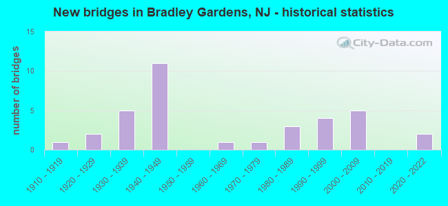
- New bridges - historical statistics
- 11910-1919
- 21920-1929
- 51930-1939
- 111940-1949
- 11960-1969
- 11970-1979
- 31980-1989
- 41990-1999
- 52000-2009
- 22020-2022
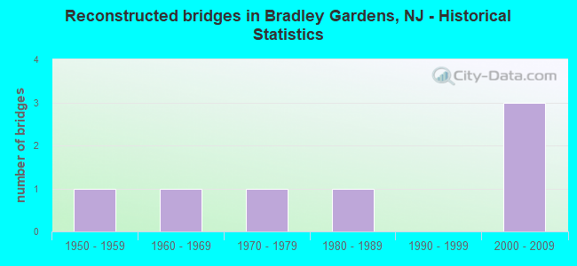
- Reconstructed bridges - Historical Statistics
- 11950-1959
- 11960-1969
- 11970-1979
- 11980-1989
- 01990-1999
- 32000-2009
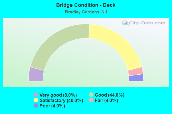
- Bridge Condition - Deck
- 8.0%Very good
- 44.0%Good
- 40.0%Satisfactory
- 4.0%Fair
- 4.0%Poor
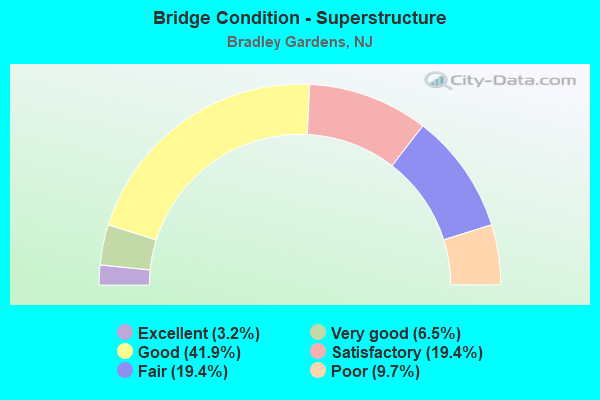
- Bridge Condition - Superstructure
- 3.2%Excellent
- 6.5%Very good
- 41.9%Good
- 19.4%Satisfactory
- 19.4%Fair
- 9.7%Poor
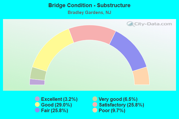
- Bridge Condition - Substructure
- 3.2%Excellent
- 6.5%Very good
- 29.0%Good
- 25.8%Satisfactory
- 25.8%Fair
- 9.7%Poor
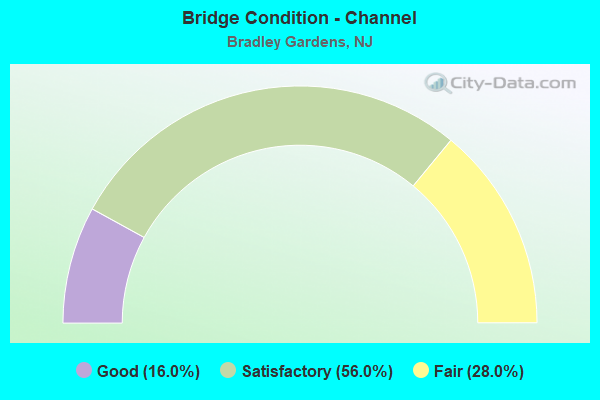
- Bridge Condition - Channel
- 16.0%Good
- 56.0%Satisfactory
- 28.0%Fair
Find on map >> Show street view
Structure Number: 180115, Location: 1 MI WEST OF RT 28 JCT (Lat: 40.598331, Lng: -74.678331), Route carried "on" structure: US 22, Year Built: 1942, Year Reconstructed: 2008, Status: Open, Structure Length: 1.77m (5.81ft), Average Daily Traffic: 23,770 (year 2020), Truck Traffic: 4%, Average Future Daily Traffic: 28,420 (year 2040), Design Load: HL 93, Features Intersected: STATION ROAD (CR.679)
Minimum Vertical Clearance: 30+ m (98+ ft), Kilometerpoint: 49.359, Lanes on structure: 2, Lanes under structure: 2, Owner: State Highway Agency, Approaching Roadway Width: 12.8m (42.0ft), Skew: 1 degrees, Material/Design: Prestressed concrete, Design/Construction: Box Beam or Girders - Single/Spread, Number Of Spans In Main Unit: 1, Length of Maximum Span: 17.1m (56.1ft), Curb-To-Curb Width: 12.8m (42.0ft), Out-to-Out Width: 13.8m (45.3ft)
Condition: Deck: Good, Superstructure: Very good, Substructure: Satisfactory, Operating Rating: 61.2 metric tons, Method Used To Determine Operating Rating: Load and Resistance Factor Rating (LRFR) rating reported by rating factor(RF) method using HL-93 loadings, Inventory Rating: 43.4 metric tons, Method Used To Determine Inventory Rating: Load and Resistance Factor Rating (LRFR) rating reported by rating factor(RF) method using HL-93 loadings, Structural Evaluation: Equal to present minimum criteria, Deck Geometry: Equal to present desirable criteria, Underclear: Equal to present minimum criteria, Approach Roadway Alignment: Equal to present desirable criteria, Designated Inspection Frequency: Every 24 months, Inspection Date: April 2020, Deck Structure Type: Concrete Cast-file-Place, Wearing Surface/Protective System: Wearing Surface: Latex Concrete, Deck Protection: Epoxy Coated Reinforcing
Find on map >> Show street view
Structure Number: 1801151, Location: 1MI WEST OF RT 28 JCT (Lat: 40.598331, Lng: -74.678331), Route carried "on" structure: US 22, Year Built: 1941, Year Reconstructed: 2008, Status: Open, Structure Length: 1.77m (5.81ft), Average Daily Traffic: 19,685 (year 2020), Truck Traffic: 4%, Average Future Daily Traffic: 23,535 (year 2040), Design Load: HL 93, Features Intersected: STATION ROAD (CO.679)
Minimum Vertical Clearance: 30+ m (98+ ft), Kilometerpoint: 49.359, Lanes on structure: 2, Lanes under structure: 2, Owner: State Highway Agency, Approaching Roadway Width: 12.8m (42.0ft), Skew: 1 degrees, Material/Design: Prestressed concrete, Design/Construction: Box Beam or Girders - Multiple, Number Of Spans In Main Unit: 1, Length of Maximum Span: 17.1m (56.1ft), Curb-To-Curb Width: 12.8m (42.0ft), Out-to-Out Width: 13.8m (45.3ft)
Condition: Deck: Good, Superstructure: Good, Substructure: Satisfactory, Operating Rating: 61.2 metric tons, Method Used To Determine Operating Rating: Load and Resistance Factor Rating (LRFR) rating reported by rating factor(RF) method using HL-93 loadings, Inventory Rating: 43.4 metric tons, Method Used To Determine Inventory Rating: Load and Resistance Factor Rating (LRFR) rating reported by rating factor(RF) method using HL-93 loadings, Structural Evaluation: Equal to present minimum criteria, Deck Geometry: Equal to present desirable criteria, Underclear: Meets minimum limits, Approach Roadway Alignment: Equal to present desirable criteria, Designated Inspection Frequency: Every 24 months, Inspection Date: April 2020, Deck Structure Type: Concrete Cast-file-Place, Wearing Surface/Protective System: Wearing Surface: Latex Concrete
Find on map >> Show street view
Structure Number: 1801153, Location: .75 MI WEST OF NJ 28 (Lat: 40.597089, Lng: -74.676369), Route carried "on" structure: US 22, Year Built: 1942, Status: Open, Structure Length: 6.07m (19.91ft), Average Daily Traffic: 16,800 (year 2020), Truck Traffic: 4%, Average Future Daily Traffic: 20,200 (year 2040), Features Intersected: N BR OF RARITAN RIVER
Minimum Vertical Clearance: 30+ m (98+ ft), Kilometerpoint: 49.632, Lanes on structure: 2, Owner: State Highway Agency, Approaching Roadway Width: 10.7m (35.1ft), Skew: 1 degrees, Material/Design: Concrete, Design/Construction: Arch - Deck, Number Of Spans In Main Unit: 3, Length of Maximum Span: 20.1m (65.9ft), Curb or Sidewalk Widths: Left: 0.0m, Right: 1.2m (3.9ft), Curb-To-Curb Width: 10.7m (35.1ft), Out-to-Out Width: 13.6m (44.6ft)
Condition: Superstructure: Satisfactory, Substructure: Satisfactory, Channel: Fair, Structural Evaluation: Equal to present minimum criteria, Deck Geometry: Somewhat better than minimum adequacy, Waterway Adequacy: Equal to present desirable criteria, Approach Roadway Alignment: Equal to present desirable criteria, Length Of Structure Improvement: 6.07m (19.91ft), Designated Inspection Frequency: Every 24 months, Underwater Inspection Frequency: Every 24 months, Inspection Date: June 2020, Underwater Inspection Date: June 2020, Total Project Cost: $576,000 ( Estimate for 2020)
Find on map >> Show street view
Structure Number: 1801154, Location: 0.73 MI W OF NJ 28 (Lat: 40.597231, Lng: -74.675631), Route carried "on" structure: US 22, Year Built: 1942, Status: Open, Structure Length: 6.07m (19.91ft), Average Daily Traffic: 16,900 (year 2021), Truck Traffic: 4%, Average Future Daily Traffic: 20,300 (year 2041), Features Intersected: N BR. RARITAN RIVER
Minimum Vertical Clearance: 30+ m (98+ ft), Kilometerpoint: 49.632, Lanes on structure: 2, Base Highway Network: Yes, Owner: State Highway Agency, Approaching Roadway Width: 10.7m (35.1ft), Skew: 1 degrees, Material/Design: Concrete, Design/Construction: Arch - Deck, Number Of Spans In Main Unit: 3, Length of Maximum Span: 20.1m (65.9ft), Curb or Sidewalk Widths: Left: 2.1m (6.9ft), Right: 0.4m (1.3ft), Curb-To-Curb Width: 10.7m (35.1ft), Out-to-Out Width: 13.6m (44.6ft)
Condition: Superstructure: Satisfactory, Substructure: Fair, Channel: Fair, Structural Evaluation: Somewhat better than minimum adequacy, Deck Geometry: Somewhat better than minimum adequacy, Waterway Adequacy: Superior to present desirable criteria, Approach Roadway Alignment: Equal to present desirable criteria, Length Of Structure Improvement: 6.07m (19.91ft), Designated Inspection Frequency: Every 24 months, Underwater Inspection Frequency: Every 24 months, Inspection Date: October 2021, Underwater Inspection Date: September 2021, Total Project Cost: $845,000 ( Estimate for 2021)
Find on map >> Show street view
Structure Number: 1801156, Location: 2.5MI WEST OF US 202&206 (Lat: 40.593831, Lng: -74.662461), Route carried "on" structure: US 22, Year Built: 1949, Status: Open, Structure Length: 4.39m (14.40ft), Average Daily Traffic: 22,950 (year 2020), Truck Traffic: 4%, Average Future Daily Traffic: 28,003 (year 2040), Design Load: HS 20+Mod, Features Intersected: NJ 28
Minimum Vertical Clearance: 30+ m (98+ ft), Kilometerpoint: 50.839, Lanes on structure: 2, Lanes under structure: 2, Owner: State Highway Agency, Approaching Roadway Width: 10.7m (35.1ft), Skew: 6 degrees, Material/Design: Steel, Design/Construction: Stringer/Multi-beam, Number Of Spans In Main Unit: 2, Length of Maximum Span: 20.7m (67.9ft), Curb or Sidewalk Widths: Left: 0.5m (1.6ft), Right: 1.4m (4.6ft), Curb-To-Curb Width: 10.7m (35.1ft), Out-to-Out Width: 14.0m (45.9ft)
Condition: Deck: Satisfactory, Superstructure: Fair, Substructure: Satisfactory, Operating Rating: 81.6 metric tons, Method Used To Determine Operating Rating: Load Factor (LF), Inventory Rating: 49.0 metric tons, Method Used To Determine Inventory Rating: Load Factor (LF), Structural Evaluation: Somewhat better than minimum adequacy, Deck Geometry: Somewhat better than minimum adequacy, Underclear: Equal to present minimum criteria, Approach Roadway Alignment: Equal to present desirable criteria, Designated Inspection Frequency: Every 24 months, Inspection Date: June 2020, Deck Structure Type: Concrete Cast-file-Place, Wearing Surface/Protective System: Wearing Surface: Latex Concrete
Find on map >> Show street view
Structure Number: 1801157, Location: 2.3 MI.W.OF 22-206-202 JT (Lat: 40.594111, Lng: -74.662989), Route carried "on" structure: US 22, Year Built: 1949, Status: Open, Structure Length: 4.39m (14.40ft), Average Daily Traffic: 16,920 (year 2021), Truck Traffic: 4%, Average Future Daily Traffic: 20,300 (year 2041), Design Load: HS 20, Features Intersected: NJ 28
Minimum Vertical Clearance: 30+ m (98+ ft), Kilometerpoint: 50.839, Lanes on structure: 2, Lanes under structure: 2, Base Highway Network: Yes, Owner: State Highway Agency, Approaching Roadway Width: 10.7m (35.1ft), Skew: 6 degrees, Material/Design: Steel, Design/Construction: Stringer/Multi-beam, Number Of Spans In Main Unit: 2, Length of Maximum Span: 20.7m (67.9ft), Curb or Sidewalk Widths: Left: 1.9m (6.2ft), Right: 0.8m (2.6ft), Curb-To-Curb Width: 10.7m (35.1ft), Out-to-Out Width: 13.8m (45.3ft)
Condition: Deck: Satisfactory, Superstructure: Fair, Substructure: Satisfactory, Operating Rating: 52.6 metric tons, Method Used To Determine Operating Rating: Load Factor (LF), Inventory Rating: 31.8 metric tons, Method Used To Determine Inventory Rating: Load Factor (LF), Structural Evaluation: Somewhat better than minimum adequacy, Deck Geometry: Somewhat better than minimum adequacy, Underclear: Equal to present minimum criteria, Approach Roadway Alignment: Equal to present minimum criteria, Designated Inspection Frequency: Every 24 months, Inspection Date: September 2021, Deck Structure Type: Concrete Cast-file-Place, Wearing Surface/Protective System: Wearing Surface: Latex Concrete
Find on map >> Show street view
Structure Number: 1807155, Location: 2.7 MI S OF 202-206 CIRCL (Lat: 40.569650, Lng: -74.678450), Route carried "on" structure: US 202, Year Built: 1934, Year Reconstructed: 1959, Status: Open, Structure Length: 6.07m (19.91ft), Average Daily Traffic: 60,550 (year 2021), Truck Traffic: 4%, Average Future Daily Traffic: 726,660 (year 2041), Features Intersected: NO.BR.RARITAN RIVER
Minimum Vertical Clearance: 30+ m (98+ ft), Kilometerpoint: 35.003, Lanes on structure: 4, Base Highway Network: Yes, Owner: State Highway Agency, Approaching Roadway Width: 26.5m (86.9ft), Skew: 30 degrees, Material/Design: Concrete, Design/Construction: Arch - Deck, Number Of Spans In Main Unit: 3, Length of Maximum Span: 19.5m (64.0ft), Curb or Sidewalk Widths: Left: 1.5m (4.9ft), Right: 1.5m (4.9ft), Curb-To-Curb Width: 23.6m (77.4ft), Out-to-Out Width: 30.4m (99.7ft)
Condition: Superstructure: Satisfactory, Substructure: Satisfactory, Channel: Good, Structural Evaluation: Equal to present minimum criteria, Deck Geometry: Superior to present desirable criteria, Waterway Adequacy: Superior to present desirable criteria, Approach Roadway Alignment: Equal to present desirable criteria, Length Of Structure Improvement: 6.07m (19.91ft), Designated Inspection Frequency: Every 24 months, Underwater Inspection Frequency: Every 24 months, Inspection Date: August 2021, Underwater Inspection Date: September 2021, Total Project Cost: $1,510,000 ( Estimate for 2019), Deck Structure Type: Concrete Cast-file-Place
Find on map >> Show street view
Structure Number: 1861159, Location: 3.1 MI SW I287&US202 JCT (Lat: 40.590111, Lng: -74.682369), Route carried "on" structure: City street , Year Built: 2020, Status: Open, Structure Length: 3.38m (11.09ft), Average Daily Traffic: 2,489 (year 2021), Average Future Daily Traffic: 3,037 (year 2041), Design Load: HL 93, Features Intersected: RARITAN VALLEY LINE, Facility Carried by Structure: RIVER ROAD
Minimum Vertical Clearance: 30+ m (98+ ft), Kilometerpoint: 0.000, Lanes on structure: 2, Owner: State Agenciy, Approaching Roadway Width: 9.1m (29.9ft), Skew: 2 degrees, Material/Design: Prestressed concrete, Design/Construction: Box Beam or Girders - Multiple, Number Of Spans In Main Unit: 1, Number Of Approach Spans: 2, Length of Maximum Span: 25.0m (82.0ft), Curb-To-Curb Width: 9.1m (29.9ft), Out-to-Out Width: 10.1m (33.1ft)
Condition: Deck: Very good, Superstructure: Excellent, Substructure: Excellent, Operating Rating: 54.4 metric tons, Method Used To Determine Operating Rating: Load and Resistance Factor Rating (LRFR) rating reported by rating factor(RF) method using HL-93 loadings, Inventory Rating: 35.0 metric tons, Method Used To Determine Inventory Rating: Load and Resistance Factor Rating (LRFR) rating reported by rating factor(RF) method using HL-93 loadings, Structural Evaluation: Superior to present desirable criteria, Deck Geometry: Meets minimum limits, Underclear: Equal to present minimum criteria, Approach Roadway Alignment: Equal to present desirable criteria, Length Of Structure Improvement: 3.23m (10.60ft), Designated Inspection Frequency: Every 24 months, Inspection Date: January 2021, Bridge Improvement Cost: $2,316,000, Roadway Improvement Cost: $579,000, Total Project Cost: $5,789,000 ( Estimate for 2019), Deck Structure Type: Concrete Cast-file-Place, Wearing Surface/Protective System: Wearing Surface: Monolithic Concrete, Deck Protection: Galvanized Reinforcing
Find on map >> Show street view
Structure Number: 18B0603, Location: 0.69 mi N of CR 567 (Lat: 40.529069, Lng: -74.739481), Route carried "on" structure: County highway 629, Year Built: 1940, Status: Open, Structure Length: 1.46m (4.79ft), Average Daily Traffic: 2,384 (year 2021), Truck Traffic: 3%, Average Future Daily Traffic: 2,861 (year 2041), Features Intersected: PLEASANT RUN
Minimum Vertical Clearance: 30+ m (98+ ft), Kilometerpoint: 1.110, Lanes on structure: 2, Owner: County Highway Agency, Approaching Roadway Width: 9.1m (29.9ft), Skew: 2 degrees, Material/Design: Steel, Design/Construction: Stringer/Multi-beam, Number Of Spans In Main Unit: 1, Length of Maximum Span: 13.7m (44.9ft), Curb or Sidewalk Widths: Left: 0.2m (0.7ft), Right: 0.2m (0.7ft), Curb-To-Curb Width: 9.1m (29.9ft), Out-to-Out Width: 10.4m (34.1ft)
Condition: Deck: Satisfactory, Superstructure: Satisfactory, Substructure: Fair, Channel: Satisfactory, Operating Rating: 51.7 metric tons, Method Used To Determine Operating Rating: Load Factor (LF), Inventory Rating: 30.8 metric tons, Method Used To Determine Inventory Rating: Load Factor (LF), Structural Evaluation: Somewhat better than minimum adequacy, Deck Geometry: Meets minimum limits, Waterway Adequacy: Equal to present minimum criteria, Approach Roadway Alignment: Better than present minimum criteria, Designated Inspection Frequency: Every 24 months, Inspection Date: August 2021, Deck Structure Type: Concrete Cast-file-Place, Wearing Surface/Protective System: Wearing Surface: Bituminous, Membrane: Preformed Fabric
Find on map >> Show street view
Structure Number: 18C0605, Location: SOUTH OF RIVERSIDE DRIVE (Lat: 40.517931, Lng: -74.721419), Route carried "on" structure: City street , Year Built: 2001, Status: Open, Structure Length: 5.36m (17.59ft), Average Daily Traffic: 1,858 (year 2021), Truck Traffic: 1%, Average Future Daily Traffic: 2,230 (year 2041), Design Load: HS 25 or greater, Features Intersected: S. BRANCH RARITAN RIVER, Facility Carried by Structure: OPIE ROAD
Minimum Vertical Clearance: 30+ m (98+ ft), Kilometerpoint: 0.000, Lanes on structure: 2, Owner: County Highway Agency, Approaching Roadway Width: 8.5m (27.9ft), Material/Design: Steel, Design/Construction: Truss - Thru, Number Of Spans In Main Unit: 2, Length of Maximum Span: 25.9m (85.0ft), Curb-To-Curb Width: 8.5m (27.9ft), Out-to-Out Width: 9.8m (32.2ft)
Condition: Deck: Good, Superstructure: Good, Substructure: Good, Channel: Satisfactory, Operating Rating: 88.0 metric tons, Method Used To Determine Operating Rating: Load Factor (LF), Inventory Rating: 52.6 metric tons, Method Used To Determine Inventory Rating: Load Factor (LF), Structural Evaluation: Better than present minimum criteria, Deck Geometry: Somewhat better than minimum adequacy, Waterway Adequacy: Better than present minimum criteria, Approach Roadway Alignment: Equal to present desirable criteria, Designated Inspection Frequency: Every 24 months, Critical Feature Inspection Frequency: Every 24 months, Inspection Date: October 2021, Critical Feature Inspection Date: October 2021, Deck Structure Type: Concrete Cast-file-Place, Wearing Surface/Protective System: Wearing Surface: Monolithic Concrete, Deck Protection: Galvanized Reinforcing
Find on map >> Show street view
Structure Number: 18C0607, Location: SOUTH OF RIVERSIDE DRIVE (Lat: 40.525839, Lng: -74.705761), Route carried "on" structure: City street , Year Built: 1921, Year Reconstructed: 2006, Status: Open, Structure Length: 5.52m (18.11ft), Average Daily Traffic: 1,858 (year 2021), Truck Traffic: 1%, Average Future Daily Traffic: 2,230 (year 2041), Design Load: HS 25 or greater, Features Intersected: S. BRANCH RARITAN RIVER, Facility Carried by Structure: OPIE ROAD
Minimum Vertical Clearance: 30+ m (98+ ft), Kilometerpoint: 0.000, Lanes on structure: 2, Owner: County Highway Agency, Approaching Roadway Width: 8.5m (27.9ft), Material/Design: Steel, Design/Construction: Truss - Thru, Number Of Spans In Main Unit: 2, Length of Maximum Span: 26.5m (86.9ft), Curb-To-Curb Width: 8.5m (27.9ft), Out-to-Out Width: 9.9m (32.5ft)
Condition: Deck: Good, Superstructure: Good, Substructure: Very good, Channel: Satisfactory, Operating Rating: 34.5 metric tons, Method Used To Determine Operating Rating: Load Factor (LF), Inventory Rating: 20.9 metric tons, Method Used To Determine Inventory Rating: Load Factor (LF), Structural Evaluation: Somewhat better than minimum adequacy, Deck Geometry: Somewhat better than minimum adequacy, Waterway Adequacy: Better than present minimum criteria, Approach Roadway Alignment: Equal to present minimum criteria, Designated Inspection Frequency: Every 24 months, Critical Feature Inspection Frequency: Every 24 months, Inspection Date: October 2021, Critical Feature Inspection Date: October 2021, Deck Structure Type: Closed Grating, Wearing Surface/Protective System: Wearing Surface: Monolithic Concrete, Deck Protection: Galvanized Reinforcing
Find on map >> Show street view
Structure Number: 18C0609, Location: 1.4 MI N OF AMWELL RD (Lat: 40.515281, Lng: -74.728719), Route carried "on" structure: County highway 567, Year Built: 1979, Status: Open, Structure Length: 10.82m (35.50ft), Average Daily Traffic: 2,738 (year 2021), Truck Traffic: 3%, Average Future Daily Traffic: 3,286 (year 2041), Design Load: HS 20, Features Intersected: So. Br. of Raritan River
Minimum Vertical Clearance: 30+ m (98+ ft), Kilometerpoint: 2.198, Lanes on structure: 2, Owner: County Highway Agency, Approaching Roadway Width: 10.4m (34.1ft), Skew: 2 degrees, Material/Design: Prestressed concrete, Design/Construction: Stringer/Multi-beam, Number Of Spans In Main Unit: 4, Length of Maximum Span: 25.3m (83.0ft), Curb or Sidewalk Widths: Left: 0.6m (2.0ft), Right: 1.5m (4.9ft), Curb-To-Curb Width: 7.9m (25.9ft), Out-to-Out Width: 10.7m (35.1ft)
Condition: Deck: Satisfactory, Superstructure: Fair, Substructure: Poor, Channel: Satisfactory, Operating Rating: 89.8 metric tons, Method Used To Determine Operating Rating: Load Factor (LF), Inventory Rating: 43.5 metric tons, Method Used To Determine Inventory Rating: Load Factor (LF), Structural Evaluation: Meets minimum limits, Deck Geometry: High priority of corrective action, Waterway Adequacy: Superior to present desirable criteria, Approach Roadway Alignment: Equal to present minimum criteria, Length Of Structure Improvement: 10.82m (35.50ft), Designated Inspection Frequency: Every 24 months, Inspection Date: August 2021, Bridge Improvement Cost: $9,118,000, Roadway Improvement Cost: $1,060,000, Total Project Cost: $15,297,000 ( Estimate for 2021), Deck Structure Type: Concrete Cast-file-Place, Wearing Surface/Protective System: Wearing Surface: Monolithic Concrete, Deck Protection: Epoxy Coated Reinforcing
Find on map >> Show street view
Structure Number: 18C0704, Location: 0.15 MI. N. OF US 202 (Lat: 40.554711, Lng: -74.726919), Route carried "on" structure: City street , Year Built: 1996, Status: Open, Structure Length: 0.85m (2.79ft), Average Daily Traffic: 1,092 (year 2021), Truck Traffic: 1%, Average Future Daily Traffic: 1,311 (year 2041), Design Load: HS 20+Mod, Features Intersected: BRANCH OF HOLLAND BROOK, Facility Carried by Structure: HOLLAND BROOK ROAD
Minimum Vertical Clearance: 30+ m (98+ ft), Kilometerpoint: 0.000, Lanes on structure: 2, Owner: County Highway Agency, Approaching Roadway Width: 7.6m (24.9ft), Material/Design: Wood or Timber, Design/Construction: Slab, Number Of Spans In Main Unit: 1, Length of Maximum Span: 7.6m (24.9ft), Curb-To-Curb Width: 9.1m (29.9ft), Out-to-Out Width: 9.8m (32.2ft)
Condition: Deck: Good, Superstructure: Good, Substructure: Good, Channel: Fair, Inventory Rating: 78.0 metric tons, Method Used To Determine Inventory Rating: Allowable Stress (AS), Structural Evaluation: Better than present minimum criteria, Deck Geometry: Somewhat better than minimum adequacy, Waterway Adequacy: Equal to present desirable criteria, Approach Roadway Alignment: Equal to present desirable criteria, Designated Inspection Frequency: Every 24 months, Inspection Date: September 2021, Deck Structure Type: Wood or Timber, Wearing Surface/Protective System: Wearing Surface: Bituminous, Membrane: Epoxy
Find on map >> Show street view
Structure Number: 18C0705, Location: .14MI E OF HOLLAND BRK RD (Lat: 40.558331, Lng: -74.730000), Route carried "on" structure: City street , Year Built: 1931, Status: Open, Structure Length: 1.40m (4.59ft), Average Daily Traffic: 2,263 (year 2021), Truck Traffic: 1%, Average Future Daily Traffic: 2,716 (year 2041), Features Intersected: HOLLAND BROOK, Facility Carried by Structure: OLD YORK ROAD
Minimum Vertical Clearance: 30+ m (98+ ft), Kilometerpoint: 0.000, Lanes on structure: 2, Owner: County Highway Agency, Approaching Roadway Width: 10.7m (35.1ft), Skew: 2 degrees, Material/Design: Steel, Design/Construction: Stringer/Multi-beam, Number Of Spans In Main Unit: 1, Length of Maximum Span: 13.1m (43.0ft), Curb-To-Curb Width: 8.6m (28.2ft), Out-to-Out Width: 9.5m (31.2ft)
Condition: Deck: Poor, Superstructure: Fair, Substructure: Fair, Channel: Satisfactory, Operating Rating: 47.2 metric tons, Method Used To Determine Operating Rating: Load Factor (LF), Inventory Rating: 28.1 metric tons, Method Used To Determine Inventory Rating: Load Factor (LF), Structural Evaluation: Somewhat better than minimum adequacy, Deck Geometry: Meets minimum limits, Waterway Adequacy: Equal to present minimum criteria, Approach Roadway Alignment: Equal to present desirable criteria, Length Of Structure Improvement: 2.10m (6.89ft), Designated Inspection Frequency: Every 24 months, Inspection Date: September 2021, Bridge Improvement Cost: $1,184,000, Roadway Improvement Cost: $212,000, Total Project Cost: $2,092,000 ( Estimate for 2021), Deck Structure Type: Concrete Cast-file-Place, Wearing Surface/Protective System: Wearing Surface: Bituminous
Find on map >> Show street view
Structure Number: 18C0804, Location: 0.2 MI E OF CR 637 (Lat: 40.582911, Lng: -74.709869), Route carried "on" structure: City street , Year Built: 2009, Status: Open, Structure Length: 0.94m (3.08ft), Average Daily Traffic: 895 (year 2021), Truck Traffic: 1%, Average Future Daily Traffic: 1,074 (year 2041), Design Load: HS 25 or greater, Features Intersected: CHAMBERS BROOK, Facility Carried by Structure: HARLAN SCHOOL ROAD
Minimum Vertical Clearance: 30+ m (98+ ft), Kilometerpoint: 0.000, Lanes on structure: 2, Owner: County Highway Agency, Approaching Roadway Width: 11.0m (36.1ft), Material/Design: Wood or Timber, Design/Construction: Slab, Number Of Spans In Main Unit: 1, Length of Maximum Span: 8.2m (26.9ft), Curb or Sidewalk Widths: Left: 1.8m (5.9ft), Right: 0.0m, Curb-To-Curb Width: 11.0m (36.1ft), Out-to-Out Width: 13.4m (44.0ft)
Condition: Deck: Good, Superstructure: Good, Substructure: Good, Channel: Satisfactory, Operating Rating: 57.2 metric tons, Method Used To Determine Operating Rating: Allowable Stress (AS), Inventory Rating: 40.8 metric tons, Method Used To Determine Inventory Rating: Allowable Stress (AS), Structural Evaluation: Better than present minimum criteria, Deck Geometry: Better than present minimum criteria, Waterway Adequacy: Better than present minimum criteria, Approach Roadway Alignment: Equal to present desirable criteria, Designated Inspection Frequency: Every 24 months, Inspection Date: September 2021, Deck Structure Type: Wood or Timber, Wearing Surface/Protective System: Wearing Surface: Bituminous, Membrane: Other
Find on map >> Show street view
Structure Number: 18C0806, Location: 1.2MI S. US22 (Lat: 40.589981, Lng: -74.704081), Route carried "on" structure: County highway 637, Year Built: 1930, Status: Open, Structure Length: 0.98m (3.22ft), Average Daily Traffic: 8,347 (year 2021), Truck Traffic: 4%, Average Future Daily Traffic: 10,016 (year 2041), Features Intersected: TRIB. CHAMBERS BROOK, Facility Carried by Structure: READINGTON RD
Minimum Vertical Clearance: 30+ m (98+ ft), Kilometerpoint: 5.407, Lanes on structure: 2, Owner: County Highway Agency, Approaching Roadway Width: 9.1m (29.9ft), Material/Design: Concrete, Design/Construction: Arch - Deck, Number Of Spans In Main Unit: 1, Length of Maximum Span: 9.8m (32.2ft), Curb-To-Curb Width: 7.9m (25.9ft), Out-to-Out Width: 8.7m (28.5ft)
Condition: Superstructure: Poor, Substructure: Poor, Channel: Fair, Operating Rating: 78.0 metric tons, Method Used To Determine Operating Rating: Load Factor (LF), Inventory Rating: 59.9 metric tons, Method Used To Determine Inventory Rating: Load Factor (LF), Structural Evaluation: Meets minimum limits, Deck Geometry: High priority of replacement, Waterway Adequacy: Equal to present minimum criteria, Approach Roadway Alignment: Better than present minimum criteria, Length Of Structure Improvement: 1.58m (5.18ft), Designated Inspection Frequency: Every 24 months, Inspection Date: September 2021, Bridge Improvement Cost: $109,000, Roadway Improvement Cost: $119,000, Total Project Cost: $1,736,000 ( Estimate for 2021)
Find on map >> Show street view
Structure Number: 18D061, Location: 1.63 MI NORTH OF RT 514 (Lat: 40.516131, Lng: -74.685169), Route carried "on" structure: County highway 625, Year Built: 1992, Status: Open, Structure Length: 5.61m (18.41ft), Average Daily Traffic: 4,358 (year 2021), Truck Traffic: 4%, Average Future Daily Traffic: 5,230 (year 2041), Design Load: HS 20+Mod, Features Intersected: LEHIGH LINE, Facility Carried by Structure: SOUTH BRANCH ROAD
Minimum Vertical Clearance: 30+ m (98+ ft), Kilometerpoint: 2.623, Lanes on structure: 2, Owner: County Highway Agency, Approaching Roadway Width: 9.8m (32.2ft), Skew: 4 degrees, Material/Design: Prestressed concrete, Design/Construction: Box Beam or Girders - Multiple, Number Of Spans In Main Unit: 3, Length of Maximum Span: 21.6m (70.9ft), Curb or Sidewalk Widths: Left: 0.0m, Right: 1.8m (5.9ft), Curb-To-Curb Width: 9.8m (32.2ft), Out-to-Out Width: 12.4m (40.7ft)
Condition: Deck: Satisfactory, Superstructure: Good, Substructure: Satisfactory, Inventory Rating: 65.3 metric tons, Method Used To Determine Inventory Rating: Load Factor (LF), Structural Evaluation: Equal to present minimum criteria, Deck Geometry: Meets minimum limits, Underclear: Equal to present minimum criteria, Approach Roadway Alignment: Equal to present minimum criteria, Designated Inspection Frequency: Every 24 months, Inspection Date: August 2021, Deck Structure Type: Concrete Cast-file-Place, Wearing Surface/Protective System: Wearing Surface: Monolithic Concrete, Deck Protection: Epoxy Coated Reinforcing
Find on map >> Show street view
Structure Number: 18D0702, Location: LOC INTX CR625 & CR606 (Lat: 40.546650, Lng: -74.695919), Route carried "on" structure: County highway 606, Year Built: 2008, Status: Open, Structure Length: 5.94m (19.49ft), Average Daily Traffic: 3,494 (year 2021), Truck Traffic: 4%, Average Future Daily Traffic: 4,193 (year 2041), Design Load: HS 25 or greater, Features Intersected: RARITAN RIVER, Facility Carried by Structure: STUDDIFORD DRIVE
Minimum Vertical Clearance: 30+ m (98+ ft), Kilometerpoint: 0.064, Lanes on structure: 2, Owner: County Highway Agency, Approaching Roadway Width: 10.4m (34.1ft), Skew: 1 degrees, Material/Design: Steel, Design/Construction: Truss - Thru, Number Of Spans In Main Unit: 2, Length of Maximum Span: 29.0m (95.1ft), Curb or Sidewalk Widths: Left: 1.5m (4.9ft), Right: 0.0m, Curb-To-Curb Width: 10.4m (34.1ft), Out-to-Out Width: 11.4m (37.4ft)
Condition: Deck: Very good, Superstructure: Good, Substructure: Very good, Channel: Satisfactory, Operating Rating: 41.7 metric tons, Method Used To Determine Operating Rating: Load Factor (LF), Inventory Rating: 20.0 metric tons, Method Used To Determine Inventory Rating: Load Factor (LF), Structural Evaluation: Somewhat better than minimum adequacy, Deck Geometry: Somewhat better than minimum adequacy, Waterway Adequacy: Somewhat better than minimum adequacy, Approach Roadway Alignment: Equal to present minimum criteria, Designated Inspection Frequency: Every 24 months, Critical Feature Inspection Frequency: Every 24 months, Inspection Date: August 2021, Critical Feature Inspection Date: August 2021, Deck Structure Type: Concrete Cast-file-Place, Wearing Surface/Protective System: Membrane: Other, Deck Protection: Galvanized Reinforcing
Find on map >> Show street view
Structure Number: 18D0704, Location: .49 MI S. OF OLD YORK RD. (Lat: 40.553150, Lng: -74.700619), Route carried "on" structure: County highway 567, Year Built: 1995, Status: Open, Structure Length: 2.44m (8.01ft), Average Daily Traffic: 8,849 (year 2021), Truck Traffic: 4%, Average Future Daily Traffic: 10,619 (year 2041), Design Load: HS 25 or greater, Features Intersected: South Branch OF Raritan
Minimum Vertical Clearance: 30+ m (98+ ft), Kilometerpoint: 8.143, Lanes on structure: 2, Owner: County Highway Agency, Approaching Roadway Width: 12.2m (40.0ft), Skew: 2 degrees, Material/Design: Wood or Timber, Design/Construction: Stringer/Multi-beam, Number Of Spans In Main Unit: 2, Length of Maximum Span: 11.6m (38.1ft), Curb-To-Curb Width: 12.2m (40.0ft), Out-to-Out Width: 12.8m (42.0ft)
Condition: Deck: Satisfactory, Superstructure: Satisfactory, Substructure: Fair, Channel: Satisfactory, Operating Rating: 28.1 metric tons, Method Used To Determine Operating Rating: Allowable Stress (AS), Inventory Rating: 16.3 metric tons, Method Used To Determine Inventory Rating: Allowable Stress (AS), Structural Evaluation: Meets minimum limits, Deck Geometry: Somewhat better than minimum adequacy, Waterway Adequacy: Somewhat better than minimum adequacy, Approach Roadway Alignment: Equal to present desirable criteria, Designated Inspection Frequency: Every 24 months, Inspection Date: August 2021, Deck Structure Type: Wood or Timber, Wearing Surface/Protective System: Wearing Surface: Bituminous, Membrane: Preformed Fabric
Find on map >> Show street view
Structure Number: 18D0705, Location: 3.99 mi S of NJ 28 (Lat: 40.556589, Lng: -74.688261), Route carried "on" structure: County highway 567, Year Built: 2008, Status: Open, Structure Length: 8.02m (26.31ft), Average Daily Traffic: 6,135 (year 2021), Truck Traffic: 4%, Average Future Daily Traffic: 7,362 (year 2041), Design Load: HS 25 or greater, Features Intersected: N. BR. OF RARITAN RIVER
Minimum Vertical Clearance: 30+ m (98+ ft), Kilometerpoint: 9.704, Lanes on structure: 2, Owner: County Highway Agency, Approaching Roadway Width: 11.0m (36.1ft), Skew: 1 degrees, Material/Design: Steel continuous, Design/Construction: Stringer/Multi-beam, Number Of Spans In Main Unit: 3, Length of Maximum Span: 26.2m (86.0ft), Curb-To-Curb Width: 11.0m (36.1ft), Out-to-Out Width: 12.0m (39.4ft)
Condition: Deck: Good, Superstructure: Very good, Substructure: Good, Channel: Satisfactory, Inventory Rating: 85.3 metric tons, Method Used To Determine Inventory Rating: Load Factor (LF), Structural Evaluation: Better than present minimum criteria, Deck Geometry: Meets minimum limits, Waterway Adequacy: Somewhat better than minimum adequacy, Approach Roadway Alignment: Equal to present minimum criteria, Designated Inspection Frequency: Every 24 months, Inspection Date: August 2021, Deck Structure Type: Concrete Cast-file-Place, Wearing Surface/Protective System: Membrane: Other, Deck Protection: Galvanized Reinforcing
Find on map >> Show street view
Structure Number: 18D0902, Location: 0.71 mi S of US 22 (Lat: 40.594331, Lng: -74.697300), Route carried "on" structure: County highway 637, Year Built: 1930, Year Reconstructed: 1965, Status: Open, Structure Length: 1.07m (3.51ft), Average Daily Traffic: 8,347 (year 2021), Truck Traffic: 4%, Average Future Daily Traffic: 10,016 (year 2039), Features Intersected: CHAMBERS BROOK, Facility Carried by Structure: READINGTON ROAD
Minimum Vertical Clearance: 30+ m (98+ ft), Kilometerpoint: 6.180, Lanes on structure: 2, Owner: County Highway Agency, Approaching Roadway Width: 12.2m (40.0ft), Skew: 1 degrees, Material/Design: Steel, Design/Construction: Stringer/Multi-beam, Number Of Spans In Main Unit: 1, Length of Maximum Span: 9.8m (32.2ft), Curb-To-Curb Width: 12.2m (40.0ft), Out-to-Out Width: 13.0m (42.7ft)
Condition: Deck: Fair, Superstructure: Poor, Substructure: Fair, Channel: Fair, Operating Rating: 56.2 metric tons, Method Used To Determine Operating Rating: Load Factor (LF), Inventory Rating: 33.6 metric tons, Method Used To Determine Inventory Rating: Load Factor (LF), Structural Evaluation: Meets minimum limits, Deck Geometry: Somewhat better than minimum adequacy, Waterway Adequacy: Equal to present minimum criteria, Approach Roadway Alignment: Better than present minimum criteria, Length Of Structure Improvement: 1.71m (5.61ft), Designated Inspection Frequency: Every 24 months, Inspection Date: August 2021, Bridge Improvement Cost: $1,172,000, Roadway Improvement Cost: $200,000, Total Project Cost: $2,032,000 ( Estimate for 2021), Deck Structure Type: Concrete Cast-file-Place, Wearing Surface/Protective System: Wearing Surface: Monolithic Concrete
Find on map >> Show street view
Structure Number: 18D0904, Location: AT RIVER ROAD INTERSECT (Lat: 40.592269, Lng: -74.683169), Route carried "on" structure: County highway 679, Year Built: 2020, Status: Open, Structure Length: 1.43m (4.69ft), Average Daily Traffic: 5,646 (year 2021), Truck Traffic: 4%, Average Future Daily Traffic: 6,775 (year 2041), Design Load: HL 93, Features Intersected: CHAMBERS BROOK, Facility Carried by Structure: STATION ROAD
Minimum Vertical Clearance: 30+ m (98+ ft), Kilometerpoint: 1.239, Lanes on structure: 2, Owner: County Highway Agency, Approaching Roadway Width: 9.3m (30.5ft), Material/Design: Masonry, Design/Construction: Arch - Deck, Number Of Spans In Main Unit: 1, Length of Maximum Span: 14.3m (46.9ft), Curb-To-Curb Width: 9.3m (30.5ft), Out-to-Out Width: 10.5m (34.4ft)
Condition: Superstructure: Good, Substructure: Good, Channel: Satisfactory, Operating Rating: 39.0 metric tons, Method Used To Determine Operating Rating: Field evaluation and documented engineering judgment, Inventory Rating: 23.6 metric tons, Method Used To Determine Inventory Rating: Field evaluation and documented engineering judgment, Structural Evaluation: Somewhat better than minimum adequacy, Deck Geometry: High priority of corrective action, Waterway Adequacy: Equal to present minimum criteria, Approach Roadway Alignment: Meets minimum limits, Designated Inspection Frequency: Every 24 months, Inspection Date: October 2021
Find on map >> Show street view
Structure Number: 18D0907, Location: 1.46 mi E of US 22 (Lat: 40.600119, Lng: -74.674219), Route carried "on" structure: County highway 614, Year Built: 2005, Status: Open, Structure Length: 12.34m (40.49ft), Average Daily Traffic: 7,868 (year 2021), Truck Traffic: 4%, Average Future Daily Traffic: 9,442 (year 2039), Design Load: HS 25 or greater, Features Intersected: N BR RARITAN RIVER
Minimum Vertical Clearance: 30+ m (98+ ft), Kilometerpoint: 2.350, Lanes on structure: 2, Owner: County Highway Agency, Approaching Roadway Width: 9.8m (32.2ft), Material/Design: Steel, Design/Construction: Truss - Thru, Number Of Spans In Main Unit: 2, Number Of Approach Spans: 3, Length of Maximum Span: 29.0m (95.1ft), Curb or Sidewalk Widths: Left: 1.8m (5.9ft), Right: 0.0m, Curb-To-Curb Width: 9.8m (32.2ft), Out-to-Out Width: 11.3m (37.1ft)
Condition: Deck: Good, Superstructure: Good, Substructure: Fair, Channel: Satisfactory, Operating Rating: 63.5 metric tons, Method Used To Determine Operating Rating: Load Factor (LF), Inventory Rating: 38.1 metric tons, Method Used To Determine Inventory Rating: Load Factor (LF), Structural Evaluation: Somewhat better than minimum adequacy, Deck Geometry: Meets minimum limits, Waterway Adequacy: Equal to present minimum criteria, Approach Roadway Alignment: Equal to present desirable criteria, Designated Inspection Frequency: Every 24 months, Critical Feature Inspection Frequency: Every 24 months, Inspection Date: August 2021, Critical Feature Inspection Date: August 2021, Deck Structure Type: Concrete Cast-file-Place, Wearing Surface/Protective System: Wearing Surface: Bituminous, Deck Protection: Galvanized Reinforcing
Find on map >> Show street view
Structure Number: 18D1001, Location: 1.18 mi N CR 614 (Lat: 40.622231, Lng: -74.699989), Route carried "on" structure: County highway 665, Year Built: 1988, Status: Open, Structure Length: 4.05m (13.29ft), Average Daily Traffic: 10,229 (year 2021), Truck Traffic: 4%, Average Future Daily Traffic: 12,275 (year 2041), Design Load: HS 20, Features Intersected: LAMINGTON RIVER
Minimum Vertical Clearance: 30+ m (98+ ft), Kilometerpoint: 1.899, Lanes on structure: 2, Base Highway Network: Yes, Owner: County Highway Agency, Approaching Roadway Width: 12.2m (40.0ft), Skew: 3 degrees, Material/Design: Prestressed concrete, Design/Construction: Box Beam or Girders - Multiple, Number Of Spans In Main Unit: 2, Length of Maximum Span: 19.2m (63.0ft), Curb or Sidewalk Widths: Left: 0.2m (0.7ft), Right: 2.0m (6.6ft), Curb-To-Curb Width: 12.2m (40.0ft), Out-to-Out Width: 15.0m (49.2ft)
Condition: Deck: Satisfactory, Superstructure: Good, Substructure: Good, Channel: Fair, Inventory Rating: 43.5 metric tons, Method Used To Determine Inventory Rating: Load Factor (LF), Structural Evaluation: Better than present minimum criteria, Deck Geometry: Somewhat better than minimum adequacy, Waterway Adequacy: Superior to present desirable criteria, Approach Roadway Alignment: Equal to present desirable criteria, Length Of Structure Improvement: 4.05m (13.29ft), Designated Inspection Frequency: Every 24 months, Underwater Inspection Frequency: Every 24 months, Inspection Date: September 2021, Underwater Inspection Date: September 2021, Bridge Improvement Cost: $395,000, Total Project Cost: $395,000 ( Estimate for 2015), Deck Structure Type: Concrete Cast-file-Place, Wearing Surface/Protective System: Wearing Surface: Monolithic Concrete, Deck Protection: Epoxy Coated Reinforcing
Find on map >> Show street view
Structure Number: 18D1002, Location: 0.58 mi E. of RATL. B. Rd (Lat: 40.632750, Lng: -74.696900), Route carried "on" structure: County highway 620, Year Built: 1995, Status: Open, Structure Length: 0.85m (2.79ft), Average Daily Traffic: 3,952 (year 2021), Truck Traffic: 3%, Average Future Daily Traffic: 4,742 (year 2041), Design Load: HS 25 or greater, Features Intersected: MUDDY RUN, Facility Carried by Structure: BURNT MILLS ROAD
Minimum Vertical Clearance: 30+ m (98+ ft), Kilometerpoint: 0.933, Lanes on structure: 2, Owner: County Highway Agency, Approaching Roadway Width: 9.1m (29.9ft), Skew: 1 degrees, Material/Design: Wood or Timber, Design/Construction: Slab, Number Of Spans In Main Unit: 1, Length of Maximum Span: 7.3m (24.0ft), Curb-To-Curb Width: 9.1m (29.9ft), Out-to-Out Width: 9.8m (32.2ft)
Condition: Deck: Good, Superstructure: Good, Substructure: Good, Channel: Fair, Structural Evaluation: Better than present minimum criteria, Deck Geometry: Meets minimum limits, Waterway Adequacy: Equal to present minimum criteria, Approach Roadway Alignment: Better than present minimum criteria, Designated Inspection Frequency: Every 24 months, Inspection Date: September 2021, Deck Structure Type: Wood or Timber, Wearing Surface/Protective System: Wearing Surface: Bituminous, Membrane: Preformed Fabric
Find on map >> Show street view
Structure Number: 18D1004, Location: .14 mi South CR620 (Lat: 40.634539, Lng: -74.686619), Route carried "on" structure: County highway 641, Year Built: 1919, Year Reconstructed: 1985, Status: Posted for load, Structure Length: 2.62m (8.60ft), Average Daily Traffic: 1,632 (year 2021), Average Future Daily Traffic: 1,959 (year 2041), Features Intersected: LAMINGTON RIVER, Facility Carried by Structure: BURNT MILLS ROAD
Minimum Vertical Clearance: 30+ m (98+ ft), Kilometerpoint: 3.685, Lanes on structure: 1, Owner: County Highway Agency, Approaching Roadway Width: 5.5m (18.0ft), Skew: 1 degrees, Material/Design: Steel, Design/Construction: Truss - Thru, Number Of Spans In Main Unit: 1, Length of Maximum Span: 25.0m (82.0ft), Curb-To-Curb Width: 4.6m (15.1ft), Out-to-Out Width: 4.9m (16.1ft)
Condition: Deck: Satisfactory, Superstructure: Fair, Substructure: Fair, Channel: Satisfactory, Operating Rating: 27.2 metric tons, Method Used To Determine Operating Rating: Load Factor (LF), Inventory Rating: 16.3 metric tons, Method Used To Determine Inventory Rating: Load Factor (LF), Structural Evaluation: Meets minimum limits, Deck Geometry: High priority of replacement, Waterway Adequacy: Better than present minimum criteria, Approach Roadway Alignment: Equal to present minimum criteria, Length Of Structure Improvement: 3.41m (11.19ft), Designated Inspection Frequency: Every 24 months, Critical Feature Inspection Frequency: Every 24 months, Inspection Date: October 2021, Critical Feature Inspection Date: October 2021, Bridge Improvement Cost: $1,689,000, Roadway Improvement Cost: $106,000, Total Project Cost: $2,944,000 ( Estimate for 2021), Deck Structure Type: Open Grating
Find on map >> Show street view
Structure Number: 18E0603, Location: AT VALLEY ROAD INTERSECT (Lat: 40.526250, Lng: -74.641531), Route carried "on" structure: City street , Year Built: 1981, Status: Open, Structure Length: 1.07m (3.51ft), Average Daily Traffic: 1,956 (year 2021), Truck Traffic: 1%, Average Future Daily Traffic: 2,347 (year 2041), Design Load: HS 20+Mod, Features Intersected: Tributary of Royce Brook, Facility Carried by Structure: Roycefield Road
Minimum Vertical Clearance: 30+ m (98+ ft), Kilometerpoint: 0.000, Lanes on structure: 2, Owner: County Highway Agency, Approaching Roadway Width: 9.1m (29.9ft), Skew: 3 degrees, Material/Design: Concrete, Design/Construction: Slab, Number Of Spans In Main Unit: 1, Length of Maximum Span: 9.4m (30.8ft), Curb or Sidewalk Widths: Left: 0.5m (1.6ft), Right: 1.5m (4.9ft), Curb-To-Curb Width: 11.0m (36.1ft), Out-to-Out Width: 13.6m (44.6ft)
Condition: Deck: Good, Superstructure: Good, Substructure: Good, Channel: Satisfactory, Operating Rating: 60.8 metric tons, Method Used To Determine Operating Rating: Load Factor (LF), Inventory Rating: 36.3 metric tons, Method Used To Determine Inventory Rating: Load Factor (LF), Structural Evaluation: Better than present minimum criteria, Deck Geometry: Equal to present minimum criteria, Waterway Adequacy: Equal to present desirable criteria, Approach Roadway Alignment: Equal to present desirable criteria, Designated Inspection Frequency: Every 24 months, Inspection Date: September 2021, Deck Structure Type: Concrete Cast-file-Place, Wearing Surface/Protective System: Wearing Surface: Monolithic Concrete
Find on map >> Show street view
Structure Number: 18E0605, Location: 0.3 MI N. of Beekman Lane (Lat: 40.529569, Lng: -74.664500), Route carried "on" structure: County highway 627, Year Built: 1981, Status: Open, Structure Length: 0.88m (2.89ft), Average Daily Traffic: 3,356 (year 2021), Truck Traffic: 4%, Average Future Daily Traffic: 4,029 (year 2041), Design Load: HS 20, Features Intersected: DUKES BROOK, Facility Carried by Structure: NEW CENTER ROAD
Minimum Vertical Clearance: 30+ m (98+ ft), Kilometerpoint: 2.398, Lanes on structure: 2, Owner: County Highway Agency, Approaching Roadway Width: 7.2m (23.6ft), Material/Design: Wood or Timber, Design/Construction: Slab, Number Of Spans In Main Unit: 1, Length of Maximum Span: 7.9m (25.9ft), Curb-To-Curb Width: 9.9m (32.5ft), Out-to-Out Width: 10.3m (33.8ft)
Condition: Deck: Satisfactory, Superstructure: Satisfactory, Substructure: Good, Channel: Good, Operating Rating: 72.6 metric tons, Method Used To Determine Operating Rating: Allowable Stress (AS), Inventory Rating: 53.5 metric tons, Method Used To Determine Inventory Rating: Allowable Stress (AS), Structural Evaluation: Equal to present minimum criteria, Deck Geometry: Meets minimum limits, Waterway Adequacy: Equal to present desirable criteria, Approach Roadway Alignment: Equal to present desirable criteria, Designated Inspection Frequency: Every 24 months, Inspection Date: October 2021, Deck Structure Type: Wood or Timber, Wearing Surface/Protective System: Wearing Surface: Bituminous, Membrane: Preformed Fabric
Find on map >> Show street view
Structure Number: 18E0703, Location: AT DUKES PKWY INTERSECTN (Lat: 40.542000, Lng: -74.639969), Route carried "on" structure: Other road , Year Built: 1925, Status: Open, Structure Length: 0.73m (2.40ft), Average Daily Traffic: 2,755 (year 2021), Average Future Daily Traffic: 3,305 (year 2041), Design Load: H 20, Features Intersected: DUKES BROOK, Facility Carried by Structure: ROYCEFIELD ROAD
Minimum Vertical Clearance: 30+ m (98+ ft), Kilometerpoint: 0.000, Lanes on structure: 2, Owner: County Highway Agency, Approaching Roadway Width: 6.1m (20.0ft), Material/Design: Masonry, Design/Construction: Arch - Deck, Number Of Spans In Main Unit: 1, Length of Maximum Span: 7.3m (24.0ft), Curb-To-Curb Width: 6.1m (20.0ft), Out-to-Out Width: 7.3m (24.0ft)
Condition: Superstructure: Fair, Substructure: Fair, Channel: Good, Operating Rating: 29.9 metric tons, Method Used To Determine Operating Rating: Field evaluation and documented engineering judgment, Inventory Rating: 18.1 metric tons, Method Used To Determine Inventory Rating: Field evaluation and documented engineering judgment, Structural Evaluation: Somewhat better than minimum adequacy, Deck Geometry: High priority of replacement, Waterway Adequacy: Equal to present minimum criteria, Approach Roadway Alignment: Better than present minimum criteria, Length Of Structure Improvement: 1.28m (4.20ft), Designated Inspection Frequency: Every 24 months, Inspection Date: October 2021, Bridge Improvement Cost: $485,000, Roadway Improvement Cost: $212,000, Total Project Cost: $1,100,000 ( Estimate for 2021)
Find on map >> Show street view
Structure Number: 18E0709, Location: 0.1 mi S of OLD YORK Rd (Lat: 40.556969, Lng: -74.656131), Route carried "on" structure: City street , Year Built: 1931, Year Reconstructed: 1982, Status: Posted for load, Structure Length: 1.49m (4.89ft), Average Daily Traffic: 100 (year 2021), Average Future Daily Traffic: 120 (year 2041), Features Intersected: RARITAN CANAL, Facility Carried by Structure: ROBERT STREET
Minimum Vertical Clearance: 30+ m (98+ ft), Kilometerpoint: 0.000, Lanes on structure: 1, Owner: County Highway Agency, Approaching Roadway Width: 4.6m (15.1ft), Material/Design: Steel, Design/Construction: Stringer/Multi-beam, Number Of Spans In Main Unit: 1, Length of Maximum Span: 14.3m (46.9ft), Curb-To-Curb Width: 3.7m (12.1ft), Out-to-Out Width: 4.0m (13.1ft)
Condition: Deck: Satisfactory, Superstructure: Poor, Substructure: Poor, Channel: Satisfactory, Inventory Rating: 56.2 metric tons, Method Used To Determine Inventory Rating: Load Factor (LF), Structural Evaluation: Meets minimum limits, Deck Geometry: Meets minimum limits, Waterway Adequacy: Equal to present minimum criteria, Approach Roadway Alignment: Equal to present minimum criteria, Length Of Structure Improvement: 2.16m (7.09ft), Designated Inspection Frequency: Every 24 months, Critical Feature Inspection Frequency: Every 24 months, Underwater Inspection Frequency: Every 48 months, Other Special Inspection Frequency: Every 12 months, Inspection Date: October 2021, Critical Feature Inspection Date: October 2021, Underwater Inspection Date: November 2019, Other Special Inspection Date: October 2021, Bridge Improvement Cost: $833,000, Roadway Improvement Cost: $53,000, Total Project Cost: $1,453,000 ( Estimate for 2021), Deck Structure Type: Wood or Timber, Wearing Surface/Protective System: Wearing Surface: Bituminous
Find on map >> Show street view
Structure Number: 9046001, Location: 0.17 MI S of RT 567 (Lat: 40.552800, Lng: -74.664819), Route carried "on" structure: Other road , Year Built: 1960, Status: Open, Structure Length: 1.89m (6.20ft), Average Daily Traffic: 657 (year 2021), Truck Traffic: 1%, Average Future Daily Traffic: 802 (year 2041), Features Intersected: RARITAN POWER CANAL, Facility Carried by Structure: PARK DRIVE
Minimum Vertical Clearance: 30+ m (98+ ft), Kilometerpoint: 0.000, Lanes on structure: 2, Owner: Local Park, Forest, or Reservation Agency, Maintenance Responsibility: County Highway Agency, Approaching Roadway Width: 7.9m (25.9ft), Material/Design: Prestressed concrete, Design/Construction: Box Beam or Girders - Multiple, Number Of Spans In Main Unit: 1, Length of Maximum Span: 18.6m (61.0ft), Curb or Sidewalk Widths: Left: 1.8m (5.9ft), Right: 0.3m (1.0ft), Curb-To-Curb Width: 6.1m (20.0ft), Out-to-Out Width: 8.2m (26.9ft)
Condition: Deck: Good, Superstructure: Good, Substructure: Satisfactory, Channel: Good, Operating Rating: 39.9 metric tons, Method Used To Determine Operating Rating: Load Factor (LF), Inventory Rating: 23.6 metric tons, Method Used To Determine Inventory Rating: Load Factor (LF), Structural Evaluation: Equal to present minimum criteria, Deck Geometry: High priority of corrective action, Waterway Adequacy: Equal to present desirable criteria, Approach Roadway Alignment: Equal to present desirable criteria, Length Of Structure Improvement: 1.89m (6.20ft), Designated Inspection Frequency: Every 24 months, Inspection Date: October 2021, Bridge Improvement Cost: $207,000, Roadway Improvement Cost: $21,000, Total Project Cost: $298,000 ( Estimate for 2019), Deck Structure Type: Concrete Precast Panels, Wearing Surface/Protective System: Wearing Surface: Bituminous
Find on map >> Show street view
Structure Number: 180115, Location: 1 MI WEST OF RT 28 JCT (Lat: 40.598331, Lng: -74.678331), Route carried "under" structure: County highway 679, Year Built: 1942, Structure Length: 0. m, Average Daily Traffic: 5,340 (year 2020), Truck Traffic: 4%, Features Intersected: STATION ROAD (CR.679), Facility Carried by Structure: US 22 EB
Minimum Vertical Clearance: 4.60m (15.09ft), Kilometerpoint: 0.483, Lanes on structure: 2, Lanes under structure: 2, Material/Design: Prestressed concrete, Design/Construction: Box Beam or Girders - Single/Spread, Length of Maximum Span: 17.1m (56.1ft)
Find on map >> Show street view
Structure Number: 1801151, Location: 1MI WEST OF RT 28 JCT (Lat: 40.598331, Lng: -74.678331), Route carried "under" structure: County highway 679, Year Built: 1941, Structure Length: 0. m, Average Daily Traffic: 5,350 (year 2020), Truck Traffic: 4%, Features Intersected: STATION ROAD (CO.679), Facility Carried by Structure: RTE US 22 WB
Minimum Vertical Clearance: 4.75m (15.58ft), Kilometerpoint: 0.483, Lanes on structure: 2, Lanes under structure: 2, Material/Design: Prestressed concrete, Design/Construction: Box Beam or Girders - Multiple, Length of Maximum Span: 17.1m (56.1ft)
Find on map >> Show street view
Structure Number: 1801156, Location: 2.5MI WEST OF US 202&206 (Lat: 40.593831, Lng: -74.662461), Route carried "under" structure: State highway 28, Year Built: 1949, Structure Length: 0. m, Average Daily Traffic: 19,780 (year 2020), Truck Traffic: 4%, Features Intersected: NJ 28, Facility Carried by Structure: US 22 EB
Minimum Vertical Clearance: 4.90m (16.08ft), Kilometerpoint: 0.113, Lanes on structure: 2, Lanes under structure: 2, Material/Design: Steel, Design/Construction: Stringer/Multi-beam, Length of Maximum Span: 20.7m (67.9ft)
Find on map >> Show street view
Structure Number: 1801157, Location: 2.3 MI.W.OF 22-206-202 JT (Lat: 40.594111, Lng: -74.662989), Route carried "under" structure: State highway 28, Year Built: 1949, Structure Length: 0. m, Average Daily Traffic: 18,500 (year 2021), Truck Traffic: 4%, Features Intersected: NJ 28, Facility Carried by Structure: US 22 WB
Minimum Vertical Clearance: 5.00m (16.40ft), Kilometerpoint: 0.016, Lanes on structure: 2, Lanes under structure: 2, Material/Design: Steel, Design/Construction: Stringer/Multi-beam, Length of Maximum Span: 20.7m (67.9ft)