Bridge Statistics for Brass Castle, New Jersey (NJ)
Condition, Traffic, Stress, Structural Evaluation, Project Costs
- National Bridge Inventory (NBI) Statistics
- 13Number of bridges
- 49ft / 15.3mTotal length
- $2,628,000Total costs
- 57,869Total average daily traffic
- 2,085Total average daily truck traffic
- 73,412Total future (year 2041) average daily traffic
- National Bridge Inventory (NBI) Registered Bridges for Brass Castle
- No street view available for this location
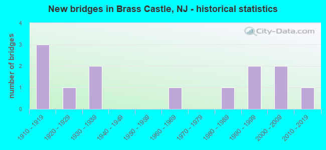
- New bridges - historical statistics
- 31910-1919
- 11920-1929
- 21930-1939
- 11960-1969
- 11980-1989
- 21990-1999
- 22000-2009
- 12010-2019

- Reconstructed bridges - Historical Statistics
- 11950-1959
- 01960-1969
- 01970-1979
- 01980-1989
- 21990-1999
- 02000-2009
- 12010-2019


- Bridge Condition - Deck
- 41.7%Good
- 50.0%Satisfactory
- 8.3%Fair

- Bridge Condition - Superstructure
- 23.1%Very good
- 23.1%Good
- 38.5%Satisfactory
- 15.4%Fair

- Bridge Condition - Substructure
- 69.2%Good
- 30.8%Satisfactory

- Bridge Condition - Channel
- 58.3%Good
- 33.3%Satisfactory
- 8.3%Fair
Find on map >> Show street view
Structure Number: 2100501, Location: 0.4 MI. SOUTH OF NJ 57 (Lat: 40.737750, Lng: -75.025831), Route carried "on" structure: City street , Year Built: 1917, Year Reconstructed: 2015, Status: Open, Structure Length: 1.28m (4.20ft), Average Daily Traffic: 175 (year 2021), Truck Traffic: 1%, Average Future Daily Traffic: 210 (year 2041), Design Load: HL 93, Features Intersected: POHATCONG CREEK, Facility Carried by Structure: BEIDLEMAN ROAD
Minimum Vertical Clearance: 30+ m (98+ ft), Kilometerpoint: 0.000, Lanes on structure: 1, Owner: County Highway Agency, Approaching Roadway Width: 4.3m (14.1ft), Skew: 1 degrees, Material/Design: Wood or Timber, Design/Construction: Slab, Number Of Spans In Main Unit: 1, Length of Maximum Span: 11.9m (39.0ft), Curb-To-Curb Width: 4.2m (13.8ft), Out-to-Out Width: 4.8m (15.7ft)
Condition: Deck: Good, Superstructure: Good, Substructure: Good, Channel: Satisfactory, Operating Rating: 56.4 metric tons, Method Used To Determine Operating Rating: Load and Resistance Factor Rating (LRFR) rating reported by rating factor(RF) method using HL-93 loadings, Inventory Rating: 43.4 metric tons, Method Used To Determine Inventory Rating: Load and Resistance Factor Rating (LRFR) rating reported by rating factor(RF) method using HL-93 loadings, Structural Evaluation: Better than present minimum criteria, Deck Geometry: High priority of replacement, Waterway Adequacy: Better than present minimum criteria, Approach Roadway Alignment: Equal to present desirable criteria, Designated Inspection Frequency: Every 24 months, Inspection Date: March 2021, Deck Structure Type: Wood or Timber, Wearing Surface/Protective System: Wearing Surface: Bituminous, Membrane: Other
Find on map >> Show street view
Structure Number: 2102204, Location: 1.4 MI NORTH OF NJ RT 57 (Lat: 40.776211, Lng: -74.993119), Route carried "on" structure: County highway 649, Year Built: 2001, Status: Open, Structure Length: 1.86m (6.10ft), Average Daily Traffic: 2,490 (year 2021), Truck Traffic: 3%, Average Future Daily Traffic: 3,038 (year 2041), Design Load: HS 20+Mod, Features Intersected: POHATCONG CREEK
Minimum Vertical Clearance: 30+ m (98+ ft), Kilometerpoint: 1.690, Lanes on structure: 2, Owner: County Highway Agency, Approaching Roadway Width: 11.0m (36.1ft), Skew: 1 degrees, Material/Design: Prestressed concrete, Design/Construction: Box Beam or Girders - Multiple, Number Of Spans In Main Unit: 1, Length of Maximum Span: 17.1m (56.1ft), Curb-To-Curb Width: 11.0m (36.1ft), Out-to-Out Width: 12.3m (40.4ft)
Condition: Deck: Satisfactory, Superstructure: Very good, Substructure: Good, Channel: Good, Operating Rating: 81.6 metric tons, Method Used To Determine Operating Rating: Load Factor (LF), Inventory Rating: 49.0 metric tons, Method Used To Determine Inventory Rating: Load Factor (LF), Structural Evaluation: Better than present minimum criteria, Deck Geometry: Somewhat better than minimum adequacy, Waterway Adequacy: Superior to present desirable criteria, Approach Roadway Alignment: Equal to present desirable criteria, Designated Inspection Frequency: Every 24 months, Inspection Date: April 2021, Deck Structure Type: Concrete Cast-file-Place, Wearing Surface/Protective System: Wearing Surface: Monolithic Concrete, Deck Protection: Epoxy Coated Reinforcing
Find on map >> Show street view
Structure Number: 210221, Location: 100 FT.SOUTH OF CR623 (Lat: 40.763561, Lng: -75.010681), Route carried "on" structure: County highway 648, Year Built: 1964, Status: Open, Structure Length: 0.73m (2.40ft), Average Daily Traffic: 891 (year 2021), Truck Traffic: 1%, Average Future Daily Traffic: 1,087 (year 2041), Design Load: H 20, Features Intersected: BRASS CASTLE CREEK
Minimum Vertical Clearance: 30+ m (98+ ft), Kilometerpoint: 2.977, Lanes on structure: 2, Owner: County Highway Agency, Approaching Roadway Width: 7.6m (24.9ft), Skew: 1 degrees, Material/Design: Prestressed concrete, Design/Construction: Slab, Number Of Spans In Main Unit: 1, Length of Maximum Span: 6.7m (22.0ft), Curb-To-Curb Width: 8.4m (27.6ft), Out-to-Out Width: 9.3m (30.5ft)
Condition: Deck: Satisfactory, Superstructure: Satisfactory, Substructure: Good, Channel: Satisfactory, Operating Rating: 64.4 metric tons, Method Used To Determine Operating Rating: Load Factor (LF), Inventory Rating: 39.0 metric tons, Method Used To Determine Inventory Rating: Load Factor (LF), Structural Evaluation: Equal to present minimum criteria, Deck Geometry: Somewhat better than minimum adequacy, Waterway Adequacy: Equal to present minimum criteria, Approach Roadway Alignment: Equal to present desirable criteria, Designated Inspection Frequency: Every 24 months, Inspection Date: March 2021, Deck Structure Type: Concrete Precast Panels, Wearing Surface/Protective System: Wearing Surface: Bituminous
Find on map >> Show street view
Structure Number: 2102214, Location: 0.5 MI. SOUTH NJ 57 (Lat: 40.749039, Lng: -75.005231), Route carried "on" structure: City street , Year Built: 1910, Year Reconstructed: 1956, Status: Open, Structure Length: 0.79m (2.59ft), Average Daily Traffic: 959 (year 2021), Truck Traffic: 1%, Average Future Daily Traffic: 1,170 (year 2041), Features Intersected: POHATCONG CREEK, Facility Carried by Structure: MILL POND ROAD
Minimum Vertical Clearance: 30+ m (98+ ft), Kilometerpoint: 0.000, Lanes on structure: 1, Owner: County Highway Agency, Approaching Roadway Width: 4.0m (13.1ft), Material/Design: Steel, Design/Construction: Stringer/Multi-beam, Number Of Spans In Main Unit: 1, Length of Maximum Span: 7.3m (24.0ft), Curb-To-Curb Width: 4.0m (13.1ft), Out-to-Out Width: 4.6m (15.1ft)
Condition: Deck: Satisfactory, Superstructure: Fair, Substructure: Satisfactory, Channel: Satisfactory, Operating Rating: 38.1 metric tons, Method Used To Determine Operating Rating: Field evaluation and documented engineering judgment, Inventory Rating: 24.5 metric tons, Method Used To Determine Inventory Rating: Field evaluation and documented engineering judgment, Structural Evaluation: Somewhat better than minimum adequacy, Deck Geometry: High priority of replacement, Waterway Adequacy: Better than present minimum criteria, Approach Roadway Alignment: Better than present minimum criteria, Length Of Structure Improvement: 1.40m (4.59ft), Designated Inspection Frequency: Every 24 months, Inspection Date: March 2021, Bridge Improvement Cost: $592,000, Roadway Improvement Cost: $48,000, Total Project Cost: $875,000 ( Estimate for 2019), Deck Structure Type: Concrete Cast-file-Place, Wearing Surface/Protective System: Wearing Surface: Bituminous
Find on map >> Show street view
Structure Number: 2102215, Location: 0.14 MI N OF NJ 57 (Lat: 40.755761, Lng: -74.998950), Route carried "on" structure: County highway 623, Year Built: 2010, Status: Open, Structure Length: 1.43m (4.69ft), Average Daily Traffic: 6,334 (year 2021), Truck Traffic: 4%, Average Future Daily Traffic: 7,729 (year 2041), Design Load: HS 25 or greater, Features Intersected: POHATCONG CREEK
Minimum Vertical Clearance: 30+ m (98+ ft), Kilometerpoint: 0.241, Lanes on structure: 2, Owner: County Highway Agency, Approaching Roadway Width: 12.2m (40.0ft), Skew: 1 degrees, Material/Design: Prestressed concrete, Design/Construction: Box Beam or Girders - Multiple, Number Of Spans In Main Unit: 1, Length of Maximum Span: 13.4m (44.0ft), Curb or Sidewalk Widths: Left: 1.8m (5.9ft), Right: 1.8m (5.9ft), Curb-To-Curb Width: 12.2m (40.0ft), Out-to-Out Width: 16.9m (55.4ft)
Condition: Deck: Satisfactory, Superstructure: Very good, Substructure: Good, Channel: Satisfactory, Operating Rating: 77.1 metric tons, Method Used To Determine Operating Rating: Load Factor (LF), Inventory Rating: 46.3 metric tons, Method Used To Determine Inventory Rating: Load Factor (LF), Structural Evaluation: Better than present minimum criteria, Deck Geometry: Somewhat better than minimum adequacy, Waterway Adequacy: Equal to present desirable criteria, Approach Roadway Alignment: Equal to present desirable criteria, Designated Inspection Frequency: Every 24 months, Inspection Date: April 2021, Deck Structure Type: Concrete Cast-file-Place, Wearing Surface/Protective System: Wearing Surface: Monolithic Concrete, Deck Protection: Epoxy Coated Reinforcing
Find on map >> Show street view
Structure Number: 2102218, Location: 0.5 MI. SOUTH NJ RT57 (Lat: 40.744750, Lng: -75.013581), Route carried "on" structure: City street , Year Built: 1991, Status: Open, Structure Length: 1.58m (5.18ft), Average Daily Traffic: 264 (year 2021), Truck Traffic: 1%, Average Future Daily Traffic: 322 (year 2041), Design Load: HS 20+Mod, Features Intersected: POHATCONG CREEK, Facility Carried by Structure: BUTTERMILK BR. RD.
Minimum Vertical Clearance: 30+ m (98+ ft), Kilometerpoint: 3.042, Lanes on structure: 2, Owner: County Highway Agency, Approaching Roadway Width: 8.5m (27.9ft), Skew: 2 degrees, Material/Design: Prestressed concrete, Design/Construction: Slab, Number Of Spans In Main Unit: 1, Length of Maximum Span: 14.3m (46.9ft), Curb or Sidewalk Widths: Left: 1.5m (4.9ft), Right: 0.0m, Curb-To-Curb Width: 8.5m (27.9ft), Out-to-Out Width: 10.9m (35.8ft)
Condition: Deck: Good, Superstructure: Good, Substructure: Good, Channel: Good, Inventory Rating: 56.2 metric tons, Method Used To Determine Inventory Rating: Load Factor (LF), Structural Evaluation: Better than present minimum criteria, Deck Geometry: Equal to present minimum criteria, Waterway Adequacy: Equal to present desirable criteria, Approach Roadway Alignment: Somewhat better than minimum adequacy, Designated Inspection Frequency: Every 24 months, Inspection Date: April 2021, Deck Structure Type: Concrete Cast-file-Place, Wearing Surface/Protective System: Wearing Surface: Monolithic Concrete, Deck Protection: Epoxy Coated Reinforcing
Find on map >> Show street view
Structure Number: 2102227, Location: 0.3 MI E OF CR 623 (Lat: 40.760081, Lng: -75.000081), Route carried "on" structure: County highway 628, Year Built: 2000, Status: Open, Structure Length: 1.13m (3.71ft), Average Daily Traffic: 2,868 (year 2021), Truck Traffic: 4%, Average Future Daily Traffic: 3,500 (year 2041), Design Load: HS 20+Mod, Features Intersected: POHATCONG CREEK
Minimum Vertical Clearance: 30+ m (98+ ft), Kilometerpoint: 0.274, Lanes on structure: 2, Owner: County Highway Agency, Approaching Roadway Width: 11.9m (39.0ft), Material/Design: Concrete, Design/Construction: Frame, Number Of Spans In Main Unit: 1, Length of Maximum Span: 10.1m (33.1ft), Curb-To-Curb Width: 12.0m (39.4ft), Out-to-Out Width: 13.0m (42.7ft)
Condition: Deck: Good, Superstructure: Good, Substructure: Good, Channel: Good, Operating Rating: 78.9 metric tons, Method Used To Determine Operating Rating: Load Factor (LF), Inventory Rating: 47.2 metric tons, Method Used To Determine Inventory Rating: Load Factor (LF), Structural Evaluation: Better than present minimum criteria, Deck Geometry: Somewhat better than minimum adequacy, Waterway Adequacy: Equal to present desirable criteria, Approach Roadway Alignment: Equal to present desirable criteria, Designated Inspection Frequency: Every 24 months, Inspection Date: March 2021, Deck Structure Type: Concrete Cast-file-Place, Wearing Surface/Protective System: Wearing Surface: Monolithic Concrete, Deck Protection: Epoxy Coated Reinforcing
Find on map >> Show street view
Structure Number: 2102231, Location: 1.08 MI N OF NJ ROUTE 57 (Lat: 40.764861, Lng: -75.012000), Route carried "on" structure: County highway 623, Year Built: 1939, Status: Open, Structure Length: 0.88m (2.89ft), Average Daily Traffic: 6,334 (year 2021), Truck Traffic: 3%, Average Future Daily Traffic: 7,729 (year 2041), Features Intersected: BRASS CASTLE CREEK
Minimum Vertical Clearance: 30+ m (98+ ft), Kilometerpoint: 1.738, Lanes on structure: 2, Owner: County Highway Agency, Approaching Roadway Width: 8.8m (28.9ft), Skew: 4 degrees, Material/Design: Steel, Design/Construction: Stringer/Multi-beam, Number Of Spans In Main Unit: 1, Length of Maximum Span: 7.3m (24.0ft), Curb-To-Curb Width: 8.9m (29.2ft), Out-to-Out Width: 10.1m (33.1ft)
Condition: Deck: Good, Superstructure: Fair, Substructure: Satisfactory, Channel: Good, Operating Rating: 56.2 metric tons, Method Used To Determine Operating Rating: Load Factor (LF), Inventory Rating: 33.6 metric tons, Method Used To Determine Inventory Rating: Load Factor (LF), Structural Evaluation: Somewhat better than minimum adequacy, Deck Geometry: High priority of replacement, Waterway Adequacy: Equal to present desirable criteria, Approach Roadway Alignment: Better than present minimum criteria, Length Of Structure Improvement: 0.88m (2.89ft), Designated Inspection Frequency: Every 24 months, Inspection Date: March 2021, Bridge Improvement Cost: $71,000, Roadway Improvement Cost: $56,000, Total Project Cost: $168,000 ( Estimate for 2019), Deck Structure Type: Concrete Cast-file-Place, Wearing Surface/Protective System: Wearing Surface: Bituminous
Find on map >> Show street view
Structure Number: 2102251, Location: 0.8 MILES NORTH OF NJ 57 (Lat: 40.759339, Lng: -75.012050), Route carried "on" structure: City street , Year Built: 1936, Year Reconstructed: 2004, Status: Open, Structure Length: 0.79m (2.59ft), Average Daily Traffic: 330 (year 2021), Truck Traffic: 1%, Average Future Daily Traffic: 400 (year 2041), Features Intersected: BRASS CASTLE CREEK, Facility Carried by Structure: MEADOW BREEZE LANE
Minimum Vertical Clearance: 30+ m (98+ ft), Kilometerpoint: 0.000, Lanes on structure: 2, Owner: County Highway Agency, Approaching Roadway Width: 6.1m (20.0ft), Material/Design: Prestressed concrete, Design/Construction: Slab, Number Of Spans In Main Unit: 1, Length of Maximum Span: 6.7m (22.0ft), Curb-To-Curb Width: 7.8m (25.6ft), Out-to-Out Width: 8.7m (28.5ft)
Condition: Deck: Satisfactory, Superstructure: Satisfactory, Substructure: Good, Channel: Good, Operating Rating: 54.4 metric tons, Method Used To Determine Operating Rating: Field evaluation and documented engineering judgment, Inventory Rating: 32.7 metric tons, Method Used To Determine Inventory Rating: Field evaluation and documented engineering judgment, Structural Evaluation: Equal to present minimum criteria, Deck Geometry: Somewhat better than minimum adequacy, Waterway Adequacy: Equal to present desirable criteria, Approach Roadway Alignment: Meets minimum limits, Designated Inspection Frequency: Every 24 months, Inspection Date: March 2021, Deck Structure Type: Concrete Precast Panels, Wearing Surface/Protective System: Wearing Surface: Bituminous, Membrane: Preformed Fabric
Find on map >> Show street view
Structure Number: 2102252, Location: 0.67 Miles North of NJ 57 (Lat: 40.757319, Lng: -75.016281), Route carried "on" structure: City street , Year Built: 1995, Status: Open, Structure Length: 0.85m (2.79ft), Average Daily Traffic: 1,820 (year 2021), Truck Traffic: 1%, Average Future Daily Traffic: 2,180 (year 2041), Design Load: HS 25 or greater, Features Intersected: BRASS CASTLE CREEK, Facility Carried by Structure: KAYHARTS LANE
Minimum Vertical Clearance: 30+ m (98+ ft), Kilometerpoint: 0.000, Lanes on structure: 2, Owner: County Highway Agency, Approaching Roadway Width: 7.3m (24.0ft), Material/Design: Concrete, Design/Construction: Arch - Deck, Number Of Spans In Main Unit: 1, Length of Maximum Span: 8.5m (27.9ft), Curb-To-Curb Width: 8.4m (27.6ft), Out-to-Out Width: 9.6m (31.5ft)
Condition: Superstructure: Satisfactory, Substructure: Good, Channel: Good, Structural Evaluation: Equal to present minimum criteria, Deck Geometry: Meets minimum limits, Waterway Adequacy: Better than present minimum criteria, Approach Roadway Alignment: Equal to present minimum criteria, Designated Inspection Frequency: Every 24 months, Inspection Date: April 2021
Find on map >> Show street view
Structure Number: 2105163, Location: 2.2 MI WEST OF RT 31 JCT (Lat: 40.748150, Lng: -75.014039), Route carried "on" structure: State highway 57, Year Built: 1921, Status: Open, Structure Length: 0.79m (2.59ft), Average Daily Traffic: 17,783 (year 2021), Truck Traffic: 4%, Average Future Daily Traffic: 24,897 (year 2041), Features Intersected: BRASS CASTLE CREEK
Minimum Vertical Clearance: 30+ m (98+ ft), Kilometerpoint: 14.178, Lanes on structure: 2, Base Highway Network: Yes, Owner: State Highway Agency, Approaching Roadway Width: 12.2m (40.0ft), Material/Design: Steel, Design/Construction: Stringer/Multi-beam, Number Of Spans In Main Unit: 1, Length of Maximum Span: 6.7m (22.0ft), Curb-To-Curb Width: 8.8m (28.9ft), Out-to-Out Width: 9.9m (32.5ft)
Condition: Deck: Fair, Superstructure: Satisfactory, Substructure: Satisfactory, Channel: Fair, Operating Rating: 41.7 metric tons, Method Used To Determine Operating Rating: Load Factor (LF), Inventory Rating: 25.4 metric tons, Method Used To Determine Inventory Rating: Load Factor (LF), Structural Evaluation: Equal to present minimum criteria, Deck Geometry: High priority of replacement, Waterway Adequacy: Superior to present desirable criteria, Approach Roadway Alignment: Equal to present desirable criteria, Length Of Structure Improvement: 0.79m (2.59ft), Designated Inspection Frequency: Every 24 months, Inspection Date: March 2021, Bridge Improvement Cost: $150,000, Roadway Improvement Cost: $15,000, Total Project Cost: $228,000 ( Estimate for 2021), Deck Structure Type: Concrete Cast-file-Place, Wearing Surface/Protective System: Wearing Surface: Bituminous
Find on map >> Show street view
Structure Number: 2105164, Location: 1.47 MI WEST OF ROUTE 31 (Lat: 40.752519, Lng: -75.001369), Route carried "on" structure: State highway 57, Year Built: 1984, Status: Open, Structure Length: 1.98m (6.50ft), Average Daily Traffic: 17,431 (year 2021), Truck Traffic: 4%, Average Future Daily Traffic: 20,918 (year 2041), Design Load: HS 20+Mod, Features Intersected: POHATCONG CREEK
Minimum Vertical Clearance: 30+ m (98+ ft), Kilometerpoint: 15.369, Lanes on structure: 2, Base Highway Network: Yes, Owner: State Highway Agency, Approaching Roadway Width: 13.4m (44.0ft), Material/Design: Prestressed concrete, Design/Construction: Box Beam or Girders - Multiple, Number Of Spans In Main Unit: 1, Length of Maximum Span: 18.6m (61.0ft), Curb or Sidewalk Widths: Left: 2.1m (6.9ft), Right: 2.1m (6.9ft), Curb-To-Curb Width: 13.4m (44.0ft), Out-to-Out Width: 18.4m (60.4ft)
Condition: Deck: Satisfactory, Superstructure: Satisfactory, Substructure: Good, Channel: Good, Operating Rating: 58.1 metric tons, Method Used To Determine Operating Rating: Load Factor (LF), Inventory Rating: 29.9 metric tons, Method Used To Determine Inventory Rating: Load Factor (LF), Structural Evaluation: Equal to present minimum criteria, Deck Geometry: Equal to present minimum criteria, Waterway Adequacy: Superior to present desirable criteria, Approach Roadway Alignment: Equal to present desirable criteria, Length Of Structure Improvement: 1.98m (6.50ft), Designated Inspection Frequency: Every 24 months, Inspection Date: April 2021, Deck Structure Type: Concrete Cast-file-Place, Wearing Surface/Protective System: Wearing Surface: Monolithic Concrete, Deck Protection: Epoxy Coated Reinforcing
Find on map >> Show street view
Structure Number: 2154163, Location: 2.3MI SW OF NJ31&NJ57 JCT (Lat: 40.742331, Lng: -75.012150), Route carried "on" structure: City street , Year Built: 1916, Year Reconstructed: 1997, Status: Open, Structure Length: 1.19m (3.90ft), Average Daily Traffic: 190 (year 2021), Truck Traffic: 3%, Average Future Daily Traffic: 232 (year 2041), Design Load: HS 20+Mod, Features Intersected: WASHINGTON SEC (NS), Facility Carried by Structure: BUTTRMLK BRIDGE RD
Minimum Vertical Clearance: 30+ m (98+ ft), Kilometerpoint: 0.000, Lanes on structure: 2, Maintenance Responsibility: State Highway Agency, Approaching Roadway Width: 6.1m (20.0ft), Skew: 1 degrees, Material/Design: Prestressed concrete, Design/Construction: Slab, Number Of Spans In Main Unit: 1, Length of Maximum Span: 10.7m (35.1ft), Curb-To-Curb Width: 6.0m (19.7ft), Out-to-Out Width: 7.0m (23.0ft)
Condition: Deck: Good, Superstructure: Very good, Substructure: Satisfactory, Inventory Rating: 57.2 metric tons, Method Used To Determine Inventory Rating: Load Factor (LF), Structural Evaluation: Equal to present minimum criteria, Deck Geometry: High priority of corrective action, Underclear: High priority of replacement, Approach Roadway Alignment: High priority of corrective action, Length Of Structure Improvement: 1.83m (6.00ft), Designated Inspection Frequency: Every 24 months, Inspection Date: September 2021, Bridge Improvement Cost: $639,000, Roadway Improvement Cost: $50,000, Total Project Cost: $1,357,000 ( Estimate for 2021), Deck Structure Type: Concrete Cast-file-Place, Wearing Surface/Protective System: Wearing Surface: Monolithic Concrete, Deck Protection: Epoxy Coated Reinforcing