Bridge Statistics for Brewster, Kansas (KS)
Condition, Traffic, Stress, Structural Evaluation, Project Costs
- National Bridge Inventory (NBI) Statistics
- 10Number of bridges
- 92ft / 28.0mTotal length
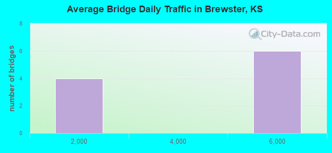
- 33,221Total average daily traffic
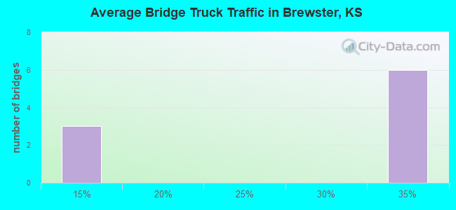
- 10,962Total average daily truck traffic
- National Bridge Inventory (NBI) Registered Bridges for Brewster
- No street view available for this location
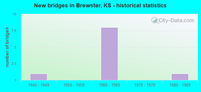
- New bridges - historical statistics
- 11940-1949
- 81960-1969
- 11980-1989
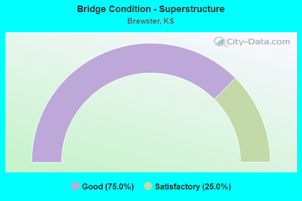
- Bridge Condition - Superstructure
- 75.0%Good
- 25.0%Satisfactory

- Bridge Condition - Channel
- 75.0%Good
- 25.0%Satisfactory
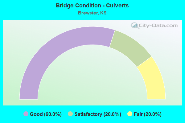
- Bridge Condition - Culverts
- 60.0%Good
- 20.0%Satisfactory
- 20.0%Fair
Find on map >> Show street view
Structure Number: 9104, Location: 2.0N 15.2E OF GOODLAND (Lat: 39.366597, Lng: -101.421950), Route carried "on" structure: County highway 883, Year Built: 1968, Status: Open, Structure Length: 1.55m (5.09ft), Average Daily Traffic: 140 (year 2014), Truck Traffic: 10%, Average Future Daily Traffic: 160 (year 2040), Design Load: H 15, Features Intersected: TRIB S FORK SAPPA CREEK, Facility Carried by Structure: 66 ROAD
Minimum Vertical Clearance: 30.47m (99.97ft), Kilometerpoint: 0.000, Lanes on structure: 2, Owner: County Highway Agency, Approaching Roadway Width: 7.8m (25.6ft), Material/Design: Concrete, Design/Construction: Culvert, Number Of Spans In Main Unit: 4, Length of Maximum Span: 3.7m (12.1ft), Curb-To-Curb Width: 8.8m (28.9ft), Out-to-Out Width: 9.6m (31.5ft)
Condition: Channel: Good, Culverts: Good, Operating Rating: 29.9 metric tons, Method Used To Determine Operating Rating: Load Factor (LF), Inventory Rating: 18.1 metric tons, Method Used To Determine Inventory Rating: Load Factor (LF), Structural Evaluation: Somewhat better than minimum adequacy, Deck Geometry: Equal to present minimum criteria, Waterway Adequacy: Equal to present desirable criteria, Approach Roadway Alignment: Equal to present desirable criteria, Designated Inspection Frequency: Every 24 months, Inspection Date: June 2020, Wearing Surface/Protective System: Wearing Surface: Gravel
Find on map >> Show street view
Structure Number: 97004, Location: 0.7N OF BREWSTER (Lat: 39.377481, Lng: -101.372192), Route carried "on" structure: County highway 410, Year Built: 1948, Status: Open, Structure Length: 2.70m (8.86ft), Average Daily Traffic: 355 (year 2014), Truck Traffic: 10%, Average Future Daily Traffic: 400 (year 2040), Design Load: H 15, Features Intersected: TRIB TO S FORK SAPPA, Facility Carried by Structure: County Rd 2 (40)
Minimum Vertical Clearance: 30.47m (99.97ft), Kilometerpoint: 0.161, Lanes on structure: 2, Owner: County Highway Agency, Approaching Roadway Width: 6.7m (22.0ft), Material/Design: Concrete, Design/Construction: Culvert, Number Of Spans In Main Unit: 6, Length of Maximum Span: 4.3m (14.1ft), Curb or Sidewalk Widths: Left: 0.3m (1.0ft), Right: 0.3m (1.0ft), Curb-To-Curb Width: 7.9m (25.9ft), Out-to-Out Width: 8.5m (27.9ft)
Condition: Channel: Satisfactory, Culverts: Good, Operating Rating: 41.9 metric tons, Method Used To Determine Operating Rating: Load Factor (LF), Inventory Rating: 25.0 metric tons, Method Used To Determine Inventory Rating: Load Factor (LF), Structural Evaluation: Equal to present minimum criteria, Deck Geometry: Somewhat better than minimum adequacy, Waterway Adequacy: Equal to present desirable criteria, Approach Roadway Alignment: Equal to present desirable criteria, Designated Inspection Frequency: Every 24 months, Inspection Date: June 2020, Wearing Surface/Protective System: Wearing Surface: Bituminous
Find on map >> Show street view
Structure Number: 97023, Location: 2.3S OF BREWSTER (Lat: 39.326400, Lng: -101.372450), Route carried "on" structure: County highway 1513, Year Built: 1981, Status: Open, Structure Length: 4.04m (13.25ft), Average Daily Traffic: 175 (year 2014), Truck Traffic: 10%, Average Future Daily Traffic: 190 (year 2040), Design Load: H 20, Features Intersected: SOUTH FORK SAPPA CREEK, Facility Carried by Structure: County Rd 2 (230)
Minimum Vertical Clearance: 30.47m (99.97ft), Kilometerpoint: 23.014, Lanes on structure: 2, Owner: County Highway Agency, Approaching Roadway Width: 8.5m (27.9ft), Material/Design: Concrete continuous, Design/Construction: Tee Beam, Number Of Spans In Main Unit: 3, Length of Maximum Span: 15.2m (49.9ft), Curb-To-Curb Width: 8.5m (27.9ft), Out-to-Out Width: 9.1m (29.9ft)
Condition: Deck: Good, Superstructure: Good, Substructure: Good, Channel: Good, Operating Rating: 36.9 metric tons, Method Used To Determine Operating Rating: Load Factor (LF), Inventory Rating: 22.0 metric tons, Method Used To Determine Inventory Rating: Load Factor (LF), Structural Evaluation: Equal to present minimum criteria, Deck Geometry: Equal to present minimum criteria, Waterway Adequacy: Equal to present desirable criteria, Approach Roadway Alignment: Equal to present desirable criteria, Designated Inspection Frequency: Every 24 months, Inspection Date: June 2020, Deck Structure Type: Concrete Cast-file-Place, Wearing Surface/Protective System: Wearing Surface: Monolithic Concrete
Find on map >> Show street view
Structure Number: 999907000910391, Location: 1.01 MI W. OF TH. CO L (Lat: 39.330278, Lng: -101.409722), Route carried "on" structure: Interstate 70, Year Built: 1968, Status: Open, Structure Length: 0.73m (2.40ft), Average Daily Traffic: 5,511 (year 2020), Truck Traffic: 33%, Average Future Daily Traffic: 7,874 (year 2041), Design Load: HS 20+Mod, Features Intersected: LOCAL ROAD
Minimum Vertical Clearance: 30.47m (99.97ft), Kilometerpoint: 55.149, Lanes on structure: 4, Lanes under structure: 2, Base Highway Network: Yes, Owner: State Highway Agency, Approaching Roadway Width: 24.4m (80.1ft), Skew: 20 degrees, Material/Design: Concrete, Design/Construction: Culvert, Number Of Spans In Main Unit: 1, Length of Maximum Span: 7.3m (24.0ft), Curb-To-Curb Width: 24.4m (80.1ft), Out-to-Out Width: 39.6m (129.9ft)
Condition: Culverts: Good, Operating Rating: 63.2 metric tons, Method Used To Determine Operating Rating: Load Factor (LF), Inventory Rating: 37.9 metric tons, Method Used To Determine Inventory Rating: Load Factor (LF), Structural Evaluation: Better than present minimum criteria, Deck Geometry: Superior to present desirable criteria, Underclear: High priority of corrective action, Approach Roadway Alignment: Equal to present desirable criteria, Length Of Structure Improvement: 2.40m (7.87ft), Designated Inspection Frequency: Every 24 months, Inspection Date: June 2020, Deck Structure Type: Concrete Cast-file-Place, Wearing Surface/Protective System: Wearing Surface: Bituminous
Find on map >> Show street view
Structure Number: 999907000910401, Location: SHERMAN-THOMAS CO. LN. (Lat: 39.330833, Lng: -101.390833), Route carried "on" structure: ServiceCounty highway 387, Year Built: 1968, Status: Open, Structure Length: 7.93m (26.02ft), Average Daily Traffic: 10 (year 2020), Average Future Daily Traffic: 7,215 (year 2041), Design Load: H 15, Features Intersected: I-70 HIGHWAY, Facility Carried by Structure: LOCAL ROAD
Minimum Vertical Clearance: 30.47m (99.97ft), Kilometerpoint: 3.956, Lanes on structure: 2, Lanes under structure: 4, Owner: State Highway Agency, Approaching Roadway Width: 8.5m (27.9ft), Material/Design: Concrete continuous, Design/Construction: Box Beam or Girders - Multiple, Number Of Spans In Main Unit: 4, Length of Maximum Span: 21.8m (71.5ft), Curb-To-Curb Width: 7.3m (24.0ft), Out-to-Out Width: 8.1m (26.6ft)
Condition: Deck: Good, Superstructure: Good, Substructure: Good, Operating Rating: 63.6 metric tons, Method Used To Determine Operating Rating: Load Factor (LF), Inventory Rating: 38.1 metric tons, Method Used To Determine Inventory Rating: Load Factor (LF), Structural Evaluation: Better than present minimum criteria, Deck Geometry: Equal to present minimum criteria, Underclear: Equal to present minimum criteria, Approach Roadway Alignment: Somewhat better than minimum adequacy, Length Of Structure Improvement: 26.00m (85.30ft), Designated Inspection Frequency: Every 24 months, Inspection Date: June 2020, Deck Structure Type: Concrete Cast-file-Place, Wearing Surface/Protective System: Wearing Surface: Monolithic Concrete
Find on map >> Show street view
Structure Number: 999907000970011, Location: 0.38 MI E. OF SH CO. L (Lat: 39.333333, Lng: -101.384444), Route carried "on" structure: Interstate 70, Year Built: 1967, Status: Open, Structure Length: 0.88m (2.89ft), Average Daily Traffic: 5,511 (year 2020), Truck Traffic: 33%, Average Future Daily Traffic: 7,874 (year 2041), Design Load: HS 20+Mod, Features Intersected: SOUTH FORK SAPPA CREEK
Minimum Vertical Clearance: 30.47m (99.97ft), Kilometerpoint: 0.618, Lanes on structure: 4, Base Highway Network: Yes, Owner: State Highway Agency, Approaching Roadway Width: 24.4m (80.1ft), Skew: 20 degrees, Material/Design: Concrete, Design/Construction: Culvert, Number Of Spans In Main Unit: 2, Length of Maximum Span: 4.3m (14.1ft), Curb-To-Curb Width: 24.4m (80.1ft), Out-to-Out Width: 59.7m (195.9ft)
Condition: Channel: Good, Culverts: Satisfactory, Operating Rating: 84.4 metric tons, Method Used To Determine Operating Rating: Load Factor (LF), Inventory Rating: 50.8 metric tons, Method Used To Determine Inventory Rating: Load Factor (LF), Structural Evaluation: Equal to present minimum criteria, Deck Geometry: Superior to present desirable criteria, Waterway Adequacy: Equal to present desirable criteria, Approach Roadway Alignment: Equal to present desirable criteria, Length Of Structure Improvement: 2.88m (9.45ft), Designated Inspection Frequency: Every 24 months, Inspection Date: June 2020, Deck Structure Type: Concrete Cast-file-Place, Wearing Surface/Protective System: Wearing Surface: Bituminous
Find on map >> Show street view
Structure Number: 999907000970021, Location: 1.15 MI E. OF SH CO. L (Lat: 39.339444, Lng: -101.372222), Route carried "on" structure: Interstate 70, Year Built: 1968, Status: Open, Structure Length: 4.68m (15.35ft), Average Daily Traffic: 5,336 (year 2020), Truck Traffic: 34%, Average Future Daily Traffic: 7,624 (year 2041), Design Load: HS 20+Mod, Features Intersected: K-184 HWY
Minimum Vertical Clearance: 30.47m (99.97ft), Kilometerpoint: 1.864, Lanes on structure: 2, Lanes under structure: 2, Base Highway Network: Yes, Owner: State Highway Agency, Approaching Roadway Width: 12.2m (40.0ft), Skew: 3 degrees, Material/Design: Concrete continuous, Design/Construction: Slab, Number Of Spans In Main Unit: 3, Length of Maximum Span: 18.3m (60.0ft), Curb-To-Curb Width: 12.2m (40.0ft), Out-to-Out Width: 12.8m (42.0ft)
Condition: Deck: Good, Superstructure: Satisfactory, Substructure: Good, Operating Rating: 61.7 metric tons, Method Used To Determine Operating Rating: Load Factor (LF), Inventory Rating: 37.2 metric tons, Method Used To Determine Inventory Rating: Load Factor (LF), Structural Evaluation: Equal to present minimum criteria, Deck Geometry: Better than present minimum criteria, Underclear: Equal to present minimum criteria, Approach Roadway Alignment: Equal to present desirable criteria, Length Of Structure Improvement: 15.35m (50.36ft), Designated Inspection Frequency: Every 24 months, Inspection Date: June 2020, Deck Structure Type: Concrete Cast-file-Place, Wearing Surface/Protective System: Wearing Surface: Low Slump Concrete
Find on map >> Show street view
Structure Number: 999907000970031, Location: 1.16 MI E. OF SH CO. L (Lat: 39.339167, Lng: -101.372222), Route carried "on" structure: Interstate 70, Year Built: 1968, Status: Open, Structure Length: 4.68m (15.35ft), Average Daily Traffic: 5,336 (year 2020), Truck Traffic: 34%, Average Future Daily Traffic: 7,624 (year 2041), Design Load: HS 20+Mod, Features Intersected: K184 HWY
Minimum Vertical Clearance: 30.47m (99.97ft), Kilometerpoint: 1.862, Lanes on structure: 2, Lanes under structure: 2, Base Highway Network: Yes, Owner: State Highway Agency, Approaching Roadway Width: 12.2m (40.0ft), Skew: 3 degrees, Material/Design: Concrete continuous, Design/Construction: Slab, Number Of Spans In Main Unit: 3, Length of Maximum Span: 18.3m (60.0ft), Curb-To-Curb Width: 12.2m (40.0ft), Out-to-Out Width: 12.8m (42.0ft)
Condition: Deck: Good, Superstructure: Good, Substructure: Good, Operating Rating: 61.7 metric tons, Method Used To Determine Operating Rating: Load Factor (LF), Inventory Rating: 37.2 metric tons, Method Used To Determine Inventory Rating: Load Factor (LF), Structural Evaluation: Better than present minimum criteria, Deck Geometry: Better than present minimum criteria, Underclear: Better than present minimum criteria, Approach Roadway Alignment: Equal to present desirable criteria, Length Of Structure Improvement: 15.35m (50.36ft), Designated Inspection Frequency: Every 24 months, Inspection Date: June 2020, Deck Structure Type: Concrete Cast-file-Place, Wearing Surface/Protective System: Wearing Surface: Epoxy Overlay
Find on map >> Show street view
Structure Number: 999907000970041, Location: 1.36 MI E. OF K-184 (Lat: 39.349722, Lng: -101.350556), Route carried "on" structure: Interstate 70, Year Built: 1968, Status: Open, Structure Length: 0.85m (2.79ft), Average Daily Traffic: 5,336 (year 2020), Truck Traffic: 34%, Average Future Daily Traffic: 7,624 (year 2041), Design Load: HS 20+Mod, Features Intersected: COUNTY ROAD
Minimum Vertical Clearance: 30.47m (99.97ft), Kilometerpoint: 4.062, Lanes on structure: 4, Lanes under structure: 2, Base Highway Network: Yes, Owner: State Highway Agency, Approaching Roadway Width: 24.4m (80.1ft), Skew: 20 degrees, Material/Design: Concrete, Design/Construction: Culvert, Number Of Spans In Main Unit: 1, Length of Maximum Span: 8.5m (27.9ft), Curb-To-Curb Width: 24.4m (80.1ft), Out-to-Out Width: 39.5m (129.6ft)
Condition: Culverts: Fair, Operating Rating: 61.7 metric tons, Method Used To Determine Operating Rating: Load Factor (LF), Inventory Rating: 36.3 metric tons, Method Used To Determine Inventory Rating: Load Factor (LF), Structural Evaluation: Somewhat better than minimum adequacy, Deck Geometry: Superior to present desirable criteria, Underclear: High priority of corrective action, Approach Roadway Alignment: Equal to present desirable criteria, Length Of Structure Improvement: 2.80m (9.19ft), Designated Inspection Frequency: Every 24 months, Inspection Date: June 2020, Deck Structure Type: Concrete Cast-file-Place, Wearing Surface/Protective System: Wearing Surface: Bituminous
Find on map >> Show street view
Structure Number: 999907000910401, Location: SHERMAN-THOMAS CO. LN. (Lat: 39.330833, Lng: -101.390833), Route carried "under" structure: Interstate 70, Year Built: 1968, Structure Length: 0. m, Average Daily Traffic: 5,511 (year 2020), Truck Traffic: 33%, Features Intersected: I-70 HIGHWAY, Facility Carried by Structure: LOCAL ROAD
Minimum Vertical Clearance: 5.14m (16.86ft), Kilometerpoint: 56.774, Lanes on structure: 2, Lanes under structure: 4, Material/Design: Concrete continuous, Design/Construction: Box Beam or Girders - Multiple, Length of Maximum Span: 21.8m (71.5ft)