Bridge Statistics for Briarcliff Manor, New York (NY)
Condition, Traffic, Stress, Structural Evaluation, Project Costs
- National Bridge Inventory (NBI) Statistics
- 17Number of bridges
- 66ft / 20.0mTotal length
- $23,080,000Total costs
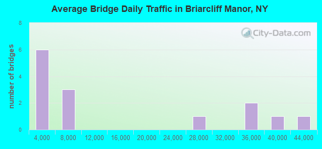
- 198,218Total average daily traffic
- 4,565Total average daily truck traffic
- National Bridge Inventory (NBI) Registered Bridges for Briarcliff Manor
- No street view available for this location
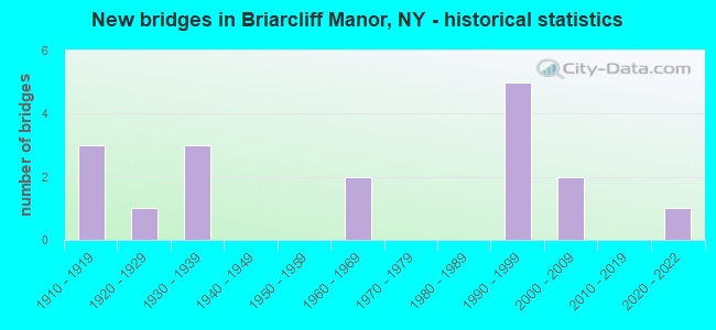
- New bridges - historical statistics
- 31910-1919
- 11920-1929
- 31930-1939
- 21960-1969
- 51990-1999
- 22000-2009
- 12020-2022
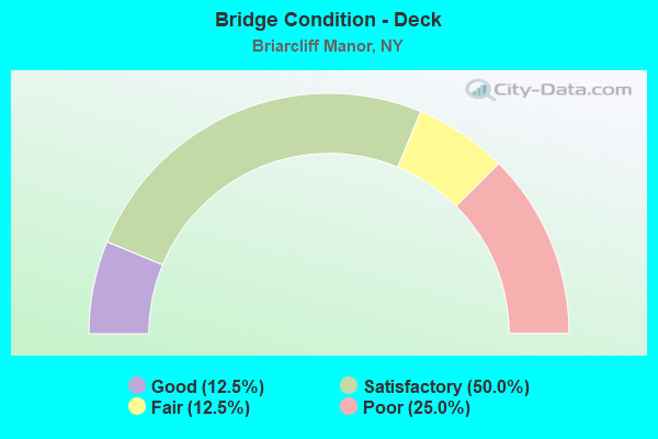
- Bridge Condition - Deck
- 12.5%Good
- 50.0%Satisfactory
- 12.5%Fair
- 25.0%Poor
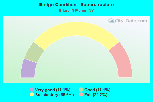
- Bridge Condition - Superstructure
- 11.1%Very good
- 11.1%Good
- 55.6%Satisfactory
- 22.2%Fair
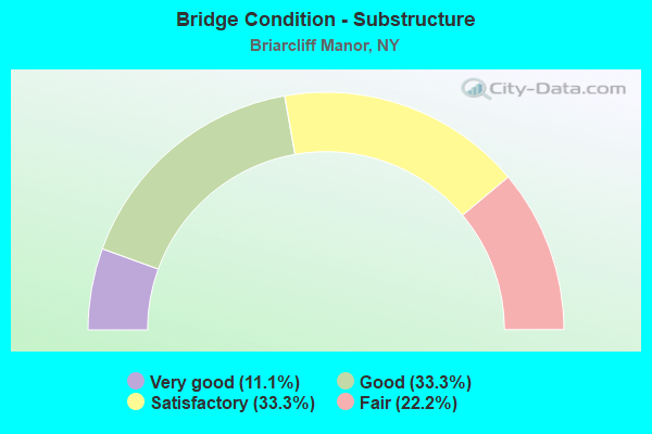
- Bridge Condition - Substructure
- 11.1%Very good
- 33.3%Good
- 33.3%Satisfactory
- 22.2%Fair
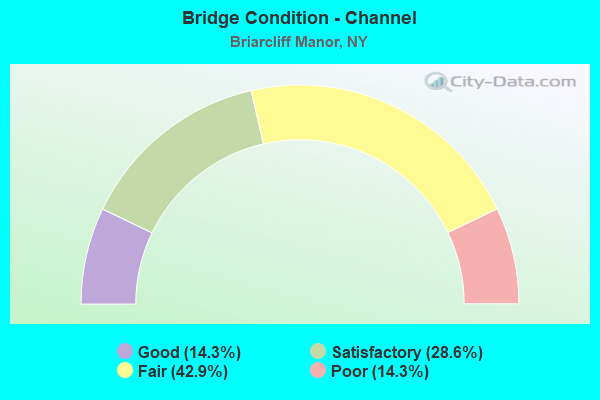
- Bridge Condition - Channel
- 14.3%Good
- 28.6%Satisfactory
- 42.9%Fair
- 14.3%Poor
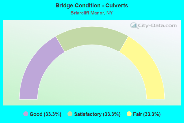
- Bridge Condition - Culverts
- 33.3%Good
- 33.3%Satisfactory
- 33.3%Fair
Find on map >> Show street view
Structure Number: 100616, Location: 1.5 MI N JCT SH9A & SH117 (Lat: 41.145683, Lng: -73.823333), Route carried "on" structure: County highway , Year Built: 1932, Status: Open, Structure Length: 1.72m (5.64ft), Average Daily Traffic: 6,939 (year 2018), Truck Traffic: 3%, Average Future Daily Traffic: 8,429 (year 2040), Design Load: HS 20, Features Intersected: RTE 9A, 9A 9A87032131 N, Facility Carried by Structure: PLEASANTVLLE ROAD
Minimum Vertical Clearance: 30+ m (98+ ft), Kilometerpoint: 0.241, Lanes on structure: 2, Lanes under structure: 4, Owner: State Highway Agency, Approaching Roadway Width: 12.2m (40.0ft), Material/Design: Concrete, Design/Construction: Frame, Number Of Spans In Main Unit: 1, Length of Maximum Span: 14.3m (46.9ft), Curb or Sidewalk Widths: Left: 1.8m (5.9ft), Right: 1.8m (5.9ft), Curb-To-Curb Width: 12.3m (40.4ft), Out-to-Out Width: 16.8m (55.1ft)
Condition: Deck: Satisfactory, Superstructure: Satisfactory, Substructure: Satisfactory, Operating Rating: 82.7 metric tons, Method Used To Determine Operating Rating: Field evaluation and documented engineering judgment, Inventory Rating: 32.7 metric tons, Method Used To Determine Inventory Rating: Field evaluation and documented engineering judgment, Structural Evaluation: Equal to present minimum criteria, Deck Geometry: Somewhat better than minimum adequacy, Underclear: High priority of corrective action, Approach Roadway Alignment: Meets minimum limits, Length Of Structure Improvement: 1.72m (5.64ft), Designated Inspection Frequency: Every 24 months, Inspection Date: July 2020, Bridge Improvement Cost: $1,474,000, Roadway Improvement Cost: $863,000, Total Project Cost: $2,338,000 ( Estimate for 2021), Wearing Surface/Protective System: Wearing Surface: Bituminous
Find on map >> Show street view
Structure Number: 100617, Location: 1.9 MI N JCT RTS 9A+117 (Lat: 41.147964, Lng: -73.823556), Route carried "on" structure: State highway 9A, Year Built: 1928, Year Reconstructed: 2001, Status: Open, Structure Length: 1.19m (3.90ft), Average Daily Traffic: 38,538 (year 2011), Truck Traffic: 6%, Average Future Daily Traffic: 38,719 (year 2040), Design Load: HS 20, Features Intersected: POCANTICO RIVER
Minimum Vertical Clearance: 30+ m (98+ ft), Kilometerpoint: 30.651, Lanes on structure: 4, Base Highway Network: Yes, Owner: State Highway Agency, Approaching Roadway Width: 15.8m (51.8ft), Skew: 20 degrees, Material/Design: Concrete, Design/Construction: Arch - Deck, Number Of Spans In Main Unit: 1, Length of Maximum Span: 6.0m (19.7ft), Curb-To-Curb Width: 14.5m (47.6ft), Out-to-Out Width: 17.6m (57.7ft)
Condition: Deck: Poor, Superstructure: Fair, Substructure: Good, Channel: Fair, Operating Rating: 76.5 metric tons, Method Used To Determine Operating Rating: Field evaluation and documented engineering judgment, Inventory Rating: 29.4 metric tons, Method Used To Determine Inventory Rating: Field evaluation and documented engineering judgment, Structural Evaluation: Somewhat better than minimum adequacy, Deck Geometry: High priority of replacement, Waterway Adequacy: Equal to present desirable criteria, Approach Roadway Alignment: Equal to present desirable criteria, Length Of Structure Improvement: 1.18m (3.87ft), Designated Inspection Frequency: Every 24 months, Inspection Date: May 2020, Bridge Improvement Cost: $793,000, Roadway Improvement Cost: $464,000, Total Project Cost: $1,257,000 ( Estimate for 2021), Deck Structure Type: Concrete Cast-file-Place, Wearing Surface/Protective System: Wearing Surface: Bituminous, Membrane: Preformed Fabric
Find on map >> Show street view
Structure Number: 105334, Location: .1 MI N PLSNTVL RD & 100 (Lat: 41.150614, Lng: -73.826528), Route carried "on" structure: Ramp State highway , Year Built: 1967, Status: Open, Structure Length: 0.82m (2.69ft), Average Daily Traffic: 299 (year 2018), Truck Traffic: 15%, Average Future Daily Traffic: 300 (year 2040), Features Intersected: POCANTICO RIVER, Facility Carried by Structure: RT 100 RAMP TO 9A
Minimum Vertical Clearance: 30+ m (98+ ft), Kilometerpoint: 0.161, Lanes on structure: 1, Owner: State Highway Agency, Approaching Roadway Width: 9.8m (32.2ft), Material/Design: Concrete continuous, Design/Construction: Culvert, Number Of Spans In Main Unit: 2, Length of Maximum Span: 3.6m (11.8ft)
Condition: Channel: Fair, Culverts: Good, Operating Rating: 76.5 metric tons, Method Used To Determine Operating Rating: Load and Resistance Factor Rating (LRFR) rating reported by rating factor(RF) method using HL-93 loadings, Inventory Rating: 59.0 metric tons, Method Used To Determine Inventory Rating: Load and Resistance Factor Rating (LRFR) rating reported by rating factor(RF) method using HL-93 loadings, Structural Evaluation: Better than present minimum criteria, Waterway Adequacy: Superior to present desirable criteria, Approach Roadway Alignment: Equal to present desirable criteria, Length Of Structure Improvement: 0.82m (2.69ft), Designated Inspection Frequency: Every 24 months, Inspection Date: May 2020, Bridge Improvement Cost: $427,000, Roadway Improvement Cost: $250,000, Total Project Cost: $677,000 ( Estimate for 2021), Deck Structure Type: Concrete Cast-file-Place, Wearing Surface/Protective System: Wearing Surface: Bituminous, Membrane: Preformed Fabric
Find on map >> Show street view
Structure Number: 105335, Location: .2 MI N JCT RTE 100+9A (Lat: 41.151953, Lng: -73.825811), Route carried "on" structure: State highway 100, Year Built: 1967, Status: Open, Structure Length: 0.88m (2.89ft), Average Daily Traffic: 299 (year 2018), Truck Traffic: 15%, Average Future Daily Traffic: 300 (year 2040), Features Intersected: POCANTICO RIVER
Minimum Vertical Clearance: 30+ m (98+ ft), Kilometerpoint: 0.016, Lanes on structure: 2, Owner: State Highway Agency, Approaching Roadway Width: 14.6m (47.9ft), Skew: 3 degrees, Material/Design: Concrete continuous, Design/Construction: Culvert, Number Of Spans In Main Unit: 2, Length of Maximum Span: 3.6m (11.8ft), Curb-To-Curb Width: 14.6m (47.9ft), Out-to-Out Width: 15.6m (51.2ft)
Condition: Channel: Fair, Culverts: Satisfactory, Operating Rating: 61.7 metric tons, Method Used To Determine Operating Rating: Load Factor (LF), Inventory Rating: 37.2 metric tons, Method Used To Determine Inventory Rating: Load Factor (LF), Structural Evaluation: Equal to present minimum criteria, Deck Geometry: Superior to present desirable criteria, Waterway Adequacy: Superior to present desirable criteria, Approach Roadway Alignment: Equal to present desirable criteria, Length Of Structure Improvement: 0.88m (2.89ft), Designated Inspection Frequency: Every 24 months, Inspection Date: April 2020, Bridge Improvement Cost: $388,000, Roadway Improvement Cost: $227,000, Total Project Cost: $615,000 ( Estimate for 2021), Wearing Surface/Protective System: Wearing Surface: Bituminous
Find on map >> Show street view
Structure Number: 109137, Location: IN BRIARCLIFF MANOR (Lat: 41.145633, Lng: -73.823764), Route carried "on" structure: County highway , Year Built: 1911, Status: Open, Structure Length: 1.58m (5.18ft), Average Daily Traffic: 6,939 (year 2018), Truck Traffic: 3%, Average Future Daily Traffic: 8,429 (year 2040), Features Intersected: ACCESS TO RT9A100, Facility Carried by Structure: PLEASANTVILLE RD
Minimum Vertical Clearance: 30+ m (98+ ft), Kilometerpoint: 0.209, Lanes on structure: 2, Lanes under structure: 1, Owner: State Highway Agency, Approaching Roadway Width: 7.9m (25.9ft), Material/Design: Steel, Design/Construction: Stringer/Multi-beam, Number Of Spans In Main Unit: 1, Length of Maximum Span: 14.6m (47.9ft), Curb or Sidewalk Widths: Left: 1.5m (4.9ft), Right: 1.8m (5.9ft), Curb-To-Curb Width: 7.9m (25.9ft), Out-to-Out Width: 11.3m (37.1ft)
Condition: Deck: Fair, Superstructure: Satisfactory, Substructure: Fair, Operating Rating: 62.6 metric tons, Method Used To Determine Operating Rating: Load Factor (LF), Inventory Rating: 37.2 metric tons, Method Used To Determine Inventory Rating: Load Factor (LF), Structural Evaluation: Somewhat better than minimum adequacy, Deck Geometry: High priority of replacement, Underclear: Meets minimum limits, Approach Roadway Alignment: Meets minimum limits, Length Of Structure Improvement: 1.58m (5.18ft), Designated Inspection Frequency: Every 24 months, Inspection Date: August 2020, Bridge Improvement Cost: $1,369,000, Roadway Improvement Cost: $802,000, Total Project Cost: $2,170,000 ( Estimate for 2021), Deck Structure Type: Concrete Cast-file-Place, Wearing Surface/Protective System: Wearing Surface: Bituminous
Find on map >> Show street view
Structure Number: 226984, Location: .70 MI N JCT SH 9A &SH117 (Lat: 41.132831, Lng: -73.818614), Route carried "on" structure: ServiceOther road , Year Built: 2002, Status: Open, Structure Length: 1.37m (4.49ft), Average Daily Traffic: 1,652 (year 2019), Truck Traffic: 3%, Average Future Daily Traffic: 2,044 (year 2040), Design Load: HS 25 or greater, Features Intersected: POCANTICO RIVER, Facility Carried by Structure: SOUTH STATE ROAD
Minimum Vertical Clearance: 30+ m (98+ ft), Kilometerpoint: 1.512, Lanes on structure: 2, Owner: Town or Township Highway Agency, Approaching Roadway Width: 8.8m (28.9ft), Skew: 4 degrees, Material/Design: Concrete, Design/Construction: Frame, Number Of Spans In Main Unit: 1, Length of Maximum Span: 12.8m (42.0ft), Curb or Sidewalk Widths: Left: 1.5m (4.9ft), Right: 0.0m, Curb-To-Curb Width: 8.9m (29.2ft), Out-to-Out Width: 12.2m (40.0ft)
Condition: Deck: Satisfactory, Superstructure: Satisfactory, Substructure: Good, Channel: Satisfactory, Operating Rating: 72.6 metric tons, Method Used To Determine Operating Rating: Load Factor (LF), Inventory Rating: 43.5 metric tons, Method Used To Determine Inventory Rating: Load Factor (LF), Structural Evaluation: Equal to present minimum criteria, Deck Geometry: Somewhat better than minimum adequacy, Waterway Adequacy: Superior to present desirable criteria, Approach Roadway Alignment: Equal to present desirable criteria, Length Of Structure Improvement: 1.37m (4.49ft), Designated Inspection Frequency: Every 24 months, Inspection Date: October 2020, Bridge Improvement Cost: $963,000, Roadway Improvement Cost: $564,000, Total Project Cost: $1,527,000 ( Estimate for 2021)
Find on map >> Show street view
Structure Number: 227023, Location: .3 Mi NW TSP & Plsntvlle (Lat: 41.146242, Lng: -73.821689), Route carried "on" structure: Other road , Year Built: 2006, Status: Open, Structure Length: 1.25m (4.10ft), Design Load: HS 25 or greater, Features Intersected: POCANTICO RIVER, Facility Carried by Structure: TODD LANE
Minimum Vertical Clearance: 30+ m (98+ ft), Kilometerpoint: 0.080, Lanes on structure: 2, Owner: Town or Township Highway Agency, Approaching Roadway Width: 7.9m (25.9ft), Skew: 4 degrees, Material/Design: Concrete, Design/Construction: Frame, Number Of Spans In Main Unit: 1, Length of Maximum Span: 12.0m (39.4ft), Curb-To-Curb Width: 7.9m (25.9ft), Out-to-Out Width: 9.4m (30.8ft)
Condition: Deck: Good, Superstructure: Good, Substructure: Good, Channel: Satisfactory, Operating Rating: 81.0 metric tons, Method Used To Determine Operating Rating: Field evaluation and documented engineering judgment, Inventory Rating: 40.8 metric tons, Method Used To Determine Inventory Rating: Field evaluation and documented engineering judgment, Structural Evaluation: Better than present minimum criteria, Deck Geometry: Equal to present minimum criteria, Waterway Adequacy: Somewhat better than minimum adequacy, Approach Roadway Alignment: Equal to present minimum criteria, Length Of Structure Improvement: 1.24m (4.07ft), Designated Inspection Frequency: Every 24 months, Inspection Date: April 2021, Bridge Improvement Cost: $499,000, Roadway Improvement Cost: $292,000, Total Project Cost: $791,000 ( Estimate for 2021)
Find on map >> Show street view
Structure Number: 334803, Location: 2.2 MI E OF OSSINING (Lat: 41.145519, Lng: -73.821708), Route carried "on" structure: County highway , Year Built: 2020, Status: Open, Structure Length: 1.17m (3.84ft), Average Daily Traffic: 6,939 (year 2018), Truck Traffic: 3%, Average Future Daily Traffic: 8,429 (year 2040), Design Load: HS 25 or greater, Features Intersected: POCANTICO RIVER, Facility Carried by Structure: PLEASANTVILLE RD
Minimum Vertical Clearance: 30+ m (98+ ft), Kilometerpoint: 0.386, Lanes on structure: 2, Owner: County Highway Agency, Approaching Roadway Width: 7.6m (24.9ft), Material/Design: Concrete, Design/Construction: Arch - Deck, Number Of Spans In Main Unit: 1, Length of Maximum Span: 11.0m (36.1ft), Curb or Sidewalk Widths: Left: 2.4m (7.9ft), Right: 1.8m (5.9ft), Curb-To-Curb Width: 7.7m (25.3ft), Out-to-Out Width: 12.5m (41.0ft)
Condition: Superstructure: Very good, Substructure: Very good, Channel: Good, Operating Rating: 80.4 metric tons, Method Used To Determine Operating Rating: Field evaluation and documented engineering judgment, Inventory Rating: 40.8 metric tons, Method Used To Determine Inventory Rating: Field evaluation and documented engineering judgment, Structural Evaluation: Equal to present desirable criteria, Deck Geometry: High priority of replacement, Waterway Adequacy: Meets minimum limits, Approach Roadway Alignment: Equal to present desirable criteria, Length Of Structure Improvement: 0.76m (2.49ft), Designated Inspection Frequency: Every 24 months, Inspection Date: April 2021, Bridge Improvement Cost: $433,000, Roadway Improvement Cost: $254,000, Total Project Cost: $687,000 ( Estimate for 2021)
Find on map >> Show street view
Structure Number: 5502121, Location: 4.9 MI S JCT RTS TSP& 134 (Lat: 41.144869, Lng: -73.815603), Route carried "on" structure: State highway 987G, Year Built: 1993, Status: Open, Structure Length: 3.02m (9.91ft), Average Daily Traffic: 32,133 (year 2005), Truck Traffic: 2%, Average Future Daily Traffic: 45,329 (year 2040), Design Load: HS 20, Features Intersected: PLEASANTVILLE ROAD
Minimum Vertical Clearance: 30+ m (98+ ft), Kilometerpoint: 9.751, Lanes on structure: 3, Lanes under structure: 3, Base Highway Network: Yes, Owner: State Highway Agency, Approaching Roadway Width: 15.2m (49.9ft), Skew: 1 degrees, Material/Design: Steel, Design/Construction: Stringer/Multi-beam, Number Of Spans In Main Unit: 1, Length of Maximum Span: 29.5m (96.8ft), Curb-To-Curb Width: 15.2m (49.9ft), Out-to-Out Width: 16.1m (52.8ft)
Condition: Deck: Satisfactory, Superstructure: Satisfactory, Substructure: Satisfactory, Operating Rating: 56.1 metric tons, Method Used To Determine Operating Rating: Load and Resistance Factor Rating (LRFR) rating reported by rating factor(RF) method using HL-93 loadings, Inventory Rating: 43.4 metric tons, Method Used To Determine Inventory Rating: Load and Resistance Factor Rating (LRFR) rating reported by rating factor(RF) method using HL-93 loadings, Structural Evaluation: Equal to present minimum criteria, Deck Geometry: Meets minimum limits, Underclear: Somewhat better than minimum adequacy, Approach Roadway Alignment: Equal to present desirable criteria, Length Of Structure Improvement: 3.01m (9.88ft), Designated Inspection Frequency: Every 24 months, Inspection Date: August 2020, Bridge Improvement Cost: $2,765,000, Roadway Improvement Cost: $1,619,000, Total Project Cost: $4,384,000 ( Estimate for 2021), Deck Structure Type: Concrete Cast-file-Place, Wearing Surface/Protective System: Wearing Surface: Integral Concrete, Deck Protection: Epoxy Coated Reinforcing
Find on map >> Show street view
Structure Number: 5502122, Location: 4.9 MI S JCT RTS TSP &134 (Lat: 41.144819, Lng: -73.815431), Route carried "on" structure: State highway 987G, Year Built: 1993, Status: Open, Structure Length: 3.02m (9.91ft), Average Daily Traffic: 32,133 (year 2005), Truck Traffic: 2%, Average Future Daily Traffic: 45,329 (year 2040), Design Load: HS 20+Mod, Features Intersected: PLEASANTVILLE ROAD
Minimum Vertical Clearance: 30+ m (98+ ft), Kilometerpoint: 9.751, Lanes on structure: 3, Lanes under structure: 3, Base Highway Network: Yes, Owner: State Highway Agency, Approaching Roadway Width: 15.2m (49.9ft), Skew: 1 degrees, Material/Design: Steel, Design/Construction: Stringer/Multi-beam, Number Of Spans In Main Unit: 1, Length of Maximum Span: 29.5m (96.8ft), Curb-To-Curb Width: 15.2m (49.9ft), Out-to-Out Width: 16.1m (52.8ft)
Condition: Deck: Satisfactory, Superstructure: Satisfactory, Substructure: Satisfactory, Operating Rating: 55.7 metric tons, Method Used To Determine Operating Rating: Load and Resistance Factor Rating (LRFR) rating reported by rating factor(RF) method using HL-93 loadings, Inventory Rating: 43.1 metric tons, Method Used To Determine Inventory Rating: Load and Resistance Factor Rating (LRFR) rating reported by rating factor(RF) method using HL-93 loadings, Structural Evaluation: Equal to present minimum criteria, Deck Geometry: Meets minimum limits, Underclear: Somewhat better than minimum adequacy, Approach Roadway Alignment: Equal to present desirable criteria, Length Of Structure Improvement: 3.01m (9.88ft), Designated Inspection Frequency: Every 24 months, Inspection Date: August 2020, Bridge Improvement Cost: $2,835,000, Roadway Improvement Cost: $1,660,000, Total Project Cost: $4,496,000 ( Estimate for 2021), Deck Structure Type: Concrete Cast-file-Place, Wearing Surface/Protective System: Wearing Surface: Integral Concrete, Deck Protection: Epoxy Coated Reinforcing
Find on map >> Show street view
Structure Number: 552441, Location: .5MI S OF PLESVIL RO/TSP (Lat: 41.138461, Lng: -73.816594), Route carried "on" structure: Alternate State highway 987G, Year Built: 1994, Status: Open, Structure Length: 0.73m (2.40ft), Truck Traffic: 2%, Design Load: HS 20, Features Intersected: WASHBURN CREEK
Minimum Vertical Clearance: 30+ m (98+ ft), Kilometerpoint: 9.010, Lanes on structure: 6, Base Highway Network: Yes, Owner: State Highway Agency, Approaching Roadway Width: 33.5m (109.9ft), Skew: 22 degrees, Material/Design: Concrete, Design/Construction: Culvert, Number Of Spans In Main Unit: 2, Length of Maximum Span: 3.0m (9.8ft), Curb-To-Curb Width: 34.0m (111.5ft), Out-to-Out Width: 35.6m (116.8ft)
Condition: Channel: Poor, Culverts: Fair, Operating Rating: 73.8 metric tons, Method Used To Determine Operating Rating: Field evaluation and documented engineering judgment, Inventory Rating: 19.6 metric tons, Method Used To Determine Inventory Rating: Field evaluation and documented engineering judgment, Structural Evaluation: Meets minimum limits, Deck Geometry: Superior to present desirable criteria, Waterway Adequacy: Superior to present desirable criteria, Approach Roadway Alignment: Equal to present desirable criteria, Length Of Structure Improvement: 0.76m (2.49ft), Designated Inspection Frequency: Every 24 months, Inspection Date: December 2020, Bridge Improvement Cost: $1,439,000, Roadway Improvement Cost: $842,000, Total Project Cost: $2,281,000 ( Estimate for 2021)
Find on map >> Show street view
Structure Number: 771276, Location: AT OSSINING (Lat: 41.135833, Lng: -73.866139), Route carried "on" structure: Other road , Year Built: 1913, Year Reconstructed: 1990, Status: Open, Structure Length: 3.29m (10.79ft), Truck Traffic: 1%, Design Load: HS 20, Features Intersected: MNRR HU LINE, Facility Carried by Structure: SCARBOROUGH STARD
Minimum Vertical Clearance: 30+ m (98+ ft), Kilometerpoint: 0.032, Lanes on structure: 2, Owner: Railroad, Approaching Roadway Width: 5.2m (17.1ft), Material/Design: Steel, Design/Construction: Girder and Floorbeam System, Number Of Spans In Main Unit: 1, Number Of Approach Spans: 2, Length of Maximum Span: 18.6m (61.0ft), Curb or Sidewalk Widths: Left: 2.2m (7.2ft), Right: 0.0m, Curb-To-Curb Width: 5.2m (17.1ft), Out-to-Out Width: 8.2m (26.9ft)
Condition: Deck: Poor, Superstructure: Fair, Substructure: Fair, Operating Rating: 75.0 metric tons, Method Used To Determine Operating Rating: Field evaluation and documented engineering judgment, Inventory Rating: 19.6 metric tons, Method Used To Determine Inventory Rating: Field evaluation and documented engineering judgment, Structural Evaluation: Somewhat better than minimum adequacy, Deck Geometry: High priority of corrective action, Underclear: Meets minimum limits, Approach Roadway Alignment: Meets minimum limits, Length Of Structure Improvement: 3.29m (10.79ft), Designated Inspection Frequency: Every 24 months, Critical Feature Inspection Frequency: Every 24 months, Inspection Date: December 2020, Critical Feature Inspection Date: December 2020, Bridge Improvement Cost: $1,171,000, Roadway Improvement Cost: $686,000, Total Project Cost: $1,857,000 ( Estimate for 2021), Deck Structure Type: Concrete Cast-file-Place, Wearing Surface/Protective System: Wearing Surface: Integral Concrete, Deck Protection: Epoxy Coated Reinforcing
Find on map >> Show street view
Structure Number: 100616, Location: 1.5 MI N JCT SH9A & SH117 (Lat: 41.145683, Lng: -73.823333), Route carried "under" structure: State highway 9A, Year Built: 1932, Structure Length: 0. m, Average Daily Traffic: 40,707 (year 1999), Features Intersected: RTE 9A, 9A 9A87032131 N, Facility Carried by Structure: PLEASANTVLLE ROAD
Minimum Vertical Clearance: 4.41m (14.47ft), Kilometerpoint: 21.174, Lanes on structure: 2, Lanes under structure: 2, Material/Design: Concrete, Design/Construction: Frame, Length of Maximum Span: 14.3m (46.9ft)
Find on map >> Show street view
Structure Number: 100616, Location: 1.5 MI N JCT SH9A & SH117 (Lat: 41.145683, Lng: -73.823333), Route carried "under" structure: State highway , Year Built: 1932, Structure Length: 0. m, Average Daily Traffic: 100 (year 2021), Features Intersected: RTE 9A, 9A 9A87032131 N, Facility Carried by Structure: PLEASANTVLLE ROAD
Minimum Vertical Clearance: 4.41m (14.47ft), Kilometerpoint: 21.174, Lanes on structure: 2, Lanes under structure: 2, Material/Design: Concrete, Design/Construction: Frame, Length of Maximum Span: 14.3m (46.9ft)
Find on map >> Show street view
Structure Number: 109137, Location: IN BRIARCLIFF MANOR (Lat: 41.145633, Lng: -73.823764), Route carried "under" structure: State highway , Year Built: 1911, Structure Length: 0. m, Average Daily Traffic: 24,600 (year 1977), Features Intersected: ACCESS TO RT9A100, Facility Carried by Structure: PLEASANTVILLE RD
Minimum Vertical Clearance: 5.23m (17.16ft), Kilometerpoint: 21.319, Lanes on structure: 2, Lanes under structure: 1, Material/Design: Steel, Design/Construction: Stringer/Multi-beam, Length of Maximum Span: 14.6m (47.9ft)
Find on map >> Show street view
Structure Number: 5502121, Location: 4.9 MI S JCT RTS TSP& 134 (Lat: 41.144869, Lng: -73.815603), Route carried "under" structure: County highway , Year Built: 1993, Structure Length: 0. m, Average Daily Traffic: 3,470 (year 2018), Truck Traffic: 3%, Features Intersected: PLEASANTVILLE ROAD, Facility Carried by Structure: RTE 987G
Minimum Vertical Clearance: 4.47m (14.67ft), Kilometerpoint: 0.386, Lanes on structure: 3, Lanes under structure: 3, Material/Design: Steel, Design/Construction: Stringer/Multi-beam, Length of Maximum Span: 29.5m (96.8ft)
Find on map >> Show street view
Structure Number: 5502122, Location: 4.9 MI S JCT RTS TSP &134 (Lat: 41.144819, Lng: -73.815431), Route carried "under" structure: County highway , Year Built: 1993, Structure Length: 0. m, Average Daily Traffic: 3,470 (year 2018), Truck Traffic: 3%, Features Intersected: PLEASANTVILLE ROAD, Facility Carried by Structure: RTE 987G
Minimum Vertical Clearance: 4.39m (14.40ft), Kilometerpoint: 0.821, Lanes on structure: 3, Lanes under structure: 3, Material/Design: Steel, Design/Construction: Stringer/Multi-beam, Length of Maximum Span: 29.5m (96.8ft)