Bridge Statistics for Bridgewater, Pennsylvania (PA)
Condition, Traffic, Stress, Structural Evaluation, Project Costs
- National Bridge Inventory (NBI) Statistics
- 10Number of bridges
- 161ft / 49.1mTotal length
- $2,101,000Total costs
- 68,764Total average daily traffic
- 4,624Total average daily truck traffic
- National Bridge Inventory (NBI) Registered Bridges for Bridgewater
- No street view available for this location
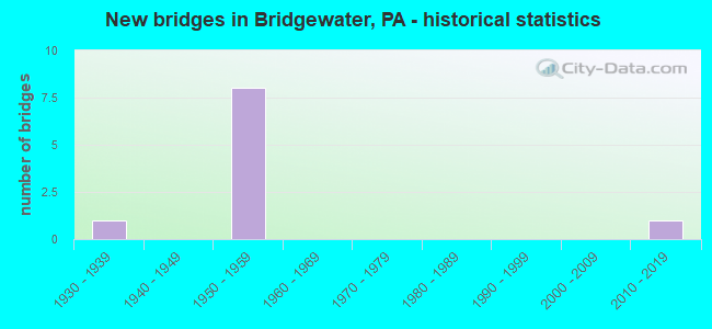
- New bridges - historical statistics
- 11930-1939
- 81950-1959
- 12010-2019

- Reconstructed bridges - Historical Statistics
- 11970-1979
- 11980-1989
- 01990-1999
- 22000-2009


- Bridge Condition - Deck
- 20.0%Very good
- 20.0%Good
- 40.0%Satisfactory
- 20.0%Fair

- Bridge Condition - Superstructure
- 20.0%Very good
- 40.0%Good
- 20.0%Satisfactory
- 20.0%Fair

- Bridge Condition - Substructure
- 20.0%Very good
- 40.0%Good
- 20.0%Satisfactory
- 20.0%Fair

- Bridge Condition - Channel
- 50.0%Good
- 50.0%Satisfactory
Find on map >> Show street view
Structure Number: 3489, Location: BRIDGEWATER O/SR 4042 (Lat: 40.699100, Lng: -80.292597), Route carried "on" structure: State highway 51, Year Built: 1958, Year Reconstructed: 2011, Status: Open, Structure Length: 3.87m (12.70ft), Average Daily Traffic: 23,785 (year 2021), Truck Traffic: 6%, Average Future Daily Traffic: 26,775 (year 2032), Design Load: HS 20, Features Intersected: SR 4042 (MARKET ST), Facility Carried by Structure: Constitution Blvd.
Minimum Vertical Clearance: 30+ m (98+ ft), Kilometerpoint: 16.472, Lanes on structure: 4, Lanes under structure: 2, Base Highway Network: Yes, Owner: State Highway Agency, Approaching Roadway Width: 20.7m (67.9ft), Skew: 30 degrees, Material/Design: Steel continuous, Design/Construction: Stringer/Multi-beam, Number Of Spans In Main Unit: 3, Length of Maximum Span: 16.5m (54.1ft), Curb or Sidewalk Widths: Left: 0.2m (0.7ft), Right: 0.2m (0.7ft), Curb-To-Curb Width: 20.7m (67.9ft), Out-to-Out Width: 21.6m (70.9ft)
Condition: Deck: Satisfactory, Superstructure: Good, Substructure: Good, Operating Rating: 58.1 metric tons, Method Used To Determine Operating Rating: Load Factor (LF), Inventory Rating: 34.5 metric tons, Method Used To Determine Inventory Rating: Load Factor (LF), Structural Evaluation: Better than present minimum criteria, Deck Geometry: Superior to present desirable criteria, Underclear: Better than present minimum criteria, Approach Roadway Alignment: Equal to present desirable criteria, Length Of Structure Improvement: 3.90m (12.80ft), Designated Inspection Frequency: Every 24 months, Inspection Date: August 2021, Deck Structure Type: Concrete Cast-file-Place, Wearing Surface/Protective System: Wearing Surface: Latex Concrete, Deck Protection: Epoxy Coated Reinforcing
Find on map >> Show street view
Structure Number: 3491, Location: 1 MI. NORTH OF SR 0068 (Lat: 40.709917, Lng: -80.300806), Route carried "on" structure: State highway 51, Year Built: 1957, Year Reconstructed: 1992, Status: Open, Structure Length: 4.18m (13.71ft), Average Daily Traffic: 9,586 (year 2020), Truck Traffic: 7%, Average Future Daily Traffic: 14,594 (year 2032), Design Load: HS 20, Features Intersected: SR 4016, SHARON RD., Facility Carried by Structure: PENNSYLVANIA AVE
Minimum Vertical Clearance: 30+ m (98+ ft), Kilometerpoint: 18.268, Lanes on structure: 4, Lanes under structure: 2, Base Highway Network: Yes, Owner: State Highway Agency, Approaching Roadway Width: 20.7m (67.9ft), Skew: 30 degrees, Material/Design: Steel continuous, Design/Construction: Stringer/Multi-beam, Number Of Spans In Main Unit: 3, Length of Maximum Span: 16.2m (53.1ft), Curb or Sidewalk Widths: Left: 0.2m (0.7ft), Right: 0.2m (0.7ft), Curb-To-Curb Width: 20.8m (68.2ft), Out-to-Out Width: 21.9m (71.9ft)
Condition: Deck: Good, Superstructure: Satisfactory, Substructure: Satisfactory, Operating Rating: 68.9 metric tons, Method Used To Determine Operating Rating: Load Factor (LF), Inventory Rating: 40.8 metric tons, Method Used To Determine Inventory Rating: Load Factor (LF), Structural Evaluation: Equal to present minimum criteria, Deck Geometry: Superior to present desirable criteria, Underclear: Somewhat better than minimum adequacy, Approach Roadway Alignment: Equal to present desirable criteria, Length Of Structure Improvement: 4.20m (13.78ft), Designated Inspection Frequency: Every 24 months, Inspection Date: August 2021, Deck Structure Type: Concrete Cast-file-Place, Wearing Surface/Protective System: Wearing Surface: Monolithic Concrete, Deck Protection: Epoxy Coated Reinforcing
Find on map >> Show street view
Structure Number: 3783, Location: OLD ROCHESTER-BRIDGEWATER (Lat: 40.701350, Lng: -80.291208), Route carried "on" structure: State highway , Year Built: 1933, Year Reconstructed: 1977, Status: Open, Structure Length: 19.75m (64.80ft), Average Daily Traffic: 2,786 (year 2020), Truck Traffic: 3%, Average Future Daily Traffic: 7,563 (year 2032), Design Load: HS 20, Features Intersected: N & S RR BEAVER RIVER, Facility Carried by Structure: SR 4042
Minimum Vertical Clearance: 4.78m (15.68ft), Kilometerpoint: 0.504, Lanes on structure: 2, Lanes under structure: 2, Owner: State Highway Agency, Approaching Roadway Width: 9.8m (32.2ft), Navigation Control: Yes ( Vertical Clearance: 11.0m (36.1ft), Horizontal Clearance: 106.7m (350.1ft)), Material/Design: Steel, Design/Construction: Truss - Thru, Number Of Spans In Main Unit: 3, Length of Maximum Span: 110.6m (362.9ft), Curb or Sidewalk Widths: Left: 1.5m (4.9ft), Right: 1.5m (4.9ft), Curb-To-Curb Width: 9.9m (32.5ft), Out-to-Out Width: 10.5m (34.4ft)
Condition: Deck: Fair, Superstructure: Fair, Substructure: Fair, Channel: Satisfactory, Operating Rating: 51.7 metric tons, Method Used To Determine Operating Rating: Load Factor (LF), Inventory Rating: 30.8 metric tons, Method Used To Determine Inventory Rating: Load Factor (LF), Structural Evaluation: Somewhat better than minimum adequacy, Deck Geometry: Meets minimum limits, Underclear: High priority of corrective action, Waterway Adequacy: Superior to present desirable criteria, Approach Roadway Alignment: Equal to present desirable criteria, Length Of Structure Improvement: 19.80m (64.96ft), Designated Inspection Frequency: Every 24 months, Critical Feature Inspection Frequency: Every 24 months, Underwater Inspection Frequency: Every 60 months, Inspection Date: November 2020, Critical Feature Inspection Date: November 2020, Underwater Inspection Date: August 2020, Bridge Improvement Cost: $156,000, Roadway Improvement Cost: $458,000, Total Project Cost: $2,101,000, Deck Structure Type: Concrete Cast-file-Place, Wearing Surface/Protective System: Wearing Surface: Monolithic Concrete, Deck Protection: Epoxy Coated Reinforcing
Find on map >> Show street view
Structure Number: 3926, Location: SR 68/51 INTERCHANGE (Lat: 40.700000, Lng: -80.300000), Route carried "on" structure: Ramp State highway , Year Built: 1955, Year Reconstructed: 2011, Status: Open, Structure Length: 3.05m (10.01ft), Average Daily Traffic: 7,296 (year 2022), Truck Traffic: 7%, Average Future Daily Traffic: 19,796 (year 2031), Design Load: HS 20, Features Intersected: SR 0051, Facility Carried by Structure: RAMP AD
Minimum Vertical Clearance: 30+ m (98+ ft), Kilometerpoint: 0.000, Lanes on structure: 2, Lanes under structure: 8, Base Highway Network: Yes, Owner: State Highway Agency, Approaching Roadway Width: 13.1m (43.0ft), Skew: 3 degrees, Material/Design: Steel, Design/Construction: Stringer/Multi-beam, Number Of Spans In Main Unit: 1, Length of Maximum Span: 29.3m (96.1ft), Curb or Sidewalk Widths: Left: 0.2m (0.7ft), Right: 1.5m (4.9ft), Curb-To-Curb Width: 14.5m (47.6ft), Out-to-Out Width: 17.1m (56.1ft)
Condition: Deck: Satisfactory, Superstructure: Good, Substructure: Good, Operating Rating: 78.9 metric tons, Method Used To Determine Operating Rating: Load Factor (LF), Inventory Rating: 45.4 metric tons, Method Used To Determine Inventory Rating: Load Factor (LF), Structural Evaluation: Better than present minimum criteria, Deck Geometry: Superior to present desirable criteria, Underclear: Equal to present minimum criteria, Approach Roadway Alignment: Better than present minimum criteria, Designated Inspection Frequency: Every 24 months, Inspection Date: August 2021, Deck Structure Type: Concrete Cast-file-Place, Wearing Surface/Protective System: Wearing Surface: Monolithic Concrete, Deck Protection: Epoxy Coated Reinforcing
Find on map >> Show street view
Structure Number: 48978, Location: 1 mi SE Fallston Br (Lat: 40.714906, Lng: -80.301442), Route carried "on" structure: County highway , Year Built: 2014, Status: Open, Structure Length: 18.29m (60.01ft), Average Daily Traffic: 10,220 (year 2019), Truck Traffic: 10%, Average Future Daily Traffic: 11,338 (year 2041), Design Load: HL 93, Features Intersected: Beaver River, Facility Carried by Structure: Vets Mem Br
Minimum Vertical Clearance: 30+ m (98+ ft), Kilometerpoint: 0.000, Lanes on structure: 3, Owner: County Highway Agency, Approaching Roadway Width: 15.8m (51.8ft), Navigation Control: Yes ( Vertical Clearance: 6.7m (22.0ft), Horizontal Clearance: 61.0m (200.1ft)), Material/Design: Steel continuous, Design/Construction: Stringer/Multi-beam, Number Of Spans In Main Unit: 3, Length of Maximum Span: 76.2m (250.0ft), Curb or Sidewalk Widths: Left: 0.2m (0.7ft), Right: 3.3m (10.8ft), Curb-To-Curb Width: 15.8m (51.8ft), Out-to-Out Width: 20.3m (66.6ft)
Condition: Deck: Very good, Superstructure: Very good, Substructure: Very good, Channel: Good, Operating Rating: 56.7 metric tons, Method Used To Determine Operating Rating: Assigned ratings based on Load and Resistance Factor Design (LRFD) reported by rating factor (RF) using HL93 loadings, Inventory Rating: 40.8 metric tons, Method Used To Determine Inventory Rating: Assigned ratings based on Load and Resistance Factor Design (LRFD) reported by rating factor (RF) using HL93 loadings, Structural Evaluation: Equal to present desirable criteria, Deck Geometry: Better than present minimum criteria, Waterway Adequacy: Equal to present desirable criteria, Approach Roadway Alignment: Better than present minimum criteria, Designated Inspection Frequency: Every 24 months, Underwater Inspection Frequency: Every 60 months, Inspection Date: March 2021, Underwater Inspection Date: August 2020, Deck Structure Type: Concrete Cast-file-Place, Wearing Surface/Protective System: Wearing Surface: Monolithic Concrete, Deck Protection: Epoxy Coated Reinforcing
Find on map >> Show street view
Structure Number: 3445, Location: SR 18 NB O/ 8041 RAMP A (Lat: 40.709444, Lng: -80.294553), Route carried "under" structure: Ramp State highway , Year Built: 1957, Structure Length: 0. m, Average Daily Traffic: 2,099 (year 2022), Truck Traffic: 4%, Features Intersected: SR 18 NB O/ 8041 RAMP A, Facility Carried by Structure: FRANKFORT RD
Minimum Vertical Clearance: 4.32m (14.17ft), Kilometerpoint: 0.000, Lanes on structure: 2, Lanes under structure: 1, Material/Design: Steel continuous, Design/Construction: Stringer/Multi-beam, Length of Maximum Span: 23.8m (78.1ft)
Find on map >> Show street view
Structure Number: 3489, Location: BRIDGEWATER O/SR 4042 (Lat: 40.699100, Lng: -80.292597), Route carried "under" structure: State highway , Year Built: 1958, Structure Length: 0. m, Average Daily Traffic: 2,482 (year 2022), Truck Traffic: 8%, Features Intersected: SR 4042 (MARKET ST), Facility Carried by Structure: Constitution Blvd.
Minimum Vertical Clearance: 5.79m (19.00ft), Kilometerpoint: 0.000, Lanes on structure: 4, Lanes under structure: 2, Material/Design: Steel continuous, Design/Construction: Stringer/Multi-beam, Length of Maximum Span: 16.5m (54.1ft)
Find on map >> Show street view
Structure Number: 3491, Location: 1 MI. NORTH OF SR 0068 (Lat: 40.709917, Lng: -80.300806), Route carried "under" structure: State highway , Year Built: 1957, Structure Length: 0. m, Average Daily Traffic: 2,595 (year 2021), Truck Traffic: 3%, Features Intersected: SR 4016, SHARON RD., Facility Carried by Structure: PENNSYLVANIA AVE
Minimum Vertical Clearance: 4.47m (14.67ft), Kilometerpoint: 1.968, Lanes on structure: 4, Lanes under structure: 2, Material/Design: Steel continuous, Design/Construction: Stringer/Multi-beam, Length of Maximum Span: 16.2m (53.1ft)
Find on map >> Show street view
Structure Number: 3926, Location: SR 68/51 INTERCHANGE (Lat: 40.700000, Lng: -80.300000), Route carried "under" structure: State highway 51, Year Built: 1955, Structure Length: 0. m, Average Daily Traffic: 4,341 (year 2022), Truck Traffic: 7%, Features Intersected: SR 0051, Facility Carried by Structure: RAMP AD
Minimum Vertical Clearance: 4.67m (15.32ft), Kilometerpoint: 16.472, Lanes on structure: 2, Lanes under structure: 4, Material/Design: Steel, Design/Construction: Stringer/Multi-beam, Length of Maximum Span: 29.3m (96.1ft)
Find on map >> Show street view
Structure Number: 3926, Location: SR 68/51 INTERCHANGE (Lat: 40.700000, Lng: -80.300000), Route carried "under" structure: State highway 51, Year Built: 1955, Structure Length: 0. m, Average Daily Traffic: 3,574 (year 2022), Truck Traffic: 7%, Features Intersected: SR 0051, Facility Carried by Structure: RAMP AD
Minimum Vertical Clearance: 4.67m (15.32ft), Kilometerpoint: 16.456, Lanes on structure: 2, Lanes under structure: 4, Material/Design: Steel, Design/Construction: Stringer/Multi-beam, Length of Maximum Span: 29.3m (96.1ft)