Bridge Statistics for Brimfield, Illinois (IL)
Condition, Traffic, Stress, Structural Evaluation, Project Costs
- National Bridge Inventory (NBI) Statistics
- 29Number of bridges
- 253ft / 77.0mTotal length
- $36,000Total costs
- 90,205Total average daily traffic
- 20,630Total average daily truck traffic
- National Bridge Inventory (NBI) Registered Bridges for Brimfield
- No street view available for this location
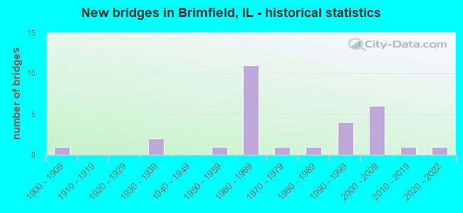
- New bridges - historical statistics
- 11900-1909
- 21930-1939
- 11950-1959
- 111960-1969
- 11970-1979
- 11980-1989
- 41990-1999
- 62000-2009
- 12010-2019
- 12020-2022

- Reconstructed bridges - Historical Statistics
- 21980-1989
- 01990-1999
- 02000-2009
- 02010-2019
- 12020-2022


- Bridge Condition - Deck
- 12.5%Excellent
- 12.5%Very good
- 18.8%Good
- 18.8%Satisfactory
- 6.3%Fair
- 6.3%Poor
- 25.0%Serious

- Bridge Condition - Superstructure
- 12.5%Excellent
- 18.8%Very good
- 18.8%Good
- 12.5%Satisfactory
- 31.3%Poor
- 6.3%Serious

- Bridge Condition - Substructure
- 6.3%Excellent
- 18.8%Very good
- 43.8%Good
- 6.3%Satisfactory
- 25.0%Fair

- Bridge Condition - Channel
- 5.9%Very good
- 11.8%Good
- 29.4%Satisfactory
- 35.3%Fair
- 11.8%Poor
- 5.9%Serious

- Bridge Condition - Culverts
- 42.9%Good
- 42.9%Satisfactory
- 14.3%Poor
Find on map >> Show street view
Structure Number: 720042, Location: AT OAK HILL (Lat: 40.786503, Lng: -89.864811), Route carried "on" structure: State highway 8, Year Built: 1935, Year Reconstructed: 1994, Status: Open, Structure Length: 4.21m (13.81ft), Average Daily Traffic: 1,850 (year 2021), Truck Traffic: 6%, Average Future Daily Traffic: 1,859 (year 2032), Design Load: HS 20, Features Intersected: BN RR (094069E)
Minimum Vertical Clearance: 30+ m (98+ ft), Kilometerpoint: 25.974, Lanes on structure: 2, Owner: State Highway Agency, Approaching Roadway Width: 10.4m (34.1ft), Material/Design: Steel continuous, Design/Construction: Stringer/Multi-beam, Number Of Spans In Main Unit: 3, Length of Maximum Span: 14.1m (46.3ft), Curb-To-Curb Width: 9.8m (32.2ft), Out-to-Out Width: 10.7m (35.1ft)
Condition: Deck: Satisfactory, Superstructure: Satisfactory, Substructure: Satisfactory, Operating Rating: 71.9 metric tons, Method Used To Determine Operating Rating: Load Factor (LF) rating reported by rating factor (RF) method using MS18 loading, Inventory Rating: 43.4 metric tons, Method Used To Determine Inventory Rating: Load Factor (LF) rating reported by rating factor (RF) method using MS18 loading, Structural Evaluation: Equal to present minimum criteria, Deck Geometry: Somewhat better than minimum adequacy, Underclear: Equal to present minimum criteria, Approach Roadway Alignment: Equal to present minimum criteria, Designated Inspection Frequency: Every 24 months, Inspection Date: December 2019, Deck Structure Type: Concrete Cast-file-Place, Wearing Surface/Protective System: Deck Protection: Epoxy Coated Reinforcing
Find on map >> Show street view
Structure Number: 720043, Location: .5 MI E OF OAKHILL (Lat: 40.782378, Lng: -89.859006), Route carried "on" structure: State highway 8, Year Built: 1932, Year Reconstructed: 1980, Status: Temporarily open, Structure Length: 4.36m (14.30ft), Average Daily Traffic: 1,850 (year 2021), Truck Traffic: 6%, Average Future Daily Traffic: 1,859 (year 2032), Design Load: HS 20, Features Intersected: W FORK KICKAPOO CR
Minimum Vertical Clearance: 30+ m (98+ ft), Kilometerpoint: 26.618, Lanes on structure: 2, Owner: State Highway Agency, Approaching Roadway Width: 10.4m (34.1ft), Material/Design: Prestressed concrete, Design/Construction: Box Beam or Girders - Multiple, Number Of Spans In Main Unit: 2, Length of Maximum Span: 21.9m (71.9ft), Curb-To-Curb Width: 9.9m (32.5ft), Out-to-Out Width: 10.2m (33.5ft)
Condition: Deck: Poor, Superstructure: Poor, Substructure: Fair, Channel: Fair, Operating Rating: 17.5 metric tons, Method Used To Determine Operating Rating: Load Factor (LF) rating reported by rating factor (RF) method using MS18 loading, Inventory Rating: 10.4 metric tons, Method Used To Determine Inventory Rating: Load Factor (LF) rating reported by rating factor (RF) method using MS18 loading, Structural Evaluation: High priority of corrective action, Deck Geometry: Somewhat better than minimum adequacy, Waterway Adequacy: Equal to present desirable criteria, Approach Roadway Alignment: Equal to present minimum criteria, Designated Inspection Frequency: Every 12 months, Inspection Date: April 2021, Deck Structure Type: Concrete Precast Panels, Wearing Surface/Protective System: Wearing Surface: Bituminous, Membrane: Built-up
Find on map >> Show street view
Structure Number: 720069, Location: 4 MI W OF KICKAPOO (Lat: 40.808092, Lng: -89.832467), Route carried "on" structure: County highway , Year Built: 1967, Status: Open, Structure Length: 8.81m (28.90ft), Average Daily Traffic: 150 (year 2017), Truck Traffic: 13%, Average Future Daily Traffic: 133 (year 2032), Design Load: HS 15, Features Intersected: I-74, Facility Carried by Structure: TR 124 (1000 Dolla
Minimum Vertical Clearance: 30+ m (98+ ft), Kilometerpoint: 3.959, Lanes on structure: 2, Lanes under structure: 4, Owner: State Highway Agency, Approaching Roadway Width: 11.0m (36.1ft), Skew: 3 degrees, Material/Design: Steel continuous, Design/Construction: Stringer/Multi-beam, Number Of Spans In Main Unit: 4, Length of Maximum Span: 27.1m (88.9ft), Curb-To-Curb Width: 8.1m (26.6ft), Out-to-Out Width: 9.1m (29.9ft)
Condition: Deck: Fair, Superstructure: Poor, Substructure: Good, Operating Rating: 48.0 metric tons, Method Used To Determine Operating Rating: Load Factor (LF) rating reported by rating factor (RF) method using MS18 loading, Inventory Rating: 28.8 metric tons, Method Used To Determine Inventory Rating: Load Factor (LF) rating reported by rating factor (RF) method using MS18 loading, Structural Evaluation: Meets minimum limits, Deck Geometry: Somewhat better than minimum adequacy, Underclear: Meets minimum limits, Approach Roadway Alignment: Equal to present minimum criteria, Designated Inspection Frequency: Every 12 months, Inspection Date: November 2021, Deck Structure Type: Concrete Cast-file-Place, Wearing Surface/Protective System: Wearing Surface: Bituminous, Membrane: Built-up
Find on map >> Show street view
Structure Number: 720073, Location: S JCT US150-ILL78 (Lat: 40.851097, Lng: -89.927561), Route carried "on" structure: Other road , Year Built: 1968, Year Reconstructed: 2020, Status: Open, Structure Length: 6.87m (22.54ft), Average Daily Traffic: 2,000 (year 2017), Truck Traffic: 11%, Average Future Daily Traffic: 1,965 (year 2032), Design Load: HS 25 or greater, Features Intersected: I-74, Facility Carried by Structure: BELL SCHOOL RD
Minimum Vertical Clearance: 30+ m (98+ ft), Kilometerpoint: 0.837, Lanes on structure: 2, Lanes under structure: 4, Base Highway Network: Yes (Inventory Route: 20022020, Subroute: 10), Owner: State Highway Agency, Approaching Roadway Width: 14.6m (47.9ft), Skew: 31 degrees, Material/Design: Steel continuous, Design/Construction: Stringer/Multi-beam, Number Of Spans In Main Unit: 4, Length of Maximum Span: 22.1m (72.5ft), Curb-To-Curb Width: 11.3m (37.1ft), Out-to-Out Width: 17.7m (58.1ft)
Condition: Deck: Excellent, Superstructure: Excellent, Substructure: Good, Operating Rating: 67.4 metric tons, Method Used To Determine Operating Rating: Load and Resistance Factor Rating (LRFR) rating reported by rating factor(RF) method using HL-93 loadings, Inventory Rating: 51.8 metric tons, Method Used To Determine Inventory Rating: Load and Resistance Factor Rating (LRFR) rating reported by rating factor(RF) method using HL-93 loadings, Structural Evaluation: Better than present minimum criteria, Deck Geometry: Equal to present minimum criteria, Underclear: Meets minimum limits, Approach Roadway Alignment: Equal to present desirable criteria, Designated Inspection Frequency: Every 24 months, Inspection Date: October 2020, Deck Structure Type: Concrete Cast-file-Place, Wearing Surface/Protective System: Deck Protection: Epoxy Coated Reinforcing
Find on map >> Show street view
Structure Number: 720074, Location: S OF BRIMFIELD (Lat: 40.834911, Lng: -89.889561), Route carried "on" structure: Interstate 74, Year Built: 1968, Status: Open, Structure Length: 8.20m (26.90ft), Average Daily Traffic: 8,600 (year 2021), Truck Traffic: 30%, Average Future Daily Traffic: 8,390 (year 2032), Design Load: HS 20+Mod, Features Intersected: CH R23
Minimum Vertical Clearance: 30+ m (98+ ft), Kilometerpoint: 121.052, Lanes on structure: 2, Lanes under structure: 2, Base Highway Network: Yes, Owner: State Highway Agency, Approaching Roadway Width: 11.0m (36.1ft), Material/Design: Steel continuous, Design/Construction: Stringer/Multi-beam, Number Of Spans In Main Unit: 5, Length of Maximum Span: 18.0m (59.1ft), Curb-To-Curb Width: 9.9m (32.5ft), Out-to-Out Width: 11.0m (36.1ft)
Condition: Deck: Serious, Superstructure: Poor, Substructure: Fair, Operating Rating: 55.7 metric tons, Method Used To Determine Operating Rating: Load Factor (LF) rating reported by rating factor (RF) method using MS18 loading, Inventory Rating: 33.4 metric tons, Method Used To Determine Inventory Rating: Load Factor (LF) rating reported by rating factor (RF) method using MS18 loading, Structural Evaluation: Meets minimum limits, Deck Geometry: Meets minimum limits, Underclear: Superior to present desirable criteria, Approach Roadway Alignment: Equal to present desirable criteria, Designated Inspection Frequency: Every 12 months, Inspection Date: January 2021, Deck Structure Type: Concrete Cast-file-Place, Wearing Surface/Protective System: Wearing Surface: Other, Membrane: Built-up
Find on map >> Show street view
Structure Number: 720075, Location: S OF BRIMFIELD (Lat: 40.834850, Lng: -89.889403), Route carried "on" structure: Interstate 74, Year Built: 1968, Status: Open, Structure Length: 8.20m (26.90ft), Average Daily Traffic: 8,600 (year 2021), Truck Traffic: 30%, Average Future Daily Traffic: 8,390 (year 2032), Design Load: HS 20+Mod, Features Intersected: CH23R
Minimum Vertical Clearance: 30+ m (98+ ft), Kilometerpoint: 121.068, Lanes on structure: 2, Lanes under structure: 2, Base Highway Network: Yes, Owner: State Highway Agency, Approaching Roadway Width: 11.0m (36.1ft), Material/Design: Steel continuous, Design/Construction: Stringer/Multi-beam, Number Of Spans In Main Unit: 5, Length of Maximum Span: 18.0m (59.1ft), Curb-To-Curb Width: 9.9m (32.5ft), Out-to-Out Width: 11.0m (36.1ft)
Condition: Deck: Serious, Superstructure: Poor, Substructure: Fair, Operating Rating: 55.7 metric tons, Method Used To Determine Operating Rating: Load Factor (LF) rating reported by rating factor (RF) method using MS18 loading, Inventory Rating: 33.4 metric tons, Method Used To Determine Inventory Rating: Load Factor (LF) rating reported by rating factor (RF) method using MS18 loading, Structural Evaluation: Meets minimum limits, Deck Geometry: Meets minimum limits, Underclear: Superior to present desirable criteria, Approach Roadway Alignment: Equal to present desirable criteria, Designated Inspection Frequency: Every 12 months, Inspection Date: January 2021, Deck Structure Type: Concrete Cast-file-Place, Wearing Surface/Protective System: Wearing Surface: Other, Membrane: Built-up
Find on map >> Show street view
Structure Number: 720076, Location: BRIMFIELD INTERCH. (Lat: 40.827669, Lng: -89.870439), Route carried "on" structure: County highway , Year Built: 1968, Status: Open, Structure Length: 7.81m (25.62ft), Average Daily Traffic: 2,250 (year 2017), Truck Traffic: 8%, Average Future Daily Traffic: 2,177 (year 2032), Design Load: HS 20, Features Intersected: I-74, Facility Carried by Structure: MAHER RD-CH 25R
Minimum Vertical Clearance: 30+ m (98+ ft), Kilometerpoint: 0.322, Lanes on structure: 2, Lanes under structure: 4, Base Highway Network: Yes, Owner: State Highway Agency, Approaching Roadway Width: 7.3m (24.0ft), Skew: 32 degrees, Material/Design: Steel continuous, Design/Construction: Stringer/Multi-beam, Number Of Spans In Main Unit: 4, Length of Maximum Span: 23.9m (78.4ft), Curb-To-Curb Width: 11.4m (37.4ft), Out-to-Out Width: 17.7m (58.1ft)
Condition: Deck: Serious, Superstructure: Poor, Substructure: Fair, Operating Rating: 52.2 metric tons, Method Used To Determine Operating Rating: Load Factor (LF) rating reported by rating factor (RF) method using MS18 loading, Inventory Rating: 26.9 metric tons, Method Used To Determine Inventory Rating: Load Factor (LF) rating reported by rating factor (RF) method using MS18 loading, Structural Evaluation: Meets minimum limits, Deck Geometry: Somewhat better than minimum adequacy, Underclear: Meets minimum limits, Approach Roadway Alignment: Equal to present minimum criteria, Designated Inspection Frequency: Every 12 months, Inspection Date: October 2021, Deck Structure Type: Concrete Cast-file-Place, Wearing Surface/Protective System: Wearing Surface: Bituminous, Membrane: Built-up
Find on map >> Show street view
Structure Number: 722017, Location: 1 MI W OF BRIMFIELD (Lat: 40.844031, Lng: -89.901394), Route carried "on" structure: US 150, Year Built: 1992, Status: Open, Structure Length: 0.72m (2.36ft), Average Daily Traffic: 2,150 (year 2021), Truck Traffic: 6%, Average Future Daily Traffic: 1,221 (year 2032), Design Load: HS 20, Features Intersected: WALNUT CREEK
Minimum Vertical Clearance: 30+ m (98+ ft), Kilometerpoint: 109.207, Lanes on structure: 2, Base Highway Network: Yes, Owner: State Highway Agency, Approaching Roadway Width: 9.1m (29.9ft), Material/Design: Prestressed concrete, Design/Construction: Culvert, Number Of Spans In Main Unit: 2, Length of Maximum Span: 3.0m (9.8ft)
Condition: Channel: Satisfactory, Culverts: Satisfactory, Operating Rating: 44.1 metric tons, Method Used To Determine Operating Rating: Load Factor (LF) rating reported by rating factor (RF) method using MS18 loading, Inventory Rating: 32.4 metric tons, Method Used To Determine Inventory Rating: Load Factor (LF) rating reported by rating factor (RF) method using MS18 loading, Structural Evaluation: Equal to present minimum criteria, Waterway Adequacy: Equal to present desirable criteria, Approach Roadway Alignment: Equal to present desirable criteria, Designated Inspection Frequency: Every 24 months, Inspection Date: Febuary 2021
Find on map >> Show street view
Structure Number: 722033, Location: 2 MI S OF LAURA (Lat: 40.892308, Lng: -89.927219), Route carried "on" structure: US 150, Year Built: 2002, Status: Open, Structure Length: 0.87m (2.85ft), Average Daily Traffic: 3,750 (year 2021), Truck Traffic: 10%, Average Future Daily Traffic: 3,717 (year 2032), Design Load: HS 20, Features Intersected: FRENCH CR
Minimum Vertical Clearance: 30+ m (98+ ft), Kilometerpoint: 102.577, Lanes on structure: 2, Base Highway Network: Yes, Owner: State Highway Agency, Approaching Roadway Width: 11.0m (36.1ft), Skew: 1 degrees, Material/Design: Concrete, Design/Construction: Culvert, Number Of Spans In Main Unit: 2, Length of Maximum Span: 4.0m (13.1ft)
Condition: Channel: Fair, Culverts: Satisfactory, Operating Rating: 44.1 metric tons, Method Used To Determine Operating Rating: Load Factor (LF) rating reported by rating factor (RF) method using MS18 loading, Inventory Rating: 32.4 metric tons, Method Used To Determine Inventory Rating: Load Factor (LF) rating reported by rating factor (RF) method using MS18 loading, Structural Evaluation: Equal to present minimum criteria, Waterway Adequacy: Superior to present desirable criteria, Approach Roadway Alignment: Equal to present desirable criteria, Designated Inspection Frequency: Every 24 months, Inspection Date: May 2021
Find on map >> Show street view
Structure Number: 72308, Location: SE 18-JUBILEE TWP (Lat: 40.843131, Lng: -89.855650), Route carried "on" structure: County highway , Year Built: 1968, Status: Open, Structure Length: 0.71m (2.33ft), Average Daily Traffic: 550 (year 2017), Truck Traffic: 6%, Average Future Daily Traffic: 584 (year 2032), Design Load: HS 15, Features Intersected: BR KICKAPOO CREEK, Facility Carried by Structure: BRIMFIELD-JUBILEE
Minimum Vertical Clearance: 30+ m (98+ ft), Kilometerpoint: 1.207, Lanes on structure: 2, Owner: County Highway Agency, Approaching Roadway Width: 9.1m (29.9ft), Skew: 1 degrees, Material/Design: Concrete, Design/Construction: Culvert, Number Of Spans In Main Unit: 2, Length of Maximum Span: 3.0m (9.8ft)
Condition: Channel: Poor, Culverts: Good, Operating Rating: 92.3 metric tons, Method Used To Determine Operating Rating: Load Factor (LF) rating reported by rating factor (RF) method using MS18 loading, Inventory Rating: 55.4 metric tons, Method Used To Determine Inventory Rating: Load Factor (LF) rating reported by rating factor (RF) method using MS18 loading, Structural Evaluation: Better than present minimum criteria, Waterway Adequacy: Somewhat better than minimum adequacy, Approach Roadway Alignment: Better than present minimum criteria, Designated Inspection Frequency: Every 24 months, Inspection Date: September 2020
Find on map >> Show street view
Structure Number: 723098, Location: E1/2-6-JUBILEE (Lat: 40.879789, Lng: -89.854722), Route carried "on" structure: County highway , Year Built: 1950, Status: Open, Structure Length: 0.79m (2.59ft), Average Daily Traffic: 225 (year 2017), Truck Traffic: 4%, Average Future Daily Traffic: 186 (year 2032), Features Intersected: STREAM, Facility Carried by Structure: PARKS SCHOOL ROAD
Minimum Vertical Clearance: 30+ m (98+ ft), Kilometerpoint: 3.573, Lanes on structure: 2, Owner: County Highway Agency, Approaching Roadway Width: 9.8m (32.2ft), Material/Design: Steel, Design/Construction: Culvert, Number Of Spans In Main Unit: 2, Length of Maximum Span: 3.4m (11.2ft)
Condition: Channel: Satisfactory, Culverts: Satisfactory, Operating Rating: 40.5 metric tons, Method Used To Determine Operating Rating: Field evaluation and documented engineering judgment, Inventory Rating: 24.3 metric tons, Method Used To Determine Inventory Rating: Field evaluation and documented engineering judgment, Structural Evaluation: Equal to present minimum criteria, Waterway Adequacy: Equal to present minimum criteria, Approach Roadway Alignment: Equal to present minimum criteria, Designated Inspection Frequency: Every 24 months, Inspection Date: September 2020
Find on map >> Show street view
Structure Number: 723132, Location: S.CTR-35-BRIMFIELD (Lat: 40.802056, Lng: -89.898494), Route carried "on" structure: County highway , Year Built: 1994, Status: Open, Structure Length: 2.01m (6.59ft), Average Daily Traffic: 175 (year 2017), Truck Traffic: 11%, Average Future Daily Traffic: 133 (year 2032), Design Load: HS 20, Features Intersected: TIBER CREEK, Facility Carried by Structure: PULSIFER RD
Minimum Vertical Clearance: 30+ m (98+ ft), Kilometerpoint: 14.934, Lanes on structure: 2, Owner: County Highway Agency, Approaching Roadway Width: 11.0m (36.1ft), Skew: 3 degrees, Material/Design: Prestressed concrete, Design/Construction: Box Beam or Girders - Multiple, Number Of Spans In Main Unit: 1, Length of Maximum Span: 19.1m (62.7ft), Curb-To-Curb Width: 11.0m (36.1ft), Out-to-Out Width: 11.0m (36.1ft)
Condition: Deck: Serious, Superstructure: Serious, Substructure: Good, Channel: Good, Operating Rating: 40.2 metric tons, Method Used To Determine Operating Rating: Load Factor (LF) rating reported by rating factor (RF) method using MS18 loading, Inventory Rating: 23.3 metric tons, Method Used To Determine Inventory Rating: Load Factor (LF) rating reported by rating factor (RF) method using MS18 loading, Structural Evaluation: High priority of corrective action, Deck Geometry: Equal to present desirable criteria, Waterway Adequacy: Equal to present desirable criteria, Approach Roadway Alignment: Equal to present desirable criteria, Designated Inspection Frequency: Every 24 months, Inspection Date: September 2020, Deck Structure Type: Concrete Precast Panels, Wearing Surface/Protective System: Wearing Surface: Bituminous, Membrane: Built-up
Find on map >> Show street view
Structure Number: 723143, Location: SW 1/4-23-BRIMFIELD (Lat: 40.829083, Lng: -89.905369), Route carried "on" structure: County highway , Year Built: 2004, Status: Open, Structure Length: 2.41m (7.91ft), Average Daily Traffic: 450 (year 2017), Truck Traffic: 3%, Average Future Daily Traffic: 478 (year 2032), Design Load: HS 20, Features Intersected: WALNUT CREEK, Facility Carried by Structure: SHISSLER RD
Minimum Vertical Clearance: 30+ m (98+ ft), Kilometerpoint: 1.883, Lanes on structure: 2, Owner: County Highway Agency, Approaching Roadway Width: 6.4m (21.0ft), Skew: 2 degrees, Material/Design: Prestressed concrete, Design/Construction: Box Beam or Girders - Multiple, Number Of Spans In Main Unit: 1, Length of Maximum Span: 23.5m (77.1ft), Curb-To-Curb Width: 9.1m (29.9ft), Out-to-Out Width: 9.1m (29.9ft)
Condition: Deck: Very good, Superstructure: Very good, Substructure: Good, Channel: Fair, Operating Rating: 44.1 metric tons, Method Used To Determine Operating Rating: Assigned rating based on Load Factor Design (LFD) reported by rating factor (RF) using MS18 loading, Inventory Rating: 32.4 metric tons, Method Used To Determine Inventory Rating: Assigned rating based on Load Factor Design (LFD) reported by rating factor (RF) using MS18 loading, Structural Evaluation: Better than present minimum criteria, Deck Geometry: Equal to present minimum criteria, Waterway Adequacy: Equal to present desirable criteria, Approach Roadway Alignment: Equal to present desirable criteria, Designated Inspection Frequency: Every 48 months, Inspection Date: September 2019, Deck Structure Type: Concrete Precast Panels, Wearing Surface/Protective System: Wearing Surface: Bituminous, Membrane: Built-up
Find on map >> Show street view
Structure Number: 72315, Location: SW1/4-16-Jubilee (Lat: 40.843186, Lng: -89.827233), Route carried "on" structure: County highway , Year Built: 2014, Status: Open, Structure Length: 4.00m (13.12ft), Average Daily Traffic: 500 (year 2017), Truck Traffic: 4%, Average Future Daily Traffic: 425 (year 2032), Design Load: HS 25 or greater, Features Intersected: Branch Jubilee Creek, Facility Carried by Structure: CH D29
Minimum Vertical Clearance: 30+ m (98+ ft), Kilometerpoint: 3.589, Lanes on structure: 2, Owner: County Highway Agency, Approaching Roadway Width: 9.1m (29.9ft), Skew: 3 degrees, Material/Design: Steel, Design/Construction: Stringer/Multi-beam, Number Of Spans In Main Unit: 3, Length of Maximum Span: 15.4m (50.5ft), Curb-To-Curb Width: 8.5m (27.9ft), Out-to-Out Width: 9.5m (31.2ft)
Condition: Deck: Satisfactory, Superstructure: Very good, Substructure: Very good, Channel: Good, Operating Rating: 42.1 metric tons, Method Used To Determine Operating Rating: Assigned ratings based on Load and Resistance Factor Design (LRFD) reported by rating factor (RF) using HL93 loadings, Inventory Rating: 32.4 metric tons, Method Used To Determine Inventory Rating: Assigned ratings based on Load and Resistance Factor Design (LRFD) reported by rating factor (RF) using HL93 loadings, Structural Evaluation: Equal to present desirable criteria, Deck Geometry: Somewhat better than minimum adequacy, Waterway Adequacy: Equal to present desirable criteria, Approach Roadway Alignment: Equal to present minimum criteria, Designated Inspection Frequency: Every 48 months, Inspection Date: September 2020, Deck Structure Type: Concrete Cast-file-Place, Wearing Surface/Protective System: Deck Protection: Epoxy Coated Reinforcing
Find on map >> Show street view
Structure Number: 72316, Location: SE1/4-16-JUBILEE (Lat: 40.843056, Lng: -89.818000), Route carried "on" structure: County highway , Year Built: 2021, Status: Open, Structure Length: 3.88m (12.73ft), Average Daily Traffic: 525 (year 2017), Truck Traffic: 4%, Average Future Daily Traffic: 525 (year 2027), Design Load: HS 25 or greater, Features Intersected: JUBILEE CREEK, Facility Carried by Structure: BRIM.JUBILEE ROAD
Minimum Vertical Clearance: 30+ m (98+ ft), Kilometerpoint: 4.361, Lanes on structure: 2, Owner: County Highway Agency, Approaching Roadway Width: 9.1m (29.9ft), Material/Design: Steel, Design/Construction: Stringer/Multi-beam, Number Of Spans In Main Unit: 1, Length of Maximum Span: 37.8m (124.0ft), Curb-To-Curb Width: 9.0m (29.5ft), Out-to-Out Width: 10.0m (32.8ft)
Condition: Deck: Excellent, Superstructure: Excellent, Substructure: Excellent, Channel: Very good, Deck Geometry: Somewhat better than minimum adequacy, Waterway Adequacy: Superior to present desirable criteria, Approach Roadway Alignment: Better than present minimum criteria, Designated Inspection Frequency: Every 24 months, Inspection Date: October 2021, Deck Structure Type: Concrete Cast-file-Place, Wearing Surface/Protective System: Deck Protection: Epoxy Coated Reinforcing
Find on map >> Show street view
Structure Number: 724413, Location: NW1/4 35 T11NR5E (Lat: 40.898969, Lng: -89.907981), Route carried "on" structure: County highway , Year Built: 2000, Status: Open, Structure Length: 1.71m (5.61ft), Average Daily Traffic: 10 (year 2017), Average Future Daily Traffic: 11 (year 2032), Design Load: HS 20, Features Intersected: BR FRENCH CREEK, Facility Carried by Structure: WHITTAKER ROAD
Minimum Vertical Clearance: 30+ m (98+ ft), Kilometerpoint: 7.000, Lanes on structure: 2, Owner: Town or Township Highway Agency, Approaching Roadway Width: 4.3m (14.1ft), Skew: 1 degrees, Material/Design: Prestressed concrete, Design/Construction: Box Beam or Girders - Multiple, Number Of Spans In Main Unit: 1, Length of Maximum Span: 16.1m (52.8ft), Curb-To-Curb Width: 9.1m (29.9ft), Out-to-Out Width: 9.1m (29.9ft)
Condition: Deck: Good, Superstructure: Good, Substructure: Very good, Channel: Satisfactory, Operating Rating: 44.1 metric tons, Method Used To Determine Operating Rating: Assigned rating based on Load Factor Design (LFD) reported by rating factor (RF) using MS18 loading, Inventory Rating: 32.4 metric tons, Method Used To Determine Inventory Rating: Assigned rating based on Load Factor Design (LFD) reported by rating factor (RF) using MS18 loading, Structural Evaluation: Better than present minimum criteria, Deck Geometry: Better than present minimum criteria, Waterway Adequacy: Equal to present desirable criteria, Approach Roadway Alignment: Equal to present desirable criteria, Designated Inspection Frequency: Every 48 months, Inspection Date: September 2021, Deck Structure Type: Concrete Precast Panels, Wearing Surface/Protective System: Wearing Surface: Bituminous, Membrane: Built-up
Find on map >> Show street view
Structure Number: 724414, Location: SE QTR 26 MILLBROOK (Lat: 40.901661, Lng: -89.893317), Route carried "on" structure: County highway , Year Built: 2000, Status: Open, Structure Length: 1.71m (5.61ft), Average Daily Traffic: 50 (year 2017), Average Future Daily Traffic: 53 (year 2032), Design Load: HS 20, Features Intersected: FRENCH CR, Facility Carried by Structure: SCOTLAND PRAIRIE
Minimum Vertical Clearance: 30+ m (98+ ft), Kilometerpoint: 2.865, Lanes on structure: 2, Owner: Town or Township Highway Agency, Approaching Roadway Width: 4.3m (14.1ft), Material/Design: Prestressed concrete, Design/Construction: Box Beam or Girders - Multiple, Number Of Spans In Main Unit: 1, Length of Maximum Span: 16.1m (52.8ft), Curb-To-Curb Width: 9.1m (29.9ft), Out-to-Out Width: 9.1m (29.9ft)
Condition: Deck: Good, Superstructure: Good, Substructure: Good, Channel: Satisfactory, Operating Rating: 44.1 metric tons, Method Used To Determine Operating Rating: Assigned rating based on Load Factor Design (LFD) reported by rating factor (RF) using MS18 loading, Inventory Rating: 32.4 metric tons, Method Used To Determine Inventory Rating: Assigned rating based on Load Factor Design (LFD) reported by rating factor (RF) using MS18 loading, Structural Evaluation: Better than present minimum criteria, Deck Geometry: Better than present minimum criteria, Waterway Adequacy: Equal to present desirable criteria, Approach Roadway Alignment: Equal to present desirable criteria, Designated Inspection Frequency: Every 48 months, Inspection Date: September 2021, Deck Structure Type: Concrete Precast Panels, Wearing Surface/Protective System: Wearing Surface: Bituminous, Membrane: Built-up
Find on map >> Show street view
Structure Number: 724512, Location: SE-27-T10NR5E (Lat: 40.818919, Lng: -89.908514), Route carried "on" structure: County highway , Year Built: 1975, Status: Open, Structure Length: 0.98m (3.22ft), Average Daily Traffic: 10 (year 2017), Average Future Daily Traffic: 11 (year 2032), Design Load: HS 20, Features Intersected: WALNUT CREEK, Facility Carried by Structure: GRANGE RD
Minimum Vertical Clearance: 30+ m (98+ ft), Kilometerpoint: 1.127, Lanes on structure: 2, Owner: Town or Township Highway Agency, Approaching Roadway Width: 9.1m (29.9ft), Skew: 3 degrees, Material/Design: Concrete, Design/Construction: Culvert, Number Of Spans In Main Unit: 2, Length of Maximum Span: 4.4m (14.4ft)
Condition: Channel: Serious, Culverts: Good, Operating Rating: 89.1 metric tons, Method Used To Determine Operating Rating: Load Factor (LF) rating reported by rating factor (RF) method using MS18 loading, Inventory Rating: 56.1 metric tons, Method Used To Determine Inventory Rating: Load Factor (LF) rating reported by rating factor (RF) method using MS18 loading, Structural Evaluation: Better than present minimum criteria, Waterway Adequacy: Better than present minimum criteria, Approach Roadway Alignment: Better than present minimum criteria, Designated Inspection Frequency: Every 48 months, Inspection Date: September 2020
Find on map >> Show street view
Structure Number: 724514, Location: S.CTR-14-T10NR5E (Lat: 40.846669, Lng: -89.898600), Route carried "on" structure: County highway , Year Built: 1982, Status: Open, Structure Length: 0.64m (2.10ft), Average Daily Traffic: 10 (year 2017), Average Future Daily Traffic: 11 (year 2032), Design Load: HS 20, Features Intersected: BR OF WALNUT CREEK, Facility Carried by Structure: CEMETERY ROAD-TR
Minimum Vertical Clearance: 30+ m (98+ ft), Kilometerpoint: 1.304, Lanes on structure: 2, Owner: Town or Township Highway Agency, Approaching Roadway Width: 4.6m (15.1ft), Material/Design: Steel, Design/Construction: Culvert, Number Of Spans In Main Unit: 2, Length of Maximum Span: 2.7m (8.9ft)
Condition: Channel: Fair, Culverts: Poor, Operating Rating: 66.4 metric tons, Method Used To Determine Operating Rating: Load Factor (LF) rating reported by rating factor (RF) method using MS18 loading, Inventory Rating: 39.9 metric tons, Method Used To Determine Inventory Rating: Load Factor (LF) rating reported by rating factor (RF) method using MS18 loading, Structural Evaluation: Meets minimum limits, Waterway Adequacy: Equal to present minimum criteria, Approach Roadway Alignment: Equal to present minimum criteria, Length Of Structure Improvement: 0.64m (2.10ft), Designated Inspection Frequency: Every 24 months, Inspection Date: September 2020, Bridge Improvement Cost: $24,000, Roadway Improvement Cost: $2,000, Total Project Cost: $36,000
Find on map >> Show street view
Structure Number: 724516, Location: CTR-36-T10NR5E (Lat: 40.806919, Lng: -89.882278), Route carried "on" structure: County highway , Year Built: 1994, Status: Open, Structure Length: 1.58m (5.18ft), Average Daily Traffic: 25 (year 2017), Average Future Daily Traffic: 27 (year 2032), Design Load: HS 20, Features Intersected: TIBER CREEK, Facility Carried by Structure: CAHILL ROAD
Minimum Vertical Clearance: 30+ m (98+ ft), Kilometerpoint: 0.660, Lanes on structure: 2, Owner: Town or Township Highway Agency, Approaching Roadway Width: 6.7m (22.0ft), Material/Design: Prestressed concrete, Design/Construction: Box Beam or Girders - Multiple, Number Of Spans In Main Unit: 1, Length of Maximum Span: 15.2m (49.9ft), Curb-To-Curb Width: 9.1m (29.9ft), Out-to-Out Width: 9.1m (29.9ft)
Condition: Deck: Satisfactory, Superstructure: Satisfactory, Substructure: Good, Channel: Poor, Operating Rating: 44.1 metric tons, Method Used To Determine Operating Rating: Assigned rating based on Load Factor Design (LFD) reported by rating factor (RF) using MS18 loading, Inventory Rating: 32.4 metric tons, Method Used To Determine Inventory Rating: Assigned rating based on Load Factor Design (LFD) reported by rating factor (RF) using MS18 loading, Structural Evaluation: Equal to present minimum criteria, Deck Geometry: Better than present minimum criteria, Waterway Adequacy: Equal to present desirable criteria, Approach Roadway Alignment: Better than present minimum criteria, Designated Inspection Frequency: Every 24 months, Inspection Date: September 2021, Deck Structure Type: Concrete Precast Panels, Wearing Surface/Protective System: Wearing Surface: Bituminous, Membrane: Built-up
Find on map >> Show street view
Structure Number: 724518, Location: NE-34-T10NR5E (Lat: 40.814547, Lng: -89.912025), Route carried "on" structure: County highway , Year Built: 2004, Status: Open, Structure Length: 2.08m (6.82ft), Average Daily Traffic: 50 (year 2017), Average Future Daily Traffic: 53 (year 2032), Design Load: HS 20, Features Intersected: W BR OF WALNUT RUN, Facility Carried by Structure: CLAYBAUGH ROAD
Minimum Vertical Clearance: 30+ m (98+ ft), Kilometerpoint: 6.148, Lanes on structure: 2, Owner: Town or Township Highway Agency, Approaching Roadway Width: 6.7m (22.0ft), Material/Design: Prestressed concrete, Design/Construction: Box Beam or Girders - Multiple, Number Of Spans In Main Unit: 1, Length of Maximum Span: 20.2m (66.3ft), Curb-To-Curb Width: 9.1m (29.9ft), Out-to-Out Width: 9.1m (29.9ft)
Condition: Deck: Very good, Superstructure: Very good, Substructure: Very good, Channel: Satisfactory, Operating Rating: 44.1 metric tons, Method Used To Determine Operating Rating: Assigned rating based on Load Factor Design (LFD) reported by rating factor (RF) using MS18 loading, Inventory Rating: 32.4 metric tons, Method Used To Determine Inventory Rating: Assigned rating based on Load Factor Design (LFD) reported by rating factor (RF) using MS18 loading, Structural Evaluation: Equal to present desirable criteria, Deck Geometry: Better than present minimum criteria, Waterway Adequacy: Equal to present desirable criteria, Approach Roadway Alignment: Equal to present desirable criteria, Designated Inspection Frequency: Every 48 months, Inspection Date: September 2020, Deck Structure Type: Concrete Precast Panels, Wearing Surface/Protective System: Wearing Surface: Bituminous, Membrane: Built-up
Find on map >> Show street view
Structure Number: 724609, Location: WLINESW1/4 21T10NR6E (Lat: 40.833103, Lng: -89.831336), Route carried "on" structure: County highway , Year Built: 2004, Status: Open, Structure Length: 3.81m (12.50ft), Average Daily Traffic: 100 (year 2017), Truck Traffic: 20%, Average Future Daily Traffic: 159 (year 2032), Design Load: HS 20, Features Intersected: BR OF KICKAPOO CREEK, Facility Carried by Structure: $1000 ROAD
Minimum Vertical Clearance: 30+ m (98+ ft), Kilometerpoint: 1.175, Lanes on structure: 2, Owner: Town or Township Highway Agency, Approaching Roadway Width: 3.7m (12.1ft), Skew: 5 degrees, Material/Design: Prestressed concrete, Design/Construction: Box Beam or Girders - Multiple, Number Of Spans In Main Unit: 1, Number Of Approach Spans: 2, Length of Maximum Span: 16.5m (54.1ft), Curb-To-Curb Width: 9.1m (29.9ft), Out-to-Out Width: 10.1m (33.1ft)
Condition: Deck: Good, Superstructure: Good, Substructure: Good, Channel: Fair, Operating Rating: 44.1 metric tons, Method Used To Determine Operating Rating: Assigned rating based on Load Factor Design (LFD) reported by rating factor (RF) using MS18 loading, Inventory Rating: 32.4 metric tons, Method Used To Determine Inventory Rating: Assigned rating based on Load Factor Design (LFD) reported by rating factor (RF) using MS18 loading, Structural Evaluation: Better than present minimum criteria, Deck Geometry: Better than present minimum criteria, Waterway Adequacy: Equal to present desirable criteria, Approach Roadway Alignment: Better than present minimum criteria, Designated Inspection Frequency: Every 48 months, Inspection Date: September 2020, Deck Structure Type: Concrete Precast Panels, Wearing Surface/Protective System: Wearing Surface: Bituminous, Membrane: Built-up
Find on map >> Show street view
Structure Number: 72461, Location: SLINESE1/4 33T10NR6E (Lat: 40.799353, Lng: -89.819803), Route carried "on" structure: County highway , Year Built: 1999, Status: Open, Structure Length: 0.69m (2.26ft), Average Daily Traffic: 225 (year 2017), Truck Traffic: 9%, Average Future Daily Traffic: 186 (year 2032), Design Load: HS 20, Features Intersected: BR KICKAPOO CREEK, Facility Carried by Structure: SCHLINK ROAD
Minimum Vertical Clearance: 30+ m (98+ ft), Kilometerpoint: 2.285, Lanes on structure: 2, Owner: Town or Township Highway Agency, Approaching Roadway Width: 6.7m (22.0ft), Material/Design: Concrete, Design/Construction: Culvert, Number Of Spans In Main Unit: 2, Length of Maximum Span: 3.0m (9.8ft)
Condition: Channel: Fair, Culverts: Good, Operating Rating: 44.1 metric tons, Method Used To Determine Operating Rating: Assigned rating based on Load Factor Design (LFD) reported by rating factor (RF) using MS18 loading, Inventory Rating: 32.4 metric tons, Method Used To Determine Inventory Rating: Assigned rating based on Load Factor Design (LFD) reported by rating factor (RF) using MS18 loading, Structural Evaluation: Better than present minimum criteria, Waterway Adequacy: Equal to present desirable criteria, Approach Roadway Alignment: Equal to present minimum criteria, Designated Inspection Frequency: Every 48 months, Inspection Date: September 2021
Find on map >> Show street view
Structure Number: 720069, Location: 4 MI W OF KICKAPOO (Lat: 40.808092, Lng: -89.832467), Route carried "under" structure: Interstate 74, Year Built: 1967, Structure Length: 0. m, Average Daily Traffic: 18,700 (year 2021), Truck Traffic: 24%, Features Intersected: I-74, Facility Carried by Structure: TR 124 (1000 Dolla
Minimum Vertical Clearance: 5.21m (17.09ft), Kilometerpoint: 126.813, Lanes on structure: 2, Lanes under structure: 4, Material/Design: Steel continuous, Design/Construction: Stringer/Multi-beam, Length of Maximum Span: 27.1m (88.9ft)
Find on map >> Show street view
Structure Number: 720073, Location: S JCT US150-ILL78 (Lat: 40.850839, Lng: -89.927561), Route carried "under" structure: Interstate 74, Year Built: 1968, Structure Length: 0. m, Average Daily Traffic: 17,200 (year 2021), Truck Traffic: 30%, Features Intersected: I-74, Facility Carried by Structure: BELL SCHOOL RD
Minimum Vertical Clearance: 5.11m (16.77ft), Kilometerpoint: 117.463, Lanes on structure: 2, Lanes under structure: 4, Material/Design: Steel continuous, Design/Construction: Stringer/Multi-beam, Length of Maximum Span: 22.1m (72.5ft)
Find on map >> Show street view
Structure Number: 720074, Location: S OF BRIMFIELD (Lat: 40.834911, Lng: -89.889561), Route carried "under" structure: County highway , Year Built: 1968, Structure Length: 0. m, Average Daily Traffic: 700 (year 2017), Truck Traffic: 1%, Features Intersected: CH R23, Facility Carried by Structure: WB I-74
Minimum Vertical Clearance: 4.78m (15.68ft), Kilometerpoint: 10.621, Lanes on structure: 2, Lanes under structure: 2, Material/Design: Steel continuous, Design/Construction: Stringer/Multi-beam, Length of Maximum Span: 18.0m (59.1ft)
Find on map >> Show street view
Structure Number: 720075, Location: S OF BRIMFIELD (Lat: 40.834653, Lng: -89.889678), Route carried "under" structure: County highway , Year Built: 1968, Structure Length: 0. m, Average Daily Traffic: 700 (year 2017), Truck Traffic: 1%, Features Intersected: CH23R, Facility Carried by Structure: EB I-74
Minimum Vertical Clearance: 4.75m (15.58ft), Kilometerpoint: 10.654, Lanes on structure: 2, Lanes under structure: 2, Material/Design: Steel continuous, Design/Construction: Stringer/Multi-beam, Length of Maximum Span: 18.0m (59.1ft)
Find on map >> Show street view
Structure Number: 720076, Location: BRIMFIELD INTERCH. (Lat: 40.827536, Lng: -89.870442), Route carried "under" structure: Interstate 74, Year Built: 1968, Structure Length: 0. m, Average Daily Traffic: 18,700 (year 2021), Truck Traffic: 24%, Features Intersected: I-74, Facility Carried by Structure: MAHER RD-CH 25R
Minimum Vertical Clearance: 5.36m (17.59ft), Kilometerpoint: 122.934, Lanes on structure: 2, Lanes under structure: 4, Material/Design: Steel continuous, Design/Construction: Stringer/Multi-beam, Length of Maximum Span: 23.9m (78.4ft)
Find on map >> Show street view
Structure Number: 729913, Location: SW-5-T9NR6E (Lat: 40.792803, Lng: -89.847908), Route carried "under" structure: County highway , Year Built: 1900, Structure Length: 0. m, Average Daily Traffic: 100 (year 2017), Truck Traffic: 20%, Features Intersected: CEMETERY ROAD, Facility Carried by Structure: BN RR (094070Y)
Minimum Vertical Clearance: 3.38m (11.09ft), Kilometerpoint: 6.984, Lanes under structure: 1, Material/Design: Concrete, Design/Construction: Slab, Length of Maximum Span: 4.9m (16.1ft)