Bridge Statistics for Britton, Michigan (MI)
Condition, Traffic, Stress, Structural Evaluation, Project Costs
- National Bridge Inventory (NBI) Statistics
- 18Number of bridges
- 89ft / 27.3mTotal length
- $8,000Total costs
- 24,121Total average daily traffic
- 1,149Total average daily truck traffic
- 41,996Total future (year 2017) average daily traffic
- National Bridge Inventory (NBI) Registered Bridges for Britton
- No street view available for this location
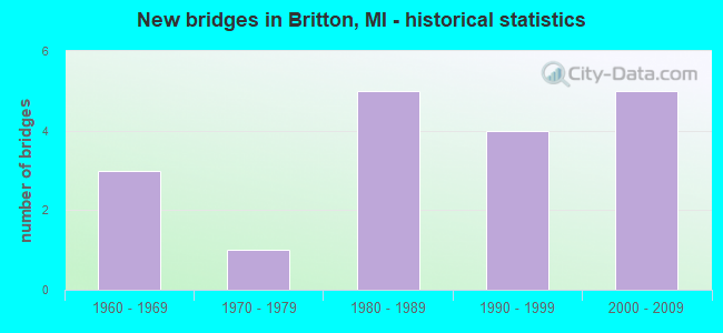
- New bridges - historical statistics
- 31960-1969
- 11970-1979
- 51980-1989
- 41990-1999
- 52000-2009
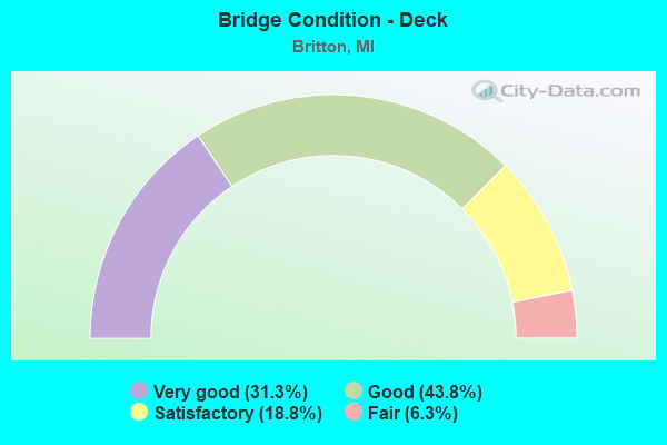
- Bridge Condition - Deck
- 31.3%Very good
- 43.8%Good
- 18.8%Satisfactory
- 6.3%Fair
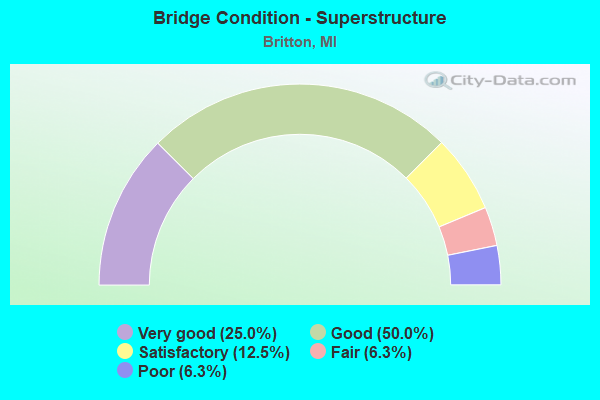
- Bridge Condition - Superstructure
- 25.0%Very good
- 50.0%Good
- 12.5%Satisfactory
- 6.3%Fair
- 6.3%Poor
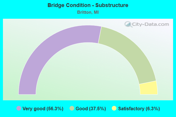
- Bridge Condition - Substructure
- 56.3%Very good
- 37.5%Good
- 6.3%Satisfactory
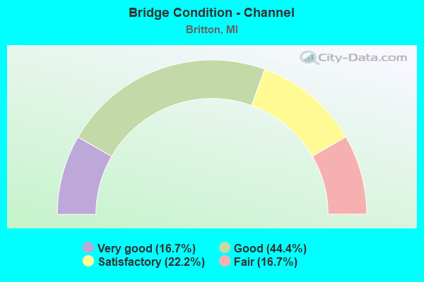
- Bridge Condition - Channel
- 16.7%Very good
- 44.4%Good
- 22.2%Satisfactory
- 16.7%Fair
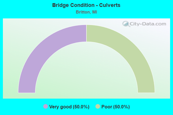
- Bridge Condition - Culverts
- 50.0%Very good
- 50.0%Poor
Find on map >> Show street view
Structure Number: 554, Location: 3 MI N OF MIDDLEVILLE (Lat: 42.755706, Lng: -85.461247), Route carried "on" structure: County highway 892, Year Built: 1968, Status: Open, Structure Length: 4.57m (14.99ft), Average Daily Traffic: 1,147 (year 2015), Truck Traffic: 2%, Average Future Daily Traffic: 1,205 (year 2035), Design Load: HS 20+Mod, Features Intersected: THORNAPPLE RIVER, Facility Carried by Structure: PARMALEE ROAD
Minimum Vertical Clearance: 30.48m (100.00ft), Kilometerpoint: 4.920, Lanes on structure: 2, Owner: County Highway Agency, Approaching Roadway Width: 9.6m (31.5ft), Skew: 1 degrees, Material/Design: Prestressed concrete, Design/Construction: Box Beam or Girders - Multiple, Number Of Spans In Main Unit: 3, Length of Maximum Span: 15.2m (49.9ft), Curb-To-Curb Width: 9.5m (31.2ft), Out-to-Out Width: 10.1m (33.1ft)
Condition: Deck: Satisfactory, Superstructure: Poor, Substructure: Satisfactory, Channel: Satisfactory, Operating Rating: 56.1 metric tons, Method Used To Determine Operating Rating: Load Factor (LF) rating reported by rating factor (RF) method using MS18 loading, Inventory Rating: 33.7 metric tons, Method Used To Determine Inventory Rating: Load Factor (LF) rating reported by rating factor (RF) method using MS18 loading, Structural Evaluation: Meets minimum limits, Deck Geometry: Somewhat better than minimum adequacy, Waterway Adequacy: Equal to present minimum criteria, Approach Roadway Alignment: Better than present minimum criteria, Length Of Structure Improvement: 4.57m (14.99ft), Designated Inspection Frequency: Every 12 months, Inspection Date: July 2021, Bridge Improvement Cost: $8,000, Total Project Cost: $8,000, Deck Structure Type: Concrete Precast Panels, Wearing Surface/Protective System: Wearing Surface: Bituminous, Membrane: Preformed Fabric
Find on map >> Show street view
Structure Number: 5537, Location: 1.1 MI E OF BRITTON (Lat: 41.983594, Lng: -83.812558), Route carried "on" structure: State highway 50, Year Built: 2000, Status: Open, Structure Length: 0.70m (2.30ft), Average Daily Traffic: 6,646 (year 2007), Truck Traffic: 6%, Average Future Daily Traffic: 15,934 (year 2018), Design Load: HS 25 or greater, Features Intersected: SCHREEDER BROOK
Minimum Vertical Clearance: 30.48m (100.00ft), Kilometerpoint: 37.654, Lanes on structure: 2, Base Highway Network: Yes (Inventory Route: 94, Subroute: 5), Owner: State Highway Agency, Approaching Roadway Width: 13.4m (44.0ft), Material/Design: Prestressed concrete, Design/Construction: Box Beam or Girders - Multiple, Number Of Spans In Main Unit: 1, Length of Maximum Span: 7.0m (23.0ft), Curb or Sidewalk Widths: Left: 0.4m (1.3ft), Right: 0.4m (1.3ft), Curb-To-Curb Width: 12.2m (40.0ft), Out-to-Out Width: 13.8m (45.3ft)
Condition: Deck: Fair, Superstructure: Good, Substructure: Good, Channel: Satisfactory, Operating Rating: 83.6 metric tons, Method Used To Determine Operating Rating: Load Factor (LF) rating reported by rating factor (RF) method using MS18 loading, Inventory Rating: 44.7 metric tons, Method Used To Determine Inventory Rating: Load Factor (LF) rating reported by rating factor (RF) method using MS18 loading, Structural Evaluation: Better than present minimum criteria, Deck Geometry: Somewhat better than minimum adequacy, Waterway Adequacy: Equal to present minimum criteria, Approach Roadway Alignment: Equal to present desirable criteria, Designated Inspection Frequency: Every 24 months, Inspection Date: September 2020, Deck Structure Type: Concrete Cast-file-Place, Wearing Surface/Protective System: Wearing Surface: Monolithic Concrete, Deck Protection: Epoxy Coated Reinforcing
Find on map >> Show street view
Structure Number: 554, Location: WEST LIMITS OF BRITTON (Lat: 41.987650, Lng: -83.836161), Route carried "on" structure: State highway 50, Year Built: 2000, Status: Open, Structure Length: 1.05m (3.44ft), Average Daily Traffic: 6,842 (year 2007), Truck Traffic: 7%, Average Future Daily Traffic: 7,860 (year 2017), Design Load: HS 25 or greater, Features Intersected: WILSON SPRING DRAIN
Minimum Vertical Clearance: 30.48m (100.00ft), Kilometerpoint: 35.650, Lanes on structure: 2, Base Highway Network: Yes (Inventory Route: 94, Subroute: 5), Owner: State Highway Agency, Approaching Roadway Width: 14.3m (46.9ft), Material/Design: Prestressed concrete, Design/Construction: Box Beam or Girders - Single/Spread, Number Of Spans In Main Unit: 1, Length of Maximum Span: 9.5m (31.2ft), Curb-To-Curb Width: 13.1m (43.0ft), Out-to-Out Width: 14.2m (46.6ft)
Condition: Deck: Good, Superstructure: Good, Substructure: Good, Channel: Good, Operating Rating: 63.2 metric tons, Method Used To Determine Operating Rating: Load Factor (LF) rating reported by rating factor (RF) method using MS18 loading, Inventory Rating: 37.9 metric tons, Method Used To Determine Inventory Rating: Load Factor (LF) rating reported by rating factor (RF) method using MS18 loading, Structural Evaluation: Better than present minimum criteria, Deck Geometry: Somewhat better than minimum adequacy, Waterway Adequacy: Equal to present minimum criteria, Approach Roadway Alignment: Equal to present desirable criteria, Designated Inspection Frequency: Every 24 months, Inspection Date: September 2020, Deck Structure Type: Concrete Cast-file-Place, Wearing Surface/Protective System: Wearing Surface: Monolithic Concrete, Deck Protection: Epoxy Coated Reinforcing
Find on map >> Show street view
Structure Number: 5577, Location: 0.5 MI E OF BRITTON HWY (Lat: 42.009033, Lng: -83.820717), Route carried "on" structure: County highway , Year Built: 1978, Status: Open, Structure Length: 1.22m (4.00ft), Average Daily Traffic: 217 (year 2011), Truck Traffic: 2%, Average Future Daily Traffic: 900 (year 2031), Design Load: H 20, Features Intersected: MACON RIVER MIDDLE BR, Facility Carried by Structure: MILWAUKEE RD
Minimum Vertical Clearance: 30.48m (100.00ft), Kilometerpoint: 7.390, Lanes on structure: 2, Owner: County Highway Agency, Approaching Roadway Width: 6.7m (22.0ft), Material/Design: Prestressed concrete, Design/Construction: Tee Beam, Number Of Spans In Main Unit: 1, Length of Maximum Span: 11.6m (38.1ft), Curb-To-Curb Width: 8.8m (28.9ft), Out-to-Out Width: 9.1m (29.9ft)
Condition: Deck: Good, Superstructure: Satisfactory, Substructure: Very good, Channel: Satisfactory, Operating Rating: 39.5 metric tons, Method Used To Determine Operating Rating: Load Factor (LF), Inventory Rating: 23.7 metric tons, Method Used To Determine Inventory Rating: Load Factor (LF), Structural Evaluation: Equal to present minimum criteria, Deck Geometry: Equal to present minimum criteria, Waterway Adequacy: Equal to present minimum criteria, Approach Roadway Alignment: Equal to present desirable criteria, Designated Inspection Frequency: Every 24 months, Inspection Date: March 2021, Deck Structure Type: Concrete Precast Panels, Wearing Surface/Protective System: Wearing Surface: Bituminous
Find on map >> Show street view
Structure Number: 5602, Location: WEST OF BRITTON HWY (Lat: 42.021989, Lng: -83.835319), Route carried "on" structure: County highway 4675, Year Built: 1997, Status: Open, Structure Length: 1.49m (4.89ft), Average Daily Traffic: 5,309 (year 2011), Truck Traffic: 3%, Average Future Daily Traffic: 7,500 (year 2031), Design Load: HS 20, Features Intersected: MACON RIVER, Facility Carried by Structure: RIDGE HWY
Minimum Vertical Clearance: 30.48m (100.00ft), Kilometerpoint: 11.293, Lanes on structure: 2, Owner: County Highway Agency, Approaching Roadway Width: 9.8m (32.2ft), Material/Design: Prestressed concrete, Design/Construction: Box Beam or Girders - Multiple, Number Of Spans In Main Unit: 1, Length of Maximum Span: 13.7m (44.9ft), Curb-To-Curb Width: 10.1m (33.1ft), Out-to-Out Width: 10.5m (34.4ft)
Condition: Deck: Very good, Superstructure: Very good, Substructure: Very good, Channel: Good, Operating Rating: 55.3 metric tons, Method Used To Determine Operating Rating: Load Factor (LF), Inventory Rating: 33.2 metric tons, Method Used To Determine Inventory Rating: Load Factor (LF), Structural Evaluation: Equal to present desirable criteria, Deck Geometry: Meets minimum limits, Waterway Adequacy: Better than present minimum criteria, Approach Roadway Alignment: High priority of corrective action, Designated Inspection Frequency: Every 24 months, Inspection Date: March 2021, Deck Structure Type: Concrete Cast-file-Place, Wearing Surface/Protective System: Wearing Surface: Bituminous
Find on map >> Show street view
Structure Number: 5603, Location: 0.2 MI SOUTH OF SMITH RD (Lat: 42.019500, Lng: -83.830722), Route carried "on" structure: County highway 4685, Year Built: 1963, Status: Open, Structure Length: 1.34m (4.40ft), Average Daily Traffic: 1,035 (year 2019), Truck Traffic: 4%, Average Future Daily Traffic: 1,750 (year 2039), Design Load: H 20, Features Intersected: MACON RIVER, Facility Carried by Structure: BRITTON HWY
Minimum Vertical Clearance: 30.48m (100.00ft), Kilometerpoint: 2.789, Lanes on structure: 2, Owner: County Highway Agency, Approaching Roadway Width: 9.1m (29.9ft), Material/Design: Prestressed concrete, Design/Construction: Box Beam or Girders - Multiple, Number Of Spans In Main Unit: 1, Length of Maximum Span: 13.4m (44.0ft), Curb-To-Curb Width: 7.3m (24.0ft), Out-to-Out Width: 8.4m (27.6ft)
Condition: Deck: Good, Superstructure: Good, Substructure: Good, Channel: Fair, Operating Rating: 48.8 metric tons, Method Used To Determine Operating Rating: Load Factor (LF), Inventory Rating: 29.3 metric tons, Method Used To Determine Inventory Rating: Load Factor (LF), Structural Evaluation: Better than present minimum criteria, Deck Geometry: Meets minimum limits, Waterway Adequacy: Better than present minimum criteria, Approach Roadway Alignment: Equal to present desirable criteria, Designated Inspection Frequency: Every 24 months, Inspection Date: March 2021, Deck Structure Type: Concrete Precast Panels, Wearing Surface/Protective System: Wearing Surface: Bituminous
Find on map >> Show street view
Structure Number: 5604, Location: 0.5 MI SOUTH OF WELCH RD (Lat: 42.028792, Lng: -83.830936), Route carried "on" structure: County highway 4685, Year Built: 1964, Status: Open, Structure Length: 1.10m (3.61ft), Average Daily Traffic: 1,130 (year 2011), Truck Traffic: 2%, Average Future Daily Traffic: 2,500 (year 2031), Design Load: H 15, Features Intersected: MACON RIVER, Facility Carried by Structure: BRITTON HWY
Minimum Vertical Clearance: 30.48m (100.00ft), Kilometerpoint: 3.821, Lanes on structure: 2, Owner: County Highway Agency, Approaching Roadway Width: 10.4m (34.1ft), Material/Design: Prestressed concrete, Design/Construction: Box Beam or Girders - Multiple, Number Of Spans In Main Unit: 1, Length of Maximum Span: 10.6m (34.8ft), Curb-To-Curb Width: 8.2m (26.9ft), Out-to-Out Width: 8.5m (27.9ft)
Condition: Deck: Good, Superstructure: Good, Substructure: Good, Channel: Very good, Operating Rating: 58.1 metric tons, Method Used To Determine Operating Rating: Load Factor (LF), Inventory Rating: 34.8 metric tons, Method Used To Determine Inventory Rating: Load Factor (LF), Structural Evaluation: Better than present minimum criteria, Deck Geometry: Meets minimum limits, Waterway Adequacy: Equal to present desirable criteria, Approach Roadway Alignment: Equal to present desirable criteria, Designated Inspection Frequency: Every 24 months, Inspection Date: March 2021, Deck Structure Type: Concrete Precast Panels, Wearing Surface/Protective System: Wearing Surface: Bituminous
Find on map >> Show street view
Structure Number: 5605, Location: 0.5 MI NORTH OF WELCH RD (Lat: 42.046903, Lng: -83.831461), Route carried "on" structure: County highway 4685, Year Built: 1989, Status: Open, Structure Length: 1.22m (4.00ft), Average Daily Traffic: 1,130 (year 2011), Truck Traffic: 2%, Average Future Daily Traffic: 2,500 (year 2031), Design Load: HS 20, Features Intersected: MACON RIVER, Facility Carried by Structure: BRITTON HWY
Minimum Vertical Clearance: 30.48m (100.00ft), Kilometerpoint: 5.832, Lanes on structure: 2, Owner: County Highway Agency, Approaching Roadway Width: 7.9m (25.9ft), Material/Design: Wood or Timber, Design/Construction: Slab, Number Of Spans In Main Unit: 2, Length of Maximum Span: 6.1m (20.0ft), Curb-To-Curb Width: 9.1m (29.9ft), Out-to-Out Width: 9.5m (31.2ft)
Condition: Deck: Very good, Superstructure: Very good, Substructure: Very good, Channel: Good, Operating Rating: 64.6 metric tons, Method Used To Determine Operating Rating: Allowable Stress (AS), Inventory Rating: 46.3 metric tons, Method Used To Determine Inventory Rating: Allowable Stress (AS), Structural Evaluation: Equal to present desirable criteria, Deck Geometry: Somewhat better than minimum adequacy, Waterway Adequacy: Better than present minimum criteria, Approach Roadway Alignment: Equal to present desirable criteria, Designated Inspection Frequency: Every 24 months, Inspection Date: March 2021, Deck Structure Type: Wood or Timber, Wearing Surface/Protective System: Wearing Surface: Bituminous, Deck Protection: Other
Find on map >> Show street view
Structure Number: 5651, Location: 0.5 MI E OF BRITTON HWY (Lat: 42.038108, Lng: -83.822828), Route carried "on" structure: County highway , Year Built: 1983, Status: Open, Structure Length: 1.37m (4.49ft), Average Daily Traffic: 119 (year 2011), Truck Traffic: 1%, Average Future Daily Traffic: 200 (year 2031), Design Load: HS 20, Features Intersected: MACON RIVER, Facility Carried by Structure: WELCH RD
Minimum Vertical Clearance: 30.48m (100.00ft), Kilometerpoint: 3.917, Lanes on structure: 2, Owner: County Highway Agency, Approaching Roadway Width: 10.1m (33.1ft), Material/Design: Prestressed concrete, Design/Construction: Box Beam or Girders - Multiple, Number Of Spans In Main Unit: 1, Length of Maximum Span: 13.3m (43.6ft), Curb-To-Curb Width: 9.1m (29.9ft), Out-to-Out Width: 9.4m (30.8ft)
Condition: Deck: Good, Superstructure: Good, Substructure: Very good, Channel: Good, Operating Rating: 68.7 metric tons, Method Used To Determine Operating Rating: Load Factor (LF), Inventory Rating: 41.2 metric tons, Method Used To Determine Inventory Rating: Load Factor (LF), Structural Evaluation: Better than present minimum criteria, Deck Geometry: Equal to present minimum criteria, Waterway Adequacy: Equal to present desirable criteria, Approach Roadway Alignment: Equal to present desirable criteria, Designated Inspection Frequency: Every 24 months, Inspection Date: March 2021, Deck Structure Type: Concrete Precast Panels, Wearing Surface/Protective System: Wearing Surface: Bituminous, Membrane: Other
Find on map >> Show street view
Structure Number: 5652, Location: 0.4 MI E OF MILLS-MACON (Lat: 42.052533, Lng: -83.841864), Route carried "on" structure: County highway , Year Built: 1990, Status: Open, Structure Length: 1.09m (3.58ft), Average Daily Traffic: 97 (year 2011), Truck Traffic: 1%, Average Future Daily Traffic: 250 (year 2031), Design Load: HS 20, Features Intersected: MIDDLE BR OF MACON RIVER, Facility Carried by Structure: PENNINGTON RD
Minimum Vertical Clearance: 30.48m (100.00ft), Kilometerpoint: 9.838, Lanes on structure: 2, Owner: County Highway Agency, Approaching Roadway Width: 6.7m (22.0ft), Material/Design: Wood or Timber, Design/Construction: Slab, Number Of Spans In Main Unit: 2, Length of Maximum Span: 5.1m (16.7ft), Curb-To-Curb Width: 7.3m (24.0ft), Out-to-Out Width: 7.7m (25.3ft)
Condition: Deck: Good, Superstructure: Good, Substructure: Good, Channel: Fair, Operating Rating: 46.9 metric tons, Method Used To Determine Operating Rating: Allowable Stress (AS), Inventory Rating: 34.0 metric tons, Method Used To Determine Inventory Rating: Allowable Stress (AS), Structural Evaluation: Better than present minimum criteria, Deck Geometry: Equal to present minimum criteria, Waterway Adequacy: Meets minimum limits, Approach Roadway Alignment: Equal to present desirable criteria, Designated Inspection Frequency: Every 24 months, Inspection Date: Febuary 2021, Deck Structure Type: Wood or Timber, Wearing Surface/Protective System: Wearing Surface: Bituminous, Deck Protection: Other
Find on map >> Show street view
Structure Number: 5656, Location: 0.3 MI S OF MILWAUKEE RD (Lat: 42.003928, Lng: -83.810706), Route carried "on" structure: County highway , Year Built: 1983, Status: Open, Structure Length: 1.46m (4.79ft), Average Daily Traffic: 69 (year 2011), Truck Traffic: 1%, Average Future Daily Traffic: 230 (year 2031), Design Load: HS 20, Features Intersected: MIDDLE BR OF MACON RIVER, Facility Carried by Structure: HOAGLAND HWY
Minimum Vertical Clearance: 30.48m (100.00ft), Kilometerpoint: 1.032, Lanes on structure: 2, Owner: County Highway Agency, Approaching Roadway Width: 10.1m (33.1ft), Material/Design: Prestressed concrete, Design/Construction: Box Beam or Girders - Multiple, Number Of Spans In Main Unit: 1, Length of Maximum Span: 13.4m (44.0ft), Curb-To-Curb Width: 9.4m (30.8ft), Out-to-Out Width: 9.5m (31.2ft)
Condition: Deck: Satisfactory, Superstructure: Satisfactory, Substructure: Good, Channel: Satisfactory, Operating Rating: 57.1 metric tons, Method Used To Determine Operating Rating: Load Factor (LF), Inventory Rating: 34.3 metric tons, Method Used To Determine Inventory Rating: Load Factor (LF), Structural Evaluation: Equal to present minimum criteria, Deck Geometry: Better than present minimum criteria, Waterway Adequacy: Equal to present desirable criteria, Approach Roadway Alignment: Equal to present desirable criteria, Designated Inspection Frequency: Every 24 months, Inspection Date: March 2021, Deck Structure Type: Concrete Precast Panels, Wearing Surface/Protective System: Wearing Surface: Bituminous, Membrane: Other
Find on map >> Show street view
Structure Number: 5687, Location: NORTH OF DOWNING HWY (Lat: 41.997403, Lng: -83.790953), Route carried "on" structure: County highway , Year Built: 1985, Status: Open, Structure Length: 2.44m (8.01ft), Average Daily Traffic: 36 (year 2011), Average Future Daily Traffic: 225 (year 2031), Design Load: HS 20, Features Intersected: MIDDLE BR MACON RIVER, Facility Carried by Structure: SHAW HWY
Minimum Vertical Clearance: 30+ m (98+ ft), Kilometerpoint: 0.048, Lanes on structure: 2, Owner: County Highway Agency, Approaching Roadway Width: 6.1m (20.0ft), Material/Design: Prestressed concrete, Design/Construction: Box Beam or Girders - Multiple, Number Of Spans In Main Unit: 1, Length of Maximum Span: 23.8m (78.1ft), Curb-To-Curb Width: 9.4m (30.8ft), Out-to-Out Width: 9.4m (30.8ft)
Condition: Deck: Satisfactory, Superstructure: Fair, Substructure: Very good, Channel: Good, Operating Rating: 60.2 metric tons, Method Used To Determine Operating Rating: Load Factor (LF), Inventory Rating: 36.1 metric tons, Method Used To Determine Inventory Rating: Load Factor (LF), Structural Evaluation: Somewhat better than minimum adequacy, Deck Geometry: Better than present minimum criteria, Waterway Adequacy: Better than present minimum criteria, Approach Roadway Alignment: Better than present minimum criteria, Designated Inspection Frequency: Every 24 months, Inspection Date: Febuary 2021, Deck Structure Type: Concrete Precast Panels, Wearing Surface/Protective System: Wearing Surface: Bituminous, Membrane: Other
Find on map >> Show street view
Structure Number: 5689, Location: 0.1 MI W OF HOAGLAND HWY (Lat: 41.980128, Lng: -83.812300), Route carried "on" structure: County highway , Year Built: 1980, Status: Open, Structure Length: 0.61m (2.00ft), Average Daily Traffic: 57 (year 2011), Truck Traffic: 1%, Average Future Daily Traffic: 175 (year 2025), Design Load: HS 20+Mod, Features Intersected: SCHROEDER BROOK DRAIN, Facility Carried by Structure: CENTENNIAL RD
Minimum Vertical Clearance: 30.48m (100.00ft), Kilometerpoint: 9.465, Lanes on structure: 2, Owner: County Highway Agency, Approaching Roadway Width: 6.4m (21.0ft), Material/Design: Wood or Timber, Design/Construction: Culvert, Number Of Spans In Main Unit: 3, Length of Maximum Span: 1.8m (5.9ft)
Condition: Channel: Fair, Culverts: Poor, Operating Rating: 32.7 metric tons, Method Used To Determine Operating Rating: Allowable Stress (AS), Inventory Rating: 24.5 metric tons, Method Used To Determine Inventory Rating: Allowable Stress (AS), Structural Evaluation: Meets minimum limits, Waterway Adequacy: Better than present minimum criteria, Approach Roadway Alignment: Equal to present desirable criteria, Designated Inspection Frequency: Every 12 months, Inspection Date: November 2021, Deck Structure Type: Wood or Timber, Wearing Surface/Protective System: Wearing Surface: Gravel, Deck Protection: Other
Find on map >> Show street view
Structure Number: 569, Location: 0.5 MI W OF N COUNTY LINE (Lat: 41.995078, Lng: -83.780342), Route carried "on" structure: County highway , Year Built: 1995, Status: Open, Structure Length: 1.67m (5.48ft), Average Daily Traffic: 28 (year 2011), Average Future Daily Traffic: 110 (year 2031), Design Load: HS 20, Features Intersected: MIDDLE BR OF MACON RIVER, Facility Carried by Structure: KNIFFIN RD
Minimum Vertical Clearance: 30.48m (100.00ft), Kilometerpoint: 4.159, Lanes on structure: 2, Owner: County Highway Agency, Approaching Roadway Width: 7.9m (25.9ft), Material/Design: Prestressed concrete, Design/Construction: Box Beam or Girders - Multiple, Number Of Spans In Main Unit: 1, Length of Maximum Span: 15.5m (50.9ft), Curb-To-Curb Width: 9.1m (29.9ft), Out-to-Out Width: 9.4m (30.8ft)
Condition: Deck: Very good, Superstructure: Good, Substructure: Very good, Channel: Good, Operating Rating: 77.8 metric tons, Method Used To Determine Operating Rating: Load Factor (LF), Inventory Rating: 46.7 metric tons, Method Used To Determine Inventory Rating: Load Factor (LF), Structural Evaluation: Better than present minimum criteria, Deck Geometry: Better than present minimum criteria, Waterway Adequacy: Better than present minimum criteria, Approach Roadway Alignment: Equal to present desirable criteria, Designated Inspection Frequency: Every 24 months, Inspection Date: Febuary 2021, Deck Structure Type: Concrete Cast-file-Place, Wearing Surface/Protective System: Wearing Surface: Monolithic Concrete, Deck Protection: Epoxy Coated Reinforcing
Find on map >> Show street view
Structure Number: 5691, Location: 0.1 MI NORTH OF HOLLOWAY (Lat: 41.936550, Lng: -83.809850), Route carried "on" structure: County highway , Year Built: 2003, Status: Open, Structure Length: 0.91m (2.99ft), Average Daily Traffic: 36 (year 2011), Truck Traffic: 1%, Average Future Daily Traffic: 100 (year 2031), Design Load: HS 25 or greater, Features Intersected: SCHENK BEN KELLY DRAIN, Facility Carried by Structure: HOAGLAND HWY
Minimum Vertical Clearance: 30.48m (100.00ft), Kilometerpoint: 0.018, Lanes on structure: 2, Owner: County Highway Agency, Approaching Roadway Width: 8.5m (27.9ft), Material/Design: Concrete, Design/Construction: Culvert, Number Of Spans In Main Unit: 1, Length of Maximum Span: 8.5m (27.9ft), Curb-To-Curb Width: 8.5m (27.9ft), Out-to-Out Width: 10.9m (35.8ft)
Condition: Channel: Very good, Culverts: Very good, Operating Rating: 54.5 metric tons, Method Used To Determine Operating Rating: Field evaluation and documented engineering judgment, Inventory Rating: 32.7 metric tons, Method Used To Determine Inventory Rating: Field evaluation and documented engineering judgment, Structural Evaluation: Equal to present desirable criteria, Deck Geometry: Better than present minimum criteria, Waterway Adequacy: Equal to present desirable criteria, Approach Roadway Alignment: Superior to present desirable criteria, Designated Inspection Frequency: Every 24 months, Inspection Date: Febuary 2021, Deck Structure Type: Other
Find on map >> Show street view
Structure Number: 5692, Location: 0.5 MI NORTH OF SUTTON RD (Lat: 41.957522, Lng: -83.810692), Route carried "on" structure: County highway , Year Built: 2007, Status: Open, Structure Length: 1.65m (5.41ft), Average Daily Traffic: 79 (year 2011), Average Future Daily Traffic: 180 (year 2031), Design Load: HS 25 or greater, Features Intersected: LITTLE RIVER RAISIN, Facility Carried by Structure: HOAGLAND HWY
Minimum Vertical Clearance: 30.48m (100.00ft), Kilometerpoint: 2.347, Lanes on structure: 2, Owner: County Highway Agency, Approaching Roadway Width: 8.5m (27.9ft), Skew: 2 degrees, Material/Design: Prestressed concrete, Design/Construction: Box Beam or Girders - Multiple, Number Of Spans In Main Unit: 1, Length of Maximum Span: 15.1m (49.5ft), Curb-To-Curb Width: 8.8m (28.9ft), Out-to-Out Width: 9.5m (31.2ft)
Condition: Deck: Very good, Superstructure: Very good, Substructure: Very good, Channel: Very good, Operating Rating: 70.8 metric tons, Method Used To Determine Operating Rating: Load Factor (LF), Inventory Rating: 42.5 metric tons, Method Used To Determine Inventory Rating: Load Factor (LF), Structural Evaluation: Equal to present desirable criteria, Deck Geometry: Better than present minimum criteria, Waterway Adequacy: Equal to present minimum criteria, Approach Roadway Alignment: Better than present minimum criteria, Designated Inspection Frequency: Every 24 months, Inspection Date: December 2020, Deck Structure Type: Concrete Cast-file-Place, Wearing Surface/Protective System: Deck Protection: Epoxy Coated Reinforcing
Find on map >> Show street view
Structure Number: 5693, Location: 0.2 MI NORTH OF SUTTON RD (Lat: 41.954514, Lng: -83.800750), Route carried "on" structure: County highway , Year Built: 2007, Status: Open, Structure Length: 1.46m (4.79ft), Average Daily Traffic: 34 (year 2011), Average Future Daily Traffic: 250 (year 2031), Design Load: HS 25 or greater, Features Intersected: LITTLE RIVER RAISIN, Facility Carried by Structure: DOWNING HWY
Minimum Vertical Clearance: 30.48m (100.00ft), Kilometerpoint: 0.373, Lanes on structure: 2, Owner: County Highway Agency, Approaching Roadway Width: 8.5m (27.9ft), Material/Design: Prestressed concrete, Design/Construction: Box Beam or Girders - Multiple, Number Of Spans In Main Unit: 1, Length of Maximum Span: 13.4m (44.0ft), Curb-To-Curb Width: 8.8m (28.9ft), Out-to-Out Width: 9.5m (31.2ft)
Condition: Deck: Very good, Superstructure: Very good, Substructure: Very good, Channel: Good, Operating Rating: 69.1 metric tons, Method Used To Determine Operating Rating: Load Factor (LF), Inventory Rating: 41.5 metric tons, Method Used To Determine Inventory Rating: Load Factor (LF), Structural Evaluation: Equal to present desirable criteria, Deck Geometry: Better than present minimum criteria, Waterway Adequacy: Equal to present desirable criteria, Approach Roadway Alignment: Somewhat better than minimum adequacy, Designated Inspection Frequency: Every 24 months, Inspection Date: December 2020, Deck Structure Type: Concrete Cast-file-Place, Wearing Surface/Protective System: Wearing Surface: Monolithic Concrete, Deck Protection: Epoxy Coated Reinforcing
Find on map >> Show street view
Structure Number: 12681, Location: 1.0 MI NO OF M 50 (Lat: 41.993458, Lng: -83.771425), Route carried "on" structure: County highway , Year Built: 1994, Status: Open, Structure Length: 1.98m (6.50ft), Average Daily Traffic: 110 (year 2016), Truck Traffic: 2%, Average Future Daily Traffic: 127 (year 2036), Design Load: HS 20, Features Intersected: N DR MID BR MACON R, Facility Carried by Structure: LENAWEE CO LINE RD
Minimum Vertical Clearance: 30.48m (100.00ft), Kilometerpoint: 5.456, Lanes on structure: 2, Owner: County Highway Agency, Approaching Roadway Width: 8.5m (27.9ft), Material/Design: Prestressed concrete, Design/Construction: Box Beam or Girders - Multiple, Number Of Spans In Main Unit: 1, Length of Maximum Span: 19.2m (63.0ft), Curb-To-Curb Width: 9.8m (32.2ft), Out-to-Out Width: 10.5m (34.4ft)
Condition: Deck: Good, Superstructure: Good, Substructure: Very good, Channel: Good, Operating Rating: 52.5 metric tons, Method Used To Determine Operating Rating: Load Factor (LF) rating reported by rating factor (RF) method using MS18 loading, Inventory Rating: 28.8 metric tons, Method Used To Determine Inventory Rating: Load Factor (LF) rating reported by rating factor (RF) method using MS18 loading, Structural Evaluation: Better than present minimum criteria, Deck Geometry: Better than present minimum criteria, Waterway Adequacy: Superior to present desirable criteria, Approach Roadway Alignment: Equal to present minimum criteria, Designated Inspection Frequency: Every 24 months, Inspection Date: October 2020, Deck Structure Type: Concrete Cast-file-Place, Wearing Surface/Protective System: Wearing Surface: Monolithic Concrete, Deck Protection: Epoxy Coated Reinforcing