Bridge Statistics for Burgettstown, Pennsylvania (PA)
Condition, Traffic, Stress, Structural Evaluation, Project Costs
- National Bridge Inventory (NBI) Statistics
- 12Number of bridges
- 102ft / 30.6mTotal length
- $5,220,000Total costs
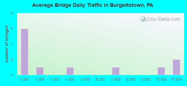
- 43,867Total average daily traffic
- 3,885Total average daily truck traffic
- National Bridge Inventory (NBI) Registered Bridges for Burgettstown
- No street view available for this location

- New bridges - historical statistics
- 11940-1949
- 11950-1959
- 31960-1969
- 51970-1979
- 12000-2009
- 12010-2019
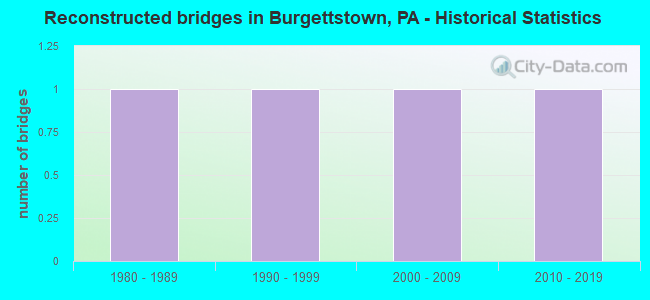
- Reconstructed bridges - Historical Statistics
- 11980-1989
- 11990-1999
- 12000-2009
- 12010-2019
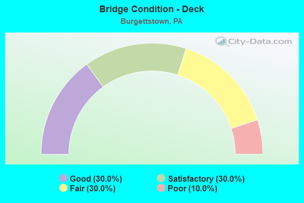
- Bridge Condition - Deck
- 30.0%Good
- 30.0%Satisfactory
- 30.0%Fair
- 10.0%Poor
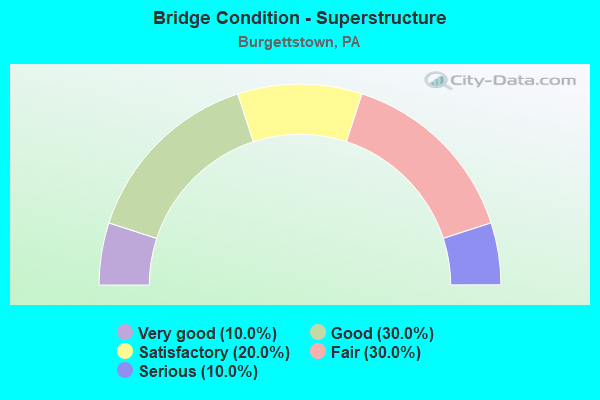
- Bridge Condition - Superstructure
- 10.0%Very good
- 30.0%Good
- 20.0%Satisfactory
- 30.0%Fair
- 10.0%Serious
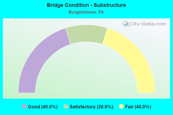
- Bridge Condition - Substructure
- 40.0%Good
- 20.0%Satisfactory
- 40.0%Fair
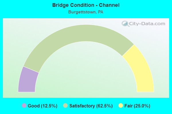
- Bridge Condition - Channel
- 12.5%Good
- 62.5%Satisfactory
- 25.0%Fair
Find on map >> Show street view
Structure Number: 3518, Location: TWP.RD.625 OVER TR 60 (Lat: 40.600789, Lng: -80.316631), Route carried "on" structure: State highway , Year Built: 1969, Year Reconstructed: 2017, Status: Open, Structure Length: 6.46m (21.19ft), Average Daily Traffic: 566 (year 2022), Truck Traffic: 8%, Average Future Daily Traffic: 791 (year 2032), Design Load: HS 20, Features Intersected: BEAVER VALLEY EX., Facility Carried by Structure: MAIN STREET
Minimum Vertical Clearance: 30+ m (98+ ft), Kilometerpoint: 0.000, Lanes on structure: 2, Lanes under structure: 8, Owner: State Highway Agency, Approaching Roadway Width: 8.5m (27.9ft), Material/Design: Prestressed concrete, Design/Construction: Box Beam or Girders - Single/Spread, Number Of Spans In Main Unit: 4, Length of Maximum Span: 18.3m (60.0ft), Curb or Sidewalk Widths: Left: 0.2m (0.7ft), Right: 0.2m (0.7ft), Curb-To-Curb Width: 9.8m (32.2ft), Out-to-Out Width: 11.0m (36.1ft)
Condition: Deck: Satisfactory, Superstructure: Satisfactory, Substructure: Satisfactory, Operating Rating: 59.0 metric tons, Method Used To Determine Operating Rating: Load Factor (LF), Inventory Rating: 31.8 metric tons, Method Used To Determine Inventory Rating: Load Factor (LF), Structural Evaluation: Equal to present minimum criteria, Deck Geometry: Equal to present minimum criteria, Underclear: High priority of corrective action, Approach Roadway Alignment: Equal to present desirable criteria, Length Of Structure Improvement: 7.40m (24.28ft), Designated Inspection Frequency: Every 24 months, Inspection Date: April 2021, Bridge Improvement Cost: $33,000, Roadway Improvement Cost: $98,000, Total Project Cost: $449,000, Deck Structure Type: Concrete Cast-file-Place, Wearing Surface/Protective System: Wearing Surface: Latex Concrete
Find on map >> Show street view
Structure Number: 4206, Location: .5 MI.E.OF YELLOW CREEK (Lat: 40.128578, Lng: -78.324453), Route carried "on" structure: State highway , Year Built: 1954, Year Reconstructed: 2012, Status: Open, Structure Length: 3.87m (12.70ft), Average Daily Traffic: 339 (year 2020), Truck Traffic: 4%, Average Future Daily Traffic: 518 (year 2032), Design Load: HL 93, Features Intersected: YELLOW CREEK, Facility Carried by Structure: T531 PRICES HILL R
Minimum Vertical Clearance: 30+ m (98+ ft), Kilometerpoint: 0.000, Lanes on structure: 2, Owner: State Highway Agency, Approaching Roadway Width: 5.5m (18.0ft), Material/Design: Steel, Design/Construction: Stringer/Multi-beam, Number Of Spans In Main Unit: 2, Length of Maximum Span: 18.6m (61.0ft), Curb-To-Curb Width: 7.2m (23.6ft), Out-to-Out Width: 7.9m (25.9ft)
Condition: Deck: Good, Superstructure: Satisfactory, Substructure: Good, Channel: Fair, Operating Rating: 75.5 metric tons, Method Used To Determine Operating Rating: Assigned ratings based on Load and Resistance Factor Design (LRFD) reported by rating factor (RF) using HL93 loadings, Inventory Rating: 58.0 metric tons, Method Used To Determine Inventory Rating: Assigned ratings based on Load and Resistance Factor Design (LRFD) reported by rating factor (RF) using HL93 loadings, Structural Evaluation: Equal to present minimum criteria, Deck Geometry: Meets minimum limits, Waterway Adequacy: Better than present minimum criteria, Approach Roadway Alignment: Equal to present desirable criteria, Length Of Structure Improvement: 4.80m (15.75ft), Designated Inspection Frequency: Every 48 months, Inspection Date: July 2019, Bridge Improvement Cost: $117,000, Roadway Improvement Cost: $344,000, Total Project Cost: $1,577,000, Deck Structure Type: Concrete Cast-file-Place, Wearing Surface/Protective System: Wearing Surface: Monolithic Concrete, Deck Protection: Epoxy Coated Reinforcing
Find on map >> Show street view
Structure Number: 34326, Location: BURGETTSTOWN BOROUGH (Lat: 40.386072, Lng: -80.389094), Route carried "on" structure: State highway 18, Year Built: 1973, Status: Open, Structure Length: 3.41m (11.19ft), Average Daily Traffic: 9,646 (year 2020), Truck Traffic: 6%, Average Future Daily Traffic: 15,120 (year 2032), Design Load: HS 20, Features Intersected: BURGETTS FORK RACCOON CK
Minimum Vertical Clearance: 30+ m (98+ ft), Kilometerpoint: 55.303, Lanes on structure: 4, Owner: State Highway Agency, Approaching Roadway Width: 17.1m (56.1ft), Skew: 25 degrees, Material/Design: Steel continuous, Design/Construction: Stringer/Multi-beam, Number Of Spans In Main Unit: 2, Length of Maximum Span: 16.5m (54.1ft), Curb or Sidewalk Widths: Left: 1.5m (4.9ft), Right: 1.5m (4.9ft), Curb-To-Curb Width: 17.1m (56.1ft), Out-to-Out Width: 20.9m (68.6ft)
Condition: Deck: Fair, Superstructure: Fair, Substructure: Fair, Channel: Satisfactory, Operating Rating: 84.4 metric tons, Method Used To Determine Operating Rating: Load Factor (LF), Inventory Rating: 50.8 metric tons, Method Used To Determine Inventory Rating: Load Factor (LF), Structural Evaluation: Somewhat better than minimum adequacy, Deck Geometry: Somewhat better than minimum adequacy, Waterway Adequacy: High priority of corrective action, Approach Roadway Alignment: Equal to present desirable criteria, Length Of Structure Improvement: 4.30m (14.11ft), Designated Inspection Frequency: Every 24 months, Inspection Date: November 2021, Bridge Improvement Cost: $36,000, Roadway Improvement Cost: $105,000, Total Project Cost: $483,000, Deck Structure Type: Concrete Cast-file-Place, Wearing Surface/Protective System: Wearing Surface: Bituminous
Find on map >> Show street view
Structure Number: 3433, Location: HANOVER TOWNSHIP (Lat: 40.426053, Lng: -80.428889), Route carried "on" structure: State highway 18, Year Built: 1970, Year Reconstructed: 1990, Status: Open, Structure Length: 7.80m (25.59ft), Average Daily Traffic: 6,160 (year 2020), Truck Traffic: 8%, Average Future Daily Traffic: 7,494 (year 2032), Design Load: HS 20, Features Intersected: SR 0022
Minimum Vertical Clearance: 30+ m (98+ ft), Kilometerpoint: 61.458, Lanes on structure: 6, Lanes under structure: 8, Base Highway Network: Yes, Owner: State Highway Agency, Approaching Roadway Width: 25.6m (84.0ft), Skew: 31 degrees, Material/Design: Prestressed concrete, Design/Construction: Box Beam or Girders - Single/Spread, Number Of Spans In Main Unit: 4, Length of Maximum Span: 23.5m (77.1ft), Curb or Sidewalk Widths: Left: 0.2m (0.7ft), Right: 0.2m (0.7ft), Curb-To-Curb Width: 23.3m (76.4ft), Out-to-Out Width: 24.8m (81.4ft)
Condition: Deck: Fair, Superstructure: Fair, Substructure: Fair, Operating Rating: 57.2 metric tons, Method Used To Determine Operating Rating: Load Factor (LF), Inventory Rating: 34.5 metric tons, Method Used To Determine Inventory Rating: Load Factor (LF), Structural Evaluation: Somewhat better than minimum adequacy, Deck Geometry: Meets minimum limits, Underclear: Superior to present desirable criteria, Approach Roadway Alignment: Equal to present desirable criteria, Length Of Structure Improvement: 8.70m (28.54ft), Designated Inspection Frequency: Every 24 months, Inspection Date: October 2021, Bridge Improvement Cost: $164,000, Roadway Improvement Cost: $483,000, Total Project Cost: $2,214,000, Deck Structure Type: Concrete Cast-file-Place, Wearing Surface/Protective System: Wearing Surface: Bituminous
Find on map >> Show street view
Structure Number: 35122, Location: BURGETTSTOWN BOROUGH (Lat: 40.372389, Lng: -80.392594), Route carried "on" structure: State highway , Year Built: 1943, Year Reconstructed: 1987, Status: Open, Structure Length: 1.74m (5.71ft), Average Daily Traffic: 3,475 (year 2021), Truck Traffic: 9%, Average Future Daily Traffic: 3,444 (year 2032), Design Load: HS 25 or greater, Features Intersected: BURGETTS FORK, Facility Carried by Structure: SR 4008
Minimum Vertical Clearance: 30+ m (98+ ft), Kilometerpoint: 12.377, Lanes on structure: 2, Owner: State Highway Agency, Approaching Roadway Width: 7.9m (25.9ft), Skew: 1 degrees, Material/Design: Prestressed concrete, Design/Construction: Box Beam or Girders - Multiple, Number Of Spans In Main Unit: 1, Length of Maximum Span: 17.4m (57.1ft), Curb or Sidewalk Widths: Left: 0.2m (0.7ft), Right: 2.0m (6.6ft), Curb-To-Curb Width: 10.4m (34.1ft), Out-to-Out Width: 11.4m (37.4ft)
Condition: Deck: Satisfactory, Superstructure: Good, Substructure: Satisfactory, Channel: Satisfactory, Operating Rating: 89.8 metric tons, Method Used To Determine Operating Rating: Load Factor (LF), Inventory Rating: 46.3 metric tons, Method Used To Determine Inventory Rating: Load Factor (LF), Structural Evaluation: Equal to present minimum criteria, Deck Geometry: Somewhat better than minimum adequacy, Waterway Adequacy: Superior to present desirable criteria, Approach Roadway Alignment: Equal to present desirable criteria, Length Of Structure Improvement: 2.40m (7.87ft), Designated Inspection Frequency: Every 48 months, Inspection Date: June 2020, Deck Structure Type: Concrete Cast-file-Place, Wearing Surface/Protective System: Wearing Surface: Monolithic Concrete, Deck Protection: Epoxy Coated Reinforcing
Find on map >> Show street view
Structure Number: 3518, Location: BURGETTSTOWN BOROUGH (Lat: 40.386383, Lng: -80.388419), Route carried "on" structure: State highway , Year Built: 1962, Status: Open, Structure Length: 1.58m (5.18ft), Average Daily Traffic: 1,929 (year 2022), Truck Traffic: 4%, Average Future Daily Traffic: 2,776 (year 2032), Design Load: HS 20, Features Intersected: BRANCH OF BURGETTS FORK, Facility Carried by Structure: SR 4028
Minimum Vertical Clearance: 30+ m (98+ ft), Kilometerpoint: 0.000, Lanes on structure: 2, Owner: State Highway Agency, Approaching Roadway Width: 7.3m (24.0ft), Material/Design: Steel, Design/Construction: Stringer/Multi-beam, Number Of Spans In Main Unit: 1, Length of Maximum Span: 14.6m (47.9ft), Curb or Sidewalk Widths: Left: 0.2m (0.7ft), Right: 1.9m (6.2ft), Curb-To-Curb Width: 7.9m (25.9ft), Out-to-Out Width: 10.8m (35.4ft)
Condition: Deck: Fair, Superstructure: Fair, Substructure: Fair, Channel: Fair, Operating Rating: 64.4 metric tons, Method Used To Determine Operating Rating: Load Factor (LF), Inventory Rating: 38.1 metric tons, Method Used To Determine Inventory Rating: Load Factor (LF), Structural Evaluation: Somewhat better than minimum adequacy, Deck Geometry: Meets minimum limits, Waterway Adequacy: Better than present minimum criteria, Approach Roadway Alignment: Meets minimum limits, Length Of Structure Improvement: 2.10m (6.89ft), Designated Inspection Frequency: Every 24 months, Inspection Date: July 2020, Bridge Improvement Cost: $34,000, Roadway Improvement Cost: $99,000, Total Project Cost: $456,000, Deck Structure Type: Concrete Cast-file-Place, Wearing Surface/Protective System: Wearing Surface: Bituminous
Find on map >> Show street view
Structure Number: 35371, Location: 300' WEST OF SR 18 (Lat: 40.374756, Lng: -80.392153), Route carried "on" structure: City street HDY, Year Built: 1964, Status: Posted for load, Structure Length: 1.37m (4.49ft), Average Daily Traffic: 500 (year 1993), Truck Traffic: 2%, Average Future Daily Traffic: 500 (year 2010), Design Load: HS 25 or greater, Features Intersected: RACCOON CREEK TRIB, Facility Carried by Structure: W. PITTSBURGH ST
Minimum Vertical Clearance: 30+ m (98+ ft), Kilometerpoint: 0.000, Lanes on structure: 2, Base Highway Network: Yes, Owner: County Highway Agency, Approaching Roadway Width: 5.8m (19.0ft), Material/Design: Steel, Design/Construction: Stringer/Multi-beam, Number Of Spans In Main Unit: 1, Length of Maximum Span: 11.6m (38.1ft), Curb or Sidewalk Widths: Left: 0.2m (0.7ft), Right: 0.2m (0.7ft), Curb-To-Curb Width: 5.2m (17.1ft), Out-to-Out Width: 5.6m (18.4ft)
Condition: Deck: Poor, Superstructure: Serious, Substructure: Fair, Channel: Satisfactory, Operating Rating: 21.8 metric tons, Method Used To Determine Operating Rating: Load Factor (LF), Inventory Rating: 13.6 metric tons, Method Used To Determine Inventory Rating: Load Factor (LF), Structural Evaluation: High priority of corrective action, Deck Geometry: High priority of replacement, Waterway Adequacy: Better than present minimum criteria, Approach Roadway Alignment: Better than present minimum criteria, Bridge Posting: Required (Relationship of Operating Rating to Maximum Legal Load: > 39.9% below), Length Of Structure Improvement: 2.10m (6.89ft), Designated Inspection Frequency: Every 24 months, Other Special Inspection Frequency: Every 6 months, Inspection Date: August 2021, Other Special Inspection Date: August 2021, Bridge Improvement Cost: $3,000, Roadway Improvement Cost: $9,000, Total Project Cost: $41,000, Deck Structure Type: Open Grating
Find on map >> Show street view
Structure Number: 4206, Location: 300' N OF SR18 INTERSECT (Lat: 40.381764, Lng: -80.393206), Route carried "on" structure: City street 7404, Year Built: 2001, Status: Open, Structure Length: 2.01m (6.59ft), Average Daily Traffic: 800 (year 2013), Truck Traffic: 6%, Average Future Daily Traffic: 1,070 (year 2033), Design Load: H 20, Features Intersected: RACCOON CREEK, Facility Carried by Structure: MAIN STREET
Minimum Vertical Clearance: 30+ m (98+ ft), Kilometerpoint: 0.000, Lanes on structure: 2, Owner: City or Municipal Highway Agency, Maintenance Responsibility: Town or Township Highway Agency, Approaching Roadway Width: 8.5m (27.9ft), Skew: 2 degrees, Material/Design: Prestressed concrete, Design/Construction: Box Beam or Girders - Single/Spread, Number Of Spans In Main Unit: 1, Length of Maximum Span: 19.8m (65.0ft), Curb or Sidewalk Widths: Left: 1.9m (6.2ft), Right: 1.9m (6.2ft), Curb-To-Curb Width: 8.4m (27.6ft), Out-to-Out Width: 11.3m (37.1ft)
Condition: Deck: Good, Superstructure: Good, Substructure: Good, Channel: Good, Operating Rating: 95.3 metric tons, Method Used To Determine Operating Rating: Load Factor (LF), Inventory Rating: 30.8 metric tons, Method Used To Determine Inventory Rating: Load Factor (LF), Structural Evaluation: Better than present minimum criteria, Deck Geometry: Somewhat better than minimum adequacy, Waterway Adequacy: Better than present minimum criteria, Approach Roadway Alignment: Better than present minimum criteria, Designated Inspection Frequency: Every 24 months, Inspection Date: August 2021, Deck Structure Type: Concrete Cast-file-Place, Wearing Surface/Protective System: Wearing Surface: Monolithic Concrete, Deck Protection: Epoxy Coated Reinforcing
Find on map >> Show street view
Structure Number: 47874, Location: 700 FT E OF SR 0018 (Lat: 40.390636, Lng: -80.389881), Route carried "on" structure: City street , Year Built: 1972, Status: Open, Structure Length: 0.73m (2.40ft), Average Daily Traffic: 50 (year 2013), Truck Traffic: 1%, Average Future Daily Traffic: 50 (year 2033), Design Load: HS 20, Features Intersected: RACCOON CREEK TRIB, Facility Carried by Structure: T-328 FULLER DR
Minimum Vertical Clearance: 30+ m (98+ ft), Kilometerpoint: 0.000, Lanes on structure: 1, Owner: Town or Township Highway Agency, Approaching Roadway Width: 4.3m (14.1ft), Material/Design: Concrete, Design/Construction: Slab, Number Of Spans In Main Unit: 1, Length of Maximum Span: 6.7m (22.0ft), Curb or Sidewalk Widths: Left: 0.4m (1.3ft), Right: 0.4m (1.3ft), Curb-To-Curb Width: 4.7m (15.4ft), Out-to-Out Width: 5.5m (18.0ft)
Condition: Deck: Good, Superstructure: Good, Substructure: Good, Channel: Satisfactory, Operating Rating: 64.4 metric tons, Method Used To Determine Operating Rating: Load Factor (LF), Inventory Rating: 39.0 metric tons, Method Used To Determine Inventory Rating: Load Factor (LF), Structural Evaluation: Better than present minimum criteria, Deck Geometry: Better than present minimum criteria, Waterway Adequacy: Better than present minimum criteria, Approach Roadway Alignment: Better than present minimum criteria, Designated Inspection Frequency: Every 24 months, Inspection Date: May 2021, Deck Structure Type: Concrete Cast-file-Place, Wearing Surface/Protective System: Wearing Surface: Monolithic Concrete
Find on map >> Show street view
Structure Number: 48431, Location: 100' WEST OF SR 18 (Lat: 40.379578, Lng: -80.392656), Route carried "on" structure: City street , Year Built: 2013, Status: Open, Structure Length: 1.68m (5.51ft), Average Daily Traffic: 300 (year 2011), Average Future Daily Traffic: 325 (year 2021), Design Load: HL 93, Features Intersected: BURGETTS FORK, Facility Carried by Structure: SHADY AVENUE
Minimum Vertical Clearance: 30+ m (98+ ft), Kilometerpoint: 0.000, Lanes on structure: 2, Owner: Town or Township Highway Agency, Approaching Roadway Width: 7.3m (24.0ft), Skew: 2 degrees, Material/Design: Prestressed concrete, Design/Construction: Box Beam or Girders - Single/Spread, Number Of Spans In Main Unit: 1, Length of Maximum Span: 15.8m (51.8ft), Curb or Sidewalk Widths: Left: 0.2m (0.7ft), Right: 0.2m (0.7ft), Curb-To-Curb Width: 7.3m (24.0ft), Out-to-Out Width: 8.3m (27.2ft)
Condition: Deck: Satisfactory, Superstructure: Very good, Substructure: Good, Channel: Satisfactory, Operating Rating: 77.4 metric tons, Method Used To Determine Operating Rating: Assigned ratings based on Load and Resistance Factor Design (LRFD) reported by rating factor (RF) using HL93 loadings, Inventory Rating: 40.8 metric tons, Method Used To Determine Inventory Rating: Assigned ratings based on Load and Resistance Factor Design (LRFD) reported by rating factor (RF) using HL93 loadings, Structural Evaluation: Better than present minimum criteria, Deck Geometry: Somewhat better than minimum adequacy, Waterway Adequacy: Better than present minimum criteria, Approach Roadway Alignment: Better than present minimum criteria, Designated Inspection Frequency: Every 24 months, Inspection Date: August 2021, Deck Structure Type: Concrete Cast-file-Place, Wearing Surface/Protective System: Wearing Surface: Monolithic Concrete, Deck Protection: Epoxy Coated Reinforcing
Find on map >> Show street view
Structure Number: 3433, Location: HANOVER TOWNSHIP (Lat: 40.426053, Lng: -80.428889), Route carried "under" structure: US 22, Year Built: 1970, Structure Length: 0. m, Average Daily Traffic: 10,097 (year 2022), Truck Traffic: 11%, Features Intersected: SR 0022, Facility Carried by Structure: SR 0018
Minimum Vertical Clearance: 5.77m (18.93ft), Kilometerpoint: 8.618, Lanes on structure: 6, Lanes under structure: 4, Material/Design: Prestressed concrete, Design/Construction: Box Beam or Girders - Single/Spread, Length of Maximum Span: 23.5m (77.1ft)
Find on map >> Show street view
Structure Number: 3433, Location: HANOVER TOWNSHIP (Lat: 40.426053, Lng: -80.428889), Route carried "under" structure: US 22, Year Built: 1970, Structure Length: 0. m, Average Daily Traffic: 10,005 (year 2022), Truck Traffic: 12%, Features Intersected: SR 0022, Facility Carried by Structure: SR 0018
Minimum Vertical Clearance: 5.69m (18.67ft), Kilometerpoint: 8.608, Lanes on structure: 6, Lanes under structure: 4, Material/Design: Prestressed concrete, Design/Construction: Box Beam or Girders - Single/Spread, Length of Maximum Span: 23.5m (77.1ft)