Bridge Statistics for Calhoun, Kentucky (KY)
Condition, Traffic, Stress, Structural Evaluation, Project Costs
- National Bridge Inventory (NBI) Statistics
- 18Number of bridges
- 272ft / 83.0mTotal length
- $322,000Total costs
- 16,038Total average daily traffic
- 1,858Total average daily truck traffic
- National Bridge Inventory (NBI) Registered Bridges for Calhoun
- No street view available for this location
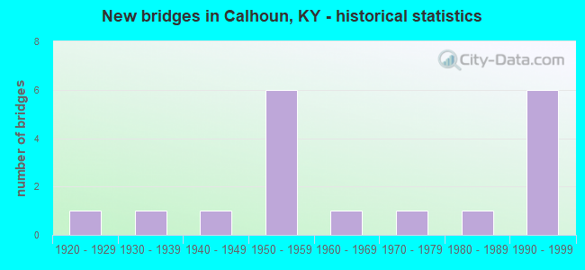
- New bridges - historical statistics
- 11920-1929
- 11930-1939
- 11940-1949
- 61950-1959
- 11960-1969
- 11970-1979
- 11980-1989
- 61990-1999


- Bridge Condition - Deck
- 7.7%Very good
- 7.7%Good
- 46.2%Satisfactory
- 38.5%Fair

- Bridge Condition - Superstructure
- 30.8%Good
- 46.2%Satisfactory
- 23.1%Fair

- Bridge Condition - Substructure
- 30.8%Good
- 53.8%Satisfactory
- 15.4%Fair

- Bridge Condition - Channel
- 6.3%Very good
- 56.3%Good
- 18.8%Satisfactory
- 12.5%Fair
- 6.3%Poor

- Bridge Condition - Culverts
- 33.3%Satisfactory
- 66.7%Fair
Find on map >> Show street view
Structure Number: 75B00001N, Location: .40 MI NOR. OF JCT KY 815 (Lat: 37.558333, Lng: -87.254444), Route carried "on" structure: State highway 81, Year Built: 1937, Status: Open, Structure Length: 0.88m (2.89ft), Average Daily Traffic: 3,802 (year 2018), Truck Traffic: 13%, Average Future Daily Traffic: 3,345 (year 2038), Design Load: H 15, Features Intersected: MYER CREEK
Minimum Vertical Clearance: 30+ m (98+ ft), Kilometerpoint: 21.737, Lanes on structure: 2, Owner: State Highway Agency, Approaching Roadway Width: 8.5m (27.9ft), Skew: 4 degrees, Material/Design: Concrete, Design/Construction: Culvert, Number Of Spans In Main Unit: 2, Length of Maximum Span: 4.0m (13.1ft)
Condition: Channel: Good, Culverts: Fair, Operating Rating: 83.6 metric tons, Method Used To Determine Operating Rating: Load Factor (LF), Inventory Rating: 50.1 metric tons, Method Used To Determine Inventory Rating: Load Factor (LF), Structural Evaluation: Somewhat better than minimum adequacy, Waterway Adequacy: Better than present minimum criteria, Approach Roadway Alignment: Equal to present desirable criteria, Designated Inspection Frequency: Every 24 months, Inspection Date: August 2020
Find on map >> Show street view
Structure Number: 75B00003N, Location: .80 MI EAST OF JCT KY 140 (Lat: 37.573056, Lng: -87.306111), Route carried "on" structure: State highway 1792, Year Built: 1959, Status: Posted for load, Structure Length: 3.05m (10.01ft), Average Daily Traffic: 58 (year 2018), Average Future Daily Traffic: 50 (year 2038), Design Load: H 15, Features Intersected: PORTERS DRAINAGE DITCH
Minimum Vertical Clearance: 30+ m (98+ ft), Kilometerpoint: 1.495, Lanes on structure: 2, Owner: State Highway Agency, Approaching Roadway Width: 4.6m (15.1ft), Skew: 3 degrees, Material/Design: Concrete, Design/Construction: Tee Beam, Number Of Spans In Main Unit: 3, Length of Maximum Span: 9.1m (29.9ft), Curb or Sidewalk Widths: Left: 0.3m (1.0ft), Right: 0.3m (1.0ft), Curb-To-Curb Width: 6.7m (22.0ft), Out-to-Out Width: 8.2m (26.9ft)
Condition: Deck: Satisfactory, Superstructure: Fair, Substructure: Satisfactory, Channel: Good, Operating Rating: 53.7 metric tons, Method Used To Determine Operating Rating: Load Factor (LF), Inventory Rating: 32.2 metric tons, Method Used To Determine Inventory Rating: Load Factor (LF), Structural Evaluation: Somewhat better than minimum adequacy, Deck Geometry: Somewhat better than minimum adequacy, Waterway Adequacy: Equal to present desirable criteria, Approach Roadway Alignment: Equal to present desirable criteria, Bridge Posting: Required (Relationship of Operating Rating to Maximum Legal Load: 30.0 - 39.9% below), Designated Inspection Frequency: Every 24 months, Inspection Date: August 2020, Deck Structure Type: Concrete Cast-file-Place, Wearing Surface/Protective System: Wearing Surface: Low Slump Concrete
Find on map >> Show street view
Structure Number: 75B00011N, Location: .20 MI EAST OF JCT KY 81 (Lat: 37.547222, Lng: -87.256111), Route carried "on" structure: State highway 136, Year Built: 1956, Status: Open, Structure Length: 1.10m (3.61ft), Average Daily Traffic: 3,076 (year 2019), Truck Traffic: 16%, Average Future Daily Traffic: 2,706 (year 2039), Design Load: H 15, Features Intersected: MYER CREEK
Minimum Vertical Clearance: 30+ m (98+ ft), Kilometerpoint: 16.240, Lanes on structure: 2, Owner: State Highway Agency, Approaching Roadway Width: 6.7m (22.0ft), Skew: 3 degrees, Material/Design: Concrete, Design/Construction: Culvert, Number Of Spans In Main Unit: 2, Length of Maximum Span: 4.9m (16.1ft), Curb-To-Curb Width: 7.9m (25.9ft), Out-to-Out Width: 8.5m (27.9ft)
Condition: Channel: Fair, Culverts: Fair, Operating Rating: 54.4 metric tons, Method Used To Determine Operating Rating: Field evaluation and documented engineering judgment, Inventory Rating: 39.9 metric tons, Method Used To Determine Inventory Rating: Field evaluation and documented engineering judgment, Structural Evaluation: Somewhat better than minimum adequacy, Deck Geometry: High priority of corrective action, Waterway Adequacy: Better than present minimum criteria, Approach Roadway Alignment: Equal to present desirable criteria, Designated Inspection Frequency: Every 24 months, Inspection Date: August 2020
Find on map >> Show street view
Structure Number: 75B00030N, Location: .40 MI WEST OF JCT KY 81 (Lat: 37.532500, Lng: -87.268333), Route carried "on" structure: State highway 256, Year Built: 1955, Status: Posted for load, Structure Length: 5.82m (19.09ft), Average Daily Traffic: 232 (year 2020), Average Future Daily Traffic: 204 (year 2040), Design Load: H 15, Features Intersected: LONG FALLS CREEK
Minimum Vertical Clearance: 30+ m (98+ ft), Kilometerpoint: 15.891, Lanes on structure: 2, Owner: State Highway Agency, Approaching Roadway Width: 5.5m (18.0ft), Skew: 3 degrees, Material/Design: Steel, Design/Construction: Stringer/Multi-beam, Number Of Spans In Main Unit: 3, Length of Maximum Span: 18.9m (62.0ft), Curb or Sidewalk Widths: Left: 0.8m (2.6ft), Right: 0.8m (2.6ft), Curb-To-Curb Width: 6.8m (22.3ft), Out-to-Out Width: 8.9m (29.2ft)
Condition: Deck: Fair, Superstructure: Satisfactory, Substructure: Fair, Channel: Satisfactory, Operating Rating: 33.3 metric tons, Method Used To Determine Operating Rating: Load Factor (LF), Inventory Rating: 20.0 metric tons, Method Used To Determine Inventory Rating: Load Factor (LF), Structural Evaluation: Somewhat better than minimum adequacy, Deck Geometry: Meets minimum limits, Waterway Adequacy: Equal to present desirable criteria, Approach Roadway Alignment: Better than present minimum criteria, Bridge Posting: Required (Relationship of Operating Rating to Maximum Legal Load: > 39.9% below), Designated Inspection Frequency: Every 24 months, Inspection Date: August 2020, Deck Structure Type: Concrete Cast-file-Place, Wearing Surface/Protective System: Wearing Surface: Low Slump Concrete
Find on map >> Show street view
Structure Number: 75B00034N, Location: 1.7 MI WEST OF JCT KY 81 (Lat: 37.563889, Lng: -87.275556), Route carried "on" structure: State highway 136, Year Built: 1928, Status: Open, Structure Length: 3.93m (12.89ft), Average Daily Traffic: 1,191 (year 2020), Truck Traffic: 16%, Average Future Daily Traffic: 1,048 (year 2040), Design Load: H 15, Features Intersected: LONG FALLS CREEK
Minimum Vertical Clearance: 30+ m (98+ ft), Kilometerpoint: 13.126, Lanes on structure: 2, Owner: State Highway Agency, Approaching Roadway Width: 5.5m (18.0ft), Material/Design: Concrete, Design/Construction: Tee Beam, Number Of Spans In Main Unit: 3, Length of Maximum Span: 12.2m (40.0ft), Curb or Sidewalk Widths: Left: 0.3m (1.0ft), Right: 0.3m (1.0ft), Curb-To-Curb Width: 5.5m (18.0ft), Out-to-Out Width: 6.7m (22.0ft)
Condition: Deck: Fair, Superstructure: Fair, Substructure: Satisfactory, Channel: Satisfactory, Operating Rating: 54.8 metric tons, Method Used To Determine Operating Rating: Load Factor (LF), Inventory Rating: 32.9 metric tons, Method Used To Determine Inventory Rating: Load Factor (LF), Structural Evaluation: Somewhat better than minimum adequacy, Deck Geometry: High priority of replacement, Waterway Adequacy: Equal to present minimum criteria, Approach Roadway Alignment: Equal to present minimum criteria, Length Of Structure Improvement: 0.39m (1.28ft), Designated Inspection Frequency: Every 24 months, Inspection Date: August 2020, Bridge Improvement Cost: $322,000, Total Project Cost: $322,000, Deck Structure Type: Concrete Cast-file-Place, Wearing Surface/Protective System: Wearing Surface: Low Slump Concrete
Find on map >> Show street view
Structure Number: 75B00042N, Location: .50 MI WEST OF JCT KY 815 (Lat: 37.604444, Lng: -87.263889), Route carried "on" structure: State highway 140, Year Built: 1941, Status: Open, Structure Length: 0.70m (2.30ft), Average Daily Traffic: 368 (year 2019), Average Future Daily Traffic: 323 (year 2039), Features Intersected: BR OFF LONG FALLS CREEK
Minimum Vertical Clearance: 30+ m (98+ ft), Kilometerpoint: 10.810, Lanes on structure: 2, Owner: State Highway Agency, Approaching Roadway Width: 5.6m (18.4ft), Material/Design: Concrete, Design/Construction: Culvert, Number Of Spans In Main Unit: 2, Length of Maximum Span: 3.0m (9.8ft)
Condition: Channel: Good, Culverts: Satisfactory, Operating Rating: 54.4 metric tons, Method Used To Determine Operating Rating: Field evaluation and documented engineering judgment, Inventory Rating: 39.9 metric tons, Method Used To Determine Inventory Rating: Field evaluation and documented engineering judgment, Structural Evaluation: Equal to present minimum criteria, Waterway Adequacy: Better than present minimum criteria, Approach Roadway Alignment: Equal to present desirable criteria, Designated Inspection Frequency: Every 24 months, Inspection Date: August 2020
Find on map >> Show street view
Structure Number: 75B00047N, Location: 1.0 MI SOU. OF JCT KY 140 (Lat: 37.589167, Lng: -87.256111), Route carried "on" structure: State highway 815, Year Built: 1958, Status: Posted for load, Structure Length: 3.47m (11.38ft), Average Daily Traffic: 657 (year 2019), Average Future Daily Traffic: 578 (year 2039), Design Load: H 15, Features Intersected: LONG FALLS CREEK
Minimum Vertical Clearance: 30+ m (98+ ft), Kilometerpoint: 4.551, Lanes on structure: 2, Owner: State Highway Agency, Approaching Roadway Width: 6.1m (20.0ft), Material/Design: Concrete, Design/Construction: Tee Beam, Number Of Spans In Main Unit: 3, Length of Maximum Span: 10.7m (35.1ft), Curb or Sidewalk Widths: Left: 0.3m (1.0ft), Right: 0.3m (1.0ft), Curb-To-Curb Width: 7.3m (24.0ft), Out-to-Out Width: 8.5m (27.9ft)
Condition: Deck: Satisfactory, Superstructure: Satisfactory, Substructure: Fair, Channel: Good, Operating Rating: 56.4 metric tons, Method Used To Determine Operating Rating: Load Factor (LF), Inventory Rating: 33.8 metric tons, Method Used To Determine Inventory Rating: Load Factor (LF), Structural Evaluation: Somewhat better than minimum adequacy, Deck Geometry: Meets minimum limits, Waterway Adequacy: Equal to present desirable criteria, Approach Roadway Alignment: Better than present minimum criteria, Bridge Posting: Required (Relationship of Operating Rating to Maximum Legal Load: 20.0 - 29.9% below), Designated Inspection Frequency: Every 24 months, Inspection Date: August 2020, Deck Structure Type: Concrete Cast-file-Place, Wearing Surface/Protective System: Wearing Surface: Low Slump Concrete
Find on map >> Show street view
Structure Number: 75B00048N, Location: 3.0 MI SOU. OF JCT KY 138 (Lat: 37.488889, Lng: -87.286389), Route carried "on" structure: State highway 1155, Year Built: 1967, Status: Open, Structure Length: 4.85m (15.91ft), Average Daily Traffic: 351 (year 2020), Average Future Daily Traffic: 308 (year 2040), Design Load: H 20, Features Intersected: CYPRESS CREEK
Minimum Vertical Clearance: 30+ m (98+ ft), Kilometerpoint: 7.409, Lanes on structure: 2, Owner: State Highway Agency, Approaching Roadway Width: 6.7m (22.0ft), Material/Design: Concrete, Design/Construction: Tee Beam, Number Of Spans In Main Unit: 3, Length of Maximum Span: 15.2m (49.9ft), Curb or Sidewalk Widths: Left: 0.3m (1.0ft), Right: 0.3m (1.0ft), Curb-To-Curb Width: 7.3m (24.0ft), Out-to-Out Width: 8.5m (27.9ft)
Condition: Deck: Satisfactory, Superstructure: Fair, Substructure: Satisfactory, Channel: Good, Operating Rating: 98.4 metric tons, Method Used To Determine Operating Rating: Load Factor (LF), Inventory Rating: 59.1 metric tons, Method Used To Determine Inventory Rating: Load Factor (LF), Structural Evaluation: Somewhat better than minimum adequacy, Deck Geometry: Somewhat better than minimum adequacy, Waterway Adequacy: Somewhat better than minimum adequacy, Approach Roadway Alignment: Better than present minimum criteria, Designated Inspection Frequency: Every 24 months, Inspection Date: August 2020, Deck Structure Type: Concrete Cast-file-Place, Wearing Surface/Protective System: Wearing Surface: Monolithic Concrete
Find on map >> Show street view
Structure Number: 75B00068N, Location: 3.6 MI W OF JCT KY 81 (Lat: 37.563889, Lng: -87.309444), Route carried "on" structure: State highway 256, Year Built: 1987, Status: Open, Structure Length: 2.07m (6.79ft), Average Daily Traffic: 242 (year 2019), Average Future Daily Traffic: 212 (year 2039), Design Load: HS 20, Features Intersected: PORTERS DITCH
Minimum Vertical Clearance: 30+ m (98+ ft), Kilometerpoint: 10.821, Lanes on structure: 2, Owner: State Highway Agency, Approaching Roadway Width: 6.1m (20.0ft), Material/Design: Prestressed concrete, Design/Construction: Box Beam or Girders - Multiple, Number Of Spans In Main Unit: 1, Length of Maximum Span: 19.5m (64.0ft), Curb-To-Curb Width: 8.2m (26.9ft), Out-to-Out Width: 8.7m (28.5ft)
Condition: Deck: Very good, Superstructure: Good, Substructure: Good, Channel: Good, Operating Rating: 60.6 metric tons, Method Used To Determine Operating Rating: Load Factor (LF), Inventory Rating: 36.4 metric tons, Method Used To Determine Inventory Rating: Load Factor (LF), Structural Evaluation: Better than present minimum criteria, Deck Geometry: Somewhat better than minimum adequacy, Waterway Adequacy: Equal to present minimum criteria, Approach Roadway Alignment: Equal to present desirable criteria, Designated Inspection Frequency: Every 24 months, Inspection Date: August 2020, Deck Structure Type: Concrete Precast Panels, Wearing Surface/Protective System: Wearing Surface: Bituminous, Membrane: Preformed Fabric, Deck Protection: Epoxy Coated Reinforcing
Find on map >> Show street view
Structure Number: 75B00074N, Location: 1.5 MI S JCT KY 1589 (Lat: 37.490278, Lng: -87.245278), Route carried "on" structure: State highway 81, Year Built: 1994, Status: Open, Structure Length: 4.24m (13.91ft), Average Daily Traffic: 1,514 (year 2018), Truck Traffic: 13%, Average Future Daily Traffic: 1,332 (year 2038), Design Load: HS 25 or greater, Features Intersected: CYPRESS CREEK
Minimum Vertical Clearance: 30+ m (98+ ft), Kilometerpoint: 13.464, Lanes on structure: 2, Owner: State Highway Agency, Approaching Roadway Width: 7.0m (23.0ft), Material/Design: Prestressed concrete continuous, Design/Construction: Stringer/Multi-beam, Number Of Spans In Main Unit: 3, Length of Maximum Span: 16.2m (53.1ft), Curb-To-Curb Width: 7.9m (25.9ft), Out-to-Out Width: 8.8m (28.9ft)
Condition: Deck: Fair, Superstructure: Good, Substructure: Satisfactory, Channel: Good, Operating Rating: 57.6 metric tons, Method Used To Determine Operating Rating: Load Factor (LF), Inventory Rating: 34.6 metric tons, Method Used To Determine Inventory Rating: Load Factor (LF), Structural Evaluation: Equal to present minimum criteria, Deck Geometry: Meets minimum limits, Waterway Adequacy: Equal to present desirable criteria, Approach Roadway Alignment: Better than present minimum criteria, Designated Inspection Frequency: Every 24 months, Inspection Date: August 2020, Deck Structure Type: Concrete Cast-file-Place, Wearing Surface/Protective System: Wearing Surface: Monolithic Concrete, Deck Protection: Epoxy Coated Reinforcing
Find on map >> Show street view
Structure Number: 75B00076N, Location: .2 MI N JCT KY 138 (Lat: 37.533889, Lng: -87.260833), Route carried "on" structure: State highway 81, Year Built: 1999, Status: Open, Structure Length: 34.69m (113.81ft), Average Daily Traffic: 4,053 (year 2019), Truck Traffic: 12%, Average Future Daily Traffic: 3,566 (year 2039), Design Load: HS 25 or greater, Features Intersected: KY256,GREEN RIVER, CANAL
Minimum Vertical Clearance: 5.92m (19.42ft), Kilometerpoint: 18.601, Lanes on structure: 2, Lanes under structure: 4, Owner: State Highway Agency, Approaching Roadway Width: 14.3m (46.9ft), Navigation Control: Yes ( Vertical Clearance: 21.1m (69.2ft), Horizontal Clearance: 110.6m (362.9ft)), Material/Design: Steel, Design/Construction: Truss - Thru, Number Of Spans In Main Unit: 1, Number Of Approach Spans: 5, Length of Maximum Span: 150.0m (492.1ft), Curb-To-Curb Width: 12.0m (39.4ft), Out-to-Out Width: 13.0m (42.7ft)
Condition: Deck: Good, Superstructure: Good, Substructure: Good, Channel: Very good, Operating Rating: 54.4 metric tons, Method Used To Determine Operating Rating: Load Factor (LF), Inventory Rating: 32.7 metric tons, Method Used To Determine Inventory Rating: Load Factor (LF), Structural Evaluation: Better than present minimum criteria, Deck Geometry: Somewhat better than minimum adequacy, Underclear: Superior to present desirable criteria, Waterway Adequacy: Equal to present desirable criteria, Approach Roadway Alignment: Equal to present minimum criteria, Designated Inspection Frequency: Every 24 months, Critical Feature Inspection Frequency: Every 24 months, Inspection Date: May 2020, Critical Feature Inspection Date: May 2020, Deck Structure Type: Concrete Cast-file-Place, Wearing Surface/Protective System: Wearing Surface: Monolithic Concrete, Deck Protection: Epoxy Coated Reinforcing
Find on map >> Show street view
Structure Number: 75C00008N, Location: .6 MI SE OF JCT CR 5300 (Lat: 37.581389, Lng: -87.277222), Route carried "on" structure: County highway 1200, Year Built: 1971, Status: Open, Structure Length: 2.62m (8.60ft), Average Daily Traffic: 32 (year 2012), Average Future Daily Traffic: 27 (year 2032), Design Load: HS 20, Features Intersected: LONG FALLS CREEK, Facility Carried by Structure: SCOTTS BRIDGE ROAD
Minimum Vertical Clearance: 30+ m (98+ ft), Kilometerpoint: 3.112, Lanes on structure: 2, Owner: County Highway Agency, Approaching Roadway Width: 4.9m (16.1ft), Material/Design: Prestressed concrete, Design/Construction: Box Beam or Girders - Multiple, Number Of Spans In Main Unit: 3, Length of Maximum Span: 11.9m (39.0ft), Curb or Sidewalk Widths: Left: 0.1m (0.3ft), Right: 0.1m (0.3ft), Curb-To-Curb Width: 6.9m (22.6ft), Out-to-Out Width: 7.4m (24.3ft)
Condition: Deck: Satisfactory, Superstructure: Good, Substructure: Satisfactory, Channel: Satisfactory, Operating Rating: 65.6 metric tons, Method Used To Determine Operating Rating: Load Factor (LF), Inventory Rating: 39.4 metric tons, Method Used To Determine Inventory Rating: Load Factor (LF), Structural Evaluation: Equal to present minimum criteria, Deck Geometry: Somewhat better than minimum adequacy, Waterway Adequacy: Meets minimum limits, Approach Roadway Alignment: Meets minimum limits, Designated Inspection Frequency: Every 24 months, Inspection Date: Febuary 2020, Deck Structure Type: Concrete Precast Panels, Wearing Surface/Protective System: Wearing Surface: Monolithic Concrete
Find on map >> Show street view
Structure Number: 75C00016N, Location: .4 MI E OF JCT KY81 (Lat: 37.536389, Lng: -87.251667), Route carried "on" structure: County highway 1004, Year Built: 1958, Status: Posted for load, Structure Length: 5.24m (17.19ft), Average Daily Traffic: 192 (year 2012), Average Future Daily Traffic: 167 (year 2032), Design Load: H 15, Features Intersected: MYERS CREEK, Facility Carried by Structure: RICHLAND ROAD
Minimum Vertical Clearance: 30+ m (98+ ft), Kilometerpoint: 11.803, Lanes on structure: 2, Owner: County Highway Agency, Approaching Roadway Width: 5.5m (18.0ft), Skew: 4 degrees, Material/Design: Concrete, Design/Construction: Tee Beam, Number Of Spans In Main Unit: 4, Length of Maximum Span: 13.1m (43.0ft), Curb or Sidewalk Widths: Left: 0.3m (1.0ft), Right: 0.3m (1.0ft), Curb-To-Curb Width: 7.3m (24.0ft), Out-to-Out Width: 8.5m (27.9ft)
Condition: Deck: Fair, Superstructure: Satisfactory, Substructure: Good, Channel: Good, Operating Rating: 54.6 metric tons, Method Used To Determine Operating Rating: Load Factor (LF), Inventory Rating: 32.7 metric tons, Method Used To Determine Inventory Rating: Load Factor (LF), Structural Evaluation: Equal to present minimum criteria, Deck Geometry: Somewhat better than minimum adequacy, Waterway Adequacy: Meets minimum limits, Approach Roadway Alignment: Equal to present desirable criteria, Bridge Posting: Required (Relationship of Operating Rating to Maximum Legal Load: 10.0 - 19.9% below), Designated Inspection Frequency: Every 24 months, Inspection Date: Febuary 2020, Deck Structure Type: Concrete Cast-file-Place, Wearing Surface/Protective System: Wearing Surface: Monolithic Concrete
Find on map >> Show street view
Structure Number: 75C00023N, Location: .6 MI W KY 1589 (Lat: 37.500556, Lng: -87.222500), Route carried "on" structure: County highway 1002, Year Built: 1991, Status: Open, Structure Length: 1.04m (3.41ft), Average Daily Traffic: 4 (year 2012), Average Future Daily Traffic: 3 (year 2032), Design Load: HS 25 or greater, Features Intersected: TRIB-CYPRESS CREEK, Facility Carried by Structure: BUNN-COBB ROAD
Minimum Vertical Clearance: 30+ m (98+ ft), Kilometerpoint: 2.779, Lanes on structure: 2, Owner: County Highway Agency, Approaching Roadway Width: 4.6m (15.1ft), Material/Design: Prestressed concrete, Design/Construction: Box Beam or Girders - Multiple, Number Of Spans In Main Unit: 1, Length of Maximum Span: 9.1m (29.9ft), Curb or Sidewalk Widths: Left: 0.1m (0.3ft), Right: 0.1m (0.3ft), Curb-To-Curb Width: 6.9m (22.6ft), Out-to-Out Width: 7.4m (24.3ft)
Condition: Deck: Satisfactory, Superstructure: Satisfactory, Substructure: Good, Channel: Good, Operating Rating: 65.4 metric tons, Method Used To Determine Operating Rating: Load Factor (LF), Inventory Rating: 39.3 metric tons, Method Used To Determine Inventory Rating: Load Factor (LF), Structural Evaluation: Equal to present minimum criteria, Deck Geometry: Somewhat better than minimum adequacy, Waterway Adequacy: Meets minimum limits, Approach Roadway Alignment: Equal to present desirable criteria, Designated Inspection Frequency: Every 24 months, Inspection Date: Febuary 2020, Deck Structure Type: Concrete Precast Panels, Wearing Surface/Protective System: Wearing Surface: Monolithic Concrete, Deck Protection: Epoxy Coated Reinforcing
Find on map >> Show street view
Structure Number: 75C00024N, Location: 2.2 MI W KY 81 (Lat: 37.482222, Lng: -87.278611), Route carried "on" structure: County highway 1236, Year Built: 1991, Status: Open, Structure Length: 1.22m (4.00ft), Average Daily Traffic: 10 (year 2012), Average Future Daily Traffic: 8 (year 2032), Design Load: HS 25 or greater, Features Intersected: POND DRAIN, Facility Carried by Structure: POND DRAIN ROAD
Minimum Vertical Clearance: 30+ m (98+ ft), Kilometerpoint: 1.392, Lanes on structure: 2, Owner: County Highway Agency, Approaching Roadway Width: 4.3m (14.1ft), Material/Design: Prestressed concrete, Design/Construction: Box Beam or Girders - Multiple, Number Of Spans In Main Unit: 1, Length of Maximum Span: 11.0m (36.1ft), Curb or Sidewalk Widths: Left: 0.1m (0.3ft), Right: 0.1m (0.3ft), Curb-To-Curb Width: 6.9m (22.6ft), Out-to-Out Width: 7.4m (24.3ft)
Condition: Deck: Satisfactory, Superstructure: Satisfactory, Substructure: Satisfactory, Channel: Poor, Operating Rating: 69.1 metric tons, Method Used To Determine Operating Rating: Load Factor (LF), Inventory Rating: 41.5 metric tons, Method Used To Determine Inventory Rating: Load Factor (LF), Structural Evaluation: Equal to present minimum criteria, Deck Geometry: Somewhat better than minimum adequacy, Waterway Adequacy: Meets minimum limits, Approach Roadway Alignment: Equal to present desirable criteria, Designated Inspection Frequency: Every 24 months, Inspection Date: Febuary 2020, Deck Structure Type: Concrete Precast Panels, Wearing Surface/Protective System: Wearing Surface: Monolithic Concrete, Deck Protection: Epoxy Coated Reinforcing
Find on map >> Show street view
Structure Number: 75C00029N, Location: 2.1 MI S.W. OF JCT KY 138 (Lat: 37.509167, Lng: -87.316667), Route carried "on" structure: County highway 1210, Year Built: 1955, Status: Posted for load, Structure Length: 8.11m (26.61ft), Average Daily Traffic: 24 (year 2012), Average Future Daily Traffic: 20 (year 2032), Design Load: H 15, Features Intersected: CYPRESS CREEK
Minimum Vertical Clearance: 30+ m (98+ ft), Kilometerpoint: 7.992, Lanes on structure: 2, Owner: County Highway Agency, Approaching Roadway Width: 6.1m (20.0ft), Material/Design: Concrete, Design/Construction: Tee Beam, Number Of Spans In Main Unit: 7, Length of Maximum Span: 10.7m (35.1ft), Curb or Sidewalk Widths: Left: 0.3m (1.0ft), Right: 0.3m (1.0ft), Curb-To-Curb Width: 6.7m (22.0ft), Out-to-Out Width: 7.3m (24.0ft)
Condition: Deck: Fair, Superstructure: Satisfactory, Substructure: Satisfactory, Channel: Fair, Operating Rating: 47.1 metric tons, Method Used To Determine Operating Rating: Load Factor (LF), Inventory Rating: 28.2 metric tons, Method Used To Determine Inventory Rating: Load Factor (LF), Structural Evaluation: Equal to present minimum criteria, Deck Geometry: Somewhat better than minimum adequacy, Waterway Adequacy: Somewhat better than minimum adequacy, Approach Roadway Alignment: Equal to present desirable criteria, Bridge Posting: Required (Relationship of Operating Rating to Maximum Legal Load: 30.0 - 39.9% below), Designated Inspection Frequency: Every 24 months, Inspection Date: Febuary 2020, Deck Structure Type: Concrete Cast-file-Place, Wearing Surface/Protective System: Wearing Surface: Bituminous, Membrane: Preformed Fabric
Find on map >> Show street view
Structure Number: 75B00076N, Location: .2 MI N JCT KY 138 (Lat: 37.533889, Lng: -87.260833), Route carried "under" structure: State highway 256, Year Built: 1999, Structure Length: 0. m, Average Daily Traffic: 232 (year 2020), Features Intersected: KY256,GREEN RIVER, CANAL, Facility Carried by Structure: KY-81
Minimum Vertical Clearance: 9.36m (30.71ft), Kilometerpoint: 16.591, Lanes on structure: 2, Lanes under structure: 2, Material/Design: Steel, Design/Construction: Truss - Thru, Length of Maximum Span: 150.0m (492.1ft)
Find on map >> Show street view
Structure Number: 75B00076N, Location: .2 MI N JCT KY 138 (Lat: 37.533889, Lng: -87.260833), Route carried "under" structure: County highway 1043, Year Built: 1999, Structure Length: 0. m, Features Intersected: KY256,GREEN RIVER, CANAL, Facility Carried by Structure: KY-81
Minimum Vertical Clearance: 10.22m (33.53ft), Kilometerpoint: 0.021, Lanes on structure: 2, Lanes under structure: 2, Material/Design: Steel, Design/Construction: Truss - Thru, Length of Maximum Span: 150.0m (492.1ft)