Bridge Statistics for Cambridge Springs, Pennsylvania (PA)
Condition, Traffic, Stress, Structural Evaluation, Project Costs
- National Bridge Inventory (NBI) Statistics
- 14Number of bridges
- 118ft / 35.6mTotal length
- $1,916,000Total costs
- 24,613Total average daily traffic
- 1,293Total average daily truck traffic
- 35,333Total future (year 2032) average daily traffic
- National Bridge Inventory (NBI) Registered Bridges for Cambridge Springs
- No street view available for this location
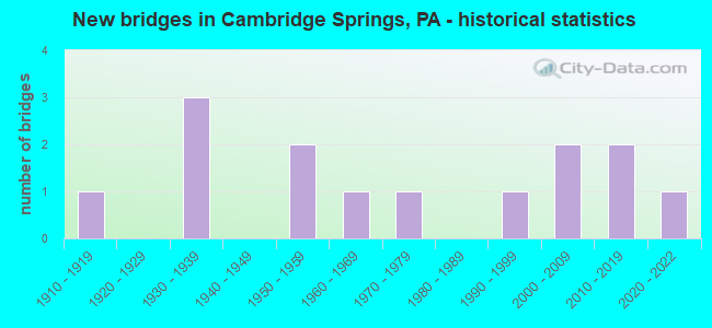
- New bridges - historical statistics
- 11910-1919
- 31930-1939
- 21950-1959
- 11960-1969
- 11970-1979
- 11990-1999
- 22000-2009
- 22010-2019
- 12020-2022
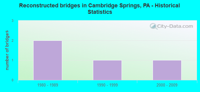
- Reconstructed bridges - Historical Statistics
- 21980-1989
- 11990-1999
- 12000-2009
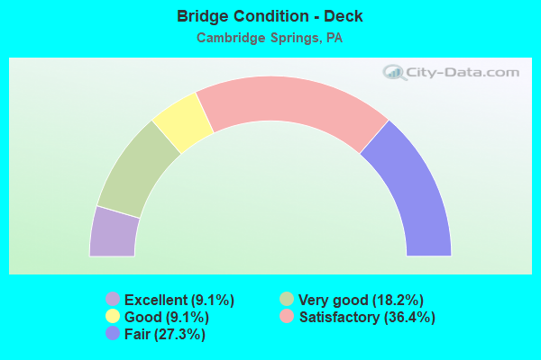
- Bridge Condition - Deck
- 9.1%Excellent
- 18.2%Very good
- 9.1%Good
- 36.4%Satisfactory
- 27.3%Fair
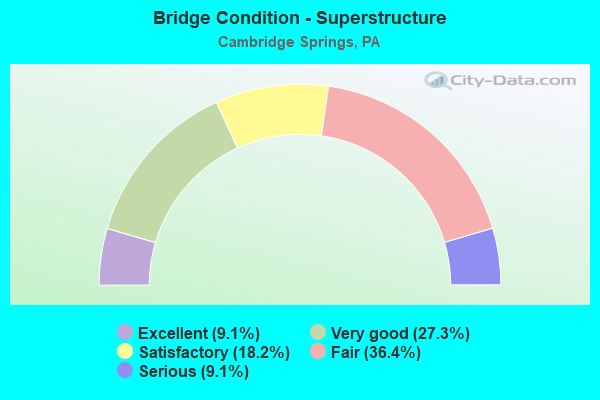
- Bridge Condition - Superstructure
- 9.1%Excellent
- 27.3%Very good
- 18.2%Satisfactory
- 36.4%Fair
- 9.1%Serious
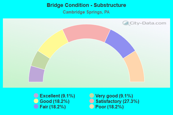
- Bridge Condition - Substructure
- 9.1%Excellent
- 9.1%Very good
- 18.2%Good
- 27.3%Satisfactory
- 18.2%Fair
- 18.2%Poor
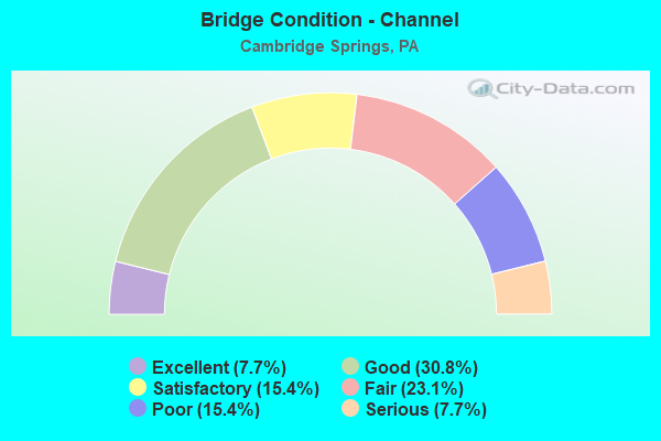
- Bridge Condition - Channel
- 7.7%Excellent
- 30.8%Good
- 15.4%Satisfactory
- 23.1%Fair
- 15.4%Poor
- 7.7%Serious
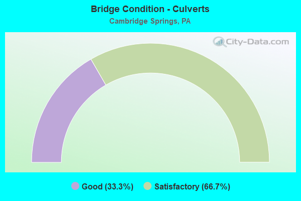
- Bridge Condition - Culverts
- 33.3%Good
- 66.7%Satisfactory
Find on map >> Show street view
Structure Number: 12901, Location: CAMBRIDGE TOWNSHIP (Lat: 41.794114, Lng: -80.084667), Route carried "on" structure: US 6, Year Built: 1967, Status: Open, Structure Length: 0.64m (2.10ft), Average Daily Traffic: 2,357 (year 2021), Truck Traffic: 14%, Average Future Daily Traffic: 4,622 (year 2032), Design Load: HS 20, Features Intersected: OVER FRENCH CREEK TRIB
Minimum Vertical Clearance: 30+ m (98+ ft), Kilometerpoint: 58.461, Lanes on structure: 2, Base Highway Network: Yes, Owner: State Highway Agency, Approaching Roadway Width: 9.1m (29.9ft), Skew: 2 degrees, Material/Design: Steel, Design/Construction: Culvert, Number Of Spans In Main Unit: 1, Length of Maximum Span: 6.4m (21.0ft)
Condition: Channel: Satisfactory, Culverts: Satisfactory, Operating Rating: 49.0 metric tons, Method Used To Determine Operating Rating: Field evaluation and documented engineering judgment, Inventory Rating: 32.7 metric tons, Method Used To Determine Inventory Rating: Field evaluation and documented engineering judgment, Structural Evaluation: Equal to present minimum criteria, Waterway Adequacy: Superior to present desirable criteria, Approach Roadway Alignment: Equal to present desirable criteria, Length Of Structure Improvement: 0.60m (1.97ft), Designated Inspection Frequency: Every 24 months, Inspection Date: July 2021, Bridge Improvement Cost: $13,000, Roadway Improvement Cost: $49,000, Total Project Cost: $173,000
Find on map >> Show street view
Structure Number: 13055, Location: CAMBRIDGE TOWNSHIP (Lat: 41.829467, Lng: -80.083683), Route carried "on" structure: State highway 99, Year Built: 1930, Year Reconstructed: 1985, Status: Open, Structure Length: 2.93m (9.61ft), Average Daily Traffic: 2,985 (year 2022), Truck Traffic: 5%, Average Future Daily Traffic: 3,590 (year 2032), Design Load: H 20, Features Intersected: OVER CONNEAUT CREEK
Minimum Vertical Clearance: 30+ m (98+ ft), Kilometerpoint: 3.647, Lanes on structure: 2, Base Highway Network: Yes, Owner: State Highway Agency, Approaching Roadway Width: 7.9m (25.9ft), Material/Design: Steel, Design/Construction: Girder and Floorbeam System, Number Of Spans In Main Unit: 1, Length of Maximum Span: 28.3m (92.8ft), Curb-To-Curb Width: 9.1m (29.9ft), Out-to-Out Width: 10.4m (34.1ft)
Condition: Deck: Satisfactory, Superstructure: Fair, Substructure: Fair, Channel: Good, Operating Rating: 45.4 metric tons, Method Used To Determine Operating Rating: Load Factor (LF), Inventory Rating: 27.2 metric tons, Method Used To Determine Inventory Rating: Load Factor (LF), Structural Evaluation: Somewhat better than minimum adequacy, Deck Geometry: Meets minimum limits, Waterway Adequacy: Equal to present minimum criteria, Approach Roadway Alignment: Somewhat better than minimum adequacy, Length Of Structure Improvement: 2.90m (9.51ft), Designated Inspection Frequency: Every 24 months, Critical Feature Inspection Frequency: Every 24 months, Inspection Date: August 2020, Critical Feature Inspection Date: August 2020, Bridge Improvement Cost: $22,000, Roadway Improvement Cost: $64,000, Total Project Cost: $294,000, Deck Structure Type: Concrete Cast-file-Place, Wearing Surface/Protective System: Wearing Surface: Bituminous, Membrane: Preformed Fabric
Find on map >> Show street view
Structure Number: 13117, Location: ROCKDALE TOWNSHIP (Lat: 41.782933, Lng: -80.002794), Route carried "on" structure: State highway 408, Year Built: 1930, Status: Open, Structure Length: 1.10m (3.61ft), Average Daily Traffic: 1,012 (year 2022), Truck Traffic: 5%, Average Future Daily Traffic: 1,958 (year 2032), Design Load: H 20, Features Intersected: OVER MOHAWK RUN
Minimum Vertical Clearance: 30+ m (98+ ft), Kilometerpoint: 5.153, Lanes on structure: 2, Owner: State Highway Agency, Approaching Roadway Width: 7.9m (25.9ft), Skew: 3 degrees, Material/Design: Concrete, Design/Construction: Tee Beam, Number Of Spans In Main Unit: 1, Length of Maximum Span: 10.1m (33.1ft), Curb or Sidewalk Widths: Left: 0.2m (0.7ft), Right: 0.2m (0.7ft), Curb-To-Curb Width: 8.8m (28.9ft), Out-to-Out Width: 9.4m (30.8ft)
Condition: Deck: Fair, Superstructure: Fair, Substructure: Fair, Channel: Fair, Operating Rating: 49.9 metric tons, Method Used To Determine Operating Rating: Load Factor (LF), Inventory Rating: 29.0 metric tons, Method Used To Determine Inventory Rating: Load Factor (LF), Structural Evaluation: Somewhat better than minimum adequacy, Deck Geometry: Somewhat better than minimum adequacy, Waterway Adequacy: Equal to present desirable criteria, Approach Roadway Alignment: Equal to present desirable criteria, Length Of Structure Improvement: 1.70m (5.58ft), Designated Inspection Frequency: Every 24 months, Inspection Date: Febuary 2020, Bridge Improvement Cost: $13,000, Roadway Improvement Cost: $37,000, Total Project Cost: $170,000, Wearing Surface/Protective System: Wearing Surface: Bituminous, Membrane: Preformed Fabric
Find on map >> Show street view
Structure Number: 13169, Location: ROCKDALE TOWNSHIP (Lat: 41.800478, Lng: -80.006344), Route carried "on" structure: State highway , Year Built: 1996, Status: Open, Structure Length: 0.91m (2.99ft), Average Daily Traffic: 405 (year 2017), Truck Traffic: 10%, Average Future Daily Traffic: 567 (year 2032), Design Load: HS 25 or greater, Features Intersected: OVER MOHAWK RUN, Facility Carried by Structure: SR 1014,JOHNSTOWN
Minimum Vertical Clearance: 30+ m (98+ ft), Kilometerpoint: 1.062, Lanes on structure: 2, Owner: State Highway Agency, Approaching Roadway Width: 8.5m (27.9ft), Material/Design: Concrete, Design/Construction: Culvert, Number Of Spans In Main Unit: 2, Length of Maximum Span: 4.3m (14.1ft)
Condition: Channel: Fair, Culverts: Satisfactory, Inventory Rating: 61.7 metric tons, Method Used To Determine Inventory Rating: Load Factor (LF), Structural Evaluation: Equal to present minimum criteria, Waterway Adequacy: Superior to present desirable criteria, Approach Roadway Alignment: Equal to present desirable criteria, Length Of Structure Improvement: 1.60m (5.25ft), Designated Inspection Frequency: Every 48 months, Inspection Date: November 2020
Find on map >> Show street view
Structure Number: 13191, Location: VENANGO TOWNSHIP (Lat: 41.799328, Lng: -80.093444), Route carried "on" structure: State highway , Year Built: 1957, Status: Open, Structure Length: 1.55m (5.09ft), Average Daily Traffic: 1,729 (year 2022), Truck Traffic: 2%, Average Future Daily Traffic: 1,883 (year 2032), Design Load: HS 20, Features Intersected: OVER BOLES RUN, Facility Carried by Structure: SR 1019,OLD PLANK
Minimum Vertical Clearance: 30+ m (98+ ft), Kilometerpoint: 3.103, Lanes on structure: 2, Owner: State Highway Agency, Approaching Roadway Width: 6.7m (22.0ft), Material/Design: Steel, Design/Construction: Stringer/Multi-beam, Number Of Spans In Main Unit: 1, Length of Maximum Span: 14.9m (48.9ft), Curb or Sidewalk Widths: Left: 0.2m (0.7ft), Right: 0.2m (0.7ft), Curb-To-Curb Width: 10.4m (34.1ft), Out-to-Out Width: 11.3m (37.1ft)
Condition: Deck: Satisfactory, Superstructure: Fair, Substructure: Satisfactory, Channel: Satisfactory, Operating Rating: 42.6 metric tons, Method Used To Determine Operating Rating: Load Factor (LF), Inventory Rating: 25.4 metric tons, Method Used To Determine Inventory Rating: Load Factor (LF), Structural Evaluation: Somewhat better than minimum adequacy, Deck Geometry: Equal to present minimum criteria, Waterway Adequacy: Equal to present minimum criteria, Approach Roadway Alignment: Equal to present desirable criteria, Length Of Structure Improvement: 2.20m (7.22ft), Designated Inspection Frequency: Every 24 months, Inspection Date: September 2021, Deck Structure Type: Concrete Cast-file-Place, Wearing Surface/Protective System: Wearing Surface: Bituminous
Find on map >> Show street view
Structure Number: 135, Location: .5 MI S SR 1006 (Lat: 41.805572, Lng: -80.099231), Route carried "on" structure: City street 7229, Year Built: 1972, Status: Posted for load, Structure Length: 1.55m (5.09ft), Average Daily Traffic: 250 (year 2020), Truck Traffic: 1%, Average Future Daily Traffic: 350 (year 2040), Design Load: HS 20, Features Intersected: OVER BOLE'S RUN, Facility Carried by Structure: T-847 (TOBIN ROAD)
Minimum Vertical Clearance: 30+ m (98+ ft), Kilometerpoint: 0.000, Lanes on structure: 2, Owner: County Highway Agency, Approaching Roadway Width: 8.5m (27.9ft), Material/Design: Prestressed concrete, Design/Construction: Box Beam or Girders - Multiple, Number Of Spans In Main Unit: 1, Length of Maximum Span: 15.2m (49.9ft), Curb or Sidewalk Widths: Left: 0.2m (0.7ft), Right: 0.2m (0.7ft), Curb-To-Curb Width: 9.1m (29.9ft), Out-to-Out Width: 10.4m (34.1ft)
Condition: Deck: Fair, Superstructure: Serious, Substructure: Satisfactory, Channel: Serious, Operating Rating: 66.2 metric tons, Method Used To Determine Operating Rating: Load Factor (LF), Inventory Rating: 12.7 metric tons, Method Used To Determine Inventory Rating: Load Factor (LF), Structural Evaluation: High priority of corrective action, Deck Geometry: Equal to present minimum criteria, Waterway Adequacy: Superior to present desirable criteria, Approach Roadway Alignment: Equal to present desirable criteria, Length Of Structure Improvement: 2.00m (6.56ft), Designated Inspection Frequency: Every 24 months, Other Special Inspection Frequency: Every 12 months, Inspection Date: April 2020, Other Special Inspection Date: April 2021, Bridge Improvement Cost: $52,000, Roadway Improvement Cost: $264,000, Total Project Cost: $704,000, Deck Structure Type: Other, Wearing Surface/Protective System: Wearing Surface: Bituminous
Find on map >> Show street view
Structure Number: 13501, Location: 4 MI. N. VENANGO (Lat: 41.827517, Lng: -80.093450), Route carried "on" structure: City street 7229, Year Built: 1915, Year Reconstructed: 1990, Status: Open, Structure Length: 0.67m (2.20ft), Average Daily Traffic: 250 (year 2020), Truck Traffic: 1%, Average Future Daily Traffic: 350 (year 2040), Features Intersected: OVER TORRY RUN, Facility Carried by Structure: T-873,RACOP ROAD
Minimum Vertical Clearance: 30+ m (98+ ft), Kilometerpoint: 0.000, Lanes on structure: 1, Owner: Town or Township Highway Agency, Approaching Roadway Width: 3.0m (9.8ft), Material/Design: Concrete continuous, Design/Construction: Stringer/Multi-beam, Number Of Spans In Main Unit: 1, Length of Maximum Span: 6.4m (21.0ft), Curb or Sidewalk Widths: Left: 0.4m (1.3ft), Right: 0.4m (1.3ft), Curb-To-Curb Width: 4.8m (15.7ft), Out-to-Out Width: 5.5m (18.0ft)
Condition: Deck: Fair, Superstructure: Fair, Substructure: Poor, Channel: Poor, Operating Rating: 49.0 metric tons, Method Used To Determine Operating Rating: Field evaluation and documented engineering judgment, Inventory Rating: 32.7 metric tons, Method Used To Determine Inventory Rating: Field evaluation and documented engineering judgment, Structural Evaluation: Meets minimum limits, Deck Geometry: High priority of corrective action, Waterway Adequacy: Meets minimum limits, Approach Roadway Alignment: Somewhat better than minimum adequacy, Length Of Structure Improvement: 0.90m (2.95ft), Designated Inspection Frequency: Every 24 months, Inspection Date: May 2020, Deck Structure Type: Concrete Cast-file-Place, Wearing Surface/Protective System: Wearing Surface: Monolithic Concrete
Find on map >> Show street view
Structure Number: 36453, Location: SALEM TOWNSHIP (Lat: 40.436247, Lng: -79.545653), Route carried "on" structure: State highway , Year Built: 1930, Year Reconstructed: 1987, Status: Open, Structure Length: 1.25m (4.10ft), Average Daily Traffic: 674 (year 2021), Truck Traffic: 3%, Average Future Daily Traffic: 795 (year 2032), Design Load: HS 20+Mod, Features Intersected: BEAVER RUN, Facility Carried by Structure: SR 1061
Minimum Vertical Clearance: 30+ m (98+ ft), Kilometerpoint: 4.085, Lanes on structure: 2, Owner: State Highway Agency, Approaching Roadway Width: 5.8m (19.0ft), Material/Design: Concrete, Design/Construction: Slab, Number Of Spans In Main Unit: 2, Length of Maximum Span: 5.8m (19.0ft), Curb-To-Curb Width: 7.1m (23.3ft), Out-to-Out Width: 8.3m (27.2ft)
Condition: Deck: Satisfactory, Superstructure: Satisfactory, Substructure: Poor, Channel: Poor, Operating Rating: 87.1 metric tons, Method Used To Determine Operating Rating: Load Factor (LF), Inventory Rating: 51.7 metric tons, Method Used To Determine Inventory Rating: Load Factor (LF), Structural Evaluation: Meets minimum limits, Deck Geometry: Meets minimum limits, Waterway Adequacy: Superior to present desirable criteria, Approach Roadway Alignment: Equal to present desirable criteria, Length Of Structure Improvement: 1.90m (6.23ft), Designated Inspection Frequency: Every 24 months, Inspection Date: December 2019, Bridge Improvement Cost: $43,000, Roadway Improvement Cost: $125,000, Total Project Cost: $575,000, Wearing Surface/Protective System: Wearing Surface: Bituminous
Find on map >> Show street view
Structure Number: 36543, Location: ROSTRAVER TOWNSHIP (Lat: 40.141986, Lng: -79.819758), Route carried "on" structure: State highway , Year Built: 1958, Year Reconstructed: 2011, Status: Open, Structure Length: 5.00m (16.40ft), Average Daily Traffic: 3,514 (year 2022), Truck Traffic: 6%, Average Future Daily Traffic: 3,680 (year 2032), Design Load: HS 20+Mod, Features Intersected: Wheeling & Lake Erie R/R, Facility Carried by Structure: SR 3011
Minimum Vertical Clearance: 30+ m (98+ ft), Kilometerpoint: 1.617, Lanes on structure: 2, Owner: State Highway Agency, Approaching Roadway Width: 9.1m (29.9ft), Skew: 4 degrees, Material/Design: Steel continuous, Design/Construction: Stringer/Multi-beam, Number Of Spans In Main Unit: 3, Length of Maximum Span: 16.2m (53.1ft), Curb or Sidewalk Widths: Left: 0.3m (1.0ft), Right: 0.3m (1.0ft), Curb-To-Curb Width: 9.8m (32.2ft), Out-to-Out Width: 11.1m (36.4ft)
Condition: Deck: Satisfactory, Superstructure: Satisfactory, Substructure: Satisfactory, Operating Rating: 59.9 metric tons, Method Used To Determine Operating Rating: Load Factor (LF), Inventory Rating: 35.4 metric tons, Method Used To Determine Inventory Rating: Load Factor (LF), Structural Evaluation: Equal to present minimum criteria, Deck Geometry: Meets minimum limits, Underclear: High priority of corrective action, Approach Roadway Alignment: Better than present minimum criteria, Length Of Structure Improvement: 5.90m (19.36ft), Designated Inspection Frequency: Every 24 months, Inspection Date: May 2021, Deck Structure Type: Concrete Cast-file-Place, Wearing Surface/Protective System: Wearing Surface: Latex Concrete
Find on map >> Show street view
Structure Number: 41934, Location: CAMBRIDGE SPRINGS BOROUGH (Lat: 41.806456, Lng: -80.061350), Route carried "on" structure: State highway , Year Built: 2003, Status: Open, Structure Length: 6.34m (20.80ft), Average Daily Traffic: 1,974 (year 2022), Truck Traffic: 3%, Average Future Daily Traffic: 2,546 (year 2032), Design Load: HS 25 or greater, Features Intersected: OVER FRENCH CREEK, Facility Carried by Structure: SR 1025,GRANT ST.
Minimum Vertical Clearance: 30+ m (98+ ft), Kilometerpoint: 0.000, Lanes on structure: 2, Owner: State Highway Agency, Approaching Roadway Width: 8.5m (27.9ft), Material/Design: Prestressed concrete continuous, Design/Construction: Box Beam or Girders - Multiple, Number Of Spans In Main Unit: 2, Length of Maximum Span: 31.7m (104.0ft), Curb or Sidewalk Widths: Left: 0.0m, Right: 1.7m (5.6ft), Curb-To-Curb Width: 8.9m (29.2ft), Out-to-Out Width: 11.3m (37.1ft)
Condition: Deck: Good, Superstructure: Very good, Substructure: Good, Channel: Good, Operating Rating: 80.7 metric tons, Method Used To Determine Operating Rating: Load Factor (LF), Inventory Rating: 42.6 metric tons, Method Used To Determine Inventory Rating: Load Factor (LF), Structural Evaluation: Better than present minimum criteria, Deck Geometry: Somewhat better than minimum adequacy, Waterway Adequacy: Superior to present desirable criteria, Approach Roadway Alignment: Equal to present desirable criteria, Length Of Structure Improvement: 7.30m (23.95ft), Designated Inspection Frequency: Every 48 months, Underwater Inspection Frequency: Every 60 months, Inspection Date: October 2020, Underwater Inspection Date: October 2017, Deck Structure Type: Concrete Cast-file-Place, Wearing Surface/Protective System: Wearing Surface: Monolithic Concrete, Deck Protection: Epoxy Coated Reinforcing
Find on map >> Show street view
Structure Number: 42019, Location: CAMBRIDGE TOWNSHIP (Lat: 41.820564, Lng: -80.064469), Route carried "on" structure: State highway 99, Year Built: 2003, Status: Open, Structure Length: 3.20m (10.50ft), Average Daily Traffic: 2,985 (year 2022), Truck Traffic: 5%, Average Future Daily Traffic: 3,590 (year 2032), Design Load: HS 25 or greater, Features Intersected: OVER LITTLE CONNEAUTTEE
Minimum Vertical Clearance: 30+ m (98+ ft), Kilometerpoint: 1.942, Lanes on structure: 2, Base Highway Network: Yes, Owner: State Highway Agency, Approaching Roadway Width: 10.4m (34.1ft), Material/Design: Prestressed concrete, Design/Construction: Box Beam or Girders - Single/Spread, Number Of Spans In Main Unit: 1, Length of Maximum Span: 30.8m (101.0ft), Curb or Sidewalk Widths: Left: 0.2m (0.7ft), Right: 0.2m (0.7ft), Curb-To-Curb Width: 12.3m (40.4ft), Out-to-Out Width: 13.2m (43.3ft)
Condition: Deck: Very good, Superstructure: Very good, Substructure: Very good, Channel: Good, Operating Rating: 75.3 metric tons, Method Used To Determine Operating Rating: Load Factor (LF), Inventory Rating: 36.3 metric tons, Method Used To Determine Inventory Rating: Load Factor (LF), Structural Evaluation: Equal to present desirable criteria, Deck Geometry: Equal to present minimum criteria, Waterway Adequacy: Superior to present desirable criteria, Approach Roadway Alignment: Equal to present desirable criteria, Length Of Structure Improvement: 3.90m (12.80ft), Designated Inspection Frequency: Every 24 months, Inspection Date: August 2020, Deck Structure Type: Concrete Cast-file-Place, Wearing Surface/Protective System: Wearing Surface: Bituminous, Deck Protection: Epoxy Coated Reinforcing
Find on map >> Show street view
Structure Number: 46597, Location: 2.5 mi N Cambridge Spring (Lat: 41.837092, Lng: -80.062631), Route carried "on" structure: Other road 899, Year Built: 2011, Status: Open, Structure Length: 3.29m (10.79ft), Average Daily Traffic: 250 (year 2021), Truck Traffic: 1%, Average Future Daily Traffic: 250 (year 2041), Design Load: HL 93, Features Intersected: Little Conneauttee Creek
Minimum Vertical Clearance: 30+ m (98+ ft), Kilometerpoint: 0.000, Lanes on structure: 2, Owner: County Highway Agency, Approaching Roadway Width: 6.7m (22.0ft), Skew: 3 degrees, Material/Design: Prestressed concrete, Design/Construction: Box Beam or Girders - Single/Spread, Number Of Spans In Main Unit: 1, Length of Maximum Span: 32.3m (106.0ft), Curb or Sidewalk Widths: Left: 0.2m (0.7ft), Right: 0.2m (0.7ft), Curb-To-Curb Width: 6.7m (22.0ft), Out-to-Out Width: 7.7m (25.3ft)
Condition: Deck: Very good, Superstructure: Very good, Substructure: Good, Channel: Good, Operating Rating: 67.7 metric tons, Method Used To Determine Operating Rating: Assigned ratings based on Load and Resistance Factor Design (LRFD) reported by rating factor (RF) using HL93 loadings, Inventory Rating: 32.4 metric tons, Method Used To Determine Inventory Rating: Assigned ratings based on Load and Resistance Factor Design (LRFD) reported by rating factor (RF) using HL93 loadings, Structural Evaluation: Better than present minimum criteria, Deck Geometry: Meets minimum limits, Waterway Adequacy: Superior to present desirable criteria, Approach Roadway Alignment: Better than present minimum criteria, Designated Inspection Frequency: Every 24 months, Inspection Date: July 2021, Deck Structure Type: Concrete Cast-file-Place, Wearing Surface/Protective System: Wearing Surface: Monolithic Concrete, Deck Protection: Epoxy Coated Reinforcing
Find on map >> Show street view
Structure Number: 47077, Location: 1.5 MI. NW OF CAMBRIDGE S (Lat: 41.822564, Lng: -80.083897), Route carried "on" structure: City street 7229, Year Built: 2011, Status: Open, Structure Length: 0.67m (2.20ft), Average Daily Traffic: 50 (year 2020), Average Future Daily Traffic: 50 (year 2040), Design Load: HL 93, Features Intersected: TORRY RUN, Facility Carried by Structure: T-634 DRAKES MILLS
Minimum Vertical Clearance: 30+ m (98+ ft), Kilometerpoint: 0.000, Lanes on structure: 2, Owner: Town or Township Highway Agency, Approaching Roadway Width: 6.7m (22.0ft), Material/Design: Concrete, Design/Construction: Culvert, Number Of Spans In Main Unit: 1, Length of Maximum Span: 6.4m (21.0ft), Curb-To-Curb Width: 6.7m (22.0ft), Out-to-Out Width: 8.1m (26.6ft)
Condition: Channel: Fair, Culverts: Good, Operating Rating: 62.2 metric tons, Method Used To Determine Operating Rating: Assigned ratings based on Load and Resistance Factor Design (LRFD) reported by rating factor (RF) using HL93 loadings, Inventory Rating: 39.2 metric tons, Method Used To Determine Inventory Rating: Assigned ratings based on Load and Resistance Factor Design (LRFD) reported by rating factor (RF) using HL93 loadings, Structural Evaluation: Better than present minimum criteria, Deck Geometry: Somewhat better than minimum adequacy, Waterway Adequacy: Better than present minimum criteria, Approach Roadway Alignment: Equal to present desirable criteria, Designated Inspection Frequency: Every 23 months, Inspection Date: April 2020, Wearing Surface/Protective System: Wearing Surface: Bituminous, Membrane: Preformed Fabric, Deck Protection: Epoxy Coated Reinforcing
Find on map >> Show street view
Structure Number: 68215, Location: CAMBRIDGE SPRINGS BORO (Lat: 41.804939, Lng: -80.055861), Route carried "on" structure: US 6, Year Built: 2021, Status: Open, Structure Length: 6.52m (21.39ft), Average Daily Traffic: 6,178 (year 2022), Truck Traffic: 4%, Average Future Daily Traffic: 11,102 (year 2032), Design Load: HL 93, Features Intersected: OVER FRENCH CREEK
Minimum Vertical Clearance: 30+ m (98+ ft), Kilometerpoint: 61.324, Lanes on structure: 2, Base Highway Network: Yes, Owner: State Highway Agency, Approaching Roadway Width: 13.1m (43.0ft), Material/Design: Concrete, Design/Construction: Box Beam or Girders - Single/Spread, Number Of Spans In Main Unit: 2, Length of Maximum Span: 32.0m (105.0ft), Curb or Sidewalk Widths: Left: 1.5m (4.9ft), Right: 1.5m (4.9ft), Curb-To-Curb Width: 9.1m (29.9ft), Out-to-Out Width: 13.1m (43.0ft)
Condition: Deck: Excellent, Superstructure: Excellent, Substructure: Excellent, Channel: Excellent, Operating Rating: 49.2 metric tons, Method Used To Determine Operating Rating: Assigned ratings based on Load and Resistance Factor Design (LRFD) reported by rating factor (RF) using HL93 loadings, Inventory Rating: 35.3 metric tons, Method Used To Determine Inventory Rating: Assigned ratings based on Load and Resistance Factor Design (LRFD) reported by rating factor (RF) using HL93 loadings, Structural Evaluation: Superior to present desirable criteria, Deck Geometry: Meets minimum limits, Waterway Adequacy: Superior to present desirable criteria, Approach Roadway Alignment: Equal to present desirable criteria, Designated Inspection Frequency: Every 24 months, Underwater Inspection Frequency: Every 60 months, Inspection Date: July 2021, Deck Structure Type: Concrete Cast-file-Place, Wearing Surface/Protective System: Wearing Surface: Monolithic Concrete, Deck Protection: Bituminous