Bridge Statistics for Camden, Alabama (AL)
Condition, Traffic, Stress, Structural Evaluation, Project Costs
- National Bridge Inventory (NBI) Statistics
- 18Number of bridges
- 121ft / 36.9mTotal length
- $13,503,000Total costs
- 43,644Total average daily traffic
- 4,227Total average daily truck traffic
- 58,072Total future (year 2033) average daily traffic
- National Bridge Inventory (NBI) Registered Bridges for Camden
- No street view available for this location
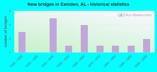
- New bridges - historical statistics
- 31920-1929
- 51940-1949
- 11950-1959
- 41960-1969
- 11970-1979
- 11980-1989
- 11990-1999
- 22000-2009
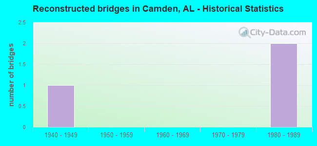
- Reconstructed bridges - Historical Statistics
- 11940-1949
- 01950-1959
- 01960-1969
- 01970-1979
- 21980-1989
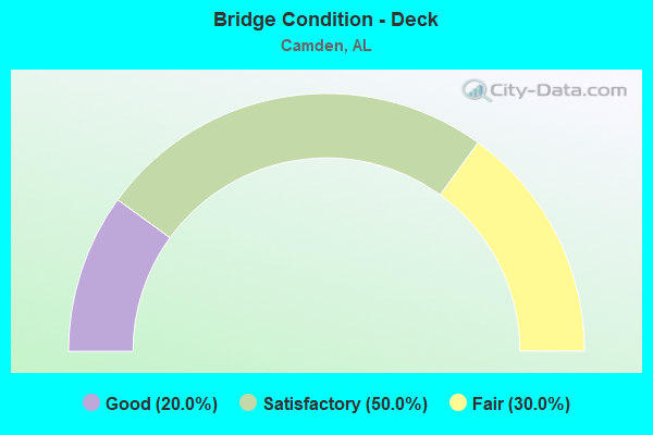
- Bridge Condition - Deck
- 20.0%Good
- 50.0%Satisfactory
- 30.0%Fair
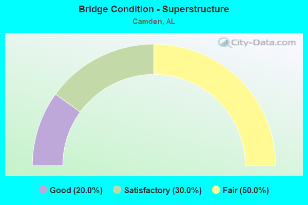
- Bridge Condition - Superstructure
- 20.0%Good
- 30.0%Satisfactory
- 50.0%Fair
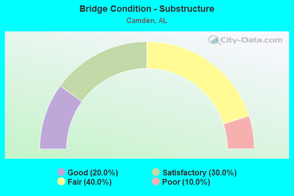
- Bridge Condition - Substructure
- 20.0%Good
- 30.0%Satisfactory
- 40.0%Fair
- 10.0%Poor
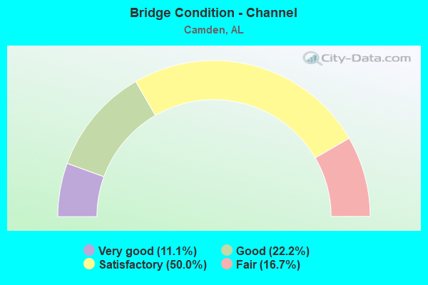
- Bridge Condition - Channel
- 11.1%Very good
- 22.2%Good
- 50.0%Satisfactory
- 16.7%Fair
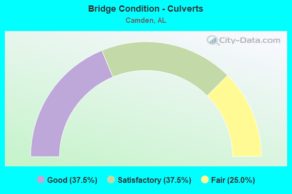
- Bridge Condition - Culverts
- 37.5%Good
- 37.5%Satisfactory
- 25.0%Fair
Find on map >> Show street view
Structure Number: 282, Location: PRATT HWY * MORGAN STR (Lat: 33.545708, Lng: -86.899642), Route carried "on" structure: City street , Year Built: 1925, Status: Posted for load, Structure Length: 2.81m (9.22ft), Average Daily Traffic: 2,500 (year 2016), Truck Traffic: 2%, Average Future Daily Traffic: 2,500 (year 2036), Features Intersected: BRANCH, Facility Carried by Structure: PRATT HWY
Minimum Vertical Clearance: 30+ m (98+ ft), Kilometerpoint: 0.200, Lanes on structure: 2, Owner: City or Municipal Highway Agency, Approaching Roadway Width: 7.0m (23.0ft), Material/Design: Concrete continuous, Design/Construction: Slab, Number Of Spans In Main Unit: 5, Length of Maximum Span: 4.6m (15.1ft), Curb-To-Curb Width: 6.6m (21.7ft), Out-to-Out Width: 7.7m (25.3ft)
Condition: Deck: Fair, Superstructure: Fair, Substructure: Fair, Channel: Fair, Operating Rating: 27.2 metric tons, Method Used To Determine Operating Rating: Field evaluation and documented engineering judgment, Inventory Rating: 20.4 metric tons, Method Used To Determine Inventory Rating: Field evaluation and documented engineering judgment, Structural Evaluation: Somewhat better than minimum adequacy, Deck Geometry: High priority of replacement, Waterway Adequacy: Meets minimum limits, Approach Roadway Alignment: Somewhat better than minimum adequacy, Bridge Posting: Required (Relationship of Operating Rating to Maximum Legal Load: 20.0 - 29.9% below), Length Of Structure Improvement: 3.73m (12.24ft), Designated Inspection Frequency: Every 24 months, Other Special Inspection Frequency: Every 12 months, Inspection Date: July 2020, Other Special Inspection Date: July 2021, Bridge Improvement Cost: $640,000, Roadway Improvement Cost: $64,000, Total Project Cost: $704,000 ( Estimate for 2022), Deck Structure Type: Concrete Cast-file-Place, Wearing Surface/Protective System: Wearing Surface: Bituminous
Find on map >> Show street view
Structure Number: 405, Location: CAMDEN (Lat: 31.993939, Lng: -87.282369), Route carried "on" structure: State highway 28, Year Built: 1927, Status: Open, Structure Length: 0.91m (2.99ft), Average Daily Traffic: 4,910 (year 2013), Truck Traffic: 8%, Average Future Daily Traffic: 6,613 (year 2033), Design Load: H 15, Features Intersected: LITTLE WOLF CREEK
Minimum Vertical Clearance: 7.56m (24.80ft), Kilometerpoint: 135.982, Lanes on structure: 2, Base Highway Network: Yes, Owner: State Highway Agency, Approaching Roadway Width: 10.7m (35.1ft), Material/Design: Concrete, Design/Construction: Culvert, Number Of Spans In Main Unit: 2, Length of Maximum Span: 3.0m (9.8ft)
Condition: Channel: Satisfactory, Culverts: Fair, Operating Rating: 78.8 metric tons, Method Used To Determine Operating Rating: Load Factor (LF), Inventory Rating: 47.4 metric tons, Method Used To Determine Inventory Rating: Load Factor (LF), Structural Evaluation: Somewhat better than minimum adequacy, Waterway Adequacy: Superior to present desirable criteria, Approach Roadway Alignment: Superior to present desirable criteria, Length Of Structure Improvement: 1.58m (5.18ft), Designated Inspection Frequency: Every 24 months, Inspection Date: March 2021, Bridge Improvement Cost: $411,000, Roadway Improvement Cost: $41,000, Total Project Cost: $452,000 ( Estimate for 2022)
Find on map >> Show street view
Structure Number: 2821, Location: POGO (Lat: 34.582169, Lng: -88.133411), Route carried "on" structure: County highway 11, Year Built: 1945, Status: Open, Structure Length: 0.70m (2.30ft), Average Daily Traffic: 400 (year 2006), Truck Traffic: 10%, Average Future Daily Traffic: 500 (year 2039), Design Load: H 15, Features Intersected: CROSSWAY BRANCH, Facility Carried by Structure: POGO RD
Minimum Vertical Clearance: 30+ m (98+ ft), Kilometerpoint: 0.000, Lanes on structure: 2, Owner: County Highway Agency, Approaching Roadway Width: 5.8m (19.0ft), Material/Design: Steel, Design/Construction: Culvert, Number Of Spans In Main Unit: 3, Length of Maximum Span: 1.8m (5.9ft)
Condition: Channel: Satisfactory, Culverts: Fair, Operating Rating: 88.9 metric tons, Method Used To Determine Operating Rating: Load Factor (LF), Inventory Rating: 87.9 metric tons, Method Used To Determine Inventory Rating: Load Factor (LF), Structural Evaluation: Somewhat better than minimum adequacy, Waterway Adequacy: Equal to present minimum criteria, Approach Roadway Alignment: Equal to present minimum criteria, Length Of Structure Improvement: 1.34m (4.40ft), Designated Inspection Frequency: Every 24 months, Inspection Date: March 2021, Bridge Improvement Cost: $309,000, Roadway Improvement Cost: $31,000, Total Project Cost: $340,000 ( Estimate for 2022), Wearing Surface/Protective System: Wearing Surface: Bituminous
Find on map >> Show street view
Structure Number: 2884, Location: 4.3 MI. S. OF LIVINGSTON (Lat: 32.542286, Lng: -88.239297), Route carried "on" structure: US 11, Year Built: 1925, Year Reconstructed: 1946, Status: Open, Structure Length: 1.06m (3.48ft), Average Daily Traffic: 3,420 (year 2013), Truck Traffic: 9%, Average Future Daily Traffic: 4,570 (year 2039), Design Load: H 20, Features Intersected: PARKER CREEK
Minimum Vertical Clearance: 30+ m (98+ ft), Kilometerpoint: 21.168, Lanes on structure: 2, Owner: State Highway Agency, Approaching Roadway Width: 12.8m (42.0ft), Material/Design: Concrete, Design/Construction: Tee Beam, Number Of Spans In Main Unit: 1, Length of Maximum Span: 10.6m (34.8ft), Curb-To-Curb Width: 8.2m (26.9ft), Out-to-Out Width: 9.1m (29.9ft)
Condition: Deck: Satisfactory, Superstructure: Satisfactory, Substructure: Fair, Channel: Satisfactory, Operating Rating: 56.6 metric tons, Method Used To Determine Operating Rating: Load Factor (LF), Inventory Rating: 33.9 metric tons, Method Used To Determine Inventory Rating: Load Factor (LF), Structural Evaluation: Somewhat better than minimum adequacy, Deck Geometry: High priority of corrective action, Waterway Adequacy: Equal to present minimum criteria, Approach Roadway Alignment: Equal to present desirable criteria, Length Of Structure Improvement: 1.74m (5.71ft), Designated Inspection Frequency: Every 24 months, Inspection Date: March 2021, Bridge Improvement Cost: $345,000, Roadway Improvement Cost: $35,000, Total Project Cost: $380,000 ( Estimate for 2022), Deck Structure Type: Concrete Cast-file-Place, Wearing Surface/Protective System: Wearing Surface: Bituminous
Find on map >> Show street view
Structure Number: 2894, Location: 3 MI W OF BLACK (Lat: 31.031167, Lng: -85.794406), Route carried "on" structure: County highway , Year Built: 1946, Year Reconstructed: 1991, Status: Posted for load, Structure Length: 0.91m (2.99ft), Average Daily Traffic: 53 (year 2020), Average Future Daily Traffic: 88 (year 2040), Design Load: H 15, Features Intersected: WHEELER MILL BRANCH, Facility Carried by Structure: OLD MILL ROAD
Minimum Vertical Clearance: 30+ m (98+ ft), Kilometerpoint: 0.010, Lanes on structure: 1, Owner: County Highway Agency, Approaching Roadway Width: 6.1m (20.0ft), Material/Design: Wood or Timber, Design/Construction: Stringer/Multi-beam, Number Of Spans In Main Unit: 2, Length of Maximum Span: 4.6m (15.1ft), Curb-To-Curb Width: 4.6m (15.1ft), Out-to-Out Width: 5.0m (16.4ft)
Condition: Deck: Satisfactory, Superstructure: Satisfactory, Substructure: Fair, Channel: Fair, Operating Rating: 27.4 metric tons, Method Used To Determine Operating Rating: Allowable Stress (AS), Inventory Rating: 20.2 metric tons, Method Used To Determine Inventory Rating: Allowable Stress (AS), Structural Evaluation: Somewhat better than minimum adequacy, Deck Geometry: Better than present minimum criteria, Waterway Adequacy: Meets minimum limits, Approach Roadway Alignment: Better than present minimum criteria, Bridge Posting: Required (Relationship of Operating Rating to Maximum Legal Load: 30.0 - 39.9% below), Length Of Structure Improvement: 1.58m (5.18ft), Designated Inspection Frequency: Every 24 months, Other Special Inspection Frequency: Every 12 months, Inspection Date: July 2020, Other Special Inspection Date: July 2021, Bridge Improvement Cost: $173,000, Roadway Improvement Cost: $17,000, Total Project Cost: $190,000 ( Estimate for 2022), Deck Structure Type: Wood or Timber, Wearing Surface/Protective System: Wearing Surface: Wood or Timber
Find on map >> Show street view
Structure Number: 2906, Location: CUBA (Lat: 32.433200, Lng: -88.375733), Route carried "on" structure: US 11, Year Built: 1946, Status: Open, Structure Length: 2.93m (9.61ft), Average Daily Traffic: 3,200 (year 2013), Truck Traffic: 17%, Average Future Daily Traffic: 4,276 (year 2039), Design Load: H 20, Features Intersected: Trib. of Alamuchee Creek
Minimum Vertical Clearance: 30+ m (98+ ft), Kilometerpoint: 3.215, Lanes on structure: 2, Owner: State Highway Agency, Approaching Roadway Width: 12.8m (42.0ft), Material/Design: Concrete, Design/Construction: Tee Beam, Number Of Spans In Main Unit: 4, Length of Maximum Span: 7.3m (24.0ft), Curb-To-Curb Width: 7.9m (25.9ft), Out-to-Out Width: 8.8m (28.9ft)
Condition: Deck: Satisfactory, Superstructure: Fair, Substructure: Satisfactory, Channel: Satisfactory, Operating Rating: 39.0 metric tons, Method Used To Determine Operating Rating: Load Factor (LF), Inventory Rating: 23.4 metric tons, Method Used To Determine Inventory Rating: Load Factor (LF), Structural Evaluation: Somewhat better than minimum adequacy, Deck Geometry: High priority of corrective action, Waterway Adequacy: Better than present minimum criteria, Approach Roadway Alignment: Equal to present minimum criteria, Length Of Structure Improvement: 3.84m (12.60ft), Designated Inspection Frequency: Every 24 months, Inspection Date: March 2021, Bridge Improvement Cost: $737,000, Roadway Improvement Cost: $74,000, Total Project Cost: $811,000 ( Estimate for 2022), Deck Structure Type: Concrete Cast-file-Place, Wearing Surface/Protective System: Wearing Surface: Bituminous
Find on map >> Show street view
Structure Number: 2907, Location: 1.5 MI. N. OF CUBA (Lat: 32.447639, Lng: -88.356936), Route carried "on" structure: US 11, Year Built: 1946, Status: Open, Structure Length: 0.77m (2.53ft), Average Daily Traffic: 2,710 (year 2013), Truck Traffic: 7%, Average Future Daily Traffic: 3,621 (year 2041), Design Load: H 15, Features Intersected: UT ALAMUCHEE CREEK
Minimum Vertical Clearance: 30+ m (98+ ft), Kilometerpoint: 5.580, Lanes on structure: 2, Owner: State Highway Agency, Approaching Roadway Width: 12.2m (40.0ft), Skew: 3 degrees, Material/Design: Concrete, Design/Construction: Culvert, Number Of Spans In Main Unit: 2, Length of Maximum Span: 3.0m (9.8ft)
Condition: Channel: Satisfactory, Culverts: Satisfactory, Operating Rating: 88.9 metric tons, Method Used To Determine Operating Rating: Load Factor (LF), Inventory Rating: 67.6 metric tons, Method Used To Determine Inventory Rating: Load Factor (LF), Structural Evaluation: Equal to present minimum criteria, Waterway Adequacy: Better than present minimum criteria, Approach Roadway Alignment: Equal to present desirable criteria, Length Of Structure Improvement: 1.42m (4.66ft), Designated Inspection Frequency: Every 24 months, Inspection Date: March 2021, Bridge Improvement Cost: $493,000, Roadway Improvement Cost: $49,000, Total Project Cost: $542,000 ( Estimate for 2022)
Find on map >> Show street view
Structure Number: 2908, Location: 1.5 MI. S. OF YORK (Lat: 32.477272, Lng: -88.321533), Route carried "on" structure: US 11, Year Built: 1946, Status: Open, Structure Length: 2.19m (7.19ft), Average Daily Traffic: 2,070 (year 2020), Truck Traffic: 4%, Average Future Daily Traffic: 3,392 (year 2040), Design Load: H 20, Features Intersected: UT TOOMSUBA CREEK
Minimum Vertical Clearance: 30+ m (98+ ft), Kilometerpoint: 10.297, Lanes on structure: 2, Owner: State Highway Agency, Approaching Roadway Width: 12.2m (40.0ft), Material/Design: Concrete, Design/Construction: Tee Beam, Number Of Spans In Main Unit: 3, Length of Maximum Span: 7.3m (24.0ft), Curb-To-Curb Width: 7.9m (25.9ft), Out-to-Out Width: 8.8m (28.9ft)
Condition: Deck: Fair, Superstructure: Fair, Substructure: Satisfactory, Channel: Good, Operating Rating: 39.0 metric tons, Method Used To Determine Operating Rating: Load Factor (LF), Inventory Rating: 23.4 metric tons, Method Used To Determine Inventory Rating: Load Factor (LF), Structural Evaluation: Somewhat better than minimum adequacy, Deck Geometry: High priority of corrective action, Waterway Adequacy: Better than present minimum criteria, Approach Roadway Alignment: Equal to present minimum criteria, Length Of Structure Improvement: 2.99m (9.81ft), Designated Inspection Frequency: Every 24 months, Inspection Date: Febuary 2021, Bridge Improvement Cost: $574,000, Roadway Improvement Cost: $57,000, Total Project Cost: $631,000 ( Estimate for 2022), Deck Structure Type: Concrete Cast-file-Place
Find on map >> Show street view
Structure Number: 4479, Location: CAMDEN (Lat: 31.983789, Lng: -87.285547), Route carried "on" structure: State highway 265, Year Built: 1952, Status: Open, Structure Length: 0.85m (2.79ft), Average Daily Traffic: 500 (year 2013), Truck Traffic: 20%, Average Future Daily Traffic: 610 (year 2033), Design Load: H 15, Features Intersected: TOWN BRANCH
Minimum Vertical Clearance: 30+ m (98+ ft), Kilometerpoint: 32.666, Lanes on structure: 2, Owner: State Highway Agency, Approaching Roadway Width: 8.8m (28.9ft), Material/Design: Concrete, Design/Construction: Culvert, Number Of Spans In Main Unit: 2, Length of Maximum Span: 3.0m (9.8ft)
Condition: Channel: Good, Culverts: Good, Operating Rating: 87.9 metric tons, Method Used To Determine Operating Rating: Load Factor (LF), Inventory Rating: 52.7 metric tons, Method Used To Determine Inventory Rating: Load Factor (LF), Structural Evaluation: Better than present minimum criteria, Waterway Adequacy: Better than present minimum criteria, Approach Roadway Alignment: Better than present minimum criteria, Length Of Structure Improvement: 1.51m (4.95ft), Designated Inspection Frequency: Every 24 months, Inspection Date: November 2021, Bridge Improvement Cost: $315,000, Roadway Improvement Cost: $32,000, Total Project Cost: $347,000 ( Estimate for 2022)
Find on map >> Show street view
Structure Number: 7163, Location: 2 MI. N. OF INT. OFS.R.10 (Lat: 32.019094, Lng: -87.338278), Route carried "on" structure: State highway 221, Year Built: 1960, Status: Open, Structure Length: 0.98m (3.22ft), Average Daily Traffic: 1,260 (year 2013), Truck Traffic: 22%, Average Future Daily Traffic: 1,431 (year 2033), Design Load: H 15, Features Intersected: ROCK WEST CREEK
Minimum Vertical Clearance: 30+ m (98+ ft), Kilometerpoint: 6.460, Lanes on structure: 2, Owner: State Highway Agency, Approaching Roadway Width: 9.4m (30.8ft), Material/Design: Concrete, Design/Construction: Culvert, Number Of Spans In Main Unit: 3, Length of Maximum Span: 3.0m (9.8ft)
Condition: Channel: Satisfactory, Culverts: Satisfactory, Operating Rating: 63.2 metric tons, Method Used To Determine Operating Rating: Load Factor (LF), Inventory Rating: 37.9 metric tons, Method Used To Determine Inventory Rating: Load Factor (LF), Structural Evaluation: Equal to present minimum criteria, Waterway Adequacy: Better than present minimum criteria, Approach Roadway Alignment: Equal to present desirable criteria, Length Of Structure Improvement: 1.65m (5.41ft), Designated Inspection Frequency: Every 24 months, Inspection Date: December 2021, Bridge Improvement Cost: $306,000, Roadway Improvement Cost: $31,000, Total Project Cost: $337,000 ( Estimate for 2022)
Find on map >> Show street view
Structure Number: 8644, Location: 0.10 MI E OF ALA 221 (Lat: 32.027289, Lng: -87.337569), Route carried "on" structure: County highway 14, Year Built: 1965, Status: Posted for load, Structure Length: 0.61m (2.00ft), Average Daily Traffic: 35 (year 2016), Average Future Daily Traffic: 45 (year 2036), Features Intersected: UNNAMED BRANCH
Minimum Vertical Clearance: 30+ m (98+ ft), Kilometerpoint: 0.010, Lanes on structure: 1, Owner: County Highway Agency, Approaching Roadway Width: 3.5m (11.5ft), Skew: 1 degrees, Material/Design: Wood or Timber, Design/Construction: Stringer/Multi-beam, Number Of Spans In Main Unit: 1, Length of Maximum Span: 5.9m (19.4ft), Curb-To-Curb Width: 6.0m (19.7ft), Out-to-Out Width: 6.6m (21.7ft)
Condition: Deck: Satisfactory, Superstructure: Fair, Substructure: Poor, Channel: Satisfactory, Operating Rating: 5.4 metric tons, Method Used To Determine Operating Rating: Allowable Stress (AS), Inventory Rating: 3.6 metric tons, Method Used To Determine Inventory Rating: Allowable Stress (AS), Structural Evaluation: High priority of replacement, Deck Geometry: Meets minimum limits, Waterway Adequacy: Equal to present minimum criteria, Approach Roadway Alignment: Better than present minimum criteria, Bridge Posting: Required (Relationship of Operating Rating to Maximum Legal Load: > 39.9% below), Length Of Structure Improvement: 1.22m (4.00ft), Designated Inspection Frequency: Every 24 months, Other Special Inspection Frequency: Every 12 months, Inspection Date: July 2021, Other Special Inspection Date: July 2021, Bridge Improvement Cost: $176,000, Roadway Improvement Cost: $18,000, Total Project Cost: $194,000 ( Estimate for 2022), Deck Structure Type: Concrete Cast-file-Place, Wearing Surface/Protective System: Wearing Surface: Bituminous
Find on map >> Show street view
Structure Number: 9327, Location: CAMDEN BY-PASS (Lat: 31.998236, Lng: -87.279933), Route carried "on" structure: State highway 10, Year Built: 1967, Status: Open, Structure Length: 0.75m (2.46ft), Average Daily Traffic: 5,580 (year 2013), Truck Traffic: 14%, Average Future Daily Traffic: 7,268 (year 2033), Design Load: H 20, Features Intersected: BRANCH
Minimum Vertical Clearance: 30+ m (98+ ft), Kilometerpoint: 127.119, Lanes on structure: 2, Owner: State Highway Agency, Approaching Roadway Width: 13.4m (44.0ft), Skew: 4 degrees, Material/Design: Concrete, Design/Construction: Culvert, Number Of Spans In Main Unit: 2, Length of Maximum Span: 2.4m (7.9ft), Out-to-Out Width: 36.6m (120.1ft)
Condition: Channel: Satisfactory, Culverts: Satisfactory, Operating Rating: 88.9 metric tons, Method Used To Determine Operating Rating: Load Factor (LF), Inventory Rating: 88.9 metric tons, Method Used To Determine Inventory Rating: Load Factor (LF), Structural Evaluation: Equal to present minimum criteria, Waterway Adequacy: Better than present minimum criteria, Approach Roadway Alignment: Equal to present desirable criteria, Length Of Structure Improvement: 1.40m (4.59ft), Designated Inspection Frequency: Every 24 months, Inspection Date: May 2021, Bridge Improvement Cost: $968,000, Roadway Improvement Cost: $97,000, Total Project Cost: $1,065,000 ( Estimate for 2022)
Find on map >> Show street view
Structure Number: 9988, Location: 3.7 MI. W. OF CAMDEN (Lat: 31.985311, Lng: -87.359300), Route carried "on" structure: State highway 10, Year Built: 1969, Status: Open, Structure Length: 0.66m (2.17ft), Average Daily Traffic: 3,530 (year 2013), Truck Traffic: 16%, Average Future Daily Traffic: 4,598 (year 2033), Design Load: HS 20, Features Intersected: BRANCH
Minimum Vertical Clearance: 30+ m (98+ ft), Kilometerpoint: 118.528, Lanes on structure: 2, Owner: State Highway Agency, Approaching Roadway Width: 13.4m (44.0ft), Material/Design: Concrete, Design/Construction: Culvert, Number Of Spans In Main Unit: 2, Length of Maximum Span: 3.0m (9.8ft), Out-to-Out Width: 18.0m (59.1ft)
Condition: Channel: Good, Culverts: Good, Operating Rating: 88.9 metric tons, Method Used To Determine Operating Rating: Load Factor (LF), Inventory Rating: 82.8 metric tons, Method Used To Determine Inventory Rating: Load Factor (LF), Structural Evaluation: Better than present minimum criteria, Waterway Adequacy: Somewhat better than minimum adequacy, Approach Roadway Alignment: Equal to present desirable criteria, Length Of Structure Improvement: 1.29m (4.23ft), Designated Inspection Frequency: Every 24 months, Inspection Date: May 2021, Bridge Improvement Cost: $439,000, Roadway Improvement Cost: $44,000, Total Project Cost: $483,000 ( Estimate for 2022)
Find on map >> Show street view
Structure Number: 14897, Location: 5 MI. S. OF CAMDEN (Lat: 31.955000, Lng: -87.338333), Route carried "on" structure: State highway 41, Year Built: 1989, Status: Open, Structure Length: 5.94m (19.49ft), Average Daily Traffic: 1,610 (year 2013), Truck Traffic: 15%, Average Future Daily Traffic: 1,996 (year 2033), Design Load: HS 20, Features Intersected: PURSLEY CREEK
Minimum Vertical Clearance: 30+ m (98+ ft), Kilometerpoint: 134.692, Lanes on structure: 2, Owner: State Highway Agency, Approaching Roadway Width: 12.2m (40.0ft), Material/Design: Prestressed concrete, Design/Construction: Stringer/Multi-beam, Number Of Spans In Main Unit: 3, Length of Maximum Span: 19.8m (65.0ft), Curb-To-Curb Width: 12.2m (40.0ft), Out-to-Out Width: 12.6m (41.3ft)
Condition: Deck: Good, Superstructure: Good, Substructure: Good, Channel: Good, Operating Rating: 77.6 metric tons, Method Used To Determine Operating Rating: Load Factor (LF), Inventory Rating: 46.4 metric tons, Method Used To Determine Inventory Rating: Load Factor (LF), Structural Evaluation: Better than present minimum criteria, Deck Geometry: Better than present minimum criteria, Waterway Adequacy: Equal to present desirable criteria, Approach Roadway Alignment: Equal to present desirable criteria, Length Of Structure Improvement: 6.98m (22.90ft), Designated Inspection Frequency: Every 24 months, Inspection Date: April 2020, Bridge Improvement Cost: $1,962,000, Roadway Improvement Cost: $196,000, Total Project Cost: $2,158,000 ( Estimate for 2022), Deck Structure Type: Concrete Cast-file-Place
Find on map >> Show street view
Structure Number: 16081, Location: 1 M S CO RD 1162 (Lat: 34.275586, Lng: -86.311211), Route carried "on" structure: County highway 296, Year Built: 1970, Year Reconstructed: 1994, Status: Posted for load, Structure Length: 0.98m (3.22ft), Average Daily Traffic: 200 (year 2000), Truck Traffic: 1%, Average Future Daily Traffic: 280 (year 2040), Design Load: H 10, Features Intersected: CO RD 1162;CO RD 1293
Minimum Vertical Clearance: 30+ m (98+ ft), Kilometerpoint: 0.999, Lanes on structure: 2, Owner: County Highway Agency, Approaching Roadway Width: 6.1m (20.0ft), Skew: 1 degrees, Material/Design: Steel, Design/Construction: Stringer/Multi-beam, Number Of Spans In Main Unit: 1, Length of Maximum Span: 9.1m (29.9ft), Curb-To-Curb Width: 5.6m (18.4ft), Out-to-Out Width: 5.9m (19.4ft)
Condition: Deck: Fair, Superstructure: Fair, Substructure: Satisfactory, Channel: Very good, Operating Rating: 19.8 metric tons, Method Used To Determine Operating Rating: Load Factor (LF), Inventory Rating: 11.8 metric tons, Method Used To Determine Inventory Rating: Load Factor (LF), Structural Evaluation: Meets minimum limits, Waterway Adequacy: Meets minimum limits, Approach Roadway Alignment: Equal to present desirable criteria, Bridge Posting: Required (Relationship of Operating Rating to Maximum Legal Load: > 39.9% below), Length Of Structure Improvement: 1.65m (5.41ft), Designated Inspection Frequency: Every 24 months, Other Special Inspection Frequency: Every 12 months, Inspection Date: June 2020, Other Special Inspection Date: June 2021, Bridge Improvement Cost: $215,000, Roadway Improvement Cost: $22,000, Total Project Cost: $237,000 ( Estimate for 2022), Deck Structure Type: Other, Wearing Surface/Protective System: Wearing Surface: Other, Membrane: Other, Deck Protection: Other
Find on map >> Show street view
Structure Number: 16102, Location: 0.4 MILES N. ON CO RD 19 (Lat: 31.991722, Lng: -87.371417), Route carried "on" structure: County highway 19, Year Built: 1993, Status: Open, Structure Length: 5.18m (16.99ft), Average Daily Traffic: 400 (year 2016), Truck Traffic: 5%, Average Future Daily Traffic: 600 (year 2036), Design Load: HS 20, Features Intersected: ROCKWEST CREEK
Minimum Vertical Clearance: 30+ m (98+ ft), Kilometerpoint: 0.010, Lanes on structure: 2, Owner: County Highway Agency, Approaching Roadway Width: 6.7m (22.0ft), Material/Design: Concrete, Design/Construction: Channel Beam, Number Of Spans In Main Unit: 5, Length of Maximum Span: 10.4m (34.1ft), Curb-To-Curb Width: 8.6m (28.2ft), Out-to-Out Width: 9.4m (30.8ft)
Condition: Deck: Satisfactory, Superstructure: Satisfactory, Substructure: Fair, Channel: Fair, Operating Rating: 71.2 metric tons, Method Used To Determine Operating Rating: Load Factor (LF), Inventory Rating: 42.7 metric tons, Method Used To Determine Inventory Rating: Load Factor (LF), Structural Evaluation: Somewhat better than minimum adequacy, Deck Geometry: Equal to present minimum criteria, Waterway Adequacy: Equal to present minimum criteria, Approach Roadway Alignment: Better than present minimum criteria, Length Of Structure Improvement: 6.21m (20.37ft), Designated Inspection Frequency: Every 24 months, Inspection Date: September 2020, Bridge Improvement Cost: $1,277,000, Roadway Improvement Cost: $128,000, Total Project Cost: $1,405,000 ( Estimate for 2022), Deck Structure Type: Concrete Precast Panels
Find on map >> Show street view
Structure Number: 17909, Location: CAMDEN (Lat: 31.979481, Lng: -87.281631), Route carried "on" structure: State highway 265, Year Built: 2002, Status: Open, Structure Length: 7.77m (25.49ft), Average Daily Traffic: 500 (year 2013), Truck Traffic: 20%, Average Future Daily Traffic: 610 (year 2033), Design Load: HS 20, Features Intersected: PURSLEY CREEK
Minimum Vertical Clearance: 30+ m (98+ ft), Kilometerpoint: 32.015, Lanes on structure: 2, Owner: State Highway Agency, Approaching Roadway Width: 12.2m (40.0ft), Material/Design: Prestressed concrete continuous, Design/Construction: Stringer/Multi-beam, Number Of Spans In Main Unit: 3, Length of Maximum Span: 25.9m (85.0ft), Curb-To-Curb Width: 12.2m (40.0ft), Out-to-Out Width: 13.0m (42.7ft)
Condition: Deck: Good, Superstructure: Good, Substructure: Good, Channel: Very good, Operating Rating: 62.4 metric tons, Method Used To Determine Operating Rating: Load Factor (LF), Inventory Rating: 36.7 metric tons, Method Used To Determine Inventory Rating: Load Factor (LF), Structural Evaluation: Better than present minimum criteria, Deck Geometry: Equal to present desirable criteria, Waterway Adequacy: Equal to present desirable criteria, Approach Roadway Alignment: Equal to present desirable criteria, Length Of Structure Improvement: 8.79m (28.84ft), Designated Inspection Frequency: Every 24 months, Inspection Date: November 2021, Bridge Improvement Cost: $2,531,000, Roadway Improvement Cost: $253,000, Total Project Cost: $2,784,000 ( Estimate for 2022), Deck Structure Type: Concrete Cast-file-Place
Find on map >> Show street view
Structure Number: 18433, Location: INT. OF CO. RD.95 AND 52 (Lat: 33.290211, Lng: -86.835925), Route carried "on" structure: County highway 95, Year Built: 2001, Status: Open, Structure Length: 0.85m (2.79ft), Average Daily Traffic: 10,766 (year 2021), Truck Traffic: 5%, Average Future Daily Traffic: 15,074 (year 2041), Design Load: HS 20, Features Intersected: LEE BROOK
Minimum Vertical Clearance: 30+ m (98+ ft), Kilometerpoint: 0.000, Lanes on structure: 3, Owner: County Highway Agency, Approaching Roadway Width: 7.3m (24.0ft), Material/Design: Concrete, Design/Construction: Culvert, Number Of Spans In Main Unit: 2, Length of Maximum Span: 4.3m (14.1ft), Curb-To-Curb Width: 12.5m (41.0ft), Out-to-Out Width: 13.4m (44.0ft)
Condition: Channel: Satisfactory, Culverts: Good, Operating Rating: 85.2 metric tons, Method Used To Determine Operating Rating: Load Factor (LF), Inventory Rating: 51.1 metric tons, Method Used To Determine Inventory Rating: Load Factor (LF), Structural Evaluation: Better than present minimum criteria, Deck Geometry: Meets minimum limits, Waterway Adequacy: Equal to present minimum criteria, Approach Roadway Alignment: Equal to present desirable criteria, Length Of Structure Improvement: 1.52m (4.99ft), Designated Inspection Frequency: Every 24 months, Inspection Date: March 2021, Bridge Improvement Cost: $403,000, Roadway Improvement Cost: $40,000, Total Project Cost: $443,000 ( Estimate for 2022)