Bridge Statistics for Cameron, South Carolina (SC)
Condition, Traffic, Stress, Structural Evaluation, Project Costs
- National Bridge Inventory (NBI) Statistics
- 13Number of bridges
- 75ft / 23.2mTotal length
- $348,000Total costs
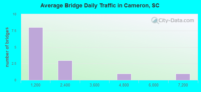
- 18,525Total average daily traffic
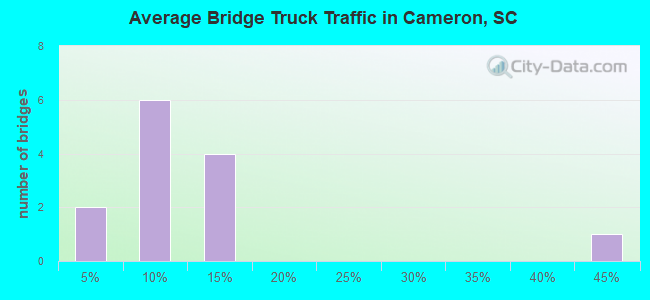
- 2,875Total average daily truck traffic
- 27,822Total future (year 2040) average daily traffic
- National Bridge Inventory (NBI) Registered Bridges for Cameron
- No street view available for this location
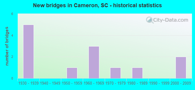
- New bridges - historical statistics
- 51930-1939
- 11950-1959
- 31960-1969
- 11970-1979
- 11980-1989
- 22000-2009
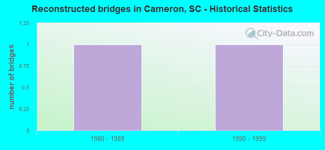
- Reconstructed bridges - Historical Statistics
- 11980-1989
- 11990-1999
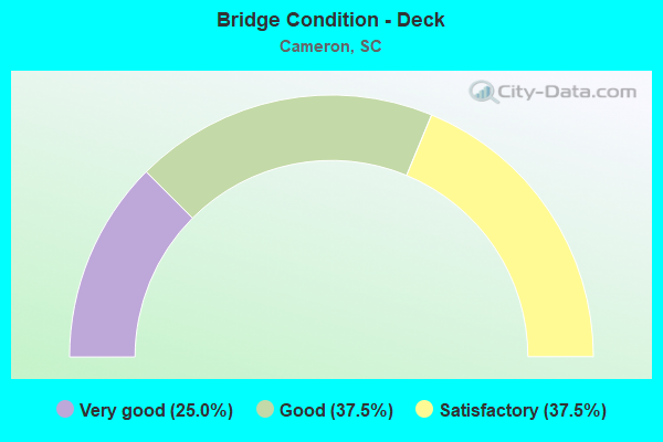
- Bridge Condition - Deck
- 25.0%Very good
- 37.5%Good
- 37.5%Satisfactory
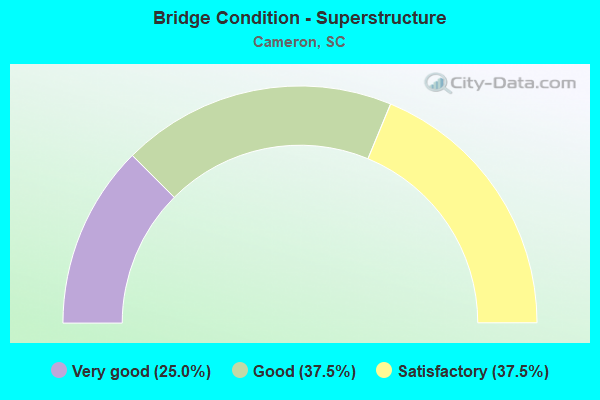
- Bridge Condition - Superstructure
- 25.0%Very good
- 37.5%Good
- 37.5%Satisfactory
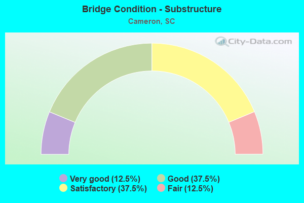
- Bridge Condition - Substructure
- 12.5%Very good
- 37.5%Good
- 37.5%Satisfactory
- 12.5%Fair
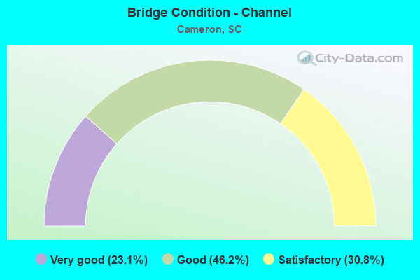
- Bridge Condition - Channel
- 23.1%Very good
- 46.2%Good
- 30.8%Satisfactory
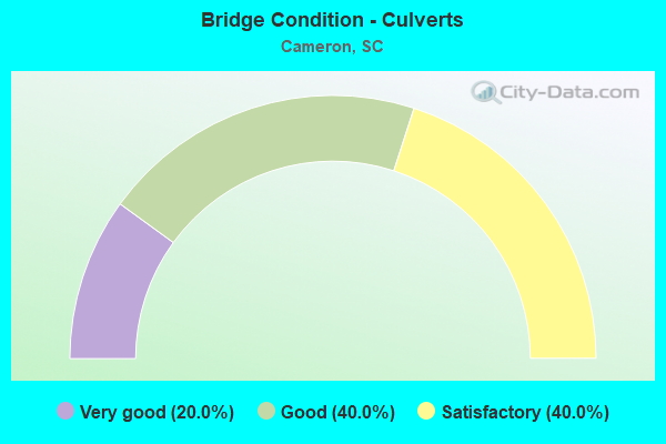
- Bridge Condition - Culverts
- 20.0%Very good
- 40.0%Good
- 40.0%Satisfactory
Find on map >> Show street view
Structure Number: 389, Location: 2 MI S CAMERON (Lat: 33.538272, Lng: -80.700550), Route carried "on" structure: State highway 90, Year Built: 1930, Status: Open, Structure Length: 0.98m (3.22ft), Average Daily Traffic: 125 (year 2020), Truck Traffic: 5%, Average Future Daily Traffic: 160 (year 2040), Design Load: H 15, Features Intersected: FOUR HOLE SWAMP
Minimum Vertical Clearance: 30+ m (98+ ft), Kilometerpoint: 1.038, Lanes on structure: 2, Owner: State Highway Agency, Approaching Roadway Width: 5.8m (19.0ft), Material/Design: Concrete, Design/Construction: Culvert, Number Of Spans In Main Unit: 3, Length of Maximum Span: 3.0m (9.8ft), Curb-To-Curb Width: 8.5m (27.9ft), Out-to-Out Width: 9.1m (29.9ft)
Condition: Channel: Good, Culverts: Very good, Operating Rating: 19.1 metric tons, Method Used To Determine Operating Rating: Load and Resistance Factor Rating (LRFR) rating reported by rating factor(RF) method using HL-93 loadings, Inventory Rating: 14.6 metric tons, Method Used To Determine Inventory Rating: Load and Resistance Factor Rating (LRFR) rating reported by rating factor(RF) method using HL-93 loadings, Structural Evaluation: Meets minimum limits, Deck Geometry: Equal to present minimum criteria, Waterway Adequacy: Better than present minimum criteria, Approach Roadway Alignment: Equal to present desirable criteria, Length Of Structure Improvement: 0.98m (3.22ft), Designated Inspection Frequency: Every 24 months, Inspection Date: July 2021
Find on map >> Show street view
Structure Number: 39, Location: 0.5 MI E CAMERON (Lat: 33.556769, Lng: -80.676736), Route carried "on" structure: State highway 127, Year Built: 1930, Status: Open, Structure Length: 0.64m (2.10ft), Average Daily Traffic: 150 (year 2020), Truck Traffic: 5%, Average Future Daily Traffic: 192 (year 2040), Design Load: H 15, Features Intersected: FLEA BITE CREEK
Minimum Vertical Clearance: 30+ m (98+ ft), Kilometerpoint: 2.921, Lanes on structure: 2, Owner: State Highway Agency, Approaching Roadway Width: 5.6m (18.4ft), Material/Design: Concrete, Design/Construction: Culvert, Number Of Spans In Main Unit: 2, Length of Maximum Span: 3.0m (9.8ft), Curb-To-Curb Width: 8.5m (27.9ft), Out-to-Out Width: 9.1m (29.9ft)
Condition: Channel: Satisfactory, Culverts: Satisfactory, Operating Rating: 35.6 metric tons, Method Used To Determine Operating Rating: Load and Resistance Factor Rating (LRFR) rating reported by rating factor(RF) method using HL-93 loadings, Inventory Rating: 27.5 metric tons, Method Used To Determine Inventory Rating: Load and Resistance Factor Rating (LRFR) rating reported by rating factor(RF) method using HL-93 loadings, Structural Evaluation: Equal to present minimum criteria, Deck Geometry: Equal to present minimum criteria, Waterway Adequacy: Better than present minimum criteria, Approach Roadway Alignment: Equal to present minimum criteria, Length Of Structure Improvement: 0.64m (2.10ft), Designated Inspection Frequency: Every 24 months, Inspection Date: July 2021
Find on map >> Show street view
Structure Number: 497, Location: 9.6 MI NW OF MCBEE (Lat: 34.574550, Lng: -80.364742), Route carried "on" structure: State highway 151, Year Built: 1931, Year Reconstructed: 1997, Status: Open, Structure Length: 0.67m (2.20ft), Average Daily Traffic: 4,700 (year 2020), Truck Traffic: 42%, Average Future Daily Traffic: 8,178 (year 2040), Design Load: H 15, Features Intersected: SANDY RUN BR
Minimum Vertical Clearance: 30+ m (98+ ft), Kilometerpoint: 25.305, Lanes on structure: 2, Base Highway Network: Yes, Owner: State Highway Agency, Approaching Roadway Width: 10.4m (34.1ft), Skew: 3 degrees, Material/Design: Concrete, Design/Construction: Culvert, Number Of Spans In Main Unit: 2, Length of Maximum Span: 3.0m (9.8ft), Curb-To-Curb Width: 10.4m (34.1ft), Out-to-Out Width: 45.7m (149.9ft)
Condition: Channel: Good, Culverts: Good, Operating Rating: 97.2 metric tons, Method Used To Determine Operating Rating: Load and Resistance Factor Rating (LRFR) rating reported by rating factor(RF) method using HL-93 loadings, Inventory Rating: 81.3 metric tons, Method Used To Determine Inventory Rating: Load and Resistance Factor Rating (LRFR) rating reported by rating factor(RF) method using HL-93 loadings, Structural Evaluation: Better than present minimum criteria, Deck Geometry: Somewhat better than minimum adequacy, Waterway Adequacy: Equal to present desirable criteria, Approach Roadway Alignment: Equal to present desirable criteria, Length Of Structure Improvement: 1.29m (4.23ft), Designated Inspection Frequency: Every 24 months, Inspection Date: December 2021, Bridge Improvement Cost: $48,000, Roadway Improvement Cost: $12,000, Total Project Cost: $72,000 ( Estimate for 2021)
Find on map >> Show street view
Structure Number: 893, Location: 8 MI NE ORANGEBURG (Lat: 33.531758, Lng: -80.766847), Route carried "on" structure: State highway 33, Year Built: 1938, Status: Open, Structure Length: 1.16m (3.81ft), Average Daily Traffic: 2,300 (year 2020), Truck Traffic: 12%, Average Future Daily Traffic: 3,358 (year 2040), Design Load: H 15, Features Intersected: BULL SWAMP
Minimum Vertical Clearance: 30+ m (98+ ft), Kilometerpoint: 11.444, Lanes on structure: 2, Owner: State Highway Agency, Approaching Roadway Width: 7.3m (24.0ft), Material/Design: Concrete, Design/Construction: Culvert, Number Of Spans In Main Unit: 3, Length of Maximum Span: 3.7m (12.1ft), Curb-To-Curb Width: 12.8m (42.0ft), Out-to-Out Width: 14.6m (47.9ft)
Condition: Channel: Very good, Culverts: Satisfactory, Operating Rating: 35.3 metric tons, Method Used To Determine Operating Rating: Load and Resistance Factor Rating (LRFR) rating reported by rating factor(RF) method using HL-93 loadings, Inventory Rating: 27.2 metric tons, Method Used To Determine Inventory Rating: Load and Resistance Factor Rating (LRFR) rating reported by rating factor(RF) method using HL-93 loadings, Structural Evaluation: Equal to present minimum criteria, Deck Geometry: Equal to present minimum criteria, Waterway Adequacy: Equal to present minimum criteria, Approach Roadway Alignment: Equal to present desirable criteria, Bridge Posting: Required (Relationship of Operating Rating to Maximum Legal Load: > 39.9% below), Length Of Structure Improvement: 1.82m (5.97ft), Designated Inspection Frequency: Every 24 months, Inspection Date: December 2021, Bridge Improvement Cost: $184,000, Roadway Improvement Cost: $46,000, Total Project Cost: $276,000 ( Estimate for 2021)
Find on map >> Show street view
Structure Number: 927, Location: 0.5MI S OF CAMERON (Lat: 33.551189, Lng: -80.728200), Route carried "on" structure: State highway 33, Year Built: 1939, Status: Open, Structure Length: 0.98m (3.22ft), Average Daily Traffic: 2,100 (year 2020), Truck Traffic: 9%, Average Future Daily Traffic: 3,066 (year 2040), Design Load: H 15, Features Intersected: FOUR HOLE SWAMP
Minimum Vertical Clearance: 30+ m (98+ ft), Kilometerpoint: 0.364, Lanes on structure: 2, Owner: State Highway Agency, Approaching Roadway Width: 7.3m (24.0ft), Material/Design: Concrete, Design/Construction: Culvert, Number Of Spans In Main Unit: 3, Length of Maximum Span: 3.0m (9.8ft), Curb-To-Curb Width: 11.0m (36.1ft), Out-to-Out Width: 11.6m (38.1ft)
Condition: Channel: Good, Culverts: Good, Operating Rating: 24.9 metric tons, Method Used To Determine Operating Rating: Load and Resistance Factor Rating (LRFR) rating reported by rating factor(RF) method using HL-93 loadings, Inventory Rating: 19.4 metric tons, Method Used To Determine Inventory Rating: Load and Resistance Factor Rating (LRFR) rating reported by rating factor(RF) method using HL-93 loadings, Structural Evaluation: Somewhat better than minimum adequacy, Deck Geometry: Somewhat better than minimum adequacy, Waterway Adequacy: Equal to present minimum criteria, Approach Roadway Alignment: Equal to present desirable criteria, Length Of Structure Improvement: 0.98m (3.22ft), Designated Inspection Frequency: Every 24 months, Inspection Date: July 2020
Find on map >> Show street view
Structure Number: 1973, Location: 6 MI E ORANGEBURG (Lat: 33.505744, Lng: -80.734164), Route carried "on" structure: State highway 65, Year Built: 2003, Status: Open, Structure Length: 2.44m (8.01ft), Average Daily Traffic: 150 (year 2020), Truck Traffic: 10%, Average Future Daily Traffic: 192 (year 2040), Design Load: H 20, Features Intersected: BULL SWAMP
Minimum Vertical Clearance: 30+ m (98+ ft), Kilometerpoint: 6.674, Lanes on structure: 2, Owner: State Highway Agency, Approaching Roadway Width: 6.6m (21.7ft), Material/Design: Prestressed concrete, Design/Construction: Slab, Number Of Spans In Main Unit: 2, Length of Maximum Span: 12.2m (40.0ft), Curb-To-Curb Width: 10.5m (34.4ft), Out-to-Out Width: 11.8m (38.7ft)
Condition: Deck: Very good, Superstructure: Very good, Substructure: Good, Channel: Good, Operating Rating: 19.4 metric tons, Method Used To Determine Operating Rating: Load and Resistance Factor Rating (LRFR) rating reported by rating factor(RF) method using HL-93 loadings, Inventory Rating: 13.6 metric tons, Method Used To Determine Inventory Rating: Load and Resistance Factor Rating (LRFR) rating reported by rating factor(RF) method using HL-93 loadings, Structural Evaluation: Meets minimum limits, Deck Geometry: Better than present minimum criteria, Waterway Adequacy: Better than present minimum criteria, Approach Roadway Alignment: Equal to present desirable criteria, Length Of Structure Improvement: 2.44m (8.01ft), Designated Inspection Frequency: Every 24 months, Inspection Date: December 2020, Deck Structure Type: Concrete Precast Panels, Wearing Surface/Protective System: Wearing Surface: Bituminous
Find on map >> Show street view
Structure Number: 1976, Location: 9MI E ORANGEBURG (Lat: 33.492208, Lng: -80.713919), Route carried "on" structure: State highway 260, Year Built: 2003, Status: Open, Structure Length: 3.66m (12.01ft), Average Daily Traffic: 175 (year 2020), Truck Traffic: 5%, Average Future Daily Traffic: 224 (year 2040), Design Load: HS 20, Features Intersected: BULL SWAMP
Minimum Vertical Clearance: 30+ m (98+ ft), Kilometerpoint: 0.351, Lanes on structure: 2, Owner: State Highway Agency, Approaching Roadway Width: 7.3m (24.0ft), Material/Design: Prestressed concrete, Design/Construction: Slab, Number Of Spans In Main Unit: 3, Length of Maximum Span: 12.2m (40.0ft), Curb-To-Curb Width: 10.4m (34.1ft), Out-to-Out Width: 11.7m (38.4ft)
Condition: Deck: Very good, Superstructure: Very good, Substructure: Satisfactory, Channel: Satisfactory, Operating Rating: 19.1 metric tons, Method Used To Determine Operating Rating: Load and Resistance Factor Rating (LRFR) rating reported by rating factor(RF) method using HL-93 loadings, Inventory Rating: 13.3 metric tons, Method Used To Determine Inventory Rating: Load and Resistance Factor Rating (LRFR) rating reported by rating factor(RF) method using HL-93 loadings, Structural Evaluation: Meets minimum limits, Deck Geometry: Better than present minimum criteria, Waterway Adequacy: Better than present minimum criteria, Approach Roadway Alignment: Equal to present desirable criteria, Length Of Structure Improvement: 3.66m (12.01ft), Designated Inspection Frequency: Every 24 months, Underwater Inspection Frequency: Every 60 months, Inspection Date: December 2020, Underwater Inspection Date: July 2021, Deck Structure Type: Concrete Precast Panels, Wearing Surface/Protective System: Wearing Surface: Bituminous
Find on map >> Show street view
Structure Number: 248, Location: 2MI SE OF CAMERON (Lat: 33.534667, Lng: -80.690169), Route carried "on" structure: US 176, Year Built: 1957, Status: Open, Structure Length: 3.05m (10.01ft), Average Daily Traffic: 1,300 (year 2020), Truck Traffic: 9%, Average Future Daily Traffic: 1,898 (year 2040), Design Load: HS 20, Features Intersected: FLEA BITE CREEK
Minimum Vertical Clearance: 30+ m (98+ ft), Kilometerpoint: 51.018, Lanes on structure: 2, Owner: State Highway Agency, Approaching Roadway Width: 7.3m (24.0ft), Material/Design: Concrete, Design/Construction: Tee Beam, Number Of Spans In Main Unit: 1, Number Of Approach Spans: 2, Length of Maximum Span: 12.2m (40.0ft), Curb or Sidewalk Widths: Left: 0.8m (2.6ft), Right: 0.8m (2.6ft), Curb-To-Curb Width: 9.1m (29.9ft), Out-to-Out Width: 11.0m (36.1ft)
Condition: Deck: Good, Superstructure: Good, Substructure: Very good, Channel: Very good, Operating Rating: 46.3 metric tons, Method Used To Determine Operating Rating: Load and Resistance Factor Rating (LRFR) rating reported by rating factor(RF) method using HL-93 loadings, Inventory Rating: 35.3 metric tons, Method Used To Determine Inventory Rating: Load and Resistance Factor Rating (LRFR) rating reported by rating factor(RF) method using HL-93 loadings, Structural Evaluation: Better than present minimum criteria, Deck Geometry: Somewhat better than minimum adequacy, Waterway Adequacy: Better than present minimum criteria, Approach Roadway Alignment: Equal to present desirable criteria, Length Of Structure Improvement: 3.05m (10.01ft), Designated Inspection Frequency: Every 24 months, Inspection Date: July 2020, Deck Structure Type: Concrete Cast-file-Place, Wearing Surface/Protective System: Wearing Surface: Bituminous
Find on map >> Show street view
Structure Number: 3729, Location: 8MI E ORANGEBURG (Lat: 33.492781, Lng: -80.728425), Route carried "on" structure: State highway 154, Year Built: 1961, Status: Posted for load, Structure Length: 2.29m (7.51ft), Average Daily Traffic: 500 (year 2021), Truck Traffic: 3%, Average Future Daily Traffic: 730 (year 2041), Design Load: H 10, Features Intersected: GRAMLING CREEK SWAMP
Minimum Vertical Clearance: 30+ m (98+ ft), Kilometerpoint: 0.681, Lanes on structure: 2, Owner: State Highway Agency, Approaching Roadway Width: 7.0m (23.0ft), Material/Design: Concrete, Design/Construction: Slab, Number Of Spans In Main Unit: 5, Length of Maximum Span: 4.6m (15.1ft), Curb-To-Curb Width: 7.9m (25.9ft), Out-to-Out Width: 8.4m (27.6ft)
Condition: Deck: Satisfactory, Superstructure: Satisfactory, Substructure: Fair, Channel: Very good, Operating Rating: 20.4 metric tons, Method Used To Determine Operating Rating: Load and Resistance Factor Rating (LRFR) rating reported by rating factor(RF) method using HL-93 loadings, Inventory Rating: 15.9 metric tons, Method Used To Determine Inventory Rating: Load and Resistance Factor Rating (LRFR) rating reported by rating factor(RF) method using HL-93 loadings, Structural Evaluation: Meets minimum limits, Deck Geometry: Somewhat better than minimum adequacy, Waterway Adequacy: Better than present minimum criteria, Approach Roadway Alignment: Equal to present minimum criteria, Bridge Posting: Required (Relationship of Operating Rating to Maximum Legal Load: 30.0 - 39.9% below), Length Of Structure Improvement: 2.29m (7.51ft), Designated Inspection Frequency: Every 24 months, Inspection Date: November 2020, Deck Structure Type: Concrete Precast Panels, Wearing Surface/Protective System: Wearing Surface: Bituminous
Find on map >> Show street view
Structure Number: 4971, Location: 5 MI W PAGELAND (Lat: 34.761347, Lng: -80.474336), Route carried "on" structure: State highway 105, Year Built: 1967, Year Reconstructed: 1991, Status: Posted for load, Structure Length: 1.83m (6.00ft), Average Daily Traffic: 250 (year 2021), Truck Traffic: 14%, Average Future Daily Traffic: 320 (year 2041), Design Load: H 10, Features Intersected: HILLS CREEK
Minimum Vertical Clearance: 30+ m (98+ ft), Kilometerpoint: 6.882, Lanes on structure: 2, Owner: State Highway Agency, Approaching Roadway Width: 9.4m (30.8ft), Material/Design: Concrete, Design/Construction: Slab, Number Of Spans In Main Unit: 4, Length of Maximum Span: 4.6m (15.1ft), Curb-To-Curb Width: 8.0m (26.2ft), Out-to-Out Width: 8.4m (27.6ft)
Condition: Deck: Satisfactory, Superstructure: Satisfactory, Substructure: Satisfactory, Channel: Good, Operating Rating: 19.4 metric tons, Method Used To Determine Operating Rating: Load and Resistance Factor Rating (LRFR) rating reported by rating factor(RF) method using HL-93 loadings, Inventory Rating: 14.9 metric tons, Method Used To Determine Inventory Rating: Load and Resistance Factor Rating (LRFR) rating reported by rating factor(RF) method using HL-93 loadings, Structural Evaluation: Meets minimum limits, Deck Geometry: Somewhat better than minimum adequacy, Waterway Adequacy: Equal to present minimum criteria, Approach Roadway Alignment: Equal to present desirable criteria, Bridge Posting: Required (Relationship of Operating Rating to Maximum Legal Load: 30.0 - 39.9% below), Length Of Structure Improvement: 1.83m (6.00ft), Designated Inspection Frequency: Every 24 months, Inspection Date: September 2021, Deck Structure Type: Concrete Precast Panels, Wearing Surface/Protective System: Wearing Surface: Bituminous
Find on map >> Show street view
Structure Number: 4972, Location: 5MI W PAGELAND (Lat: 34.801158, Lng: -80.488381), Route carried "on" structure: State highway 105, Year Built: 1967, Status: Open, Structure Length: 1.83m (6.00ft), Average Daily Traffic: 250 (year 2021), Truck Traffic: 14%, Average Future Daily Traffic: 320 (year 2041), Design Load: H 10, Features Intersected: DEAD PINE CREEK
Minimum Vertical Clearance: 30+ m (98+ ft), Kilometerpoint: 1.754, Lanes on structure: 2, Owner: State Highway Agency, Approaching Roadway Width: 10.4m (34.1ft), Material/Design: Concrete, Design/Construction: Slab, Number Of Spans In Main Unit: 4, Length of Maximum Span: 4.6m (15.1ft), Curb-To-Curb Width: 7.5m (24.6ft), Out-to-Out Width: 8.4m (27.6ft)
Condition: Deck: Good, Superstructure: Good, Substructure: Satisfactory, Channel: Satisfactory, Operating Rating: 19.4 metric tons, Method Used To Determine Operating Rating: Load and Resistance Factor Rating (LRFR) rating reported by rating factor(RF) method using HL-93 loadings, Inventory Rating: 14.9 metric tons, Method Used To Determine Inventory Rating: Load and Resistance Factor Rating (LRFR) rating reported by rating factor(RF) method using HL-93 loadings, Structural Evaluation: Meets minimum limits, Deck Geometry: Somewhat better than minimum adequacy, Waterway Adequacy: Equal to present minimum criteria, Approach Roadway Alignment: Equal to present minimum criteria, Bridge Posting: Required (Relationship of Operating Rating to Maximum Legal Load: 30.0 - 39.9% below), Length Of Structure Improvement: 1.83m (6.00ft), Designated Inspection Frequency: Every 24 months, Inspection Date: October 2021, Deck Structure Type: Concrete Precast Panels, Wearing Surface/Protective System: Wearing Surface: Bituminous
Find on map >> Show street view
Structure Number: 7019, Location: 2MI W CAMERON (Lat: 33.542481, Lng: -80.732969), Route carried "on" structure: State highway 1863, Year Built: 1977, Status: Open, Structure Length: 1.37m (4.49ft), Average Daily Traffic: 125 (year 2020), Truck Traffic: 5%, Average Future Daily Traffic: 160 (year 2040), Design Load: H 15, Features Intersected: BAY BRANCH
Minimum Vertical Clearance: 30+ m (98+ ft), Kilometerpoint: 0.201, Lanes on structure: 2, Owner: State Highway Agency, Approaching Roadway Width: 4.4m (14.4ft), Material/Design: Concrete, Design/Construction: Slab, Number Of Spans In Main Unit: 3, Length of Maximum Span: 4.6m (15.1ft), Curb-To-Curb Width: 7.9m (25.9ft), Out-to-Out Width: 8.4m (27.6ft)
Condition: Deck: Good, Superstructure: Good, Substructure: Good, Channel: Satisfactory, Operating Rating: 30.5 metric tons, Method Used To Determine Operating Rating: Load and Resistance Factor Rating (LRFR) rating reported by rating factor(RF) method using HL-93 loadings, Inventory Rating: 23.3 metric tons, Method Used To Determine Inventory Rating: Load and Resistance Factor Rating (LRFR) rating reported by rating factor(RF) method using HL-93 loadings, Structural Evaluation: Equal to present minimum criteria, Deck Geometry: Somewhat better than minimum adequacy, Waterway Adequacy: Better than present minimum criteria, Approach Roadway Alignment: Equal to present desirable criteria, Length Of Structure Improvement: 1.37m (4.49ft), Designated Inspection Frequency: Every 24 months, Inspection Date: December 2020, Deck Structure Type: Concrete Precast Panels, Wearing Surface/Protective System: Wearing Surface: Bituminous
Find on map >> Show street view
Structure Number: 8266, Location: 3.3MI N GREENWOOD (Lat: 34.238811, Lng: -82.157322), Route carried "on" structure: State highway 58, Year Built: 1989, Status: Open, Structure Length: 2.29m (7.51ft), Average Daily Traffic: 6,400 (year 2020), Truck Traffic: 3%, Average Future Daily Traffic: 9,024 (year 2040), Design Load: HS 25 or greater, Features Intersected: TURNER CREEK
Minimum Vertical Clearance: 30+ m (98+ ft), Kilometerpoint: 8.710, Lanes on structure: 2, Owner: State Highway Agency, Approaching Roadway Width: 6.4m (21.0ft), Material/Design: Concrete, Design/Construction: Slab, Number Of Spans In Main Unit: 5, Length of Maximum Span: 4.6m (15.1ft), Curb-To-Curb Width: 10.5m (34.4ft), Out-to-Out Width: 11.8m (38.7ft)
Condition: Deck: Satisfactory, Superstructure: Satisfactory, Substructure: Good, Channel: Good, Operating Rating: 49.9 metric tons, Method Used To Determine Operating Rating: Load and Resistance Factor Rating (LRFR) rating reported by rating factor(RF) method using HL-93 loadings, Inventory Rating: 38.2 metric tons, Method Used To Determine Inventory Rating: Load and Resistance Factor Rating (LRFR) rating reported by rating factor(RF) method using HL-93 loadings, Structural Evaluation: Equal to present minimum criteria, Deck Geometry: Meets minimum limits, Waterway Adequacy: Superior to present desirable criteria, Approach Roadway Alignment: Equal to present desirable criteria, Length Of Structure Improvement: 2.29m (7.51ft), Designated Inspection Frequency: Every 24 months, Inspection Date: April 2021, Deck Structure Type: Concrete Precast Panels, Wearing Surface/Protective System: Wearing Surface: Monolithic Concrete