Bridge Statistics for Cardwell, Montana (MT)
Condition, Traffic, Stress, Structural Evaluation, Project Costs
- National Bridge Inventory (NBI) Statistics
- 20Number of bridges
- 200ft / 60.9mTotal length
- $111,000Total costs
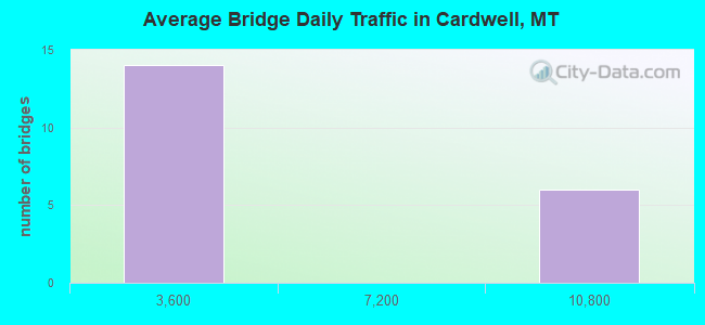
- 63,757Total average daily traffic
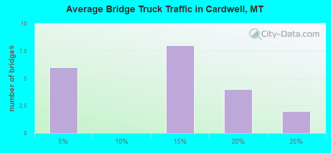
- 11,796Total average daily truck traffic
- National Bridge Inventory (NBI) Registered Bridges for Cardwell
- No street view available for this location
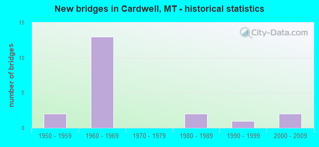
- New bridges - historical statistics
- 21950-1959
- 131960-1969
- 21980-1989
- 11990-1999
- 22000-2009
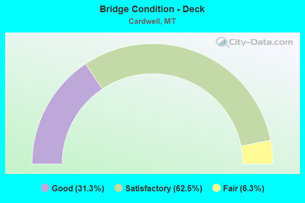
- Bridge Condition - Deck
- 31.3%Good
- 62.5%Satisfactory
- 6.3%Fair
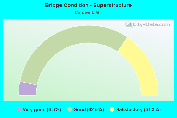
- Bridge Condition - Superstructure
- 6.3%Very good
- 62.5%Good
- 31.3%Satisfactory
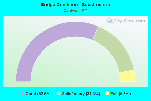
- Bridge Condition - Substructure
- 62.5%Good
- 31.3%Satisfactory
- 6.3%Fair
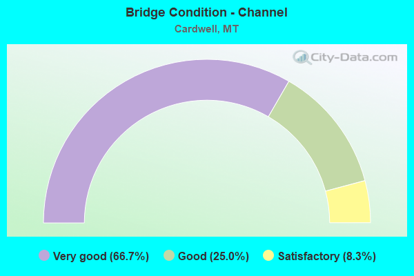
- Bridge Condition - Channel
- 66.7%Very good
- 25.0%Good
- 8.3%Satisfactory
Find on map >> Show street view
Structure Number: I00090253+03081, Location: 3.1M W CARDWELL (Lat: 45.875106, Lng: -112.014942), Route carried "on" structure: Interstate 90, Year Built: 1968, Status: Open, Structure Length: 6.58m (21.59ft), Average Daily Traffic: 8,716 (year 2020), Truck Traffic: 21%, Average Future Daily Traffic: 9,413 (year 2040), Design Load: HS 20, Features Intersected: P 69
Minimum Vertical Clearance: 30+ m (98+ ft), Kilometerpoint: 404.757, Lanes on structure: 2, Lanes under structure: 2, Base Highway Network: Yes, Owner: State Highway Agency, Approaching Roadway Width: 11.6m (38.1ft), Skew: 4 degrees, Material/Design: Prestressed concrete, Design/Construction: Stringer/Multi-beam, Number Of Spans In Main Unit: 3, Length of Maximum Span: 22.9m (75.1ft), Curb-To-Curb Width: 11.6m (38.1ft), Out-to-Out Width: 12.4m (40.7ft)
Condition: Deck: Satisfactory, Superstructure: Good, Substructure: Satisfactory, Operating Rating: 52.6 metric tons, Method Used To Determine Operating Rating: Load and Resistance Factor (LRFR), Inventory Rating: 40.8 metric tons, Method Used To Determine Inventory Rating: Load and Resistance Factor (LRFR), Structural Evaluation: Equal to present minimum criteria, Deck Geometry: Equal to present minimum criteria, Underclear: Meets minimum limits, Approach Roadway Alignment: Equal to present desirable criteria, Designated Inspection Frequency: Every 24 months, Inspection Date: October 2021, Deck Structure Type: Concrete Cast-file-Place
Find on map >> Show street view
Structure Number: I00090253+03082, Location: 3.1M W CARDWELL (Lat: 45.875375, Lng: -112.014692), Route carried "on" structure: Interstate 90, Year Built: 1968, Status: Open, Structure Length: 6.09m (19.98ft), Average Daily Traffic: 8,716 (year 2020), Truck Traffic: 21%, Average Future Daily Traffic: 9,413 (year 2040), Design Load: HS 20, Features Intersected: P 69
Minimum Vertical Clearance: 30+ m (98+ ft), Kilometerpoint: 404.960, Lanes on structure: 2, Lanes under structure: 2, Base Highway Network: Yes, Owner: State Highway Agency, Approaching Roadway Width: 11.6m (38.1ft), Skew: 4 degrees, Material/Design: Prestressed concrete, Design/Construction: Stringer/Multi-beam, Number Of Spans In Main Unit: 3, Length of Maximum Span: 22.9m (75.1ft), Curb-To-Curb Width: 11.6m (38.1ft), Out-to-Out Width: 12.4m (40.7ft)
Condition: Deck: Fair, Superstructure: Satisfactory, Substructure: Good, Operating Rating: 52.6 metric tons, Method Used To Determine Operating Rating: Load and Resistance Factor (LRFR), Inventory Rating: 33.6 metric tons, Method Used To Determine Inventory Rating: Load and Resistance Factor (LRFR), Structural Evaluation: Equal to present minimum criteria, Deck Geometry: Equal to present minimum criteria, Underclear: Meets minimum limits, Approach Roadway Alignment: Equal to present desirable criteria, Designated Inspection Frequency: Every 24 months, Inspection Date: October 2021, Deck Structure Type: Concrete Cast-file-Place
Find on map >> Show street view
Structure Number: I00090256+02931, Location: CARDWELL (Lat: 45.869692, Lng: -111.954583), Route carried "on" structure: Interstate 90, Year Built: 1968, Status: Open, Structure Length: 4.24m (13.91ft), Average Daily Traffic: 9,598 (year 2020), Truck Traffic: 19%, Average Future Daily Traffic: 10,366 (year 2040), Design Load: HS 20, Features Intersected: INT CARDWELL-S 359
Minimum Vertical Clearance: 30+ m (98+ ft), Kilometerpoint: 409.544, Lanes on structure: 2, Lanes under structure: 2, Base Highway Network: Yes, Owner: State Highway Agency, Approaching Roadway Width: 11.6m (38.1ft), Skew: 1 degrees, Material/Design: Prestressed concrete, Design/Construction: Stringer/Multi-beam, Number Of Spans In Main Unit: 3, Length of Maximum Span: 17.4m (57.1ft), Curb-To-Curb Width: 11.6m (38.1ft), Out-to-Out Width: 12.5m (41.0ft)
Condition: Deck: Satisfactory, Superstructure: Very good, Substructure: Good, Operating Rating: 54.4 metric tons, Method Used To Determine Operating Rating: Load and Resistance Factor (LRFR), Inventory Rating: 41.7 metric tons, Method Used To Determine Inventory Rating: Load and Resistance Factor (LRFR), Structural Evaluation: Better than present minimum criteria, Deck Geometry: Equal to present minimum criteria, Underclear: Somewhat better than minimum adequacy, Approach Roadway Alignment: Equal to present desirable criteria, Designated Inspection Frequency: Every 24 months, Inspection Date: December 2021, Deck Structure Type: Concrete Cast-file-Place
Find on map >> Show street view
Structure Number: I00090256+02932, Location: CARDWELL (Lat: 45.869897, Lng: -111.954628), Route carried "on" structure: Interstate 90, Year Built: 1968, Status: Open, Structure Length: 4.24m (13.91ft), Average Daily Traffic: 9,598 (year 2020), Truck Traffic: 19%, Average Future Daily Traffic: 10,366 (year 2040), Design Load: HS 20, Features Intersected: INT CARDWELL-S 359
Minimum Vertical Clearance: 30+ m (98+ ft), Kilometerpoint: 409.724, Lanes on structure: 2, Lanes under structure: 2, Base Highway Network: Yes, Owner: State Highway Agency, Approaching Roadway Width: 11.6m (38.1ft), Skew: 1 degrees, Material/Design: Prestressed concrete, Design/Construction: Stringer/Multi-beam, Number Of Spans In Main Unit: 3, Length of Maximum Span: 17.4m (57.1ft), Curb-To-Curb Width: 11.6m (38.1ft), Out-to-Out Width: 12.5m (41.0ft)
Condition: Deck: Satisfactory, Superstructure: Satisfactory, Substructure: Good, Operating Rating: 54.4 metric tons, Method Used To Determine Operating Rating: Load and Resistance Factor (LRFR), Inventory Rating: 41.7 metric tons, Method Used To Determine Inventory Rating: Load and Resistance Factor (LRFR), Structural Evaluation: Equal to present minimum criteria, Deck Geometry: Equal to present minimum criteria, Underclear: Somewhat better than minimum adequacy, Approach Roadway Alignment: Equal to present desirable criteria, Designated Inspection Frequency: Every 24 months, Inspection Date: December 2021, Deck Structure Type: Concrete Cast-file-Place
Find on map >> Show street view
Structure Number: I00090256+08671, Location: 0.6M E CARDWELL (Lat: 45.870261, Lng: -111.942758), Route carried "on" structure: Interstate 90, Year Built: 1968, Status: Open, Structure Length: 3.77m (12.37ft), Average Daily Traffic: 9,598 (year 2020), Truck Traffic: 19%, Average Future Daily Traffic: 10,366 (year 2040), Design Load: HS 20, Features Intersected: BOULDER RIVER
Minimum Vertical Clearance: 30+ m (98+ ft), Kilometerpoint: 410.465, Lanes on structure: 2, Base Highway Network: Yes, Owner: State Highway Agency, Approaching Roadway Width: 11.6m (38.1ft), Material/Design: Prestressed concrete, Design/Construction: Stringer/Multi-beam, Number Of Spans In Main Unit: 2, Length of Maximum Span: 17.1m (56.1ft), Curb-To-Curb Width: 11.6m (38.1ft), Out-to-Out Width: 11.6m (38.1ft)
Condition: Deck: Good, Superstructure: Good, Substructure: Good, Channel: Good, Operating Rating: 53.5 metric tons, Method Used To Determine Operating Rating: Load and Resistance Factor (LRFR), Inventory Rating: 41.7 metric tons, Method Used To Determine Inventory Rating: Load and Resistance Factor (LRFR), Structural Evaluation: Better than present minimum criteria, Deck Geometry: Equal to present minimum criteria, Waterway Adequacy: Equal to present desirable criteria, Approach Roadway Alignment: Equal to present desirable criteria, Designated Inspection Frequency: Every 24 months, Inspection Date: October 2021, Deck Structure Type: Concrete Cast-file-Place
Find on map >> Show street view
Structure Number: I00090256+08672, Location: 0.6M E CARDWELL (Lat: 45.870464, Lng: -111.942806), Route carried "on" structure: Interstate 90, Year Built: 1968, Status: Open, Structure Length: 3.47m (11.38ft), Average Daily Traffic: 9,598 (year 2020), Truck Traffic: 19%, Average Future Daily Traffic: 10,366 (year 2040), Design Load: HS 20, Features Intersected: BOULDER RIVER
Minimum Vertical Clearance: 30+ m (98+ ft), Kilometerpoint: 410.644, Lanes on structure: 2, Base Highway Network: Yes, Owner: State Highway Agency, Approaching Roadway Width: 11.6m (38.1ft), Material/Design: Prestressed concrete, Design/Construction: Stringer/Multi-beam, Number Of Spans In Main Unit: 2, Length of Maximum Span: 17.1m (56.1ft), Curb-To-Curb Width: 11.6m (38.1ft), Out-to-Out Width: 11.6m (38.1ft)
Condition: Deck: Satisfactory, Superstructure: Good, Substructure: Good, Channel: Good, Operating Rating: 53.5 metric tons, Method Used To Determine Operating Rating: Load and Resistance Factor (LRFR), Inventory Rating: 40.8 metric tons, Method Used To Determine Inventory Rating: Load and Resistance Factor (LRFR), Structural Evaluation: Better than present minimum criteria, Deck Geometry: Equal to present minimum criteria, Waterway Adequacy: Equal to present desirable criteria, Approach Roadway Alignment: Equal to present desirable criteria, Designated Inspection Frequency: Every 24 months, Inspection Date: October 2021, Deck Structure Type: Concrete Cast-file-Place
Find on map >> Show street view
Structure Number: L22249000+08001, Location: 1M E CARDWELL (Lat: 45.869992, Lng: -111.942717), Route carried "on" structure: ServiceState highway 2, Year Built: 1968, Status: Open, Structure Length: 3.47m (11.38ft), Average Daily Traffic: 290 (year 2020), Truck Traffic: 3%, Average Future Daily Traffic: 305 (year 2040), Design Load: HS 15, Features Intersected: BOULDER RIVER 064
Minimum Vertical Clearance: 30+ m (98+ ft), Kilometerpoint: 0.920, Lanes on structure: 2, Owner: State Highway Agency, Approaching Roadway Width: 11.3m (37.1ft), Material/Design: Prestressed concrete, Design/Construction: Stringer/Multi-beam, Number Of Spans In Main Unit: 2, Length of Maximum Span: 17.0m (55.8ft), Curb or Sidewalk Widths: Left: 0.4m (1.3ft), Right: 0.4m (1.3ft), Curb-To-Curb Width: 10.5m (34.4ft), Out-to-Out Width: 11.3m (37.1ft)
Condition: Deck: Satisfactory, Superstructure: Good, Substructure: Good, Channel: Very good, Operating Rating: 37.1 metric tons, Method Used To Determine Operating Rating: Allowable Stress (AS), Inventory Rating: 24.4 metric tons, Method Used To Determine Inventory Rating: Allowable Stress (AS), Structural Evaluation: Equal to present minimum criteria, Deck Geometry: Better than present minimum criteria, Waterway Adequacy: Equal to present desirable criteria, Approach Roadway Alignment: Equal to present desirable criteria, Designated Inspection Frequency: Every 24 months, Inspection Date: September 2021, Deck Structure Type: Concrete Cast-file-Place
Find on map >> Show street view
Structure Number: L22319001+00001, Location: 1M NE CARDWELL (Lat: 45.881494, Lng: -111.940803), Route carried "on" structure: County highway 22319, Year Built: 1983, Status: Posted for load, Structure Length: 2.41m (7.91ft), Average Daily Traffic: 100 (year 2022), Truck Traffic: 3%, Average Future Daily Traffic: 100 (year 2037), Features Intersected: BOULDER RIVER 009, Facility Carried by Structure: COTTONWOOD RD
Minimum Vertical Clearance: 30+ m (98+ ft), Kilometerpoint: 1.743, Lanes on structure: 1, Owner: County Highway Agency, Approaching Roadway Width: 6.1m (20.0ft), Material/Design: Prestressed concrete, Design/Construction: Tee Beam, Number Of Spans In Main Unit: 1, Length of Maximum Span: 23.8m (78.1ft), Curb-To-Curb Width: 4.9m (16.1ft), Out-to-Out Width: 4.9m (16.1ft)
Condition: Deck: Good, Superstructure: Good, Substructure: Good, Channel: Very good, Operating Rating: 32.7 metric tons, Method Used To Determine Operating Rating: Assigned rating based on Load Factor Design (LFD) reported in metric tons, Inventory Rating: 32.7 metric tons, Method Used To Determine Inventory Rating: Assigned rating based on Load Factor Design (LFD) reported in metric tons, Structural Evaluation: Better than present minimum criteria, Deck Geometry: High priority of corrective action, Waterway Adequacy: Equal to present desirable criteria, Approach Roadway Alignment: Equal to present minimum criteria, Length Of Structure Improvement: 3.20m (10.50ft), Designated Inspection Frequency: Every 24 months, Inspection Date: June 2021, Bridge Improvement Cost: $74,000, Roadway Improvement Cost: $37,000, Total Project Cost: $111,000, Deck Structure Type: Other
Find on map >> Show street view
Structure Number: L22522000+03001, Location: 3M W CARDWELL (Lat: 45.870761, Lng: -112.012911), Route carried "on" structure: County highway 22522, Year Built: 1991, Status: Open, Structure Length: 0.94m (3.08ft), Average Daily Traffic: 100 (year 2022), Truck Traffic: 3%, Average Future Daily Traffic: 100 (year 2037), Design Load: HS 20, Features Intersected: JEFFERSON SLOUGH 014, Facility Carried by Structure: TEBAY LN
Minimum Vertical Clearance: 30+ m (98+ ft), Kilometerpoint: 0.562, Lanes on structure: 2, Owner: County Highway Agency, Approaching Roadway Width: 7.9m (25.9ft), Material/Design: Prestressed concrete, Design/Construction: Tee Beam, Number Of Spans In Main Unit: 1, Length of Maximum Span: 6.7m (22.0ft), Curb or Sidewalk Widths: Left: 0.1m (0.3ft), Right: 0.1m (0.3ft), Curb-To-Curb Width: 8.3m (27.2ft), Out-to-Out Width: 8.8m (28.9ft)
Condition: Deck: Satisfactory, Superstructure: Good, Substructure: Satisfactory, Channel: Very good, Operating Rating: 32.7 metric tons, Method Used To Determine Operating Rating: Assigned rating based on Load Factor Design (LFD) reported in metric tons, Inventory Rating: 32.7 metric tons, Method Used To Determine Inventory Rating: Assigned rating based on Load Factor Design (LFD) reported in metric tons, Structural Evaluation: Equal to present minimum criteria, Deck Geometry: Equal to present minimum criteria, Waterway Adequacy: Equal to present desirable criteria, Approach Roadway Alignment: Equal to present desirable criteria, Designated Inspection Frequency: Every 24 months, Inspection Date: January 2021, Deck Structure Type: Concrete Precast Panels
Find on map >> Show street view
Structure Number: L22522001+00001, Location: 3M W CARDWELL (Lat: 45.859822, Lng: -112.013331), Route carried "on" structure: County highway 22522, Year Built: 2003, Status: Open, Structure Length: 2.20m (7.22ft), Average Daily Traffic: 100 (year 2022), Truck Traffic: 3%, Average Future Daily Traffic: 100 (year 2037), Design Load: HL 93, Features Intersected: JEF RIV OVERFLOW 013, Facility Carried by Structure: TEBAY LN
Minimum Vertical Clearance: 30+ m (98+ ft), Kilometerpoint: 1.794, Lanes on structure: 2, Owner: County Highway Agency, Approaching Roadway Width: 6.1m (20.0ft), Material/Design: Concrete continuous, Design/Construction: Slab, Number Of Spans In Main Unit: 3, Length of Maximum Span: 9.0m (29.5ft), Curb-To-Curb Width: 8.4m (27.6ft), Out-to-Out Width: 9.2m (30.2ft)
Condition: Deck: Satisfactory, Superstructure: Satisfactory, Substructure: Satisfactory, Channel: Very good, Operating Rating: 49.9 metric tons, Method Used To Determine Operating Rating: Load and Resistance Factor (LRFR), Inventory Rating: 39.0 metric tons, Method Used To Determine Inventory Rating: Load and Resistance Factor (LRFR), Structural Evaluation: Equal to present minimum criteria, Deck Geometry: Equal to present minimum criteria, Waterway Adequacy: Equal to present desirable criteria, Approach Roadway Alignment: Equal to present desirable criteria, Designated Inspection Frequency: Every 24 months, Underwater Inspection Frequency: Every 60 months, Inspection Date: September 2021, Underwater Inspection Date: September 2020, Deck Structure Type: Concrete Cast-file-Place, Wearing Surface/Protective System: Deck Protection: Epoxy Coated Reinforcing
Find on map >> Show street view
Structure Number: L22522001+02001, Location: 3M W CARDWELL (Lat: 45.856281, Lng: -112.013608), Route carried "on" structure: County highway 22522, Year Built: 1986, Status: Open, Structure Length: 7.16m (23.49ft), Average Daily Traffic: 100 (year 2022), Truck Traffic: 3%, Average Future Daily Traffic: 100 (year 2037), Design Load: HS 20, Features Intersected: JEFFERSON RIVER 012, Facility Carried by Structure: TEBAY LN
Minimum Vertical Clearance: 30+ m (98+ ft), Kilometerpoint: 2.172, Lanes on structure: 2, Owner: County Highway Agency, Approaching Roadway Width: 6.7m (22.0ft), Material/Design: Steel continuous, Design/Construction: Stringer/Multi-beam, Number Of Spans In Main Unit: 3, Length of Maximum Span: 27.4m (89.9ft), Curb-To-Curb Width: 7.1m (23.3ft), Out-to-Out Width: 8.0m (26.2ft)
Condition: Deck: Satisfactory, Superstructure: Good, Substructure: Satisfactory, Channel: Satisfactory, Operating Rating: 60.1 metric tons, Method Used To Determine Operating Rating: Load Factor (LF), Inventory Rating: 36.0 metric tons, Method Used To Determine Inventory Rating: Load Factor (LF), Structural Evaluation: Equal to present minimum criteria, Deck Geometry: Somewhat better than minimum adequacy, Waterway Adequacy: Equal to present desirable criteria, Approach Roadway Alignment: Better than present minimum criteria, Designated Inspection Frequency: Every 24 months, Underwater Inspection Frequency: Every 60 months, Inspection Date: January 2021, Underwater Inspection Date: September 2020, Deck Structure Type: Concrete Cast-file-Place
Find on map >> Show street view
Structure Number: L29062001+03001, Location: 5M S JEFFERSON ISLAND (Lat: 45.793861, Lng: -111.934119), Route carried "on" structure: County highway 29005, Year Built: 2008, Status: Open, Structure Length: 1.43m (4.69ft), Average Daily Traffic: 100 (year 2022), Truck Traffic: 3%, Average Future Daily Traffic: 100 (year 2037), Design Load: HS 20, Features Intersected: LWR S BOULDER RIVER 054, Facility Carried by Structure: S BOULDER RD
Minimum Vertical Clearance: 30+ m (98+ ft), Kilometerpoint: 1.382, Lanes on structure: 2, Owner: County Highway Agency, Approaching Roadway Width: 7.2m (23.6ft), Skew: 1 degrees, Material/Design: Prestressed concrete, Design/Construction: Tee Beam, Number Of Spans In Main Unit: 1, Length of Maximum Span: 13.7m (44.9ft), Curb-To-Curb Width: 7.3m (24.0ft), Out-to-Out Width: 7.9m (25.9ft)
Condition: Deck: Good, Superstructure: Good, Substructure: Good, Channel: Very good, Operating Rating: 46.6 metric tons, Method Used To Determine Operating Rating: Load Factor (LF), Inventory Rating: 34.7 metric tons, Method Used To Determine Inventory Rating: Load Factor (LF), Structural Evaluation: Better than present minimum criteria, Deck Geometry: Equal to present minimum criteria, Waterway Adequacy: Equal to present desirable criteria, Approach Roadway Alignment: Equal to present desirable criteria, Designated Inspection Frequency: Every 24 months, Inspection Date: April 2021, Deck Structure Type: Other
Find on map >> Show street view
Structure Number: S00359001+03461, Location: CARDWELL (Lat: 45.868317, Lng: -111.954300), Route carried "on" structure: State highway 359, Year Built: 1968, Status: Open, Structure Length: 3.40m (11.15ft), Average Daily Traffic: 922 (year 2020), Truck Traffic: 12%, Average Future Daily Traffic: 968 (year 2040), Design Load: HS 20, Features Intersected: JEFFERSON RIVER SLOUGH
Minimum Vertical Clearance: 30+ m (98+ ft), Kilometerpoint: 2.184, Lanes on structure: 2, Owner: State Highway Agency, Approaching Roadway Width: 11.0m (36.1ft), Material/Design: Prestressed concrete, Design/Construction: Stringer/Multi-beam, Number Of Spans In Main Unit: 2, Length of Maximum Span: 17.0m (55.8ft), Curb or Sidewalk Widths: Left: 0.1m (0.3ft), Right: 0.1m (0.3ft), Curb-To-Curb Width: 10.4m (34.1ft), Out-to-Out Width: 11.3m (37.1ft)
Condition: Deck: Satisfactory, Superstructure: Good, Substructure: Good, Channel: Very good, Operating Rating: 52.6 metric tons, Method Used To Determine Operating Rating: Load and Resistance Factor (LRFR), Inventory Rating: 35.4 metric tons, Method Used To Determine Inventory Rating: Load and Resistance Factor (LRFR), Structural Evaluation: Better than present minimum criteria, Deck Geometry: Equal to present minimum criteria, Waterway Adequacy: Equal to present desirable criteria, Approach Roadway Alignment: Equal to present desirable criteria, Designated Inspection Frequency: Every 24 months, Inspection Date: March 2020, Deck Structure Type: Concrete Cast-file-Place
Find on map >> Show street view
Structure Number: S00359002+02661, Location: JEFFERSON ISLAND (Lat: 45.854817, Lng: -111.950769), Route carried "on" structure: State highway 359, Year Built: 1967, Status: Open, Structure Length: 8.81m (28.90ft), Average Daily Traffic: 927 (year 2020), Truck Traffic: 11%, Average Future Daily Traffic: 973 (year 2040), Design Load: HS 15, Features Intersected: JEFFERSON RIVER
Minimum Vertical Clearance: 30+ m (98+ ft), Kilometerpoint: 3.702, Lanes on structure: 2, Owner: State Highway Agency, Approaching Roadway Width: 8.5m (27.9ft), Skew: 2 degrees, Material/Design: Prestressed concrete, Design/Construction: Stringer/Multi-beam, Number Of Spans In Main Unit: 3, Length of Maximum Span: 29.6m (97.1ft), Curb or Sidewalk Widths: Left: 0.8m (2.6ft), Right: 0.8m (2.6ft), Curb-To-Curb Width: 8.5m (27.9ft), Out-to-Out Width: 10.1m (33.1ft)
Condition: Deck: Satisfactory, Superstructure: Good, Substructure: Good, Channel: Good, Operating Rating: 48.1 metric tons, Method Used To Determine Operating Rating: Load and Resistance Factor (LRFR), Inventory Rating: 25.4 metric tons, Method Used To Determine Inventory Rating: Load and Resistance Factor (LRFR), Structural Evaluation: Equal to present minimum criteria, Deck Geometry: Somewhat better than minimum adequacy, Waterway Adequacy: Equal to present minimum criteria, Approach Roadway Alignment: Equal to present desirable criteria, Designated Inspection Frequency: Every 24 months, Underwater Inspection Frequency: Every 60 months, Inspection Date: October 2021, Underwater Inspection Date: September 2019, Deck Structure Type: Concrete Cast-file-Place
Find on map >> Show street view
Structure Number: S00359002+08211, Location: JEFFERSON ISLAND (Lat: 45.851700, Lng: -111.941425), Route carried "on" structure: State highway 359, Year Built: 1958, Status: Open, Structure Length: 1.16m (3.81ft), Average Daily Traffic: 927 (year 2020), Truck Traffic: 11%, Average Future Daily Traffic: 973 (year 2040), Design Load: HS 15, Features Intersected: BRICKER SPARROW DITCH
Minimum Vertical Clearance: 30+ m (98+ ft), Kilometerpoint: 4.604, Lanes on structure: 2, Owner: State Highway Agency, Approaching Roadway Width: 8.5m (27.9ft), Material/Design: Wood or Timber, Design/Construction: Stringer/Multi-beam, Number Of Spans In Main Unit: 2, Length of Maximum Span: 5.8m (19.0ft), Curb-To-Curb Width: 9.0m (29.5ft), Out-to-Out Width: 9.3m (30.5ft)
Condition: Deck: Good, Superstructure: Satisfactory, Substructure: Fair, Channel: Very good, Operating Rating: 32.7 metric tons, Method Used To Determine Operating Rating: Allowable Stress (AS), Inventory Rating: 22.7 metric tons, Method Used To Determine Inventory Rating: Allowable Stress (AS), Structural Evaluation: Somewhat better than minimum adequacy, Deck Geometry: Somewhat better than minimum adequacy, Waterway Adequacy: Equal to present desirable criteria, Approach Roadway Alignment: Equal to present minimum criteria, Designated Inspection Frequency: Every 24 months, Inspection Date: September 2020, Deck Structure Type: Wood or Timber, Wearing Surface/Protective System: Wearing Surface: Bituminous
Find on map >> Show street view
Structure Number: S00359006+02091, Location: 3M S JEFFERSON ISLAND (Lat: 45.805703, Lng: -111.927819), Route carried "on" structure: State highway 359, Year Built: 1958, Status: Open, Structure Length: 1.52m (4.99ft), Average Daily Traffic: 927 (year 2020), Truck Traffic: 11%, Average Future Daily Traffic: 973 (year 2040), Design Load: HS 15, Features Intersected: SOUTH BOULDER RIVER
Minimum Vertical Clearance: 30+ m (98+ ft), Kilometerpoint: 10.049, Lanes on structure: 2, Owner: State Highway Agency, Approaching Roadway Width: 7.6m (24.9ft), Material/Design: Wood or Timber, Design/Construction: Stringer/Multi-beam, Number Of Spans In Main Unit: 2, Length of Maximum Span: 7.6m (24.9ft), Curb-To-Curb Width: 7.6m (24.9ft), Out-to-Out Width: 7.9m (25.9ft)
Condition: Deck: Good, Superstructure: Satisfactory, Substructure: Satisfactory, Channel: Very good, Operating Rating: 49.0 metric tons, Method Used To Determine Operating Rating: Allowable Stress (AS), Inventory Rating: 34.5 metric tons, Method Used To Determine Inventory Rating: Allowable Stress (AS), Structural Evaluation: Equal to present minimum criteria, Deck Geometry: Meets minimum limits, Waterway Adequacy: Equal to present desirable criteria, Approach Roadway Alignment: Equal to present desirable criteria, Designated Inspection Frequency: Every 24 months, Inspection Date: September 2020, Deck Structure Type: Wood or Timber, Wearing Surface/Protective System: Wearing Surface: Bituminous
Find on map >> Show street view
Structure Number: I00090253+03081, Location: 31M W CARDWELL (Lat: 45.875106, Lng: -112.014942), Route carried "under" structure: State highway 69, Year Built: 1968, Structure Length: 0. m, Average Daily Traffic: 897 (year 2020), Truck Traffic: 11%, Features Intersected: P 69, Facility Carried by Structure: I 90 Eastbound
Minimum Vertical Clearance: 5.18m (16.99ft), Kilometerpoint: 6.837, Lanes on structure: 2, Lanes under structure: 2, Material/Design: Prestressed concrete, Design/Construction: Stringer/Multi-beam, Length of Maximum Span: 22.9m (75.1ft)
Find on map >> Show street view
Structure Number: I00090253+03082, Location: 31M W CARDWELL (Lat: 45.875375, Lng: -112.014692), Route carried "under" structure: State highway 69, Year Built: 1968, Structure Length: 0. m, Average Daily Traffic: 897 (year 2020), Truck Traffic: 11%, Features Intersected: P 69, Facility Carried by Structure: I 90 Westbound
Minimum Vertical Clearance: 4.67m (15.32ft), Kilometerpoint: 6.872, Lanes on structure: 2, Lanes under structure: 2, Material/Design: Prestressed concrete, Design/Construction: Stringer/Multi-beam, Length of Maximum Span: 22.9m (75.1ft)
Find on map >> Show street view
Structure Number: I00090256+02931, Location: CARDWELL (Lat: 45.869692, Lng: -111.954583), Route carried "under" structure: State highway 359, Year Built: 1968, Structure Length: 0. m, Average Daily Traffic: 823 (year 2020), Truck Traffic: 13%, Features Intersected: INT CARDWELL-S 359, Facility Carried by Structure: I 90
Minimum Vertical Clearance: 5.33m (17.49ft), Kilometerpoint: 2.029, Lanes on structure: 2, Lanes under structure: 2, Material/Design: Prestressed concrete, Design/Construction: Stringer/Multi-beam, Length of Maximum Span: 17.4m (57.1ft)
Find on map >> Show street view
Structure Number: I00090256+02932, Location: CARDWELL (Lat: 45.869897, Lng: -111.954628), Route carried "under" structure: State highway 359, Year Built: 1968, Structure Length: 0. m, Average Daily Traffic: 823 (year 2020), Truck Traffic: 13%, Features Intersected: INT CARDWELL-S 359, Facility Carried by Structure: I 90
Minimum Vertical Clearance: 4.65m (15.26ft), Kilometerpoint: 2.006, Lanes on structure: 2, Lanes under structure: 2, Material/Design: Prestressed concrete, Design/Construction: Stringer/Multi-beam, Length of Maximum Span: 17.4m (57.1ft)