Bridge Statistics for Carlton, Georgia (GA)
Condition, Traffic, Stress, Structural Evaluation, Project Costs
- National Bridge Inventory (NBI) Statistics
- 10Number of bridges
- 246ft / 75.4mTotal length
- $77,522,000Total costs
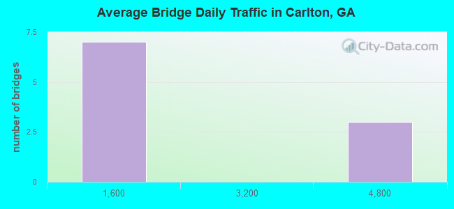
- 18,310Total average daily traffic
- 1,130Total average daily truck traffic
- 25,080Total future (year 2031) average daily traffic
- National Bridge Inventory (NBI) Registered Bridges for Carlton
- No street view available for this location
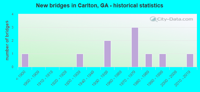
- New bridges - historical statistics
- 1Before 1900
- 11930-1939
- 21950-1959
- 31970-1979
- 11980-1989
- 11990-1999
- 12010-2019
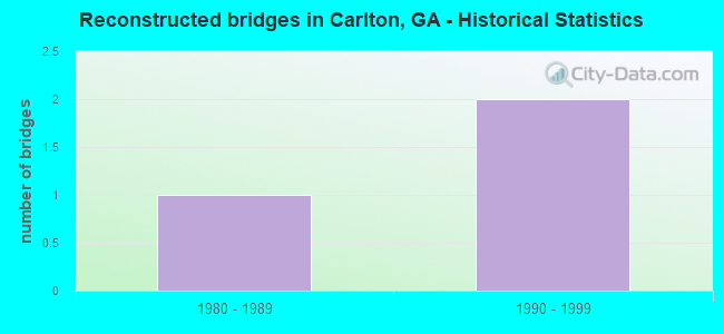
- Reconstructed bridges - Historical Statistics
- 11980-1989
- 21990-1999
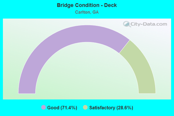
- Bridge Condition - Deck
- 71.4%Good
- 28.6%Satisfactory
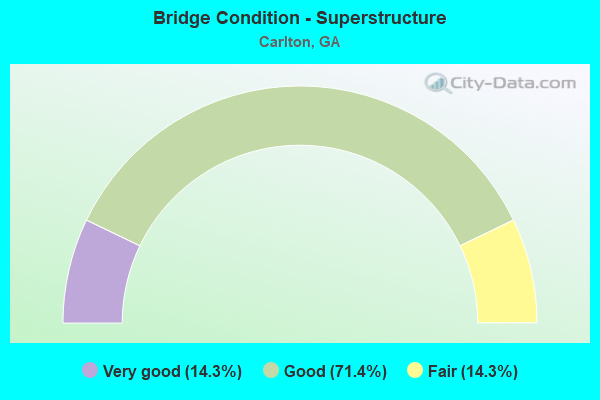
- Bridge Condition - Superstructure
- 14.3%Very good
- 71.4%Good
- 14.3%Fair
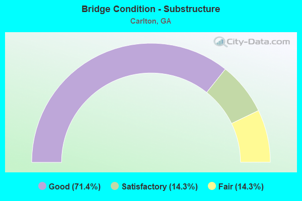
- Bridge Condition - Substructure
- 71.4%Good
- 14.3%Satisfactory
- 14.3%Fair
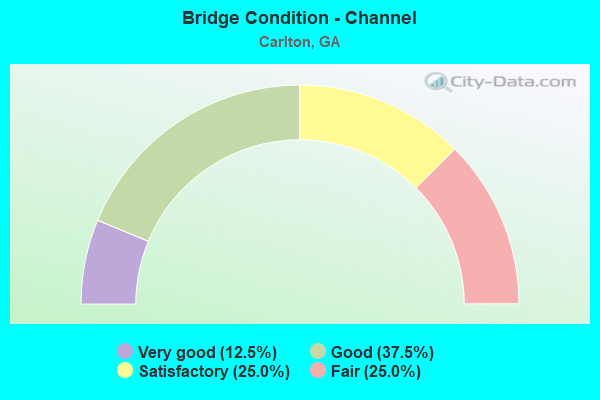
- Bridge Condition - Channel
- 12.5%Very good
- 37.5%Good
- 25.0%Satisfactory
- 25.0%Fair
Find on map >> Show street view
Structure Number: 1050004, Location: 6.8 MI SW OF ELBERTON (Lat: 34.076397, Lng: -82.975908), Route carried "on" structure: State highway 72, Year Built: 1975, Year Reconstructed: 1995, Status: Open, Structure Length: 1.13m (3.71ft), Average Daily Traffic: 4,420 (year 2011), Truck Traffic: 13%, Average Future Daily Traffic: 6,630 (year 2031), Design Load: HS 20+Mod, Features Intersected: LITTLE DOVE CREEK
Minimum Vertical Clearance: 30+ m (98+ ft), Kilometerpoint: 3.219, Lanes on structure: 5, Base Highway Network: Yes, Owner: State Highway Agency, Approaching Roadway Width: 21.3m (69.9ft), Skew: 9 degrees, Material/Design: Concrete, Design/Construction: Culvert, Number Of Spans In Main Unit: 3, Length of Maximum Span: 3.4m (11.2ft)
Condition: Channel: Satisfactory, Culverts: Good, Operating Rating: 59.8 metric tons, Method Used To Determine Operating Rating: Load Factor (LF), Inventory Rating: 36.2 metric tons, Method Used To Determine Inventory Rating: Load Factor (LF), Structural Evaluation: Better than present minimum criteria, Waterway Adequacy: Equal to present desirable criteria, Approach Roadway Alignment: Better than present minimum criteria, Designated Inspection Frequency: Every 24 months, Inspection Date: November 2020, Bridge Improvement Cost: $263,000, Roadway Improvement Cost: $26,000, Total Project Cost: $394,000
Find on map >> Show street view
Structure Number: 1950011, Location: 3 MI NE OF CARLTON (Lat: 34.074328, Lng: -83.003889), Route carried "on" structure: State highway 72, Year Built: 1935, Year Reconstructed: 1986, Status: Open, Structure Length: 16.98m (55.71ft), Average Daily Traffic: 4,690 (year 2012), Truck Traffic: 1%, Average Future Daily Traffic: 7,035 (year 2032), Design Load: H 15, Features Intersected: BROAD RIVER
Minimum Vertical Clearance: 30+ m (98+ ft), Kilometerpoint: 32.187, Lanes on structure: 2, Base Highway Network: Yes, Owner: State Highway Agency, Approaching Roadway Width: 12.8m (42.0ft), Material/Design: Concrete, Design/Construction: Arch - Deck, Number Of Spans In Main Unit: 5, Length of Maximum Span: 45.7m (149.9ft), Curb-To-Curb Width: 13.4m (44.0ft), Out-to-Out Width: 14.8m (48.6ft)
Condition: Deck: Good, Superstructure: Good, Substructure: Good, Channel: Good, Operating Rating: 39.9 metric tons, Method Used To Determine Operating Rating: Allowable Stress (AS), Inventory Rating: 17.2 metric tons, Method Used To Determine Inventory Rating: Allowable Stress (AS), Structural Evaluation: Meets minimum limits, Deck Geometry: Superior to present desirable criteria, Waterway Adequacy: Equal to present desirable criteria, Approach Roadway Alignment: Better than present minimum criteria, Designated Inspection Frequency: Every 24 months, Underwater Inspection Frequency: Every 60 months, Inspection Date: March 2021, Underwater Inspection Date: October 2021, Deck Structure Type: Concrete Cast-file-Place
Find on map >> Show street view
Structure Number: 1950021, Location: 8 MI N OF COMER (Lat: 34.181978, Lng: -83.146708), Route carried "on" structure: State highway 281, Year Built: 1956, Status: Open, Structure Length: 12.07m (39.60ft), Average Daily Traffic: 1,590 (year 2012), Truck Traffic: 1%, Average Future Daily Traffic: 2,385 (year 2032), Design Load: H 15, Features Intersected: BROAD RIVER
Minimum Vertical Clearance: 30+ m (98+ ft), Kilometerpoint: 6.437, Lanes on structure: 2, Base Highway Network: Yes, Owner: State Highway Agency, Approaching Roadway Width: 7.3m (24.0ft), Material/Design: Steel, Design/Construction: Stringer/Multi-beam, Number Of Spans In Main Unit: 6, Length of Maximum Span: 23.2m (76.1ft), Curb or Sidewalk Widths: Left: 0.6m (2.0ft), Right: 0.6m (2.0ft), Curb-To-Curb Width: 7.2m (23.6ft), Out-to-Out Width: 9.1m (29.9ft)
Condition: Deck: Satisfactory, Superstructure: Good, Substructure: Good, Channel: Good, Operating Rating: 30.8 metric tons, Method Used To Determine Operating Rating: Allowable Stress (AS), Inventory Rating: 17.2 metric tons, Method Used To Determine Inventory Rating: Allowable Stress (AS), Structural Evaluation: Meets minimum limits, Deck Geometry: High priority of corrective action, Waterway Adequacy: Equal to present desirable criteria, Approach Roadway Alignment: Better than present minimum criteria, Length Of Structure Improvement: 18.47m (60.60ft), Designated Inspection Frequency: Every 24 months, Underwater Inspection Frequency: Every 60 months, Inspection Date: March 2021, Underwater Inspection Date: October 2021, Bridge Improvement Cost: $128,000, Roadway Improvement Cost: $53,000, Total Project Cost: $330,000, Deck Structure Type: Concrete Cast-file-Place
Find on map >> Show street view
Structure Number: 1950022, Location: IN EAST CARLTON (Lat: 34.043708, Lng: -83.027328), Route carried "on" structure: County highway 1092, Year Built: 1978, Status: Posted for load, Structure Length: 3.66m (12.01ft), Average Daily Traffic: 1,100 (year 2012), Truck Traffic: 1%, Average Future Daily Traffic: 1,650 (year 2032), Design Load: HS 15, Features Intersected: HARTWELL RAILROAD, Facility Carried by Structure: LEXINGTON CIRCLE
Minimum Vertical Clearance: 30+ m (98+ ft), Kilometerpoint: 3.219, Lanes on structure: 2, Base Highway Network: Yes, Owner: County Highway Agency, Approaching Roadway Width: 6.1m (20.0ft), Skew: 2 degrees, Material/Design: Prestressed concrete, Design/Construction: Box Beam or Girders - Multiple, Number Of Spans In Main Unit: 3, Length of Maximum Span: 12.2m (40.0ft), Curb-To-Curb Width: 8.9m (29.2ft), Out-to-Out Width: 9.8m (32.2ft)
Condition: Deck: Good, Superstructure: Good, Substructure: Good, Operating Rating: 54.4 metric tons, Method Used To Determine Operating Rating: Load Factor (LF), Inventory Rating: 32.6 metric tons, Method Used To Determine Inventory Rating: Load Factor (LF), Structural Evaluation: Better than present minimum criteria, Deck Geometry: Somewhat better than minimum adequacy, Underclear: Somewhat better than minimum adequacy, Approach Roadway Alignment: Equal to present desirable criteria, Designated Inspection Frequency: Every 24 months, Inspection Date: March 2021, Deck Structure Type: Concrete Precast Panels, Wearing Surface/Protective System: Wearing Surface: Bituminous
Find on map >> Show street view
Structure Number: 1955024, Location: 1.5 MI N OF CARLTON (Lat: 34.065539, Lng: -83.051358), Route carried "on" structure: County highway 287, Year Built: 1991, Status: Open, Structure Length: 1.37m (4.49ft), Average Daily Traffic: 40 (year 2012), Truck Traffic: 1%, Average Future Daily Traffic: 60 (year 2032), Design Load: HS 20+Mod, Features Intersected: FORK CREEK, Facility Carried by Structure: NEW TOWN CHURCH RO
Minimum Vertical Clearance: 30+ m (98+ ft), Kilometerpoint: 6.437, Lanes on structure: 2, Base Highway Network: Yes, Owner: County Highway Agency, Approaching Roadway Width: 5.5m (18.0ft), Skew: 4 degrees, Material/Design: Concrete, Design/Construction: Culvert, Number Of Spans In Main Unit: 3, Length of Maximum Span: 4.3m (14.1ft)
Condition: Channel: Fair, Culverts: Good, Operating Rating: 55.3 metric tons, Method Used To Determine Operating Rating: Field evaluation and documented engineering judgment, Inventory Rating: 32.6 metric tons, Method Used To Determine Inventory Rating: Field evaluation and documented engineering judgment, Structural Evaluation: Better than present minimum criteria, Waterway Adequacy: Somewhat better than minimum adequacy, Approach Roadway Alignment: Equal to present minimum criteria, Designated Inspection Frequency: Every 24 months, Inspection Date: March 2021
Find on map >> Show street view
Structure Number: 1955025, Location: 2.5 MI E OF CARLTON (Lat: 34.052819, Lng: -83.004097), Route carried "on" structure: County highway 294, Year Built: 1974, Status: Open, Structure Length: 4.02m (13.19ft), Average Daily Traffic: 490 (year 2012), Truck Traffic: 1%, Average Future Daily Traffic: 735 (year 2032), Design Load: HS 15, Features Intersected: HARTWELL RAILROAD, Facility Carried by Structure: BERKLEY ROAD
Minimum Vertical Clearance: 30+ m (98+ ft), Kilometerpoint: 1.609, Lanes on structure: 2, Base Highway Network: Yes, Owner: County Highway Agency, Approaching Roadway Width: 6.4m (21.0ft), Skew: 1 degrees, Material/Design: Steel, Design/Construction: Stringer/Multi-beam, Number Of Spans In Main Unit: 3, Length of Maximum Span: 13.4m (44.0ft), Curb or Sidewalk Widths: Left: 0.2m (0.7ft), Right: 0.2m (0.7ft), Curb-To-Curb Width: 8.8m (28.9ft), Out-to-Out Width: 10.0m (32.8ft)
Condition: Deck: Good, Superstructure: Good, Substructure: Good, Operating Rating: 89.8 metric tons, Method Used To Determine Operating Rating: Load Factor (LF), Inventory Rating: 57.1 metric tons, Method Used To Determine Inventory Rating: Load Factor (LF), Structural Evaluation: Better than present minimum criteria, Deck Geometry: Somewhat better than minimum adequacy, Underclear: Better than present minimum criteria, Approach Roadway Alignment: Better than present minimum criteria, Designated Inspection Frequency: Every 24 months, Inspection Date: March 2021, Deck Structure Type: Concrete Cast-file-Place
Find on map >> Show street view
Structure Number: 1955027, Location: 3.5 MI E OF COMER (Lat: 34.066489, Lng: -83.063289), Route carried "on" structure: County highway 304, Year Built: 1989, Status: Open, Structure Length: 1.71m (5.61ft), Average Daily Traffic: 20 (year 2012), Truck Traffic: 1%, Average Future Daily Traffic: 30 (year 2032), Design Load: HS 20+Mod, Features Intersected: FORK CREEK, Facility Carried by Structure: DUCKWORTH-BROWN RD
Minimum Vertical Clearance: 30+ m (98+ ft), Kilometerpoint: 1.609, Lanes on structure: 2, Base Highway Network: Yes, Owner: County Highway Agency, Approaching Roadway Width: 5.5m (18.0ft), Skew: 1 degrees, Material/Design: Concrete, Design/Construction: Culvert, Number Of Spans In Main Unit: 5, Length of Maximum Span: 3.0m (9.8ft)
Condition: Channel: Fair, Culverts: Good, Operating Rating: 55.3 metric tons, Method Used To Determine Operating Rating: Field evaluation and documented engineering judgment, Inventory Rating: 32.6 metric tons, Method Used To Determine Inventory Rating: Field evaluation and documented engineering judgment, Structural Evaluation: Better than present minimum criteria, Waterway Adequacy: Equal to present desirable criteria, Approach Roadway Alignment: Somewhat better than minimum adequacy, Designated Inspection Frequency: Every 24 months, Inspection Date: March 2021
Find on map >> Show street view
Structure Number: 1955065, Location: 3 MI NE OF CARLTON (Lat: 34.073889, Lng: -83.005031), Route carried "on" structure: State highway 72, Year Built: 2017, Status: Open, Structure Length: 16.89m (55.41ft), Average Daily Traffic: 4,690 (year 2012), Truck Traffic: 10%, Average Future Daily Traffic: 4,650 (year 2035), Design Load: HS 20+Mod, Features Intersected: BROAD RIVER
Minimum Vertical Clearance: 30+ m (98+ ft), Kilometerpoint: 32.187, Lanes on structure: 2, Base Highway Network: Yes, Owner: State Highway Agency, Approaching Roadway Width: 11.6m (38.1ft), Material/Design: Prestressed concrete, Design/Construction: Stringer/Multi-beam, Number Of Spans In Main Unit: 8, Length of Maximum Span: 22.9m (75.1ft), Curb-To-Curb Width: 11.6m (38.1ft), Out-to-Out Width: 12.5m (41.0ft)
Condition: Deck: Good, Superstructure: Very good, Substructure: Good, Channel: Very good, Operating Rating: 68.0 metric tons, Method Used To Determine Operating Rating: Load Factor (LF), Inventory Rating: 38.1 metric tons, Method Used To Determine Inventory Rating: Load Factor (LF), Structural Evaluation: Better than present minimum criteria, Deck Geometry: Better than present minimum criteria, Waterway Adequacy: Superior to present desirable criteria, Approach Roadway Alignment: Equal to present desirable criteria, Length Of Structure Improvement: 20.27m (66.50ft), Designated Inspection Frequency: Every 24 months, Underwater Inspection Frequency: Every 60 months, Inspection Date: March 2021, Underwater Inspection Date: October 2021, Bridge Improvement Cost: $49,210,000, Roadway Improvement Cost: $4,921,000, Total Project Cost: $73,815,000 ( Estimate for 2017), Deck Structure Type: Concrete Cast-file-Place
Find on map >> Show street view
Structure Number: 2210017, Location: 12.5 MI NE OF LEXINGTON (Lat: 34.031739, Lng: -83.009247), Route carried "on" structure: County highway 1092, Year Built: 1955, Status: Open, Structure Length: 10.06m (33.01ft), Average Daily Traffic: 780 (year 2011), Truck Traffic: 1%, Average Future Daily Traffic: 1,170 (year 2031), Design Load: H 15, Features Intersected: SOUTH FORK BROAD RIVER, Facility Carried by Structure: LEVINGTON-GARLSTON
Minimum Vertical Clearance: 30+ m (98+ ft), Kilometerpoint: 19.312, Lanes on structure: 2, Base Highway Network: Yes, Owner: County Highway Agency, Approaching Roadway Width: 6.1m (20.0ft), Material/Design: Steel, Design/Construction: Stringer/Multi-beam, Number Of Spans In Main Unit: 5, Length of Maximum Span: 24.4m (80.1ft), Curb or Sidewalk Widths: Left: 0.6m (2.0ft), Right: 0.6m (2.0ft), Curb-To-Curb Width: 7.3m (24.0ft), Out-to-Out Width: 9.8m (32.2ft)
Condition: Deck: Good, Superstructure: Good, Substructure: Fair, Channel: Good, Operating Rating: 47.1 metric tons, Method Used To Determine Operating Rating: Load Factor (LF), Inventory Rating: 29.9 metric tons, Method Used To Determine Inventory Rating: Load Factor (LF), Structural Evaluation: Somewhat better than minimum adequacy, Deck Geometry: Meets minimum limits, Waterway Adequacy: Equal to present desirable criteria, Approach Roadway Alignment: Equal to present minimum criteria, Length Of Structure Improvement: 16.49m (54.10ft), Designated Inspection Frequency: Every 24 months, Underwater Inspection Frequency: Every 60 months, Inspection Date: November 2020, Underwater Inspection Date: October 2021, Bridge Improvement Cost: $1,289,000, Roadway Improvement Cost: $129,000, Total Project Cost: $1,934,000, Deck Structure Type: Concrete Cast-file-Place
Find on map >> Show street view
Structure Number: 2215013, Location: 10.9 MI NE OF LEXINGTON (Lat: 34.026869, Lng: -83.074869), Route carried "on" structure: County highway 206, Year Built: 1885, Year Reconstructed: 1998, Status: Posted for load, Structure Length: 7.50m (24.61ft), Average Daily Traffic: 490 (year 2012), Truck Traffic: 1%, Average Future Daily Traffic: 735 (year 2032), Features Intersected: SOUTH FORK BROAD RIVER, Facility Carried by Structure: WATSON MILL ROAD
Minimum Vertical Clearance: 2.89m (9.48ft), Kilometerpoint: 3.219, Lanes on structure: 1, Base Highway Network: Yes, Owner: State Park, Forest, or Reservation Agency, Approaching Roadway Width: 5.5m (18.0ft), Material/Design: Wood or Timber, Design/Construction: Truss - Thru, Number Of Spans In Main Unit: 5, Length of Maximum Span: 21.9m (71.9ft), Curb-To-Curb Width: 3.4m (11.2ft), Out-to-Out Width: 5.5m (18.0ft)
Condition: Deck: Satisfactory, Superstructure: Fair, Substructure: Satisfactory, Channel: Satisfactory, Operating Rating: 7.2 metric tons, Method Used To Determine Operating Rating: Allowable Stress (AS), Inventory Rating: 5.4 metric tons, Method Used To Determine Inventory Rating: Allowable Stress (AS), Structural Evaluation: High priority of replacement, Deck Geometry: High priority of replacement, Waterway Adequacy: Equal to present minimum criteria, Approach Roadway Alignment: Equal to present minimum criteria, Bridge Posting: Required (Relationship of Operating Rating to Maximum Legal Load: > 39.9% below), Length Of Structure Improvement: 13.75m (45.11ft), Designated Inspection Frequency: Every 24 months, Underwater Inspection Frequency: Every 60 months, Other Special Inspection Frequency: Every 24 months, Inspection Date: October 2021, Underwater Inspection Date: October 2021, Other Special Inspection Date: October 2021, Bridge Improvement Cost: $699,000, Roadway Improvement Cost: $70,000, Total Project Cost: $1,049,000, Deck Structure Type: Wood or Timber, Wearing Surface/Protective System: Wearing Surface: Wood or Timber