Bridge Statistics for Carnuel, New Mexico (NM)
Condition, Traffic, Stress, Structural Evaluation, Project Costs
- National Bridge Inventory (NBI) Statistics
- 17Number of bridges
- 233ft / 71.5mTotal length
- $2,165,000Total costs
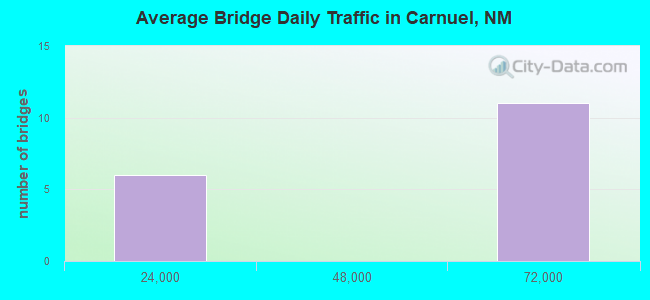
- 734,304Total average daily traffic
- 94,254Total average daily truck traffic
- National Bridge Inventory (NBI) Registered Bridges for Carnuel
- No street view available for this location
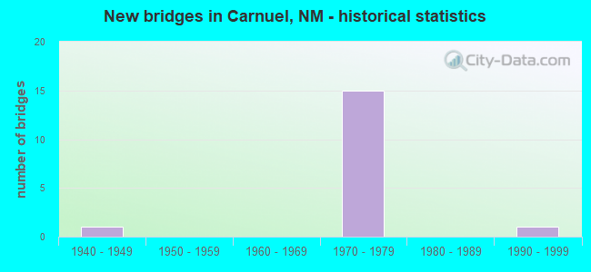
- New bridges - historical statistics
- 11940-1949
- 151970-1979
- 11990-1999
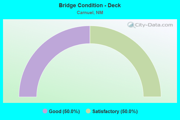
- Bridge Condition - Deck
- 50.0%Good
- 50.0%Satisfactory
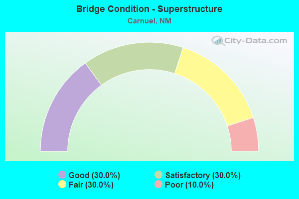
- Bridge Condition - Superstructure
- 30.0%Good
- 30.0%Satisfactory
- 30.0%Fair
- 10.0%Poor
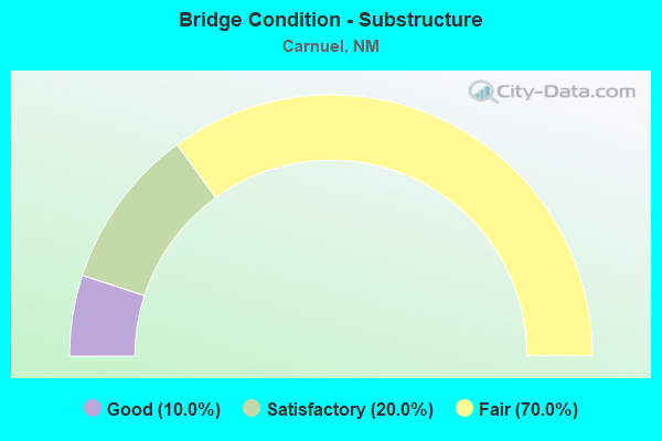
- Bridge Condition - Substructure
- 10.0%Good
- 20.0%Satisfactory
- 70.0%Fair
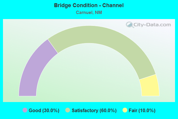
- Bridge Condition - Channel
- 30.0%Good
- 60.0%Satisfactory
- 10.0%Fair
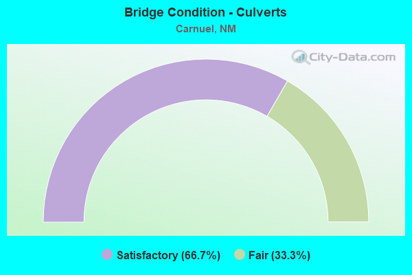
- Bridge Condition - Culverts
- 66.7%Satisfactory
- 33.3%Fair
Find on map >> Show street view
Structure Number: 554, Location: 0.3 MI E OF I-40/CARNUEL (Lat: 35.063747, Lng: -106.461214), Route carried "on" structure: State highway 333, Year Built: 1949, Status: Open, Structure Length: 0.82m (2.69ft), Average Daily Traffic: 4,101 (year 2020), Truck Traffic: 6%, Average Future Daily Traffic: 6,684 (year 2040), Design Load: HS 20, Features Intersected: UNNAMED WATERWAY
Minimum Vertical Clearance: 30+ m (98+ ft), Kilometerpoint: 3.219, Lanes on structure: 4, Owner: State Highway Agency, Approaching Roadway Width: 25.0m (82.0ft), Skew: 10 degrees, Material/Design: Concrete continuous, Design/Construction: Culvert, Number Of Spans In Main Unit: 3, Length of Maximum Span: 2.4m (7.9ft)
Condition: Channel: Satisfactory, Culverts: Satisfactory, Operating Rating: 53.5 metric tons, Method Used To Determine Operating Rating: Load Factor (LF), Inventory Rating: 32.4 metric tons, Method Used To Determine Inventory Rating: Load Factor (LF), Structural Evaluation: Equal to present minimum criteria, Waterway Adequacy: Better than present minimum criteria, Approach Roadway Alignment: Equal to present desirable criteria, Designated Inspection Frequency: Every 48 months, Inspection Date: June 2018
Find on map >> Show street view
Structure Number: 764, Location: 11.6 Mi E Jct I-25/I-40 (Lat: 35.063792, Lng: -106.437325), Route carried "on" structure: Interstate 40, Year Built: 1978, Year Reconstructed: 2007, Status: Open, Structure Length: 6.04m (19.82ft), Average Daily Traffic: 65,209 (year 2020), Truck Traffic: 13%, Average Future Daily Traffic: 120,169 (year 2040), Design Load: HS 20, Features Intersected: Tijeras Arroyo
Minimum Vertical Clearance: 30+ m (98+ ft), Kilometerpoint: 275.166, Lanes on structure: 3, Base Highway Network: Yes, Owner: State Highway Agency, Approaching Roadway Width: 16.6m (54.5ft), Skew: 13 degrees, Material/Design: Prestressed concrete, Design/Construction: Stringer/Multi-beam, Number Of Spans In Main Unit: 3, Length of Maximum Span: 19.5m (64.0ft), Curb-To-Curb Width: 16.6m (54.5ft), Out-to-Out Width: 17.4m (57.1ft)
Condition: Deck: Satisfactory, Superstructure: Satisfactory, Substructure: Fair, Channel: Good, Operating Rating: 53.5 metric tons, Method Used To Determine Operating Rating: Load Factor (LF), Inventory Rating: 32.4 metric tons, Method Used To Determine Inventory Rating: Load Factor (LF), Structural Evaluation: Somewhat better than minimum adequacy, Deck Geometry: Equal to present minimum criteria, Waterway Adequacy: Superior to present desirable criteria, Approach Roadway Alignment: Equal to present desirable criteria, Length Of Structure Improvement: 6.04m (19.82ft), Designated Inspection Frequency: Every 24 months, Inspection Date: June 2020, Bridge Improvement Cost: $564,000, Roadway Improvement Cost: $56,000, Total Project Cost: $846,000 ( Estimate for 2020), Deck Structure Type: Concrete Cast-file-Place, Wearing Surface/Protective System: Wearing Surface: Epoxy Overlay, Deck Protection: Epoxy Coated Reinforcing
Find on map >> Show street view
Structure Number: 7644, Location: 12.4 M E Jct I-25/I-40 (Lat: 35.065803, Lng: -106.424436), Route carried "on" structure: Interstate 40, Year Built: 1978, Status: Open, Structure Length: 6.49m (21.29ft), Average Daily Traffic: 65,209 (year 2020), Truck Traffic: 13%, Average Future Daily Traffic: 120,169 (year 2040), Design Load: HS 20, Features Intersected: NM-333
Minimum Vertical Clearance: 30+ m (98+ ft), Kilometerpoint: 276.389, Lanes on structure: 3, Lanes under structure: 3, Base Highway Network: Yes, Owner: State Highway Agency, Approaching Roadway Width: 16.5m (54.1ft), Skew: 15 degrees, Material/Design: Prestressed concrete, Design/Construction: Stringer/Multi-beam, Number Of Spans In Main Unit: 3, Length of Maximum Span: 28.3m (92.8ft), Curb-To-Curb Width: 16.6m (54.5ft), Out-to-Out Width: 17.4m (57.1ft)
Condition: Deck: Good, Superstructure: Fair, Substructure: Fair, Operating Rating: 53.5 metric tons, Method Used To Determine Operating Rating: Load Factor (LF), Inventory Rating: 32.4 metric tons, Method Used To Determine Inventory Rating: Load Factor (LF), Structural Evaluation: Somewhat better than minimum adequacy, Deck Geometry: Equal to present minimum criteria, Underclear: Superior to present desirable criteria, Approach Roadway Alignment: Equal to present desirable criteria, Designated Inspection Frequency: Every 24 months, Inspection Date: June 2020, Deck Structure Type: Concrete Cast-file-Place, Wearing Surface/Protective System: Wearing Surface: Epoxy Overlay, Deck Protection: Epoxy Coated Reinforcing
Find on map >> Show street view
Structure Number: 7645, Location: 12.4 M E Jct I-25/1-40 (Lat: 35.065914, Lng: -106.424858), Route carried "on" structure: Interstate 40, Year Built: 1978, Status: Open, Structure Length: 6.22m (20.41ft), Average Daily Traffic: 65,209 (year 2020), Truck Traffic: 13%, Average Future Daily Traffic: 120,169 (year 2040), Design Load: HS 20, Features Intersected: NM-333
Minimum Vertical Clearance: 30+ m (98+ ft), Kilometerpoint: 276.389, Lanes on structure: 3, Lanes under structure: 3, Base Highway Network: Yes, Owner: State Highway Agency, Approaching Roadway Width: 16.7m (54.8ft), Skew: 15 degrees, Material/Design: Prestressed concrete, Design/Construction: Stringer/Multi-beam, Number Of Spans In Main Unit: 3, Length of Maximum Span: 28.3m (92.8ft), Curb-To-Curb Width: 16.7m (54.8ft), Out-to-Out Width: 17.4m (57.1ft)
Condition: Deck: Good, Superstructure: Good, Substructure: Fair, Operating Rating: 53.5 metric tons, Method Used To Determine Operating Rating: Load Factor (LF), Inventory Rating: 32.4 metric tons, Method Used To Determine Inventory Rating: Load Factor (LF), Structural Evaluation: Somewhat better than minimum adequacy, Deck Geometry: Equal to present minimum criteria, Underclear: Superior to present desirable criteria, Approach Roadway Alignment: Equal to present desirable criteria, Designated Inspection Frequency: Every 24 months, Inspection Date: June 2020, Deck Structure Type: Concrete Cast-file-Place, Wearing Surface/Protective System: Wearing Surface: Epoxy Overlay, Deck Protection: Epoxy Coated Reinforcing
Find on map >> Show street view
Structure Number: 7653, Location: 9.8 M E Jct I-25/I-40 (Lat: 35.062939, Lng: -106.467889), Route carried "on" structure: State highway 333, Year Built: 1978, Status: Open, Structure Length: 14.78m (48.49ft), Average Daily Traffic: 4,101 (year 2020), Truck Traffic: 6%, Average Future Daily Traffic: 6,684 (year 2040), Design Load: HS 20, Features Intersected: I-40 EBL and WBL
Minimum Vertical Clearance: 30+ m (98+ ft), Kilometerpoint: 2.575, Lanes on structure: 2, Lanes under structure: 6, Owner: State Highway Agency, Approaching Roadway Width: 13.1m (43.0ft), Skew: 5 degrees, Material/Design: Steel continuous, Design/Construction: Stringer/Multi-beam, Number Of Spans In Main Unit: 4, Length of Maximum Span: 52.4m (171.9ft), Curb-To-Curb Width: 13.5m (44.3ft), Out-to-Out Width: 14.3m (46.9ft)
Condition: Deck: Good, Superstructure: Good, Substructure: Satisfactory, Operating Rating: 64.8 metric tons, Method Used To Determine Operating Rating: Load Factor (LF), Inventory Rating: 32.4 metric tons, Method Used To Determine Inventory Rating: Load Factor (LF), Structural Evaluation: Equal to present minimum criteria, Deck Geometry: Superior to present desirable criteria, Underclear: High priority of corrective action, Approach Roadway Alignment: Equal to present desirable criteria, Designated Inspection Frequency: Every 24 months, Other Special Inspection Frequency: Every 60 months, Inspection Date: August 2020, Other Special Inspection Date: August 2020, Deck Structure Type: Concrete Cast-file-Place
Find on map >> Show street view
Structure Number: 7654, Location: 9.9 Mi E of Jct I-25/I-40 (Lat: 35.061956, Lng: -106.465656), Route carried "on" structure: State highway 4053, Year Built: 1978, Status: Open, Structure Length: 6.74m (22.11ft), Average Daily Traffic: 334 (year 2020), Truck Traffic: 7%, Average Future Daily Traffic: 545 (year 2040), Design Load: HS 20, Features Intersected: Tijeras Arroyo
Minimum Vertical Clearance: 30+ m (98+ ft), Kilometerpoint: 0.563, Lanes on structure: 2, Owner: State Highway Agency, Approaching Roadway Width: 10.5m (34.4ft), Skew: 2 degrees, Material/Design: Prestressed concrete continuous, Design/Construction: Stringer/Multi-beam, Number Of Spans In Main Unit: 3, Length of Maximum Span: 24.4m (80.1ft), Curb-To-Curb Width: 11.0m (36.1ft), Out-to-Out Width: 11.9m (39.0ft)
Condition: Deck: Good, Superstructure: Good, Substructure: Satisfactory, Channel: Good, Operating Rating: 53.5 metric tons, Method Used To Determine Operating Rating: Load Factor (LF), Inventory Rating: 32.4 metric tons, Method Used To Determine Inventory Rating: Load Factor (LF), Structural Evaluation: Equal to present minimum criteria, Deck Geometry: Equal to present desirable criteria, Waterway Adequacy: Equal to present minimum criteria, Approach Roadway Alignment: Equal to present desirable criteria, Designated Inspection Frequency: Every 24 months, Inspection Date: May 2020, Deck Structure Type: Concrete Cast-file-Place, Wearing Surface/Protective System: Deck Protection: Epoxy Coated Reinforcing
Find on map >> Show street view
Structure Number: 7655, Location: 9.9 Mi E of Jct I-25/I-40 (Lat: 35.062103, Lng: -106.465506), Route carried "on" structure: Interstate 40, Year Built: 1978, Status: Open, Structure Length: 7.32m (24.02ft), Average Daily Traffic: 65,209 (year 2020), Truck Traffic: 13%, Average Future Daily Traffic: 120,169 (year 2040), Design Load: HS 20, Features Intersected: Tijeras Arroyo
Minimum Vertical Clearance: 30+ m (98+ ft), Kilometerpoint: 272.542, Lanes on structure: 3, Base Highway Network: Yes, Owner: State Highway Agency, Approaching Roadway Width: 16.2m (53.1ft), Skew: 12 degrees, Material/Design: Prestressed concrete, Design/Construction: Stringer/Multi-beam, Number Of Spans In Main Unit: 3, Length of Maximum Span: 23.8m (78.1ft), Curb-To-Curb Width: 16.5m (54.1ft), Out-to-Out Width: 17.4m (57.1ft)
Condition: Deck: Satisfactory, Superstructure: Poor, Substructure: Fair, Channel: Satisfactory, Operating Rating: 44.7 metric tons, Method Used To Determine Operating Rating: Load Factor (LF), Inventory Rating: 26.8 metric tons, Method Used To Determine Inventory Rating: Load Factor (LF), Structural Evaluation: Meets minimum limits, Deck Geometry: Equal to present minimum criteria, Waterway Adequacy: Superior to present desirable criteria, Approach Roadway Alignment: Equal to present desirable criteria, Designated Inspection Frequency: Every 12 months, Inspection Date: October 2021, Deck Structure Type: Concrete Cast-file-Place, Wearing Surface/Protective System: Wearing Surface: Epoxy Overlay, Deck Protection: Epoxy Coated Reinforcing
Find on map >> Show street view
Structure Number: 7656, Location: 9.9 Mi E of Jct I-25/I-40 (Lat: 35.062314, Lng: -106.465289), Route carried "on" structure: Interstate 40, Year Built: 1978, Status: Open, Structure Length: 7.35m (24.11ft), Average Daily Traffic: 65,209 (year 2020), Truck Traffic: 13%, Average Future Daily Traffic: 120,169 (year 2040), Design Load: HS 20, Features Intersected: Tijeras Arroyo
Minimum Vertical Clearance: 30+ m (98+ ft), Kilometerpoint: 272.542, Lanes on structure: 3, Base Highway Network: Yes, Owner: State Highway Agency, Approaching Roadway Width: 16.8m (55.1ft), Skew: 13 degrees, Material/Design: Prestressed concrete, Design/Construction: Stringer/Multi-beam, Number Of Spans In Main Unit: 3, Length of Maximum Span: 23.8m (78.1ft), Curb-To-Curb Width: 16.6m (54.5ft), Out-to-Out Width: 17.4m (57.1ft)
Condition: Deck: Satisfactory, Superstructure: Fair, Substructure: Fair, Channel: Satisfactory, Operating Rating: 44.7 metric tons, Method Used To Determine Operating Rating: Load Factor (LF), Inventory Rating: 26.8 metric tons, Method Used To Determine Inventory Rating: Load Factor (LF), Structural Evaluation: Somewhat better than minimum adequacy, Deck Geometry: Equal to present minimum criteria, Waterway Adequacy: Superior to present desirable criteria, Approach Roadway Alignment: Equal to present desirable criteria, Designated Inspection Frequency: Every 12 months, Inspection Date: October 2021, Deck Structure Type: Concrete Cast-file-Place, Wearing Surface/Protective System: Deck Protection: Epoxy Coated Reinforcing
Find on map >> Show street view
Structure Number: 7658, Location: 10.6 Mi E Jct I-25/I-40 (Lat: 35.061086, Lng: -106.453997), Route carried "on" structure: Interstate 40, Year Built: 1978, Year Reconstructed: 2009, Status: Open, Structure Length: 5.70m (18.70ft), Average Daily Traffic: 65,209 (year 2020), Truck Traffic: 13%, Average Future Daily Traffic: 120,169 (year 2040), Design Load: HS 20, Features Intersected: Tijeras Arroyo
Minimum Vertical Clearance: 30+ m (98+ ft), Kilometerpoint: 273.508, Lanes on structure: 3, Base Highway Network: Yes, Owner: State Highway Agency, Approaching Roadway Width: 16.4m (53.8ft), Skew: 14 degrees, Material/Design: Prestressed concrete, Design/Construction: Stringer/Multi-beam, Number Of Spans In Main Unit: 3, Length of Maximum Span: 18.0m (59.1ft), Curb-To-Curb Width: 16.5m (54.1ft), Out-to-Out Width: 17.4m (57.1ft)
Condition: Deck: Satisfactory, Superstructure: Satisfactory, Substructure: Fair, Channel: Satisfactory, Operating Rating: 53.5 metric tons, Method Used To Determine Operating Rating: Load Factor (LF), Inventory Rating: 32.4 metric tons, Method Used To Determine Inventory Rating: Load Factor (LF), Structural Evaluation: Somewhat better than minimum adequacy, Deck Geometry: Equal to present minimum criteria, Waterway Adequacy: Equal to present desirable criteria, Approach Roadway Alignment: Equal to present desirable criteria, Designated Inspection Frequency: Every 24 months, Inspection Date: June 2021, Deck Structure Type: Concrete Cast-file-Place, Wearing Surface/Protective System: Deck Protection: Epoxy Coated Reinforcing
Find on map >> Show street view
Structure Number: 7659, Location: 10.6 Mi E Jct I-25/I-40 (Lat: 35.061328, Lng: -106.454347), Route carried "on" structure: Interstate 40, Year Built: 1978, Year Reconstructed: 2009, Status: Open, Structure Length: 5.70m (18.70ft), Average Daily Traffic: 65,209 (year 2020), Truck Traffic: 13%, Average Future Daily Traffic: 120,169 (year 2040), Design Load: HS 20, Features Intersected: Tijeras Arroyo
Minimum Vertical Clearance: 30+ m (98+ ft), Kilometerpoint: 273.508, Lanes on structure: 3, Base Highway Network: Yes, Owner: State Highway Agency, Approaching Roadway Width: 16.6m (54.5ft), Skew: 14 degrees, Material/Design: Prestressed concrete, Design/Construction: Stringer/Multi-beam, Number Of Spans In Main Unit: 3, Length of Maximum Span: 18.0m (59.1ft), Curb-To-Curb Width: 16.5m (54.1ft), Out-to-Out Width: 17.4m (57.1ft)
Condition: Deck: Satisfactory, Superstructure: Fair, Substructure: Fair, Channel: Fair, Operating Rating: 53.5 metric tons, Method Used To Determine Operating Rating: Load Factor (LF), Inventory Rating: 32.4 metric tons, Method Used To Determine Inventory Rating: Load Factor (LF), Structural Evaluation: Somewhat better than minimum adequacy, Deck Geometry: Equal to present minimum criteria, Waterway Adequacy: Equal to present desirable criteria, Approach Roadway Alignment: Equal to present desirable criteria, Designated Inspection Frequency: Every 24 months, Inspection Date: June 2021, Deck Structure Type: Concrete Cast-file-Place, Wearing Surface/Protective System: Deck Protection: Epoxy Coated Reinforcing
Find on map >> Show street view
Structure Number: 7951, Location: 10.8 MI E JCT I-25/I-40 (Lat: 35.061283, Lng: -106.450283), Route carried "on" structure: Interstate 40, Year Built: 1978, Status: Open, Structure Length: 0.70m (2.30ft), Average Daily Traffic: 65,209 (year 2020), Truck Traffic: 13%, Average Future Daily Traffic: 120,169 (year 2040), Design Load: HS 20, Features Intersected: UNNAMED WATERWAY
Minimum Vertical Clearance: 30+ m (98+ ft), Kilometerpoint: 273.959, Lanes on structure: 6, Base Highway Network: Yes, Owner: State Highway Agency, Approaching Roadway Width: 17.8m (58.4ft), Skew: 20 degrees, Material/Design: Concrete continuous, Design/Construction: Culvert, Number Of Spans In Main Unit: 2, Length of Maximum Span: 3.0m (9.8ft)
Condition: Channel: Satisfactory, Culverts: Satisfactory, Operating Rating: 89.1 metric tons, Method Used To Determine Operating Rating: Load Factor (LF), Inventory Rating: 32.4 metric tons, Method Used To Determine Inventory Rating: Load Factor (LF), Structural Evaluation: Equal to present minimum criteria, Waterway Adequacy: Superior to present desirable criteria, Approach Roadway Alignment: Equal to present desirable criteria, Designated Inspection Frequency: Every 24 months, Inspection Date: June 2020
Find on map >> Show street view
Structure Number: 7955, Location: 12.7 MI E JCT I-25/I-40 (Lat: 35.065117, Lng: -106.426536), Route carried "on" structure: Interstate 40, Year Built: 1978, Status: Open, Structure Length: 1.62m (5.31ft), Average Daily Traffic: 65,209 (year 2020), Truck Traffic: 13%, Average Future Daily Traffic: 120,169 (year 2040), Design Load: HS 20, Features Intersected: TIJERAS ARROYO
Minimum Vertical Clearance: 30+ m (98+ ft), Kilometerpoint: 276.228, Lanes on structure: 4, Base Highway Network: Yes, Owner: State Highway Agency, Approaching Roadway Width: 19.8m (65.0ft), Skew: 20 degrees, Material/Design: Concrete, Design/Construction: Culvert, Number Of Spans In Main Unit: 2, Length of Maximum Span: 7.3m (24.0ft)
Condition: Channel: Satisfactory, Culverts: Fair, Operating Rating: 89.1 metric tons, Method Used To Determine Operating Rating: Load Factor (LF), Inventory Rating: 32.4 metric tons, Method Used To Determine Inventory Rating: Load Factor (LF), Structural Evaluation: Somewhat better than minimum adequacy, Waterway Adequacy: Superior to present desirable criteria, Approach Roadway Alignment: Equal to present desirable criteria, Length Of Structure Improvement: 1.62m (5.31ft), Designated Inspection Frequency: Every 24 months, Inspection Date: June 2021, Bridge Improvement Cost: $879,000, Roadway Improvement Cost: $87,000, Total Project Cost: $1,319,000 ( Estimate for 2030)
Find on map >> Show street view
Structure Number: 8771, Location: 2.9 m S of NM-333/I-40 (Lat: 35.059911, Lng: -106.444708), Route carried "on" structure: City street 6615, Year Built: 1998, Status: Open, Structure Length: 2.01m (6.59ft), Average Daily Traffic: 267 (year 2020), Average Future Daily Traffic: 487 (year 2040), Design Load: HS 20, Features Intersected: Tijeras Arroyo
Minimum Vertical Clearance: 30+ m (98+ ft), Kilometerpoint: 0.000, Lanes on structure: 2, Owner: County Highway Agency, Approaching Roadway Width: 11.0m (36.1ft), Material/Design: Prestressed concrete, Design/Construction: Stringer/Multi-beam, Number Of Spans In Main Unit: 1, Length of Maximum Span: 19.2m (63.0ft), Curb-To-Curb Width: 11.1m (36.4ft), Out-to-Out Width: 11.9m (39.0ft)
Condition: Deck: Good, Superstructure: Satisfactory, Substructure: Good, Channel: Good, Operating Rating: 58.1 metric tons, Method Used To Determine Operating Rating: Load Factor (LF), Inventory Rating: 34.8 metric tons, Method Used To Determine Inventory Rating: Load Factor (LF), Structural Evaluation: Equal to present minimum criteria, Deck Geometry: Superior to present desirable criteria, Waterway Adequacy: Equal to present desirable criteria, Approach Roadway Alignment: Equal to present desirable criteria, Designated Inspection Frequency: Every 24 months, Inspection Date: March 2021, Deck Structure Type: Concrete Cast-file-Place
Find on map >> Show street view
Structure Number: 7639, Location: 11.2 M E of Jct I-25/I-40 (Lat: 35.061897, Lng: -106.444697), Route carried "under" structure: Interstate 40, Year Built: 1978, Structure Length: 0. m, Average Daily Traffic: 65,209 (year 2020), Truck Traffic: 13%, Features Intersected: I-40 EBLS/WBLS, Facility Carried by Structure: 01Z000
Minimum Vertical Clearance: 4.91m (16.11ft), Kilometerpoint: 274.474, Lanes on structure: 2, Lanes under structure: 6, Material/Design: Steel continuous, Design/Construction: Stringer/Multi-beam, Length of Maximum Span: 32.0m (105.0ft)
Find on map >> Show street view
Structure Number: 7644, Location: 12.4 M E Jct I-25/I-40 (Lat: 35.065803, Lng: -106.424436), Route carried "under" structure: State highway 333, Year Built: 1978, Structure Length: 0. m, Average Daily Traffic: 4,101 (year 2020), Truck Traffic: 6%, Features Intersected: NM-333, Facility Carried by Structure: I-40 EBL
Minimum Vertical Clearance: 5.55m (18.21ft), Kilometerpoint: 6.598, Lanes on structure: 3, Lanes under structure: 2, Material/Design: Prestressed concrete, Design/Construction: Stringer/Multi-beam, Length of Maximum Span: 28.3m (92.8ft)
Find on map >> Show street view
Structure Number: 7645, Location: 12.4 M E Jct I-25/1-40 (Lat: 35.065914, Lng: -106.424858), Route carried "under" structure: State highway 333, Year Built: 1978, Structure Length: 0. m, Average Daily Traffic: 4,101 (year 2020), Truck Traffic: 6%, Features Intersected: NM-333, Facility Carried by Structure: I-40 WBL
Minimum Vertical Clearance: 5.09m (16.70ft), Kilometerpoint: 6.614, Lanes on structure: 3, Lanes under structure: 2, Material/Design: Prestressed concrete, Design/Construction: Stringer/Multi-beam, Length of Maximum Span: 28.3m (92.8ft)
Find on map >> Show street view
Structure Number: 7653, Location: 9.8 M E Jct I-25/I-40 (Lat: 35.062939, Lng: -106.467889), Route carried "under" structure: Interstate 40, Year Built: 1978, Structure Length: 0. m, Average Daily Traffic: 65,209 (year 2020), Truck Traffic: 13%, Features Intersected: I-40 EBL and WBL, Facility Carried by Structure: NM-333
Minimum Vertical Clearance: 4.61m (15.12ft), Kilometerpoint: 272.301, Lanes on structure: 2, Lanes under structure: 6, Material/Design: Steel continuous, Design/Construction: Stringer/Multi-beam, Length of Maximum Span: 52.4m (171.9ft)