Bridge Statistics for Castleton, Vermont (VT)
Condition, Traffic, Stress, Structural Evaluation, Project Costs
- National Bridge Inventory (NBI) Statistics
- 34Number of bridges
- 367ft / 112mTotal length
- $11,093,000Total costs
- 127,875Total average daily traffic
- 10,846Total average daily truck traffic
- National Bridge Inventory (NBI) Registered Bridges for Castleton
- No street view available for this location
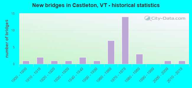
- New bridges - historical statistics
- 11900-1909
- 21910-1919
- 11920-1929
- 11930-1939
- 21940-1949
- 11950-1959
- 71960-1969
- 141970-1979
- 31980-1989
- 12000-2009
- 12010-2019
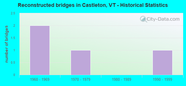
- Reconstructed bridges - Historical Statistics
- 21960-1969
- 11970-1979
- 01980-1989
- 11990-1999
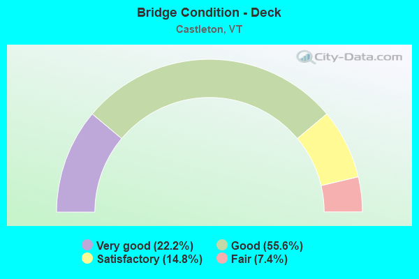
- Bridge Condition - Deck
- 22.2%Very good
- 55.6%Good
- 14.8%Satisfactory
- 7.4%Fair
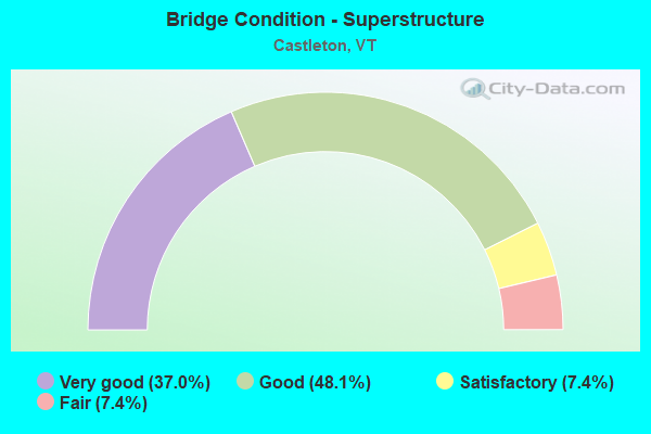
- Bridge Condition - Superstructure
- 37.0%Very good
- 48.1%Good
- 7.4%Satisfactory
- 7.4%Fair

- Bridge Condition - Substructure
- 11.1%Very good
- 48.1%Good
- 37.0%Satisfactory
- 3.7%Fair
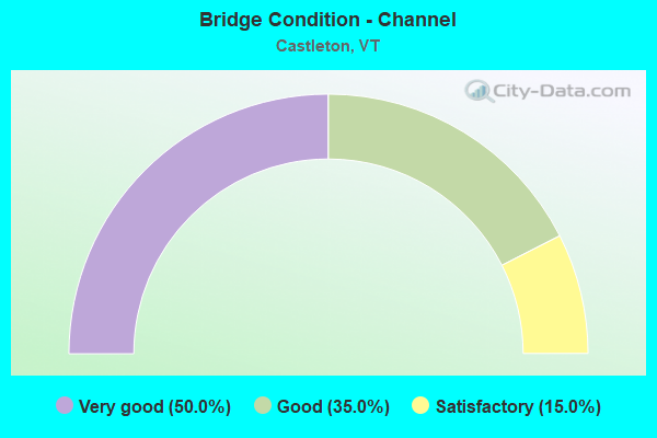
- Bridge Condition - Channel
- 50.0%Very good
- 35.0%Good
- 15.0%Satisfactory
Find on map >> Show street view
Structure Number: 101103000511031, Location: 1.9 MI N VT4A (Lat: 43.638475, Lng: -73.151428), Route carried "on" structure: Other road C2003, Year Built: 1940, Status: Open, Structure Length: 2.07m (6.79ft), Average Daily Traffic: 450 (year 2019), Truck Traffic: 3%, Average Future Daily Traffic: 473 (year 2029), Features Intersected: NORTH BRITTAIN BROOK
Minimum Vertical Clearance: 30+ m (98+ ft), Kilometerpoint: 0.000, Lanes on structure: 2, Owner: Town or Township Highway Agency, Approaching Roadway Width: 7.3m (24.0ft), Skew: 4 degrees, Material/Design: Steel, Design/Construction: Stringer/Multi-beam, Number Of Spans In Main Unit: 1, Length of Maximum Span: 20.1m (65.9ft), Curb or Sidewalk Widths: Left: 0.1m (0.3ft), Right: 0.1m (0.3ft), Curb-To-Curb Width: 6.9m (22.6ft), Out-to-Out Width: 7.6m (24.9ft)
Condition: Deck: Satisfactory, Superstructure: Fair, Substructure: Satisfactory, Channel: Good, Operating Rating: 39.9 metric tons, Method Used To Determine Operating Rating: Allowable Stress (AS), Inventory Rating: 22.7 metric tons, Method Used To Determine Inventory Rating: Allowable Stress (AS), Structural Evaluation: Somewhat better than minimum adequacy, Deck Geometry: Meets minimum limits, Waterway Adequacy: Better than present minimum criteria, Approach Roadway Alignment: Equal to present desirable criteria, Length Of Structure Improvement: 2.07m (6.79ft), Designated Inspection Frequency: Every 24 months, Inspection Date: October 2020, Bridge Improvement Cost: $593,000, Roadway Improvement Cost: $50,000, Total Project Cost: $643,000 ( Estimate for 2020), Deck Structure Type: Concrete Cast-file-Place, Wearing Surface/Protective System: Wearing Surface: Bituminous
Find on map >> Show street view
Structure Number: 101103000711031, Location: 0.6 MI N VT4A (Lat: 43.621775, Lng: -73.161925), Route carried "on" structure: Other road C2003, Year Built: 1919, Year Reconstructed: 1976, Status: Open, Structure Length: 1.49m (4.89ft), Average Daily Traffic: 850 (year 2019), Truck Traffic: 3%, Average Future Daily Traffic: 893 (year 2029), Design Load: HS 20, Features Intersected: NORTH BRITTAIN BROOK
Minimum Vertical Clearance: 30+ m (98+ ft), Kilometerpoint: 0.000, Lanes on structure: 2, Owner: Town or Township Highway Agency, Approaching Roadway Width: 7.9m (25.9ft), Material/Design: Concrete, Design/Construction: Tee Beam, Number Of Spans In Main Unit: 1, Length of Maximum Span: 14.3m (46.9ft), Curb or Sidewalk Widths: Left: 0.2m (0.7ft), Right: 0.2m (0.7ft), Curb-To-Curb Width: 8.6m (28.2ft), Out-to-Out Width: 8.7m (28.5ft)
Condition: Deck: Good, Superstructure: Very good, Substructure: Satisfactory, Channel: Good, Operating Rating: 86.2 metric tons, Method Used To Determine Operating Rating: Allowable Stress (AS), Inventory Rating: 46.3 metric tons, Method Used To Determine Inventory Rating: Allowable Stress (AS), Structural Evaluation: Equal to present minimum criteria, Deck Geometry: Somewhat better than minimum adequacy, Waterway Adequacy: Equal to present desirable criteria, Approach Roadway Alignment: Better than present minimum criteria, Designated Inspection Frequency: Every 24 months, Inspection Date: October 2020, Deck Structure Type: Concrete Cast-file-Place, Wearing Surface/Protective System: Wearing Surface: Bituminous, Membrane: Preformed Fabric
Find on map >> Show street view
Structure Number: 101103000811031, Location: 1.4 MI N VT4A (Lat: 43.633356, Lng: -73.157961), Route carried "on" structure: Other road C2003, Year Built: 1940, Status: Open, Structure Length: 1.68m (5.51ft), Average Daily Traffic: 450 (year 2019), Truck Traffic: 3%, Average Future Daily Traffic: 473 (year 2029), Features Intersected: NORTH BRITTAIN BROOK
Minimum Vertical Clearance: 30+ m (98+ ft), Kilometerpoint: 0.000, Lanes on structure: 2, Owner: Town or Township Highway Agency, Approaching Roadway Width: 6.7m (22.0ft), Skew: 3 degrees, Material/Design: Steel, Design/Construction: Stringer/Multi-beam, Number Of Spans In Main Unit: 1, Length of Maximum Span: 15.8m (51.8ft), Curb or Sidewalk Widths: Left: 0.1m (0.3ft), Right: 0.1m (0.3ft), Curb-To-Curb Width: 6.2m (20.3ft), Out-to-Out Width: 7.0m (23.0ft)
Condition: Deck: Fair, Superstructure: Fair, Substructure: Good, Channel: Satisfactory, Operating Rating: 51.7 metric tons, Method Used To Determine Operating Rating: Allowable Stress (AS), Inventory Rating: 32.7 metric tons, Method Used To Determine Inventory Rating: Allowable Stress (AS), Structural Evaluation: Somewhat better than minimum adequacy, Deck Geometry: High priority of corrective action, Waterway Adequacy: Equal to present minimum criteria, Approach Roadway Alignment: Equal to present desirable criteria, Length Of Structure Improvement: 1.68m (5.51ft), Designated Inspection Frequency: Every 24 months, Inspection Date: October 2020, Bridge Improvement Cost: $443,000, Roadway Improvement Cost: $50,000, Total Project Cost: $493,000 ( Estimate for 2020), Deck Structure Type: Concrete Cast-file-Place, Wearing Surface/Protective System: Wearing Surface: Bituminous
Find on map >> Show street view
Structure Number: 101103003311031, Location: 0.15 MI TO JCT W CL1 TH1 (Lat: 43.611483, Lng: -73.185950), Route carried "on" structure: Other road C3005, Year Built: 1908, Year Reconstructed: 1999, Status: Open, Structure Length: 1.16m (3.81ft), Average Daily Traffic: 40 (year 2019), Truck Traffic: 1%, Average Future Daily Traffic: 42 (year 2029), Design Load: HS 20, Features Intersected: CASTLETON RIVER
Minimum Vertical Clearance: 30+ m (98+ ft), Kilometerpoint: 0.000, Lanes on structure: 1, Owner: Town or Township Highway Agency, Approaching Roadway Width: 4.3m (14.1ft), Material/Design: Steel, Design/Construction: Stringer/Multi-beam, Number Of Spans In Main Unit: 1, Length of Maximum Span: 11.0m (36.1ft), Curb-To-Curb Width: 4.2m (13.8ft), Out-to-Out Width: 4.7m (15.4ft)
Condition: Deck: Good, Superstructure: Very good, Substructure: Good, Channel: Good, Operating Rating: 46.3 metric tons, Method Used To Determine Operating Rating: Allowable Stress (AS), Inventory Rating: 31.8 metric tons, Method Used To Determine Inventory Rating: Allowable Stress (AS), Structural Evaluation: Better than present minimum criteria, Deck Geometry: Somewhat better than minimum adequacy, Waterway Adequacy: Equal to present minimum criteria, Approach Roadway Alignment: Equal to present minimum criteria, Length Of Structure Improvement: 1.16m (3.81ft), Designated Inspection Frequency: Every 24 months, Inspection Date: October 2020, Bridge Improvement Cost: $206,000, Roadway Improvement Cost: $50,000, Total Project Cost: $256,000 ( Estimate for 2020), Deck Structure Type: Wood or Timber, Wearing Surface/Protective System: Wearing Surface: Wood or Timber, Deck Protection: Internally Sealed
Find on map >> Show street view
Structure Number: 101103003411031, Location: 0.25 MI TO JCT W CL1 TH1 (Lat: 43.614125, Lng: -73.181125), Route carried "on" structure: Other road C2005, Year Built: 1968, Status: Open, Structure Length: 2.26m (7.41ft), Average Daily Traffic: 610 (year 2019), Truck Traffic: 2%, Average Future Daily Traffic: 641 (year 2029), Design Load: HS 20, Features Intersected: CASTLETON RIVER
Minimum Vertical Clearance: 30+ m (98+ ft), Kilometerpoint: 0.000, Lanes on structure: 2, Owner: Town or Township Highway Agency, Approaching Roadway Width: 7.9m (25.9ft), Material/Design: Steel, Design/Construction: Stringer/Multi-beam, Number Of Spans In Main Unit: 1, Length of Maximum Span: 21.9m (71.9ft), Curb-To-Curb Width: 9.0m (29.5ft), Out-to-Out Width: 10.1m (33.1ft)
Condition: Deck: Good, Superstructure: Very good, Substructure: Satisfactory, Channel: Satisfactory, Operating Rating: 80.7 metric tons, Method Used To Determine Operating Rating: Allowable Stress (AS), Inventory Rating: 50.8 metric tons, Method Used To Determine Inventory Rating: Allowable Stress (AS), Structural Evaluation: Equal to present minimum criteria, Deck Geometry: Somewhat better than minimum adequacy, Waterway Adequacy: Equal to present desirable criteria, Approach Roadway Alignment: Equal to present desirable criteria, Designated Inspection Frequency: Every 24 months, Inspection Date: October 2020, Deck Structure Type: Concrete Cast-file-Place, Wearing Surface/Protective System: Wearing Surface: Bituminous, Membrane: Preformed Fabric
Find on map >> Show street view
Structure Number: 101103003511031, Location: 0.07 MI TO JCT W CL2 TH3 (Lat: 43.639731, Lng: -73.147569), Route carried "on" structure: Other road C3028, Year Built: 1977, Status: Open, Structure Length: 0.85m (2.79ft), Average Daily Traffic: 100 (year 2019), Truck Traffic: 2%, Average Future Daily Traffic: 105 (year 2029), Design Load: HS 20, Features Intersected: NORTH BRITTAIN BROOK
Minimum Vertical Clearance: 30+ m (98+ ft), Kilometerpoint: 0.000, Lanes on structure: 2, Owner: Town or Township Highway Agency, Approaching Roadway Width: 4.9m (16.1ft), Material/Design: Concrete, Design/Construction: Slab, Number Of Spans In Main Unit: 1, Length of Maximum Span: 7.9m (25.9ft), Curb-To-Curb Width: 4.9m (16.1ft), Out-to-Out Width: 5.0m (16.4ft)
Condition: Deck: Very good, Superstructure: Very good, Substructure: Good, Channel: Good, Operating Rating: 84.4 metric tons, Method Used To Determine Operating Rating: Load Factor (LF), Inventory Rating: 49.9 metric tons, Method Used To Determine Inventory Rating: Load Factor (LF), Structural Evaluation: Better than present minimum criteria, Deck Geometry: High priority of corrective action, Waterway Adequacy: Equal to present desirable criteria, Approach Roadway Alignment: Equal to present desirable criteria, Length Of Structure Improvement: 0.85m (2.79ft), Designated Inspection Frequency: Every 24 months, Inspection Date: October 2020, Bridge Improvement Cost: $162,000, Roadway Improvement Cost: $50,000, Total Project Cost: $212,000 ( Estimate for 2020), Deck Structure Type: Concrete Cast-file-Place, Wearing Surface/Protective System: Wearing Surface: Gravel
Find on map >> Show street view
Structure Number: 101103003611031, Location: 0.1 MI TO JCT W VT4-A (Lat: 43.609197, Lng: -73.124911), Route carried "on" structure: Other road C3048, Year Built: 1977, Status: Open, Structure Length: 0.85m (2.79ft), Average Daily Traffic: 100 (year 2019), Truck Traffic: 2%, Average Future Daily Traffic: 105 (year 2029), Design Load: HS 20, Features Intersected: CASTLETON RIVER
Minimum Vertical Clearance: 30+ m (98+ ft), Kilometerpoint: 0.000, Lanes on structure: 2, Owner: Town or Township Highway Agency, Approaching Roadway Width: 6.1m (20.0ft), Material/Design: Concrete, Design/Construction: Slab, Number Of Spans In Main Unit: 1, Length of Maximum Span: 7.6m (24.9ft), Curb or Sidewalk Widths: Left: 0.1m (0.3ft), Right: 0.1m (0.3ft), Curb-To-Curb Width: 6.1m (20.0ft), Out-to-Out Width: 6.2m (20.3ft)
Condition: Deck: Very good, Superstructure: Very good, Substructure: Good, Channel: Good, Operating Rating: 65.3 metric tons, Method Used To Determine Operating Rating: Allowable Stress (AS), Inventory Rating: 39.9 metric tons, Method Used To Determine Inventory Rating: Allowable Stress (AS), Structural Evaluation: Better than present minimum criteria, Deck Geometry: Somewhat better than minimum adequacy, Waterway Adequacy: Better than present minimum criteria, Approach Roadway Alignment: Equal to present desirable criteria, Designated Inspection Frequency: Every 24 months, Inspection Date: October 2020, Deck Structure Type: Concrete Cast-file-Place, Wearing Surface/Protective System: Wearing Surface: Gravel
Find on map >> Show street view
Structure Number: 101103003711031, Location: 0.4 MI S JCT VT 4A (Lat: 43.600203, Lng: -73.232706), Route carried "on" structure: Other road C2006, Year Built: 1983, Status: Open, Structure Length: 2.29m (7.51ft), Average Daily Traffic: 1,200 (year 2019), Truck Traffic: 2%, Average Future Daily Traffic: 1,260 (year 2029), Design Load: HS 25 or greater, Features Intersected: CASTLETON RIVER
Minimum Vertical Clearance: 30+ m (98+ ft), Kilometerpoint: 0.000, Lanes on structure: 2, Owner: Town or Township Highway Agency, Approaching Roadway Width: 8.5m (27.9ft), Skew: 3 degrees, Material/Design: Steel, Design/Construction: Stringer/Multi-beam, Number Of Spans In Main Unit: 1, Length of Maximum Span: 21.3m (69.9ft), Curb or Sidewalk Widths: Left: 0.2m (0.7ft), Right: 0.2m (0.7ft), Curb-To-Curb Width: 8.1m (26.6ft), Out-to-Out Width: 8.9m (29.2ft)
Condition: Deck: Very good, Superstructure: Very good, Substructure: Very good, Channel: Very good, Operating Rating: 63.5 metric tons, Method Used To Determine Operating Rating: Allowable Stress (AS), Inventory Rating: 40.8 metric tons, Method Used To Determine Inventory Rating: Allowable Stress (AS), Structural Evaluation: Equal to present desirable criteria, Deck Geometry: Meets minimum limits, Waterway Adequacy: Better than present minimum criteria, Approach Roadway Alignment: Equal to present desirable criteria, Designated Inspection Frequency: Every 24 months, Inspection Date: October 2020, Deck Structure Type: Concrete Cast-file-Place, Wearing Surface/Protective System: Wearing Surface: Bituminous, Membrane: Preformed Fabric
Find on map >> Show street view
Structure Number: 101103003811031, Location: 0.25 MI TO JCT W VT30 (Lat: 43.677539, Lng: -73.198239), Route carried "on" structure: Other road C3014, Year Built: 1962, Status: Open, Structure Length: 2.56m (8.40ft), Average Daily Traffic: 200 (year 2019), Truck Traffic: 2%, Average Future Daily Traffic: 210 (year 2029), Design Load: H 20, Features Intersected: LAKE BOMOSEEN
Minimum Vertical Clearance: 30+ m (98+ ft), Kilometerpoint: 0.000, Lanes on structure: 2, Owner: Town or Township Highway Agency, Approaching Roadway Width: 7.6m (24.9ft), Material/Design: Steel, Design/Construction: Stringer/Multi-beam, Number Of Spans In Main Unit: 1, Length of Maximum Span: 25.0m (82.0ft), Curb or Sidewalk Widths: Left: 0.9m (3.0ft), Right: 0.9m (3.0ft), Curb-To-Curb Width: 7.0m (23.0ft), Out-to-Out Width: 8.8m (28.9ft)
Condition: Deck: Good, Superstructure: Good, Substructure: Good, Channel: Very good, Operating Rating: 83.5 metric tons, Method Used To Determine Operating Rating: Load Factor (LF), Inventory Rating: 49.9 metric tons, Method Used To Determine Inventory Rating: Load Factor (LF), Structural Evaluation: Better than present minimum criteria, Deck Geometry: Meets minimum limits, Waterway Adequacy: Better than present minimum criteria, Approach Roadway Alignment: Equal to present desirable criteria, Length Of Structure Improvement: 2.56m (8.40ft), Designated Inspection Frequency: Every 24 months, Inspection Date: October 2020, Bridge Improvement Cost: $853,000, Roadway Improvement Cost: $50,000, Total Project Cost: $903,000 ( Estimate for 2020), Deck Structure Type: Concrete Cast-file-Place, Wearing Surface/Protective System: Wearing Surface: Bituminous, Membrane: Preformed Fabric
Find on map >> Show street view
Structure Number: 200015000513052, Location: 5.4 MI N JCT. U.S.5 (Lat: 42.915247, Lng: -72.612956), Route carried "on" structure: State highway 30, Year Built: 1952, Year Reconstructed: 1972, Status: Open, Structure Length: 2.56m (8.40ft), Average Daily Traffic: 6,300 (year 2018), Truck Traffic: 9%, Average Future Daily Traffic: 6,615 (year 2028), Design Load: H 20, Features Intersected: STICKNEY BROOK
Minimum Vertical Clearance: 30+ m (98+ ft), Kilometerpoint: 8.439, Lanes on structure: 2, Base Highway Network: Yes, Owner: State Highway Agency, Approaching Roadway Width: 9.8m (32.2ft), Material/Design: Steel, Design/Construction: Stringer/Multi-beam, Number Of Spans In Main Unit: 1, Length of Maximum Span: 25.0m (82.0ft), Curb or Sidewalk Widths: Left: 0.5m (1.6ft), Right: 0.5m (1.6ft), Curb-To-Curb Width: 9.5m (31.2ft), Out-to-Out Width: 10.7m (35.1ft)
Condition: Deck: Fair, Superstructure: Good, Substructure: Good, Channel: Good, Operating Rating: 48.1 metric tons, Method Used To Determine Operating Rating: Load Factor (LF), Inventory Rating: 29.0 metric tons, Method Used To Determine Inventory Rating: Load Factor (LF), Structural Evaluation: Better than present minimum criteria, Deck Geometry: High priority of corrective action, Waterway Adequacy: Equal to present minimum criteria, Approach Roadway Alignment: Equal to present desirable criteria, Length Of Structure Improvement: 2.56m (8.40ft), Designated Inspection Frequency: Every 24 months, Inspection Date: May 2021, Bridge Improvement Cost: $1,035,000, Roadway Improvement Cost: $50,000, Total Project Cost: $1,085,000 ( Estimate for 2020), Deck Structure Type: Concrete Cast-file-Place, Wearing Surface/Protective System: Wearing Surface: Bituminous, Membrane: Preformed Fabric
Find on map >> Show street view
Structure Number: 200015009211032, Location: 0.4 MI S JCT. VT.4A (Lat: 43.603597, Lng: -73.209503), Route carried "on" structure: State highway 30, Year Built: 1938, Status: Open, Structure Length: 2.41m (7.91ft), Average Daily Traffic: 6,900 (year 2018), Truck Traffic: 9%, Average Future Daily Traffic: 7,245 (year 2028), Design Load: H 15, Features Intersected: CASTLETON RIVER
Minimum Vertical Clearance: 30+ m (98+ ft), Kilometerpoint: 121.877, Lanes on structure: 2, Base Highway Network: Yes, Owner: State Highway Agency, Approaching Roadway Width: 7.6m (24.9ft), Material/Design: Steel, Design/Construction: Stringer/Multi-beam, Number Of Spans In Main Unit: 1, Length of Maximum Span: 23.5m (77.1ft), Curb or Sidewalk Widths: Left: 0.1m (0.3ft), Right: 0.1m (0.3ft), Curb-To-Curb Width: 7.3m (24.0ft), Out-to-Out Width: 8.1m (26.6ft)
Condition: Deck: Satisfactory, Superstructure: Good, Substructure: Good, Channel: Good, Operating Rating: 50.8 metric tons, Method Used To Determine Operating Rating: Load Factor (LF), Inventory Rating: 29.9 metric tons, Method Used To Determine Inventory Rating: Load Factor (LF), Structural Evaluation: Better than present minimum criteria, Deck Geometry: High priority of replacement, Waterway Adequacy: Somewhat better than minimum adequacy, Approach Roadway Alignment: Equal to present desirable criteria, Length Of Structure Improvement: 2.41m (7.91ft), Designated Inspection Frequency: Every 24 months, Inspection Date: May 2021, Bridge Improvement Cost: $738,000, Roadway Improvement Cost: $50,000, Total Project Cost: $788,000 ( Estimate for 2020), Deck Structure Type: Concrete Cast-file-Place, Wearing Surface/Protective System: Wearing Surface: Bituminous, Membrane: Preformed Fabric
Find on map >> Show street view
Structure Number: 200015009311032, Location: 0.3 MI S JCT. VT.4A (Lat: 43.604408, Lng: -73.209347), Route carried "on" structure: State highway 30, Year Built: 2015, Status: Open, Structure Length: 2.13m (6.99ft), Average Daily Traffic: 6,900 (year 2018), Truck Traffic: 6%, Average Future Daily Traffic: 7,245 (year 2028), Design Load: HL 93, Features Intersected: CLARENDON PITTSFORD R.R.
Minimum Vertical Clearance: 30+ m (98+ ft), Kilometerpoint: 121.957, Lanes on structure: 2, Base Highway Network: Yes, Owner: State Highway Agency, Approaching Roadway Width: 9.8m (32.2ft), Material/Design: Prestressed concrete, Design/Construction: Tee Beam, Number Of Spans In Main Unit: 1, Length of Maximum Span: 20.4m (66.9ft), Curb or Sidewalk Widths: Left: 0.2m (0.7ft), Right: 0.2m (0.7ft), Curb-To-Curb Width: 9.8m (32.2ft), Out-to-Out Width: 10.7m (35.1ft)
Condition: Deck: Very good, Superstructure: Very good, Substructure: Very good, Operating Rating: 47.2 metric tons, Method Used To Determine Operating Rating: Load and Resistance Factor (LRFR), Inventory Rating: 35.4 metric tons, Method Used To Determine Inventory Rating: Load and Resistance Factor (LRFR), Structural Evaluation: Equal to present desirable criteria, Deck Geometry: Meets minimum limits, Underclear: Somewhat better than minimum adequacy, Approach Roadway Alignment: Equal to present desirable criteria, Designated Inspection Frequency: Every 24 months, Inspection Date: May 2021, Deck Structure Type: Concrete Precast Panels, Wearing Surface/Protective System: Wearing Surface: Bituminous, Membrane: Preformed Fabric, Deck Protection: Other Coated Reinforcing
Find on map >> Show street view
Structure Number: 200020008E11032, Location: 1.4 MI W EXIT 4 VT.30 (Lat: 43.611361, Lng: -73.231611), Route carried "on" structure: US 4, Year Built: 1971, Status: Open, Structure Length: 16.55m (54.30ft), Average Daily Traffic: 9,800 (year 2018), Truck Traffic: 10%, Average Future Daily Traffic: 10,290 (year 2028), Design Load: HS 20, Features Intersected: LAKE BOMOSEEN TH 2
Minimum Vertical Clearance: 30+ m (98+ ft), Kilometerpoint: 12.294, Lanes on structure: 2, Lanes under structure: 2, Base Highway Network: Yes, Owner: State Highway Agency, Approaching Roadway Width: 11.9m (39.0ft), Material/Design: Steel continuous, Design/Construction: Stringer/Multi-beam, Number Of Spans In Main Unit: 3, Length of Maximum Span: 79.2m (259.8ft), Curb or Sidewalk Widths: Left: 0.2m (0.7ft), Right: 0.2m (0.7ft), Curb-To-Curb Width: 11.2m (36.7ft), Out-to-Out Width: 12.5m (41.0ft)
Condition: Deck: Good, Superstructure: Good, Substructure: Satisfactory, Channel: Very good, Operating Rating: 89.8 metric tons, Method Used To Determine Operating Rating: Load Factor (LF), Inventory Rating: 89.8 metric tons, Method Used To Determine Inventory Rating: Load Factor (LF), Structural Evaluation: Equal to present minimum criteria, Deck Geometry: Meets minimum limits, Underclear: Better than present minimum criteria, Waterway Adequacy: Equal to present desirable criteria, Approach Roadway Alignment: Equal to present desirable criteria, Designated Inspection Frequency: Every 24 months, Inspection Date: May 2021, Deck Structure Type: Concrete Cast-file-Place, Wearing Surface/Protective System: Wearing Surface: Bituminous, Membrane: Preformed Fabric
Find on map >> Show street view
Structure Number: 200020008W11032, Location: 1.4 MI W EXIT 4 VT.30 (Lat: 43.611669, Lng: -73.231589), Route carried "on" structure: US 4, Year Built: 1971, Status: Open, Structure Length: 16.55m (54.30ft), Average Daily Traffic: 9,800 (year 2018), Truck Traffic: 10%, Average Future Daily Traffic: 10,290 (year 2028), Design Load: HS 20, Features Intersected: LAKE BOMOSEEN TH 2
Minimum Vertical Clearance: 30+ m (98+ ft), Kilometerpoint: 12.294, Lanes on structure: 2, Lanes under structure: 2, Base Highway Network: Yes, Owner: State Highway Agency, Approaching Roadway Width: 11.9m (39.0ft), Material/Design: Steel continuous, Design/Construction: Stringer/Multi-beam, Number Of Spans In Main Unit: 3, Length of Maximum Span: 79.2m (259.8ft), Curb or Sidewalk Widths: Left: 0.2m (0.7ft), Right: 0.2m (0.7ft), Curb-To-Curb Width: 11.2m (36.7ft), Out-to-Out Width: 12.5m (41.0ft)
Condition: Deck: Good, Superstructure: Satisfactory, Substructure: Satisfactory, Channel: Very good, Operating Rating: 89.8 metric tons, Method Used To Determine Operating Rating: Load Factor (LF), Inventory Rating: 89.8 metric tons, Method Used To Determine Inventory Rating: Load Factor (LF), Structural Evaluation: Equal to present minimum criteria, Deck Geometry: Meets minimum limits, Underclear: Superior to present desirable criteria, Waterway Adequacy: Equal to present desirable criteria, Approach Roadway Alignment: Equal to present desirable criteria, Designated Inspection Frequency: Every 24 months, Inspection Date: May 2021, Deck Structure Type: Concrete Cast-file-Place, Wearing Surface/Protective System: Wearing Surface: Bituminous, Membrane: Preformed Fabric
Find on map >> Show street view
Structure Number: 200020010E11032, Location: US 4 EXIT 4 VT 30 (Lat: 43.616250, Lng: -73.206617), Route carried "on" structure: US 4, Year Built: 1971, Status: Open, Structure Length: 7.10m (23.29ft), Average Daily Traffic: 9,800 (year 2018), Truck Traffic: 10%, Average Future Daily Traffic: 10,290 (year 2028), Design Load: HS 20, Features Intersected: US 4 OVER VT 30
Minimum Vertical Clearance: 30+ m (98+ ft), Kilometerpoint: 14.386, Lanes on structure: 2, Lanes under structure: 2, Base Highway Network: Yes, Owner: State Highway Agency, Approaching Roadway Width: 11.6m (38.1ft), Skew: 3 degrees, Material/Design: Steel, Design/Construction: Stringer/Multi-beam, Number Of Spans In Main Unit: 1, Number Of Approach Spans: 2, Length of Maximum Span: 45.7m (149.9ft), Curb or Sidewalk Widths: Left: 0.2m (0.7ft), Right: 0.2m (0.7ft), Curb-To-Curb Width: 11.2m (36.7ft), Out-to-Out Width: 12.5m (41.0ft)
Condition: Deck: Good, Superstructure: Good, Substructure: Satisfactory, Operating Rating: 89.8 metric tons, Method Used To Determine Operating Rating: Load Factor (LF), Inventory Rating: 61.7 metric tons, Method Used To Determine Inventory Rating: Load Factor (LF), Structural Evaluation: Equal to present minimum criteria, Deck Geometry: Meets minimum limits, Underclear: Somewhat better than minimum adequacy, Approach Roadway Alignment: Equal to present desirable criteria, Designated Inspection Frequency: Every 24 months, Inspection Date: May 2021, Deck Structure Type: Concrete Cast-file-Place, Wearing Surface/Protective System: Wearing Surface: Bituminous, Membrane: Preformed Fabric
Find on map >> Show street view
Structure Number: 200020010W11032, Location: US 4 EXIT 4 VT 30 (Lat: 43.617192, Lng: -73.206483), Route carried "on" structure: US 4, Year Built: 1971, Status: Open, Structure Length: 7.10m (23.29ft), Average Daily Traffic: 9,800 (year 2018), Truck Traffic: 10%, Average Future Daily Traffic: 10,290 (year 2028), Design Load: HS 20, Features Intersected: US 4 OVER VT 30
Minimum Vertical Clearance: 30+ m (98+ ft), Kilometerpoint: 14.386, Lanes on structure: 2, Lanes under structure: 2, Base Highway Network: Yes, Owner: State Highway Agency, Approaching Roadway Width: 11.6m (38.1ft), Skew: 3 degrees, Material/Design: Steel, Design/Construction: Stringer/Multi-beam, Number Of Spans In Main Unit: 1, Number Of Approach Spans: 2, Length of Maximum Span: 45.7m (149.9ft), Curb or Sidewalk Widths: Left: 0.2m (0.7ft), Right: 0.2m (0.7ft), Curb-To-Curb Width: 11.2m (36.7ft), Out-to-Out Width: 12.5m (41.0ft)
Condition: Deck: Good, Superstructure: Good, Substructure: Fair, Operating Rating: 89.8 metric tons, Method Used To Determine Operating Rating: Load Factor (LF), Inventory Rating: 61.7 metric tons, Method Used To Determine Inventory Rating: Load Factor (LF), Structural Evaluation: Somewhat better than minimum adequacy, Deck Geometry: Meets minimum limits, Underclear: Meets minimum limits, Approach Roadway Alignment: Equal to present desirable criteria, Length Of Structure Improvement: 7.10m (23.29ft), Designated Inspection Frequency: Every 24 months, Inspection Date: May 2021, Bridge Improvement Cost: $3,344,000, Roadway Improvement Cost: $50,000, Total Project Cost: $3,394,000 ( Estimate for 2020), Deck Structure Type: Concrete Cast-file-Place, Wearing Surface/Protective System: Wearing Surface: Bituminous, Membrane: Preformed Fabric
Find on map >> Show street view
Structure Number: 200142000111072, Location: 0.1 MI E JCT VT.22A S (Lat: 43.590108, Lng: -73.265106), Route carried "on" structure: Alternate State highway 4A, Year Built: 1924, Year Reconstructed: 1969, Status: Open, Structure Length: 1.62m (5.31ft), Average Daily Traffic: 5,400 (year 2018), Truck Traffic: 6%, Average Future Daily Traffic: 5,670 (year 2028), Design Load: H 15, Features Intersected: CASTLETON RIVER
Minimum Vertical Clearance: 30+ m (98+ ft), Kilometerpoint: 0.000, Lanes on structure: 2, Owner: Town or Township Highway Agency, Approaching Roadway Width: 8.8m (28.9ft), Material/Design: Concrete, Design/Construction: Tee Beam, Number Of Spans In Main Unit: 1, Length of Maximum Span: 15.5m (50.9ft), Curb or Sidewalk Widths: Left: 0.5m (1.6ft), Right: 2.1m (6.9ft), Curb-To-Curb Width: 9.1m (29.9ft), Out-to-Out Width: 12.3m (40.4ft)
Condition: Deck: Satisfactory, Superstructure: Satisfactory, Substructure: Satisfactory, Channel: Very good, Operating Rating: 39.0 metric tons, Method Used To Determine Operating Rating: Load Factor (LF), Inventory Rating: 23.6 metric tons, Method Used To Determine Inventory Rating: Load Factor (LF), Structural Evaluation: Somewhat better than minimum adequacy, Deck Geometry: High priority of corrective action, Waterway Adequacy: Equal to present minimum criteria, Approach Roadway Alignment: Equal to present minimum criteria, Length Of Structure Improvement: 1.62m (5.31ft), Designated Inspection Frequency: Every 24 months, Inspection Date: June 2021, Bridge Improvement Cost: $748,000, Roadway Improvement Cost: $50,000, Total Project Cost: $798,000 ( Estimate for 2020), Deck Structure Type: Concrete Cast-file-Place, Wearing Surface/Protective System: Wearing Surface: Bituminous
Find on map >> Show street view
Structure Number: 200142000411032, Location: 0.4 MI E JCT. VT.30 (Lat: 43.607444, Lng: -73.200153), Route carried "on" structure: Alternate State highway 4A, Year Built: 1962, Status: Open, Structure Length: 3.90m (12.80ft), Average Daily Traffic: 4,600 (year 2018), Truck Traffic: 6%, Average Future Daily Traffic: 4,830 (year 2028), Design Load: HS 20, Features Intersected: CASTLETON RIVER
Minimum Vertical Clearance: 30+ m (98+ ft), Kilometerpoint: 0.000, Lanes on structure: 2, Owner: State Highway Agency, Approaching Roadway Width: 12.2m (40.0ft), Material/Design: Steel continuous, Design/Construction: Stringer/Multi-beam, Number Of Spans In Main Unit: 2, Length of Maximum Span: 18.9m (62.0ft), Curb or Sidewalk Widths: Left: 0.5m (1.6ft), Right: 0.5m (1.6ft), Curb-To-Curb Width: 9.1m (29.9ft), Out-to-Out Width: 10.7m (35.1ft)
Condition: Deck: Satisfactory, Superstructure: Good, Substructure: Good, Channel: Very good, Operating Rating: 60.8 metric tons, Method Used To Determine Operating Rating: Allowable Stress (AS), Inventory Rating: 39.9 metric tons, Method Used To Determine Inventory Rating: Allowable Stress (AS), Structural Evaluation: Better than present minimum criteria, Deck Geometry: Meets minimum limits, Waterway Adequacy: Somewhat better than minimum adequacy, Approach Roadway Alignment: Equal to present desirable criteria, Length Of Structure Improvement: 3.90m (12.80ft), Designated Inspection Frequency: Every 24 months, Inspection Date: June 2021, Bridge Improvement Cost: $1,568,000, Roadway Improvement Cost: $50,000, Total Project Cost: $1,618,000 ( Estimate for 2020), Deck Structure Type: Concrete Cast-file-Place, Wearing Surface/Protective System: Wearing Surface: Bituminous, Membrane: Preformed Fabric
Find on map >> Show street view
Structure Number: 200142000711032, Location: 2.0 MI E JCT. VT.30 (Lat: 43.613608, Lng: -73.168817), Route carried "on" structure: Alternate State highway 4A, Year Built: 1964, Status: Open, Structure Length: 2.10m (6.89ft), Average Daily Traffic: 3,300 (year 2018), Truck Traffic: 6%, Average Future Daily Traffic: 3,465 (year 2028), Design Load: HS 20, Features Intersected: CASTLETON RIVER
Minimum Vertical Clearance: 30+ m (98+ ft), Kilometerpoint: 0.000, Lanes on structure: 2, Owner: State Highway Agency, Approaching Roadway Width: 11.9m (39.0ft), Material/Design: Steel, Design/Construction: Stringer/Multi-beam, Number Of Spans In Main Unit: 1, Length of Maximum Span: 20.4m (66.9ft), Curb or Sidewalk Widths: Left: 0.5m (1.6ft), Right: 0.5m (1.6ft), Curb-To-Curb Width: 9.2m (30.2ft), Out-to-Out Width: 10.8m (35.4ft)
Condition: Deck: Good, Superstructure: Good, Substructure: Good, Channel: Very good, Operating Rating: 86.2 metric tons, Method Used To Determine Operating Rating: Load Factor (LF), Inventory Rating: 51.7 metric tons, Method Used To Determine Inventory Rating: Load Factor (LF), Structural Evaluation: Better than present minimum criteria, Deck Geometry: Meets minimum limits, Waterway Adequacy: Somewhat better than minimum adequacy, Approach Roadway Alignment: Equal to present desirable criteria, Length Of Structure Improvement: 2.10m (6.89ft), Designated Inspection Frequency: Every 24 months, Inspection Date: June 2021, Bridge Improvement Cost: $852,000, Roadway Improvement Cost: $50,000, Total Project Cost: $903,000 ( Estimate for 2020), Deck Structure Type: Concrete Cast-file-Place, Wearing Surface/Protective System: Wearing Surface: Bituminous, Membrane: Preformed Fabric
Find on map >> Show street view
Structure Number: 200142000811032, Location: 2.4 MI E JCT. VT.30 (Lat: 43.613950, Lng: -73.162164), Route carried "on" structure: Alternate State highway 4A, Year Built: 2007, Status: Open, Structure Length: 1.83m (6.00ft), Average Daily Traffic: 1,900 (year 2018), Truck Traffic: 3%, Average Future Daily Traffic: 1,995 (year 2028), Design Load: HS 25 or greater, Features Intersected: CASTLETON RIVER
Minimum Vertical Clearance: 30+ m (98+ ft), Kilometerpoint: 0.000, Lanes on structure: 2, Owner: State Highway Agency, Approaching Roadway Width: 8.5m (27.9ft), Skew: 2 degrees, Material/Design: Prestressed concrete, Design/Construction: Slab, Number Of Spans In Main Unit: 1, Length of Maximum Span: 17.4m (57.1ft), Curb or Sidewalk Widths: Left: 0.2m (0.7ft), Right: 0.2m (0.7ft), Curb-To-Curb Width: 8.2m (26.9ft), Out-to-Out Width: 9.4m (30.8ft)
Condition: Deck: Very good, Superstructure: Very good, Substructure: Very good, Channel: Very good, Operating Rating: 51.7 metric tons, Method Used To Determine Operating Rating: Load Factor (LF), Inventory Rating: 47.2 metric tons, Method Used To Determine Inventory Rating: Load Factor (LF), Structural Evaluation: Equal to present desirable criteria, Deck Geometry: Meets minimum limits, Waterway Adequacy: Equal to present minimum criteria, Approach Roadway Alignment: Equal to present desirable criteria, Designated Inspection Frequency: Every 24 months, Inspection Date: June 2021, Deck Structure Type: Concrete Precast Panels, Wearing Surface/Protective System: Wearing Surface: Bituminous, Membrane: Preformed Fabric, Deck Protection: Epoxy Coated Reinforcing
Find on map >> Show street view
Structure Number: 200142001111032, Location: 3.9 MI E JCT. VT.30 (Lat: 43.613692, Lng: -73.133817), Route carried "on" structure: Alternate State highway 4A, Year Built: 1988, Status: Open, Structure Length: 1.89m (6.20ft), Average Daily Traffic: 1,900 (year 2018), Truck Traffic: 6%, Average Future Daily Traffic: 1,995 (year 2028), Design Load: HS 25 or greater, Features Intersected: CASTLETON RIVER
Minimum Vertical Clearance: 30+ m (98+ ft), Kilometerpoint: 0.000, Lanes on structure: 2, Owner: State Highway Agency, Approaching Roadway Width: 12.2m (40.0ft), Skew: 3 degrees, Material/Design: Steel, Design/Construction: Stringer/Multi-beam, Number Of Spans In Main Unit: 1, Length of Maximum Span: 18.3m (60.0ft), Curb or Sidewalk Widths: Left: 0.2m (0.7ft), Right: 0.2m (0.7ft), Curb-To-Curb Width: 10.1m (33.1ft), Out-to-Out Width: 11.1m (36.4ft)
Condition: Deck: Very good, Superstructure: Very good, Substructure: Good, Channel: Very good, Operating Rating: 74.4 metric tons, Method Used To Determine Operating Rating: Allowable Stress (AS), Inventory Rating: 42.6 metric tons, Method Used To Determine Inventory Rating: Allowable Stress (AS), Structural Evaluation: Better than present minimum criteria, Deck Geometry: Somewhat better than minimum adequacy, Waterway Adequacy: Equal to present desirable criteria, Approach Roadway Alignment: Equal to present desirable criteria, Designated Inspection Frequency: Every 24 months, Inspection Date: June 2021, Deck Structure Type: Concrete Cast-file-Place, Wearing Surface/Protective System: Wearing Surface: Bituminous, Membrane: Preformed Fabric, Deck Protection: Epoxy Coated Reinforcing
Find on map >> Show street view
Structure Number: 200142001211032, Location: 5.0 MI E JCT. VT.30 (Lat: 43.609636, Lng: -73.112817), Route carried "on" structure: Alternate State highway 4A, Year Built: 1989, Status: Open, Structure Length: 1.40m (4.59ft), Average Daily Traffic: 1,900 (year 2018), Truck Traffic: 6%, Average Future Daily Traffic: 1,995 (year 2028), Design Load: HS 25 or greater, Features Intersected: CASTLETON RIVER
Minimum Vertical Clearance: 30+ m (98+ ft), Kilometerpoint: 0.000, Lanes on structure: 2, Owner: State Highway Agency, Approaching Roadway Width: 10.4m (34.1ft), Material/Design: Concrete, Design/Construction: Slab, Number Of Spans In Main Unit: 1, Length of Maximum Span: 13.4m (44.0ft), Curb or Sidewalk Widths: Left: 0.2m (0.7ft), Right: 0.2m (0.7ft), Curb-To-Curb Width: 9.9m (32.5ft), Out-to-Out Width: 11.2m (36.7ft)
Condition: Deck: Good, Superstructure: Good, Substructure: Good, Channel: Very good, Operating Rating: 89.8 metric tons, Method Used To Determine Operating Rating: Load Factor (LF), Inventory Rating: 62.6 metric tons, Method Used To Determine Inventory Rating: Load Factor (LF), Structural Evaluation: Better than present minimum criteria, Deck Geometry: Somewhat better than minimum adequacy, Waterway Adequacy: Equal to present desirable criteria, Approach Roadway Alignment: Equal to present desirable criteria, Designated Inspection Frequency: Every 24 months, Inspection Date: June 2021, Deck Structure Type: Concrete Cast-file-Place, Wearing Surface/Protective System: Wearing Surface: Bituminous, Membrane: Preformed Fabric, Deck Protection: Epoxy Coated Reinforcing
Find on map >> Show street view
Structure Number: 2011030D1111031, Location: 6.9 MI E EXIT 4 (Lat: 43.619539, Lng: -73.181933), Route carried "on" structure: County highway TH5, Year Built: 1971, Status: Open, Structure Length: 12.31m (40.39ft), Average Daily Traffic: 600 (year 2019), Truck Traffic: 2%, Average Future Daily Traffic: 630 (year 2029), Design Load: HS 20+Mod, Features Intersected: TH NO 5 OVER US 4
Minimum Vertical Clearance: 30+ m (98+ ft), Kilometerpoint: 0.000, Lanes on structure: 2, Lanes under structure: 4, Owner: State Highway Agency, Approaching Roadway Width: 7.6m (24.9ft), Skew: 3 degrees, Material/Design: Steel continuous, Design/Construction: Frame, Number Of Spans In Main Unit: 5, Length of Maximum Span: 33.8m (110.9ft), Curb or Sidewalk Widths: Left: 0.2m (0.7ft), Right: 0.2m (0.7ft), Curb-To-Curb Width: 8.2m (26.9ft), Out-to-Out Width: 9.4m (30.8ft)
Condition: Deck: Good, Superstructure: Good, Substructure: Satisfactory, Operating Rating: 58.1 metric tons, Method Used To Determine Operating Rating: Allowable Stress (AS), Inventory Rating: 32.7 metric tons, Method Used To Determine Inventory Rating: Allowable Stress (AS), Structural Evaluation: Equal to present minimum criteria, Deck Geometry: Somewhat better than minimum adequacy, Underclear: Better than present minimum criteria, Approach Roadway Alignment: Equal to present desirable criteria, Designated Inspection Frequency: Every 24 months, Inspection Date: May 2021, Deck Structure Type: Concrete Cast-file-Place, Wearing Surface/Protective System: Wearing Surface: Bituminous, Membrane: Preformed Fabric
Find on map >> Show street view
Structure Number: 2011030D9E11031, Location: 0.5 MI W EXIT 4 (Lat: 43.614072, Lng: -73.215242), Route carried "on" structure: County highway TH24, Year Built: 1971, Status: Open, Structure Length: 3.75m (12.30ft), Average Daily Traffic: 400 (year 2019), Truck Traffic: 2%, Average Future Daily Traffic: 420 (year 2029), Design Load: HS 20+Mod, Features Intersected: TH NO 24 OVER US 4
Minimum Vertical Clearance: 30+ m (98+ ft), Kilometerpoint: 0.000, Lanes on structure: 2, Lanes under structure: 2, Owner: State Highway Agency, Approaching Roadway Width: 8.5m (27.9ft), Material/Design: Steel, Design/Construction: Stringer/Multi-beam, Number Of Spans In Main Unit: 1, Length of Maximum Span: 36.6m (120.1ft), Curb or Sidewalk Widths: Left: 0.2m (0.7ft), Right: 0.2m (0.7ft), Curb-To-Curb Width: 8.2m (26.9ft), Out-to-Out Width: 9.4m (30.8ft)
Condition: Deck: Good, Superstructure: Good, Substructure: Satisfactory, Operating Rating: 89.8 metric tons, Method Used To Determine Operating Rating: Load Factor (LF), Inventory Rating: 60.8 metric tons, Method Used To Determine Inventory Rating: Load Factor (LF), Structural Evaluation: Equal to present minimum criteria, Deck Geometry: Somewhat better than minimum adequacy, Underclear: Better than present minimum criteria, Approach Roadway Alignment: Equal to present desirable criteria, Designated Inspection Frequency: Every 24 months, Inspection Date: May 2021, Deck Structure Type: Concrete Cast-file-Place, Wearing Surface/Protective System: Wearing Surface: Bituminous, Membrane: Preformed Fabric
Find on map >> Show street view
Structure Number: 2011030D9W11031, Location: 0.5 MI W EXIT 4 (Lat: 43.614928, Lng: -73.215561), Route carried "on" structure: County highway TH24, Year Built: 1971, Status: Open, Structure Length: 3.75m (12.30ft), Average Daily Traffic: 375 (year 2019), Truck Traffic: 2%, Average Future Daily Traffic: 394 (year 2029), Design Load: HS 20+Mod, Features Intersected: TH NO 24 OVER US 4
Minimum Vertical Clearance: 30+ m (98+ ft), Kilometerpoint: 0.000, Lanes on structure: 2, Lanes under structure: 2, Owner: State Highway Agency, Approaching Roadway Width: 8.5m (27.9ft), Material/Design: Steel, Design/Construction: Stringer/Multi-beam, Number Of Spans In Main Unit: 1, Length of Maximum Span: 36.6m (120.1ft), Curb or Sidewalk Widths: Left: 0.2m (0.7ft), Right: 0.2m (0.7ft), Curb-To-Curb Width: 8.2m (26.9ft), Out-to-Out Width: 9.4m (30.8ft)
Condition: Deck: Good, Superstructure: Very good, Substructure: Satisfactory, Operating Rating: 89.8 metric tons, Method Used To Determine Operating Rating: Load Factor (LF), Inventory Rating: 60.8 metric tons, Method Used To Determine Inventory Rating: Load Factor (LF), Structural Evaluation: Equal to present minimum criteria, Deck Geometry: Somewhat better than minimum adequacy, Underclear: Better than present minimum criteria, Approach Roadway Alignment: Equal to present desirable criteria, Designated Inspection Frequency: Every 24 months, Inspection Date: May 2021, Deck Structure Type: Concrete Cast-file-Place, Wearing Surface/Protective System: Wearing Surface: Bituminous
Find on map >> Show street view
Structure Number: 203142000111032, Location: 0.1 MI N JCT. VT.4A (Lat: 43.614983, Lng: -73.165836), Route carried "on" structure: Spur State highway 915, Year Built: 1964, Status: Open, Structure Length: 2.10m (6.89ft), Average Daily Traffic: 2,300 (year 2018), Truck Traffic: 6%, Average Future Daily Traffic: 2,415 (year 2028), Design Load: HS 20, Features Intersected: BRITTAIN BROOK
Minimum Vertical Clearance: 30+ m (98+ ft), Kilometerpoint: 0.000, Lanes on structure: 2, Owner: State Highway Agency, Approaching Roadway Width: 10.1m (33.1ft), Skew: 1 degrees, Material/Design: Steel, Design/Construction: Stringer/Multi-beam, Number Of Spans In Main Unit: 1, Length of Maximum Span: 20.4m (66.9ft), Curb-To-Curb Width: 9.1m (29.9ft), Out-to-Out Width: 10.7m (35.1ft)
Condition: Deck: Good, Superstructure: Good, Substructure: Good, Channel: Satisfactory, Operating Rating: 88.9 metric tons, Method Used To Determine Operating Rating: Load Factor (LF), Inventory Rating: 53.5 metric tons, Method Used To Determine Inventory Rating: Load Factor (LF), Structural Evaluation: Better than present minimum criteria, Deck Geometry: Meets minimum limits, Waterway Adequacy: Better than present minimum criteria, Approach Roadway Alignment: Equal to present desirable criteria, Designated Inspection Frequency: Every 24 months, Inspection Date: June 2021, Deck Structure Type: Concrete Cast-file-Place, Wearing Surface/Protective System: Wearing Surface: Bituminous, Membrane: Preformed Fabric
Find on map >> Show street view
Structure Number: 203142000211032, Location: 0.2 MI N JCT. VT.4A (Lat: 43.616772, Lng: -73.165717), Route carried "on" structure: Spur State highway 915, Year Built: 1968, Status: Open, Structure Length: 7.99m (26.21ft), Average Daily Traffic: 1,700 (year 2018), Truck Traffic: 6%, Average Future Daily Traffic: 1,785 (year 2028), Design Load: HS 20, Features Intersected: VT915 CONN. OVER US 4
Minimum Vertical Clearance: 30+ m (98+ ft), Kilometerpoint: 0.000, Lanes on structure: 2, Lanes under structure: 4, Owner: State Highway Agency, Approaching Roadway Width: 10.1m (33.1ft), Skew: 2 degrees, Material/Design: Steel, Design/Construction: Stringer/Multi-beam, Number Of Spans In Main Unit: 4, Length of Maximum Span: 26.5m (86.9ft), Curb or Sidewalk Widths: Left: 0.2m (0.7ft), Right: 0.2m (0.7ft), Curb-To-Curb Width: 9.2m (30.2ft), Out-to-Out Width: 10.9m (35.8ft)
Condition: Deck: Good, Superstructure: Good, Substructure: Good, Operating Rating: 66.2 metric tons, Method Used To Determine Operating Rating: Load Factor (LF), Inventory Rating: 39.9 metric tons, Method Used To Determine Inventory Rating: Load Factor (LF), Structural Evaluation: Better than present minimum criteria, Deck Geometry: Somewhat better than minimum adequacy, Underclear: Better than present minimum criteria, Approach Roadway Alignment: Equal to present desirable criteria, Designated Inspection Frequency: Every 24 months, Inspection Date: May 2021, Deck Structure Type: Concrete Cast-file-Place, Wearing Surface/Protective System: Wearing Surface: Bituminous, Membrane: Preformed Fabric
Find on map >> Show street view
Structure Number: 101103003211031, Location: 0.15 MI TO JCT W C3 TH43 (Lat: 43.591697, Lng: -73.197589), Route carried "under" structure: Other road C2004, Year Built: 1915, Structure Length: 0. m, Average Daily Traffic: 500 (year 1996), Truck Traffic: 2%, Features Intersected: CLASS 2, TH4, Facility Carried by Structure: PEDESTRIAN TRAIL
Kilometerpoint: 0.000, Material/Design: Steel, Design/Construction: Girder and Floorbeam System, Length of Maximum Span: 9.4m (30.8ft)
Find on map >> Show street view
Structure Number: 200020010E11032, Location: US 4 EXIT 4 VT 30 (Lat: 43.616250, Lng: -73.206617), Route carried "under" structure: State highway 30, Year Built: 1971, Structure Length: 0. m, Average Daily Traffic: 5,900 (year 1998), Truck Traffic: 9%, Features Intersected: US 4 OVER VT 30, Facility Carried by Structure: US 00004 ML
Minimum Vertical Clearance: 4.52m (14.83ft), Kilometerpoint: 123.309, Lanes on structure: 2, Material/Design: Steel, Design/Construction: Stringer/Multi-beam, Length of Maximum Span: 45.7m (149.9ft)
Find on map >> Show street view
Structure Number: 200020010W11032, Location: US 4 EXIT 4 VT 30 (Lat: 43.617192, Lng: -73.206483), Route carried "under" structure: State highway 30, Year Built: 1971, Structure Length: 0. m, Average Daily Traffic: 4,200 (year 1998), Truck Traffic: 9%, Features Intersected: US 4 OVER VT 30, Facility Carried by Structure: US 00004 ML
Minimum Vertical Clearance: 4.39m (14.40ft), Kilometerpoint: 123.309, Lanes on structure: 2, Material/Design: Steel, Design/Construction: Stringer/Multi-beam, Length of Maximum Span: 45.7m (149.9ft)
Find on map >> Show street view
Structure Number: 2011030D1111031, Location: 6.9 MI E EXIT 4 (Lat: 43.619539, Lng: -73.181933), Route carried "under" structure: US 4, Year Built: 1971, Structure Length: 0. m, Average Daily Traffic: 7,800 (year 1998), Truck Traffic: 10%, Features Intersected: US 4 UNDER TH NO 5, Facility Carried by Structure: TR 00TH5
Minimum Vertical Clearance: 5.68m (18.64ft), Kilometerpoint: 16.719, Lanes on structure: 2, Material/Design: Steel continuous, Design/Construction: Frame, Length of Maximum Span: 33.8m (110.9ft)
Find on map >> Show street view
Structure Number: 2011030D9E11031, Location: 0.5 MI W EXIT 4 (Lat: 43.614072, Lng: -73.215242), Route carried "under" structure: US 4, Year Built: 1971, Structure Length: 0. m, Average Daily Traffic: 4,250 (year 1998), Truck Traffic: 10%, Features Intersected: US 4 UNDER TH NO 24
Minimum Vertical Clearance: 4.82m (15.81ft), Kilometerpoint: 13.646, Lanes on structure: 2, Material/Design: Steel, Design/Construction: Stringer/Multi-beam, Length of Maximum Span: 36.6m (120.1ft)
Find on map >> Show street view
Structure Number: 2011030D9W11031, Location: 0.5 MI W EXIT 4 (Lat: 43.614928, Lng: -73.215561), Route carried "under" structure: US 4, Year Built: 1971, Structure Length: 0. m, Average Daily Traffic: 4,250 (year 1998), Truck Traffic: 10%, Features Intersected: US 4 UNDER TH NO 24
Minimum Vertical Clearance: 5.07m (16.63ft), Kilometerpoint: 13.646, Lanes on structure: 2, Material/Design: Steel, Design/Construction: Stringer/Multi-beam, Length of Maximum Span: 36.6m (120.1ft)
Find on map >> Show street view
Structure Number: 203142000211032, Location: 0.2 MI N JCT. VT.4A (Lat: 43.616772, Lng: -73.165717), Route carried "under" structure: US 4, Year Built: 1968, Structure Length: 0. m, Average Daily Traffic: 13,300 (year 1998), Truck Traffic: 10%, Features Intersected: US 4 UNDER CSTLN SH, Facility Carried by Structure: VT 00915 SPUR
Minimum Vertical Clearance: 5.66m (18.57ft), Kilometerpoint: 18.103, Lanes on structure: 2, Material/Design: Steel, Design/Construction: Stringer/Multi-beam, Length of Maximum Span: 26.5m (86.9ft)