Bridge Statistics for Centerville, Utah (UT)
Condition, Traffic, Stress, Structural Evaluation, Project Costs
- National Bridge Inventory (NBI) Statistics
- 13Number of bridges
- 121ft / 37.2mTotal length
- 534,622Total average daily traffic
- 104,774Total average daily truck traffic
- National Bridge Inventory (NBI) Registered Bridges for Centerville
- No street view available for this location
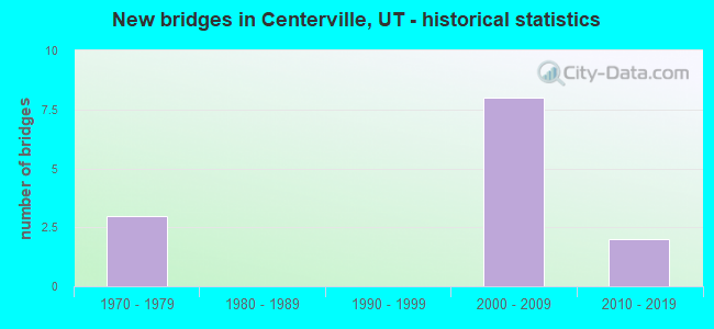
- New bridges - historical statistics
- 31970-1979
- 82000-2009
- 22010-2019
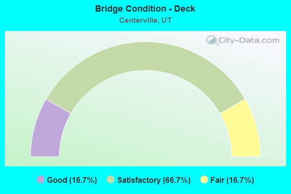
- Bridge Condition - Deck
- 16.7%Good
- 66.7%Satisfactory
- 16.7%Fair
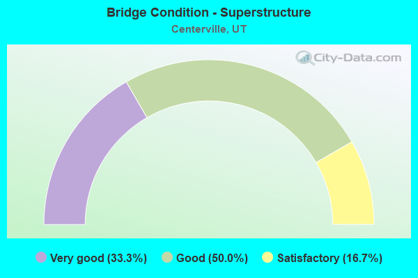
- Bridge Condition - Superstructure
- 33.3%Very good
- 50.0%Good
- 16.7%Satisfactory
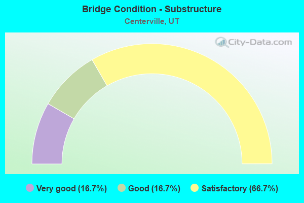
- Bridge Condition - Substructure
- 16.7%Very good
- 16.7%Good
- 66.7%Satisfactory
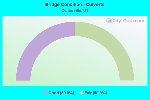
- Bridge Condition - Culverts
- 50.0%Good
- 50.0%Fair
Find on map >> Show street view
Structure Number: C 578, Location: W.of PARRISH LN.INT.-CNVL (Lat: 40.921522, Lng: -111.892342), Route carried "on" structure: State highway 105, Year Built: 1970, Year Reconstructed: 2008, Status: Open, Structure Length: 3.99m (13.09ft), Average Daily Traffic: 5,560 (year 2020), Truck Traffic: 12%, Average Future Daily Traffic: 6,950 (year 2040), Design Load: HS 20+Mod, Features Intersected: UPRR and UTA TRACKS
Minimum Vertical Clearance: 30+ m (98+ ft), Kilometerpoint: 0.681, Lanes on structure: 5, Owner: State Highway Agency, Approaching Roadway Width: 23.4m (76.8ft), Material/Design: Steel continuous, Design/Construction: Stringer/Multi-beam, Number Of Spans In Main Unit: 3, Length of Maximum Span: 16.2m (53.1ft), Curb-To-Curb Width: 23.4m (76.8ft), Out-to-Out Width: 24.4m (80.1ft)
Condition: Deck: Satisfactory, Superstructure: Satisfactory, Substructure: Satisfactory, Operating Rating: 34.3 metric tons, Method Used To Determine Operating Rating: Load and Resistance Factor Rating (LRFR) rating reported by rating factor(RF) method using HL-93 loadings, Inventory Rating: 30.1 metric tons, Method Used To Determine Inventory Rating: Load Factor (LF) rating reported by rating factor (RF) method using MS18 loading, Structural Evaluation: Equal to present minimum criteria, Deck Geometry: Better than present minimum criteria, Underclear: Somewhat better than minimum adequacy, Approach Roadway Alignment: Better than present minimum criteria, Designated Inspection Frequency: Every 24 months, Inspection Date: June 2021, Deck Structure Type: Concrete Cast-file-Place, Wearing Surface/Protective System: Wearing Surface: Bituminous, Membrane: Preformed Fabric, Deck Protection: Epoxy Coated Reinforcing
Find on map >> Show street view
Structure Number: C 596, Location: PARRISH LN.INT.-CNTRVIL. (Lat: 40.921522, Lng: -111.891478), Route carried "on" structure: State highway 105, Year Built: 1974, Year Reconstructed: 2007, Status: Open, Structure Length: 7.41m (24.31ft), Average Daily Traffic: 5,560 (year 2020), Truck Traffic: 12%, Average Future Daily Traffic: 6,950 (year 2040), Design Load: HS 20+Mod, Features Intersected: I-15 (SR-15) NBL AND SBL
Minimum Vertical Clearance: 30+ m (98+ ft), Kilometerpoint: 0.754, Lanes on structure: 5, Lanes under structure: 8, Owner: State Highway Agency, Approaching Roadway Width: 21.9m (71.9ft), Material/Design: Steel continuous, Design/Construction: Stringer/Multi-beam, Number Of Spans In Main Unit: 2, Length of Maximum Span: 38.3m (125.7ft), Curb-To-Curb Width: 21.9m (71.9ft), Out-to-Out Width: 22.8m (74.8ft)
Condition: Deck: Satisfactory, Superstructure: Good, Substructure: Satisfactory, Operating Rating: 38.2 metric tons, Method Used To Determine Operating Rating: Load and Resistance Factor Rating (LRFR) rating reported by rating factor(RF) method using HL-93 loadings, Inventory Rating: 28.8 metric tons, Method Used To Determine Inventory Rating: Load Factor (LF) rating reported by rating factor (RF) method using MS18 loading, Structural Evaluation: Equal to present minimum criteria, Deck Geometry: Somewhat better than minimum adequacy, Underclear: Equal to present minimum criteria, Approach Roadway Alignment: Equal to present minimum criteria, Designated Inspection Frequency: Every 24 months, Inspection Date: June 2021, Deck Structure Type: Concrete Cast-file-Place, Wearing Surface/Protective System: Wearing Surface: Bituminous, Membrane: Preformed Fabric
Find on map >> Show street view
Structure Number: C1029, Location: Parrish Ln. Trail (Lat: 40.921653, Lng: -111.890822), Route carried "on" structure: 15, Year Built: 2015, Structure Length: 7.44m (24.41ft), Average Daily Traffic: 137,164 (year 2020), Truck Traffic: 20%, Average Future Daily Traffic: 171,455 (year 2040), Design Load: Pedestrian, Features Intersected: I-15, Facility Carried by Structure: Parrish Ln Ped
Minimum Vertical Clearance: 30+ m (98+ ft), Kilometerpoint: 514.728, Lanes under structure: 10, Owner: State Highway Agency, Approaching Roadway Width: 3.0m (9.8ft), Material/Design: Steel, Design/Construction: Stringer/Multi-beam, Number Of Spans In Main Unit: 2, Length of Maximum Span: 38.4m (126.0ft), Curb-To-Curb Width: 3.0m (9.8ft), Out-to-Out Width: 3.7m (12.1ft)
Condition: Deck: Good, Superstructure: Very good, Substructure: Very good, Underclear: High priority of corrective action, Approach Roadway Alignment: Superior to present desirable criteria, Designated Inspection Frequency: Every 24 months, Inspection Date: June 2021, Deck Structure Type: Concrete Cast-file-Place, Wearing Surface/Protective System: Deck Protection: Epoxy Coated Reinforcing
Find on map >> Show street view
Structure Number: E2554, Location: 1000 No.1250W.Centerville (Lat: 40.929167, Lng: -111.896944), Route carried "on" structure: State highway 67, Year Built: 2008, Status: Open, Structure Length: 1.02m (3.35ft), Average Daily Traffic: 22,775 (year 2020), Truck Traffic: 23%, Average Future Daily Traffic: 28,469 (year 2040), Design Load: HL 93, Features Intersected: 1000NO.DRAINAGE CHANNEL
Minimum Vertical Clearance: 30+ m (98+ ft), Kilometerpoint: 12.704, Lanes on structure: 6, Owner: State Highway Agency, Approaching Roadway Width: 30.9m (101.4ft), Skew: 14 degrees, Material/Design: Concrete, Design/Construction: Culvert, Number Of Spans In Main Unit: 2, Length of Maximum Span: 4.6m (15.1ft)
Condition: Channel: Good, Culverts: Good, Operating Rating: 32.4 metric tons, Method Used To Determine Operating Rating: Load and Resistance Factor Rating (LRFR) rating reported by rating factor(RF) method using HL-93 loadings, Inventory Rating: 32.4 metric tons, Method Used To Determine Inventory Rating: Load and Resistance Factor Rating (LRFR) rating reported by rating factor(RF) method using HL-93 loadings, Structural Evaluation: Better than present minimum criteria, Waterway Adequacy: Equal to present minimum criteria, Approach Roadway Alignment: Better than present minimum criteria, Designated Inspection Frequency: Every 24 months, Underwater Inspection Frequency: Every 60 months, Inspection Date: June 2021, Underwater Inspection Date: July 2019
Find on map >> Show street view
Structure Number: E2573, Location: 2500 No. 850W. W. Bntfl. (Lat: 40.918072, Lng: -111.901769), Route carried "on" structure: State highway 67, Year Built: 2008, Status: Open, Structure Length: 1.94m (6.36ft), Average Daily Traffic: 20,610 (year 2020), Truck Traffic: 21%, Average Future Daily Traffic: 25,763 (year 2040), Design Load: HL 93, Features Intersected: LEGACY PARKWAY TRAIL
Minimum Vertical Clearance: 30+ m (98+ ft), Kilometerpoint: 11.492, Lanes on structure: 4, Owner: State Highway Agency, Approaching Roadway Width: 20.0m (65.6ft), Skew: 26 degrees, Material/Design: Concrete, Design/Construction: Culvert, Number Of Spans In Main Unit: 1, Length of Maximum Span: 17.8m (58.4ft)
Condition: Culverts: Fair, Operating Rating: 57.7 metric tons, Method Used To Determine Operating Rating: Load and Resistance Factor Rating (LRFR) rating reported by rating factor(RF) method using HL-93 loadings, Inventory Rating: 48.0 metric tons, Method Used To Determine Inventory Rating: Load and Resistance Factor Rating (LRFR) rating reported by rating factor(RF) method using HL-93 loadings, Structural Evaluation: Somewhat better than minimum adequacy, Approach Roadway Alignment: Better than present minimum criteria, Designated Inspection Frequency: Every 24 months, Inspection Date: June 2021, Wearing Surface/Protective System: Wearing Surface: Bituminous
Find on map >> Show street view
Structure Number: F 719, Location: 1100No.1250W.Centerville (Lat: 40.930381, Lng: -111.894906), Route carried "on" structure: City street 1431, Year Built: 2008, Status: Open, Structure Length: 8.50m (27.89ft), Average Daily Traffic: 909 (year 2020), Average Future Daily Traffic: 1,136 (year 2040), Design Load: HL 93, Features Intersected: SR-67,LEGACY PARKWAY, Facility Carried by Structure: 1250 WEST STREET
Minimum Vertical Clearance: 30+ m (98+ ft), Kilometerpoint: 2.711, Lanes on structure: 2, Lanes under structure: 4, Owner: State Highway Agency, Approaching Roadway Width: 12.2m (40.0ft), Skew: 5 degrees, Material/Design: Prestressed concrete continuous, Design/Construction: Stringer/Multi-beam, Number Of Spans In Main Unit: 2, Length of Maximum Span: 41.1m (134.8ft), Curb or Sidewalk Widths: Left: 3.0m (9.8ft), Right: 0.0m, Curb-To-Curb Width: 12.2m (40.0ft), Out-to-Out Width: 16.5m (54.1ft)
Condition: Deck: Fair, Superstructure: Very good, Substructure: Satisfactory, Operating Rating: 40.5 metric tons, Method Used To Determine Operating Rating: Load and Resistance Factor Rating (LRFR) rating reported by rating factor(RF) method using HL-93 loadings, Inventory Rating: 24.6 metric tons, Method Used To Determine Inventory Rating: Load and Resistance Factor Rating (LRFR) rating reported by rating factor(RF) method using HL-93 loadings, Structural Evaluation: Equal to present minimum criteria, Deck Geometry: Equal to present desirable criteria, Underclear: Meets minimum limits, Approach Roadway Alignment: Somewhat better than minimum adequacy, Designated Inspection Frequency: Every 24 months, Inspection Date: June 2021, Deck Structure Type: Concrete Cast-file-Place, Wearing Surface/Protective System: Wearing Surface: Integral Concrete, Deck Protection: Epoxy Coated Reinforcing
Find on map >> Show street view
Structure Number: 1F 667, Location: 1400 W.400 N.,Centerville (Lat: 40.921236, Lng: -111.899869), Route carried "on" structure: State highway 67, Year Built: 2008, Status: Open, Structure Length: 3.45m (11.32ft), Average Daily Traffic: 22,775 (year 2020), Truck Traffic: 23%, Average Future Daily Traffic: 28,469 (year 2040), Design Load: HL 93, Features Intersected: SR-105, PARRISH LANE
Minimum Vertical Clearance: 30+ m (98+ ft), Kilometerpoint: 11.883, Lanes on structure: 2, Lanes under structure: 2, Owner: State Highway Agency, Approaching Roadway Width: 18.3m (60.0ft), Skew: 10 degrees, Material/Design: Prestressed concrete, Design/Construction: Stringer/Multi-beam, Number Of Spans In Main Unit: 1, Length of Maximum Span: 33.5m (109.9ft), Curb-To-Curb Width: 18.3m (60.0ft), Out-to-Out Width: 19.4m (63.6ft)
Condition: Deck: Satisfactory, Superstructure: Good, Substructure: Good, Operating Rating: 41.5 metric tons, Method Used To Determine Operating Rating: Load and Resistance Factor Rating (LRFR) rating reported by rating factor(RF) method using HL-93 loadings, Inventory Rating: 39.9 metric tons, Method Used To Determine Inventory Rating: Load and Resistance Factor Rating (LRFR) rating reported by rating factor(RF) method using HL-93 loadings, Structural Evaluation: Better than present minimum criteria, Deck Geometry: Superior to present desirable criteria, Underclear: Meets minimum limits, Approach Roadway Alignment: Equal to present minimum criteria, Designated Inspection Frequency: Every 24 months, Inspection Date: June 2021, Deck Structure Type: Concrete Cast-file-Place, Wearing Surface/Protective System: Wearing Surface: Epoxy Overlay, Deck Protection: Epoxy Coated Reinforcing
Find on map >> Show street view
Structure Number: 3F 667, Location: 1400 W.400 No.Centerville (Lat: 40.921831, Lng: -111.900053), Route carried "on" structure: State highway 67, Year Built: 2008, Status: Open, Structure Length: 3.45m (11.32ft), Average Daily Traffic: 20,610 (year 2020), Truck Traffic: 21%, Average Future Daily Traffic: 25,763 (year 2040), Design Load: HL 93, Features Intersected: SR105, PARRISH LANE
Minimum Vertical Clearance: 30+ m (98+ ft), Kilometerpoint: 11.567, Lanes on structure: 2, Lanes under structure: 2, Owner: State Highway Agency, Approaching Roadway Width: 18.3m (60.0ft), Skew: 10 degrees, Material/Design: Prestressed concrete, Design/Construction: Stringer/Multi-beam, Number Of Spans In Main Unit: 1, Length of Maximum Span: 33.5m (109.9ft), Curb-To-Curb Width: 18.3m (60.0ft), Out-to-Out Width: 19.4m (63.6ft)
Condition: Deck: Satisfactory, Superstructure: Good, Substructure: Satisfactory, Operating Rating: 41.1 metric tons, Method Used To Determine Operating Rating: Load and Resistance Factor Rating (LRFR) rating reported by rating factor(RF) method using HL-93 loadings, Inventory Rating: 39.5 metric tons, Method Used To Determine Inventory Rating: Load and Resistance Factor Rating (LRFR) rating reported by rating factor(RF) method using HL-93 loadings, Structural Evaluation: Equal to present minimum criteria, Deck Geometry: Superior to present desirable criteria, Underclear: Meets minimum limits, Approach Roadway Alignment: Equal to present desirable criteria, Designated Inspection Frequency: Every 24 months, Inspection Date: June 2021, Deck Structure Type: Concrete Cast-file-Place, Wearing Surface/Protective System: Wearing Surface: Integral Concrete, Deck Protection: Epoxy Coated Reinforcing
Find on map >> Show street view
Structure Number: C 596, Location: PARRISH LN.INT.-CNTRVIL. (Lat: 40.921522, Lng: -111.891478), Route carried "under" structure: Interstate 15, Year Built: 1974, Structure Length: 0. m, Average Daily Traffic: 132,382 (year 2020), Truck Traffic: 19%, Features Intersected: I-15 (SR-15) NBL AND SBL, Facility Carried by Structure: SR-105,-INT.X-RD.
Minimum Vertical Clearance: 5.15m (16.90ft), Kilometerpoint: 514.203, Lanes on structure: 5, Lanes under structure: 8, Material/Design: Steel continuous, Design/Construction: Stringer/Multi-beam, Length of Maximum Span: 38.3m (125.7ft)
Find on map >> Show street view
Structure Number: C1029, Location: Parrish Ln. Trail (Lat: 40.921653, Lng: -111.890822), Route carried "under" structure: Interstate 15, Year Built: 2015, Structure Length: 0. m, Average Daily Traffic: 132,382 (year 2020), Truck Traffic: 19%, Features Intersected: I-15, Facility Carried by Structure: Parrish Ln Ped
Minimum Vertical Clearance: 6.37m (20.90ft), Kilometerpoint: 514.234, Lanes under structure: 10, Material/Design: Steel, Design/Construction: Stringer/Multi-beam, Length of Maximum Span: 38.4m (126.0ft)
Find on map >> Show street view
Structure Number: F 719, Location: 1100No.1250W.Centerville (Lat: 40.930381, Lng: -111.894906), Route carried "under" structure: State highway 67, Year Built: 2008, Structure Length: 0. m, Average Daily Traffic: 22,775 (year 2020), Truck Traffic: 23%, Features Intersected: SR-67,LEGACY PARKWAY, Facility Carried by Structure: 1250 WEST STREET
Minimum Vertical Clearance: 5.21m (17.09ft), Kilometerpoint: 12.938, Lanes on structure: 2, Lanes under structure: 4, Material/Design: Prestressed concrete continuous, Design/Construction: Stringer/Multi-beam, Length of Maximum Span: 41.1m (134.8ft)
Find on map >> Show street view
Structure Number: 1F 667, Location: 1400 W.400 N.,Centerville (Lat: 40.921236, Lng: -111.899869), Route carried "under" structure: State highway 105, Year Built: 2008, Structure Length: 0. m, Average Daily Traffic: 5,560 (year 2020), Truck Traffic: 12%, Features Intersected: SR-105, PARRISH LANE, Facility Carried by Structure: SR67NB,LEGACY PKWY
Minimum Vertical Clearance: 5.26m (17.26ft), Kilometerpoint: 0.048, Lanes on structure: 2, Lanes under structure: 2, Material/Design: Prestressed concrete, Design/Construction: Stringer/Multi-beam, Length of Maximum Span: 33.5m (109.9ft)
Find on map >> Show street view
Structure Number: 3F 667, Location: 1400 W.400 No.Centerville (Lat: 40.921831, Lng: -111.900053), Route carried "under" structure: State highway 105, Year Built: 2008, Structure Length: 0. m, Average Daily Traffic: 5,560 (year 2020), Truck Traffic: 12%, Features Intersected: SR105, PARRISH LANE, Facility Carried by Structure: SR67SB,LEGACY PKWY
Minimum Vertical Clearance: 5.21m (17.09ft), Kilometerpoint: 0.029, Lanes on structure: 2, Lanes under structure: 2, Material/Design: Prestressed concrete, Design/Construction: Stringer/Multi-beam, Length of Maximum Span: 33.5m (109.9ft)