Bridge Statistics for Central, Alaska (AK)
Condition, Traffic, Stress, Structural Evaluation, Project Costs
- National Bridge Inventory (NBI) Statistics
- 10Number of bridges
- 59ft / 18.3mTotal length
- 1,100Total average daily traffic
- 135Total average daily truck traffic
- 1,720Total future (year 2039) average daily traffic
- National Bridge Inventory (NBI) Registered Bridges for Central
- No street view available for this location
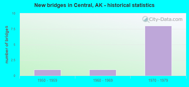
- New bridges - historical statistics
- 11950-1959
- 11960-1969
- 81970-1979
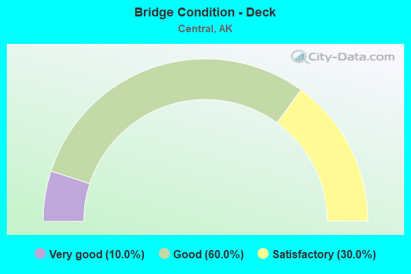
- Bridge Condition - Deck
- 10.0%Very good
- 60.0%Good
- 30.0%Satisfactory
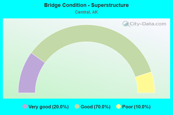
- Bridge Condition - Superstructure
- 20.0%Very good
- 70.0%Good
- 10.0%Poor
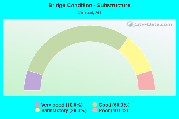
- Bridge Condition - Substructure
- 10.0%Very good
- 60.0%Good
- 20.0%Satisfactory
- 10.0%Poor
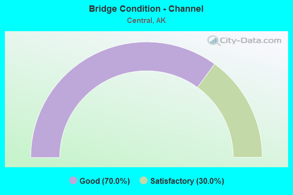
- Bridge Condition - Channel
- 70.0%Good
- 30.0%Satisfactory
Find on map >> Show street view
Structure Number: 275, Location: MILE POINT 80.1 (Lat: 65.400186, Lng: -145.740269), Route carried "on" structure: State highway 670, Year Built: 1961, Status: Open, Structure Length: 3.75m (12.30ft), Average Daily Traffic: 100 (year 2020), Truck Traffic: 13%, Average Future Daily Traffic: 140 (year 2039), Design Load: HS 20, Features Intersected: NORTH FORK 12 MILE CREEK, Facility Carried by Structure: STEESE HIGHWAY
Minimum Vertical Clearance: 4.24m (13.91ft), Kilometerpoint: 143.466, Lanes on structure: 2, Base Highway Network: Yes, Owner: State Highway Agency, Approaching Roadway Width: 9.4m (30.8ft), Material/Design: Steel, Design/Construction: Stringer/Multi-beam, Number Of Spans In Main Unit: 3, Length of Maximum Span: 15.2m (49.9ft), Curb-To-Curb Width: 8.5m (27.9ft), Out-to-Out Width: 9.8m (32.2ft)
Condition: Deck: Good, Superstructure: Very good, Substructure: Satisfactory, Channel: Satisfactory, Operating Rating: 69.2 metric tons, Method Used To Determine Operating Rating: Load Factor (LF), Inventory Rating: 31.8 metric tons, Method Used To Determine Inventory Rating: Load Factor (LF), Structural Evaluation: Equal to present minimum criteria, Deck Geometry: Better than present minimum criteria, Waterway Adequacy: Equal to present minimum criteria, Approach Roadway Alignment: Equal to present desirable criteria, Designated Inspection Frequency: Every 24 months, Inspection Date: August 2020, Deck Structure Type: Concrete Cast-file-Place, Wearing Surface/Protective System: Wearing Surface: Monolithic Concrete
Find on map >> Show street view
Structure Number: 431, Location: MILE POINT 122.3 (Lat: 65.572361, Lng: -144.801139), Route carried "on" structure: State highway 670, Year Built: 1957, Status: Open, Structure Length: 2.47m (8.10ft), Average Daily Traffic: 110 (year 2020), Truck Traffic: 13%, Average Future Daily Traffic: 150 (year 2039), Design Load: H 15, Features Intersected: CROOKED CREEK, Facility Carried by Structure: IRR:STEESE HIGHWAY
Minimum Vertical Clearance: 4.24m (13.91ft), Kilometerpoint: 196.829, Lanes on structure: 1, Owner: State Highway Agency, Approaching Roadway Width: 7.3m (24.0ft), Material/Design: Steel, Design/Construction: Truss - Thru, Number Of Spans In Main Unit: 1, Length of Maximum Span: 24.1m (79.1ft), Curb-To-Curb Width: 4.3m (14.1ft), Out-to-Out Width: 4.9m (16.1ft)
Condition: Deck: Satisfactory, Superstructure: Poor, Substructure: Poor, Channel: Satisfactory, Operating Rating: 37.1 metric tons, Method Used To Determine Operating Rating: Load Factor (LF), Inventory Rating: 27.1 metric tons, Method Used To Determine Inventory Rating: Load Factor (LF), Structural Evaluation: Meets minimum limits, Deck Geometry: High priority of replacement, Waterway Adequacy: High priority of corrective action, Approach Roadway Alignment: Somewhat better than minimum adequacy, Designated Inspection Frequency: Every 24 months, Critical Feature Inspection Frequency: Every 24 months, Inspection Date: August 2020, Critical Feature Inspection Date: August 2021, Deck Structure Type: Wood or Timber, Wearing Surface/Protective System: Wearing Surface: Wood or Timber
Find on map >> Show street view
Structure Number: 819, Location: MILE POINT 38.8 (Lat: 65.539233, Lng: -144.764522), Route carried "on" structure: State highway 670, Year Built: 1975, Status: Open, Structure Length: 0.85m (2.79ft), Average Daily Traffic: 120 (year 2020), Truck Traffic: 10%, Average Future Daily Traffic: 210 (year 2039), Design Load: HS 20+Mod, Features Intersected: DEADWOOD CREEK, Facility Carried by Structure: CIRCLE HOT SPRINGS
Minimum Vertical Clearance: 30+ m (98+ ft), Kilometerpoint: 62.381, Lanes on structure: 2, Owner: State Highway Agency, Approaching Roadway Width: 7.3m (24.0ft), Material/Design: Wood or Timber, Design/Construction: Stringer/Multi-beam, Number Of Spans In Main Unit: 1, Length of Maximum Span: 7.6m (24.9ft), Curb-To-Curb Width: 7.2m (23.6ft), Out-to-Out Width: 7.8m (25.6ft)
Condition: Deck: Very good, Superstructure: Good, Substructure: Satisfactory, Channel: Good, Operating Rating: 67.9 metric tons, Method Used To Determine Operating Rating: Load Factor (LF), Inventory Rating: 40.6 metric tons, Method Used To Determine Inventory Rating: Load Factor (LF), Structural Evaluation: Equal to present minimum criteria, Deck Geometry: Meets minimum limits, Waterway Adequacy: Equal to present desirable criteria, Approach Roadway Alignment: Equal to present desirable criteria, Designated Inspection Frequency: Every 24 months, Inspection Date: August 2020, Deck Structure Type: Wood or Timber, Wearing Surface/Protective System: Wearing Surface: Bituminous
Find on map >> Show street view
Structure Number: 826, Location: MILE POINT 84.7 (Lat: 65.411103, Lng: -145.887378), Route carried "on" structure: State highway 670, Year Built: 1971, Status: Open, Structure Length: 1.73m (5.68ft), Average Daily Traffic: 100 (year 2020), Truck Traffic: 13%, Average Future Daily Traffic: 140 (year 2039), Design Load: HS 20+Mod, Features Intersected: REED CREEK, Facility Carried by Structure: STEESE HIGHWAY
Minimum Vertical Clearance: 4.24m (13.91ft), Kilometerpoint: 136.381, Lanes on structure: 2, Base Highway Network: Yes, Owner: State Highway Agency, Approaching Roadway Width: 9.1m (29.9ft), Skew: 2 degrees, Material/Design: Steel, Design/Construction: Stringer/Multi-beam, Number Of Spans In Main Unit: 1, Length of Maximum Span: 16.8m (55.1ft), Curb-To-Curb Width: 8.5m (27.9ft), Out-to-Out Width: 8.8m (28.9ft)
Condition: Deck: Satisfactory, Superstructure: Good, Substructure: Good, Channel: Good, Operating Rating: 65.8 metric tons, Method Used To Determine Operating Rating: Load Factor (LF), Inventory Rating: 30.4 metric tons, Method Used To Determine Inventory Rating: Load Factor (LF), Structural Evaluation: Better than present minimum criteria, Deck Geometry: Better than present minimum criteria, Waterway Adequacy: Equal to present minimum criteria, Approach Roadway Alignment: Equal to present desirable criteria, Designated Inspection Frequency: Every 24 months, Inspection Date: August 2020, Deck Structure Type: Concrete Cast-file-Place, Wearing Surface/Protective System: Wearing Surface: Monolithic Concrete
Find on map >> Show street view
Structure Number: 827, Location: MILE POINT 91.4 (Lat: 65.405847, Lng: -145.679953), Route carried "on" structure: State highway 670, Year Built: 1971, Status: Open, Structure Length: 1.72m (5.64ft), Average Daily Traffic: 100 (year 2020), Truck Traffic: 13%, Average Future Daily Traffic: 140 (year 2039), Design Load: HS 20+Mod, Features Intersected: WILLOW CREEK, Facility Carried by Structure: STEESE HIGHWAY
Minimum Vertical Clearance: 4.24m (13.91ft), Kilometerpoint: 147.075, Lanes on structure: 2, Base Highway Network: Yes, Owner: State Highway Agency, Approaching Roadway Width: 11.9m (39.0ft), Skew: 1 degrees, Material/Design: Steel, Design/Construction: Stringer/Multi-beam, Number Of Spans In Main Unit: 1, Length of Maximum Span: 16.8m (55.1ft), Curb-To-Curb Width: 8.5m (27.9ft), Out-to-Out Width: 8.8m (28.9ft)
Condition: Deck: Satisfactory, Superstructure: Very good, Substructure: Good, Channel: Good, Operating Rating: 65.8 metric tons, Method Used To Determine Operating Rating: Load Factor (LF), Inventory Rating: 30.4 metric tons, Method Used To Determine Inventory Rating: Load Factor (LF), Structural Evaluation: Better than present minimum criteria, Deck Geometry: Better than present minimum criteria, Waterway Adequacy: Equal to present desirable criteria, Approach Roadway Alignment: Equal to present desirable criteria, Designated Inspection Frequency: Every 24 months, Inspection Date: August 2020, Deck Structure Type: Concrete Cast-file-Place, Wearing Surface/Protective System: Wearing Surface: Monolithic Concrete
Find on map >> Show street view
Structure Number: 828, Location: MILE POINT 93.1 (Lat: 65.409864, Lng: -145.622958), Route carried "on" structure: State highway 670, Year Built: 1971, Status: Open, Structure Length: 1.43m (4.69ft), Average Daily Traffic: 100 (year 2020), Truck Traffic: 13%, Average Future Daily Traffic: 140 (year 2039), Design Load: HS 20+Mod, Features Intersected: BEAR CREEK, Facility Carried by Structure: STEESE HIGHWAY
Minimum Vertical Clearance: 4.24m (13.91ft), Kilometerpoint: 149.901, Lanes on structure: 2, Base Highway Network: Yes, Owner: State Highway Agency, Approaching Roadway Width: 9.4m (30.8ft), Material/Design: Steel, Design/Construction: Stringer/Multi-beam, Number Of Spans In Main Unit: 1, Length of Maximum Span: 13.7m (44.9ft), Curb-To-Curb Width: 8.5m (27.9ft), Out-to-Out Width: 8.8m (28.9ft)
Condition: Deck: Good, Superstructure: Good, Substructure: Good, Channel: Good, Operating Rating: 65.8 metric tons, Method Used To Determine Operating Rating: Load Factor (LF), Inventory Rating: 30.4 metric tons, Method Used To Determine Inventory Rating: Load Factor (LF), Structural Evaluation: Better than present minimum criteria, Deck Geometry: Better than present minimum criteria, Waterway Adequacy: Equal to present desirable criteria, Approach Roadway Alignment: Equal to present desirable criteria, Designated Inspection Frequency: Every 24 months, Inspection Date: August 2020, Deck Structure Type: Concrete Cast-file-Place, Wearing Surface/Protective System: Wearing Surface: Monolithic Concrete
Find on map >> Show street view
Structure Number: 829, Location: MILE POINT 95.2 (Lat: 65.425503, Lng: -145.566961), Route carried "on" structure: State highway 670, Year Built: 1971, Status: Open, Structure Length: 1.73m (5.68ft), Average Daily Traffic: 100 (year 2020), Truck Traffic: 13%, Average Future Daily Traffic: 140 (year 2039), Design Load: HS 20+Mod, Features Intersected: FISH CREEK, Facility Carried by Structure: STEESE HIGHWAY
Minimum Vertical Clearance: 4.24m (13.91ft), Kilometerpoint: 153.173, Lanes on structure: 2, Base Highway Network: Yes, Owner: State Highway Agency, Approaching Roadway Width: 9.8m (32.2ft), Skew: 2 degrees, Material/Design: Steel, Design/Construction: Stringer/Multi-beam, Number Of Spans In Main Unit: 1, Length of Maximum Span: 16.8m (55.1ft), Curb-To-Curb Width: 8.5m (27.9ft), Out-to-Out Width: 8.8m (28.9ft)
Condition: Deck: Good, Superstructure: Good, Substructure: Good, Channel: Good, Operating Rating: 65.8 metric tons, Method Used To Determine Operating Rating: Load Factor (LF), Inventory Rating: 30.4 metric tons, Method Used To Determine Inventory Rating: Load Factor (LF), Structural Evaluation: Better than present minimum criteria, Deck Geometry: Better than present minimum criteria, Waterway Adequacy: Equal to present desirable criteria, Approach Roadway Alignment: Equal to present desirable criteria, Designated Inspection Frequency: Every 24 months, Inspection Date: August 2020, Deck Structure Type: Concrete Cast-file-Place, Wearing Surface/Protective System: Wearing Surface: Monolithic Concrete
Find on map >> Show street view
Structure Number: 832, Location: MILE POINT 120.8 (Lat: 65.571186, Lng: -144.884414), Route carried "on" structure: State highway 670, Year Built: 1971, Status: Open, Structure Length: 1.57m (5.15ft), Average Daily Traffic: 140 (year 2020), Truck Traffic: 13%, Average Future Daily Traffic: 300 (year 2039), Design Load: HS 20+Mod, Features Intersected: BOULDER CREEK, Facility Carried by Structure: STEESE HIGHWAY
Minimum Vertical Clearance: 4.24m (13.91ft), Kilometerpoint: 194.415, Lanes on structure: 2, Base Highway Network: Yes, Owner: State Highway Agency, Approaching Roadway Width: 8.2m (26.9ft), Material/Design: Steel, Design/Construction: Stringer/Multi-beam, Number Of Spans In Main Unit: 1, Length of Maximum Span: 15.2m (49.9ft), Curb-To-Curb Width: 8.5m (27.9ft), Out-to-Out Width: 8.8m (28.9ft)
Condition: Deck: Good, Superstructure: Good, Substructure: Good, Channel: Good, Operating Rating: 66.6 metric tons, Method Used To Determine Operating Rating: Load Factor (LF), Inventory Rating: 30.7 metric tons, Method Used To Determine Inventory Rating: Load Factor (LF), Structural Evaluation: Better than present minimum criteria, Deck Geometry: Equal to present minimum criteria, Waterway Adequacy: Equal to present desirable criteria, Approach Roadway Alignment: Equal to present desirable criteria, Designated Inspection Frequency: Every 24 months, Inspection Date: August 2020, Deck Structure Type: Concrete Cast-file-Place, Wearing Surface/Protective System: Wearing Surface: Monolithic Concrete
Find on map >> Show street view
Structure Number: 833, Location: MILE POINT 125.5 (Lat: 65.590939, Lng: -144.703483), Route carried "on" structure: State highway 670, Year Built: 1978, Status: Open, Structure Length: 2.32m (7.61ft), Average Daily Traffic: 110 (year 2020), Truck Traffic: 13%, Average Future Daily Traffic: 150 (year 2039), Design Load: HS 20+Mod, Features Intersected: ALBERT CREEK, Facility Carried by Structure: IRR:STEESE HIGHWAY
Minimum Vertical Clearance: 4.24m (13.91ft), Kilometerpoint: 201.937, Lanes on structure: 2, Owner: State Highway Agency, Approaching Roadway Width: 8.2m (26.9ft), Material/Design: Wood or Timber, Design/Construction: Stringer/Multi-beam, Number Of Spans In Main Unit: 1, Length of Maximum Span: 18.9m (62.0ft), Curb-To-Curb Width: 8.5m (27.9ft), Out-to-Out Width: 8.9m (29.2ft)
Condition: Deck: Good, Superstructure: Good, Substructure: Good, Channel: Satisfactory, Operating Rating: 62.9 metric tons, Method Used To Determine Operating Rating: Load Factor (LF), Inventory Rating: 35.7 metric tons, Method Used To Determine Inventory Rating: Load Factor (LF), Structural Evaluation: Better than present minimum criteria, Deck Geometry: Equal to present minimum criteria, Waterway Adequacy: Equal to present desirable criteria, Approach Roadway Alignment: Equal to present desirable criteria, Designated Inspection Frequency: Every 24 months, Inspection Date: August 2020, Deck Structure Type: Wood or Timber, Wearing Surface/Protective System: Wearing Surface: Wood or Timber
Find on map >> Show street view
Structure Number: 1234, Location: MILE POINT 5.7 (Lat: 65.509950, Lng: -144.691872), Route carried "on" structure: State highway 670, Year Built: 1975, Status: Open, Structure Length: 0.73m (2.40ft), Average Daily Traffic: 120 (year 2020), Truck Traffic: 10%, Average Future Daily Traffic: 210 (year 2039), Design Load: HS 20, Features Intersected: KETCHUM CREEK, Facility Carried by Structure: CIRCLE HOT SPRINGS
Minimum Vertical Clearance: 30+ m (98+ ft), Kilometerpoint: 9.171, Lanes on structure: 2, Owner: State Highway Agency, Approaching Roadway Width: 8.5m (27.9ft), Material/Design: Wood or Timber, Design/Construction: Stringer/Multi-beam, Number Of Spans In Main Unit: 1, Length of Maximum Span: 6.1m (20.0ft), Curb-To-Curb Width: 7.3m (24.0ft), Out-to-Out Width: 7.8m (25.6ft)
Condition: Deck: Good, Superstructure: Good, Substructure: Very good, Channel: Good, Operating Rating: 56.8 metric tons, Method Used To Determine Operating Rating: Load Factor (LF), Inventory Rating: 33.2 metric tons, Method Used To Determine Inventory Rating: Load Factor (LF), Structural Evaluation: Better than present minimum criteria, Deck Geometry: Somewhat better than minimum adequacy, Waterway Adequacy: Equal to present desirable criteria, Approach Roadway Alignment: Equal to present desirable criteria, Designated Inspection Frequency: Every 24 months, Inspection Date: August 2020, Deck Structure Type: Wood or Timber, Wearing Surface/Protective System: Wearing Surface: Bituminous