Bridge Statistics for Centreville, Maryland (MD)
Condition, Traffic, Stress, Structural Evaluation, Project Costs
- National Bridge Inventory (NBI) Statistics
- 15Number of bridges
- 131ft / 39.9mTotal length
- $488,000Total costs
- 111,732Total average daily traffic
- 8,476Total average daily truck traffic
- National Bridge Inventory (NBI) Registered Bridges for Centreville
- No street view available for this location
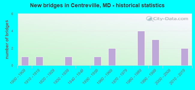
- New bridges - historical statistics
- 11900-1909
- 11910-1919
- 11930-1939
- 11950-1959
- 21960-1969
- 41980-1989
- 31990-1999
- 22010-2019
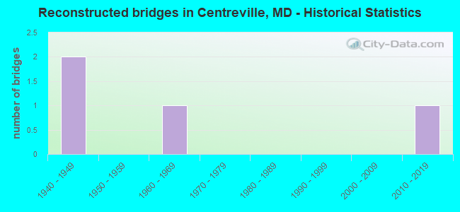
- Reconstructed bridges - Historical Statistics
- 21940-1949
- 01950-1959
- 11960-1969
- 01970-1979
- 01980-1989
- 01990-1999
- 02000-2009
- 12010-2019
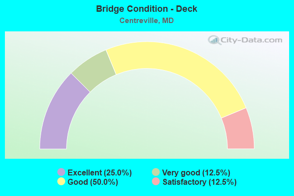
- Bridge Condition - Deck
- 25.0%Excellent
- 12.5%Very good
- 50.0%Good
- 12.5%Satisfactory
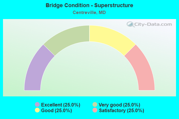
- Bridge Condition - Superstructure
- 25.0%Excellent
- 25.0%Very good
- 25.0%Good
- 25.0%Satisfactory
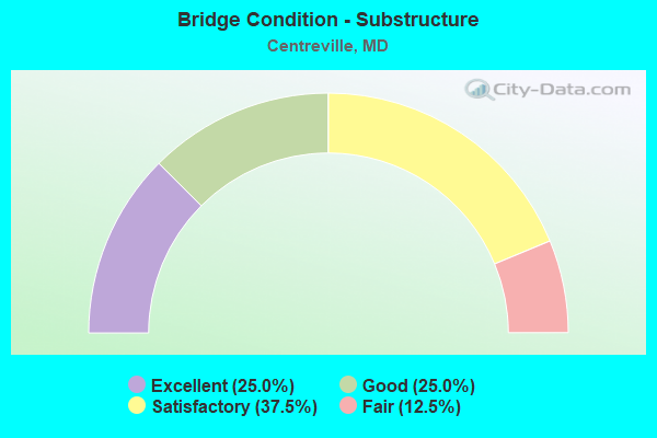
- Bridge Condition - Substructure
- 25.0%Excellent
- 25.0%Good
- 37.5%Satisfactory
- 12.5%Fair
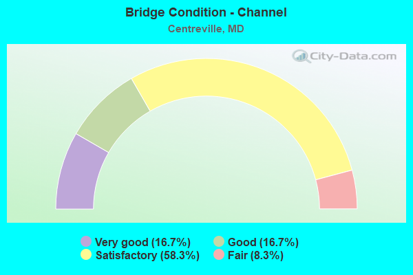
- Bridge Condition - Channel
- 16.7%Very good
- 16.7%Good
- 58.3%Satisfactory
- 8.3%Fair
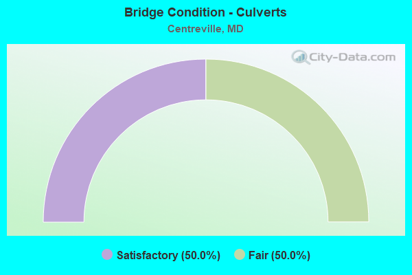
- Bridge Condition - Culverts
- 50.0%Satisfactory
- 50.0%Fair
Find on map >> Show street view
Structure Number: 10000017001502, Location: 0.89 MILE SOUTH OF MD 304 (Lat: 39.020081, Lng: -76.039372), Route carried "on" structure: US 301, Year Built: 1954, Year Reconstructed: 1965, Status: Open, Structure Length: 6.22m (20.41ft), Average Daily Traffic: 17,367 (year 2009), Truck Traffic: 8%, Average Future Daily Traffic: 22,991 (year 2026), Design Load: HS 20, Features Intersected: OLD MILL STREAM BRANCH
Minimum Vertical Clearance: 30+ m (98+ ft), Kilometerpoint: 31.552, Lanes on structure: 4, Base Highway Network: Yes, Owner: State Highway Agency, Approaching Roadway Width: 36.0m (118.1ft), Material/Design: Concrete, Design/Construction: Culvert, Length of Maximum Span: 4.0m (13.1ft)
Condition: Channel: Very good, Culverts: Satisfactory, Operating Rating: 32.7 metric tons, Method Used To Determine Operating Rating: Field evaluation and documented engineering judgment, Inventory Rating: 32.7 metric tons, Method Used To Determine Inventory Rating: Field evaluation and documented engineering judgment, Structural Evaluation: Equal to present minimum criteria, Waterway Adequacy: Equal to present desirable criteria, Approach Roadway Alignment: Equal to present desirable criteria, Designated Inspection Frequency: Every 24 months, Inspection Date: November 2021
Find on map >> Show street view
Structure Number: 10000017001801, Location: 2.9 MILES SOUTH OF MD 19A (Lat: 39.107606, Lng: -76.027378), Route carried "on" structure: State highway 213, Year Built: 1910, Year Reconstructed: 1953, Status: Open, Structure Length: 1.07m (3.51ft), Average Daily Traffic: 6,761 (year 2009), Truck Traffic: 8%, Average Future Daily Traffic: 9,110 (year 2026), Design Load: H 20, Features Intersected: GRANNY FINLEY BRANCH
Minimum Vertical Clearance: 30+ m (98+ ft), Kilometerpoint: 20.684, Lanes on structure: 2, Base Highway Network: Yes, Owner: State Highway Agency, Approaching Roadway Width: 11.3m (37.1ft), Material/Design: Concrete, Design/Construction: Slab, Number Of Spans In Main Unit: 2, Length of Maximum Span: 4.6m (15.1ft), Curb-To-Curb Width: 12.2m (40.0ft), Out-to-Out Width: 12.8m (42.0ft)
Condition: Deck: Satisfactory, Superstructure: Satisfactory, Substructure: Satisfactory, Channel: Good, Operating Rating: 59.0 metric tons, Method Used To Determine Operating Rating: Load Factor (LF), Inventory Rating: 35.4 metric tons, Method Used To Determine Inventory Rating: Load Factor (LF), Structural Evaluation: Equal to present minimum criteria, Deck Geometry: Somewhat better than minimum adequacy, Waterway Adequacy: Superior to present desirable criteria, Approach Roadway Alignment: Equal to present desirable criteria, Length Of Structure Improvement: 1.07m (3.51ft), Designated Inspection Frequency: Every 24 months, Inspection Date: June 2020, Bridge Improvement Cost: $88,000, Roadway Improvement Cost: $9,000, Total Project Cost: $97,000, Deck Structure Type: Concrete Cast-file-Place, Wearing Surface/Protective System: Wearing Surface: Bituminous
Find on map >> Show street view
Structure Number: 10000017001901, Location: 0.39 MILE NORTH OF MD 305 (Lat: 39.094950, Lng: -76.054594), Route carried "on" structure: State highway 213, Year Built: 1909, Year Reconstructed: 1953, Status: Open, Structure Length: 2.29m (7.51ft), Average Daily Traffic: 6,761 (year 0009), Truck Traffic: 8%, Average Future Daily Traffic: 9,110 (year 0026), Design Load: H 20, Features Intersected: THREE BRIDGES BRANCH
Minimum Vertical Clearance: 30+ m (98+ ft), Kilometerpoint: 13.668, Lanes on structure: 2, Base Highway Network: Yes, Owner: State Highway Agency, Approaching Roadway Width: 11.6m (38.1ft), Skew: 1 degrees, Material/Design: Concrete, Design/Construction: Tee Beam, Number Of Spans In Main Unit: 2, Length of Maximum Span: 11.0m (36.1ft), Curb or Sidewalk Widths: Left: 1.6m (5.2ft), Right: 1.6m (5.2ft), Curb-To-Curb Width: 10.8m (35.4ft), Out-to-Out Width: 11.9m (39.0ft)
Condition: Deck: Good, Superstructure: Satisfactory, Substructure: Fair, Channel: Satisfactory, Operating Rating: 52.2 metric tons, Method Used To Determine Operating Rating: Load Factor (LF), Inventory Rating: 31.3 metric tons, Method Used To Determine Inventory Rating: Load Factor (LF), Structural Evaluation: Somewhat better than minimum adequacy, Deck Geometry: Meets minimum limits, Waterway Adequacy: Equal to present minimum criteria, Approach Roadway Alignment: Equal to present desirable criteria, Length Of Structure Improvement: 2.29m (7.51ft), Designated Inspection Frequency: Every 12 months, Inspection Date: November 2021, Bridge Improvement Cost: $191,000, Roadway Improvement Cost: $19,000, Total Project Cost: $210,000, Deck Structure Type: Concrete Cast-file-Place, Wearing Surface/Protective System: Wearing Surface: Bituminous
Find on map >> Show street view
Structure Number: 10000017002001, Location: 0.22 MILE SOUTH OF MD 305 (Lat: 39.048192, Lng: -76.062253), Route carried "on" structure: State highway 213, Year Built: 1932, Year Reconstructed: 2019, Status: Open, Structure Length: 0.70m (2.30ft), Average Daily Traffic: 11,625 (year 2014), Truck Traffic: 5%, Average Future Daily Traffic: 14,475 (year 2030), Design Load: HS 20, Features Intersected: GRAVEL RUN
Minimum Vertical Clearance: 30+ m (98+ ft), Kilometerpoint: 12.661, Lanes on structure: 2, Base Highway Network: Yes, Owner: State Highway Agency, Approaching Roadway Width: 10.4m (34.1ft), Material/Design: Concrete, Design/Construction: Slab, Number Of Spans In Main Unit: 1, Length of Maximum Span: 6.4m (21.0ft), Curb or Sidewalk Widths: Left: 0.0m, Right: 1.6m (5.2ft), Curb-To-Curb Width: 10.1m (33.1ft), Out-to-Out Width: 12.9m (42.3ft)
Condition: Deck: Very good, Superstructure: Very good, Substructure: Satisfactory, Channel: Satisfactory, Operating Rating: 83.3 metric tons, Method Used To Determine Operating Rating: Load and Resistance Factor Rating (LRFR) rating reported by rating factor(RF) method using HL-93 loadings, Inventory Rating: 64.2 metric tons, Method Used To Determine Inventory Rating: Load and Resistance Factor Rating (LRFR) rating reported by rating factor(RF) method using HL-93 loadings, Structural Evaluation: Equal to present minimum criteria, Deck Geometry: Meets minimum limits, Waterway Adequacy: Better than present minimum criteria, Approach Roadway Alignment: Equal to present minimum criteria, Length Of Structure Improvement: 0.70m (2.30ft), Designated Inspection Frequency: Every 24 months, Inspection Date: November 2021, Bridge Improvement Cost: $58,000, Roadway Improvement Cost: $6,000, Total Project Cost: $64,000, Deck Structure Type: Concrete Cast-file-Place, Wearing Surface/Protective System: Wearing Surface: Bituminous
Find on map >> Show street view
Structure Number: 10000017002102, Location: 0.29 MILE NORTH OF MD 18C (Lat: 39.040117, Lng: -76.072369), Route carried "on" structure: State highway 213, Year Built: 2019, Status: Open, Structure Length: 2.26m (7.41ft), Average Daily Traffic: 17,000 (year 2014), Truck Traffic: 7%, Average Future Daily Traffic: 25,250 (year 2034), Design Load: H 20, Features Intersected: MILL STREAM BRANCH
Minimum Vertical Clearance: 30+ m (98+ ft), Kilometerpoint: 11.311, Lanes on structure: 2, Base Highway Network: Yes, Owner: State Highway Agency, Approaching Roadway Width: 12.2m (40.0ft), Material/Design: Steel, Design/Construction: Stringer/Multi-beam, Number Of Spans In Main Unit: 1, Length of Maximum Span: 20.7m (67.9ft), Curb or Sidewalk Widths: Left: 0.0m, Right: 1.7m (5.6ft), Curb-To-Curb Width: 12.3m (40.4ft), Out-to-Out Width: 15.2m (49.9ft)
Condition: Deck: Excellent, Superstructure: Excellent, Substructure: Excellent, Channel: Very good, Operating Rating: 79.4 metric tons, Method Used To Determine Operating Rating: Load and Resistance Factor Rating (LRFR) rating reported by rating factor(RF) method using HL-93 loadings, Inventory Rating: 61.2 metric tons, Method Used To Determine Inventory Rating: Load and Resistance Factor Rating (LRFR) rating reported by rating factor(RF) method using HL-93 loadings, Structural Evaluation: Superior to present desirable criteria, Deck Geometry: Somewhat better than minimum adequacy, Waterway Adequacy: Equal to present minimum criteria, Approach Roadway Alignment: Equal to present minimum criteria, Length Of Structure Improvement: 1.07m (3.51ft), Designated Inspection Frequency: Every 24 months, Underwater Inspection Frequency: Every 48 months, Inspection Date: November 2021, Underwater Inspection Date: September 2021, Bridge Improvement Cost: $106,000, Roadway Improvement Cost: $11,000, Total Project Cost: $117,000, Deck Structure Type: Concrete Cast-file-Place, Wearing Surface/Protective System: Wearing Surface: Bituminous
Find on map >> Show street view
Structure Number: 10000017002203, Location: 0.55 MILE SOUTH OF MD 309 (Lat: 38.992469, Lng: -76.075306), Route carried "on" structure: State highway 213, Year Built: 1962, Status: Open, Structure Length: 3.17m (10.40ft), Average Daily Traffic: 6,741 (year 2009), Truck Traffic: 8%, Average Future Daily Traffic: 8,995 (year 2026), Design Load: HS 20, Features Intersected: BR OF WYE RIVER
Minimum Vertical Clearance: 30+ m (98+ ft), Kilometerpoint: 5.852, Lanes on structure: 2, Base Highway Network: Yes, Owner: State Highway Agency, Approaching Roadway Width: 13.4m (44.0ft), Skew: 2 degrees, Material/Design: Steel, Design/Construction: Culvert, Length of Maximum Span: 4.0m (13.1ft)
Condition: Channel: Satisfactory, Culverts: Satisfactory, Operating Rating: 32.7 metric tons, Method Used To Determine Operating Rating: Field evaluation and documented engineering judgment, Inventory Rating: 32.7 metric tons, Method Used To Determine Inventory Rating: Field evaluation and documented engineering judgment, Structural Evaluation: Equal to present minimum criteria, Waterway Adequacy: Better than present minimum criteria, Approach Roadway Alignment: Equal to present desirable criteria, Designated Inspection Frequency: Every 24 months, Inspection Date: July 2020
Find on map >> Show street view
Structure Number: 10000017002901, Location: 0.88 MILE WEST OF MD 213 (Lat: 39.053128, Lng: -76.075583), Route carried "on" structure: State highway 304, Year Built: 1985, Status: Open, Structure Length: 2.87m (9.42ft), Average Daily Traffic: 1,732 (year 2006), Truck Traffic: 8%, Average Future Daily Traffic: 1,997 (year 2026), Design Load: HS 20, Features Intersected: CORSICA CREEK
Minimum Vertical Clearance: 30+ m (98+ ft), Kilometerpoint: 3.862, Lanes on structure: 2, Owner: State Highway Agency, Approaching Roadway Width: 8.8m (28.9ft), Material/Design: Steel continuous, Design/Construction: Stringer/Multi-beam, Number Of Spans In Main Unit: 2, Length of Maximum Span: 13.7m (44.9ft), Curb-To-Curb Width: 8.8m (28.9ft), Out-to-Out Width: 9.8m (32.2ft)
Condition: Deck: Good, Superstructure: Good, Substructure: Good, Channel: Good, Operating Rating: 69.8 metric tons, Method Used To Determine Operating Rating: Load Factor (LF), Inventory Rating: 41.7 metric tons, Method Used To Determine Inventory Rating: Load Factor (LF), Structural Evaluation: Better than present minimum criteria, Deck Geometry: Somewhat better than minimum adequacy, Waterway Adequacy: Superior to present desirable criteria, Approach Roadway Alignment: Equal to present desirable criteria, Designated Inspection Frequency: Every 24 months, Underwater Inspection Frequency: Every 48 months, Inspection Date: April 2021, Underwater Inspection Date: June 2020, Deck Structure Type: Concrete Cast-file-Place, Wearing Surface/Protective System: Wearing Surface: Monolithic Concrete, Deck Protection: Epoxy Coated Reinforcing
Find on map >> Show street view
Structure Number: 10000017004102, Location: 2.55 MILES N OF MD 305 (Lat: 39.078536, Lng: -76.034639), Route carried "on" structure: State highway 213, Year Built: 1961, Status: Open, Structure Length: 1.40m (4.59ft), Average Daily Traffic: 6,761 (year 2009), Truck Traffic: 8%, Average Future Daily Traffic: 9,110 (year 2026), Design Load: HS 20, Features Intersected: ISLAND CREEK
Minimum Vertical Clearance: 30+ m (98+ ft), Kilometerpoint: 17.131, Lanes on structure: 2, Base Highway Network: Yes, Owner: State Highway Agency, Approaching Roadway Width: 13.4m (44.0ft), Material/Design: Concrete, Design/Construction: Culvert, Length of Maximum Span: 4.3m (14.1ft)
Condition: Channel: Satisfactory, Culverts: Fair, Operating Rating: 32.7 metric tons, Method Used To Determine Operating Rating: Field evaluation and documented engineering judgment, Inventory Rating: 32.7 metric tons, Method Used To Determine Inventory Rating: Field evaluation and documented engineering judgment, Structural Evaluation: Somewhat better than minimum adequacy, Waterway Adequacy: Equal to present desirable criteria, Approach Roadway Alignment: Equal to present desirable criteria, Designated Inspection Frequency: Every 24 months, Inspection Date: July 2020
Find on map >> Show street view
Structure Number: 10000017005001, Location: 1.02 MILES N OF MD 309 (Lat: 39.014589, Lng: -76.076272), Route carried "on" structure: State highway 213, Year Built: 1994, Status: Open, Structure Length: 5.88m (19.29ft), Average Daily Traffic: 13,421 (year 2009), Truck Traffic: 8%, Average Future Daily Traffic: 17,100 (year 2026), Design Load: HS 25 or greater, Features Intersected: US 301
Minimum Vertical Clearance: 30+ m (98+ ft), Kilometerpoint: 8.383, Lanes on structure: 4, Lanes under structure: 5, Base Highway Network: Yes, Owner: State Highway Agency, Approaching Roadway Width: 20.1m (65.9ft), Material/Design: Steel continuous, Design/Construction: Stringer/Multi-beam, Number Of Spans In Main Unit: 2, Length of Maximum Span: 30.5m (100.1ft), Curb-To-Curb Width: 18.6m (61.0ft), Out-to-Out Width: 19.8m (65.0ft)
Condition: Deck: Good, Superstructure: Very good, Substructure: Good, Operating Rating: 85.3 metric tons, Method Used To Determine Operating Rating: Load Factor (LF), Inventory Rating: 50.8 metric tons, Method Used To Determine Inventory Rating: Load Factor (LF), Structural Evaluation: Better than present minimum criteria, Deck Geometry: Equal to present minimum criteria, Underclear: Equal to present minimum criteria, Approach Roadway Alignment: Equal to present desirable criteria, Designated Inspection Frequency: Every 24 months, Inspection Date: January 2021, Deck Structure Type: Concrete Cast-file-Place, Wearing Surface/Protective System: Wearing Surface: Monolithic Concrete, Deck Protection: Epoxy Coated Reinforcing
Find on map >> Show street view
Structure Number: 10000017005701, Location: 2.5 MI E OF MD 213 (Lat: 39.027597, Lng: -76.027006), Route carried "on" structure: State highway 304, Year Built: 2017, Status: Open, Structure Length: 8.32m (27.30ft), Average Daily Traffic: 4,525 (year 2013), Truck Traffic: 11%, Average Future Daily Traffic: 6,725 (year 2033), Features Intersected: US 301
Minimum Vertical Clearance: 30+ m (98+ ft), Kilometerpoint: 9.316, Lanes on structure: 2, Lanes under structure: 5, Owner: State Highway Agency, Approaching Roadway Width: 14.0m (45.9ft), Skew: 21 degrees, Material/Design: Steel continuous, Design/Construction: Stringer/Multi-beam, Number Of Spans In Main Unit: 2, Length of Maximum Span: 42.7m (140.1ft), Curb or Sidewalk Widths: Left: 1.7m (5.6ft), Right: 1.7m (5.6ft), Curb-To-Curb Width: 12.8m (42.0ft), Out-to-Out Width: 18.3m (60.0ft)
Condition: Deck: Excellent, Superstructure: Excellent, Substructure: Excellent, Operating Rating: 48.3 metric tons, Method Used To Determine Operating Rating: Load and Resistance Factor Rating (LRFR) rating reported by rating factor(RF) method using HL-93 loadings, Inventory Rating: 37.3 metric tons, Method Used To Determine Inventory Rating: Load and Resistance Factor Rating (LRFR) rating reported by rating factor(RF) method using HL-93 loadings, Structural Evaluation: Superior to present desirable criteria, Deck Geometry: Equal to present minimum criteria, Underclear: Equal to present minimum criteria, Approach Roadway Alignment: Equal to present desirable criteria, Designated Inspection Frequency: Every 24 months, Inspection Date: January 2022, Deck Structure Type: Concrete Cast-file-Place, Wearing Surface/Protective System: Wearing Surface: Monolithic Concrete, Deck Protection: Epoxy Coated Reinforcing
Find on map >> Show street view
Structure Number: 200000Q-001901, Location: .26 MI SE OF LANDS END RD (Lat: 39.117325, Lng: -76.068411), Route carried "on" structure: County highway 103, Year Built: 1989, Status: Open, Structure Length: 1.59m (5.22ft), Average Daily Traffic: 387 (year 2020), Truck Traffic: 5%, Average Future Daily Traffic: 473 (year 2040), Design Load: HS 20, Features Intersected: ISLAND CREEK, Facility Carried by Structure: SPARKS MILL ROAD
Minimum Vertical Clearance: 30+ m (98+ ft), Kilometerpoint: 0.402, Lanes on structure: 2, Owner: County Highway Agency, Approaching Roadway Width: 9.1m (29.9ft), Material/Design: Steel, Design/Construction: Culvert, Length of Maximum Span: 3.4m (11.2ft)
Condition: Channel: Fair, Culverts: Fair, Inventory Rating: 72.1 metric tons, Method Used To Determine Inventory Rating: Load Factor (LF), Structural Evaluation: Somewhat better than minimum adequacy, Waterway Adequacy: Equal to present minimum criteria, Approach Roadway Alignment: Equal to present desirable criteria, Designated Inspection Frequency: Every 24 months, Inspection Date: May 2020
Find on map >> Show street view
Structure Number: 200000Q-002003, Location: 1.1 MI. WEST OF MD 213 (Lat: 39.115339, Lng: -76.040889), Route carried "on" structure: County highway 103, Year Built: 1985, Status: Open, Structure Length: 1.46m (4.79ft), Average Daily Traffic: 221 (year 2020), Truck Traffic: 5%, Average Future Daily Traffic: 270 (year 2040), Design Load: HS 20, Features Intersected: GRANNY FINLEY BRANCH, Facility Carried by Structure: SPARKS MILL ROAD
Minimum Vertical Clearance: 30+ m (98+ ft), Kilometerpoint: 2.928, Lanes on structure: 2, Owner: County Highway Agency, Approaching Roadway Width: 8.5m (27.9ft), Material/Design: Steel, Design/Construction: Culvert, Length of Maximum Span: 3.0m (9.8ft)
Condition: Channel: Satisfactory, Culverts: Satisfactory, Operating Rating: 82.1 metric tons, Method Used To Determine Operating Rating: Load Factor (LF), Inventory Rating: 79.8 metric tons, Method Used To Determine Inventory Rating: Load Factor (LF), Structural Evaluation: Equal to present minimum criteria, Waterway Adequacy: Equal to present minimum criteria, Approach Roadway Alignment: Equal to present desirable criteria, Designated Inspection Frequency: Every 24 months, Inspection Date: April 2020
Find on map >> Show street view
Structure Number: 200000Q-002103, Location: 0.3 MI. E. BURRISVILLE RD (Lat: 39.097675, Lng: -76.063908), Route carried "on" structure: County highway 112, Year Built: 1982, Status: Open, Structure Length: 1.22m (4.00ft), Average Daily Traffic: 332 (year 2020), Truck Traffic: 5%, Average Future Daily Traffic: 405 (year 2040), Design Load: HS 20, Features Intersected: ISLAND CREEK, Facility Carried by Structure: COON BOX ROAD
Minimum Vertical Clearance: 30+ m (98+ ft), Kilometerpoint: 2.076, Lanes on structure: 2, Owner: County Highway Agency, Approaching Roadway Width: 9.1m (29.9ft), Material/Design: Steel, Design/Construction: Culvert, Length of Maximum Span: 3.7m (12.1ft)
Condition: Channel: Satisfactory, Culverts: Fair, Operating Rating: 88.0 metric tons, Method Used To Determine Operating Rating: Load Factor (LF), Inventory Rating: 88.0 metric tons, Method Used To Determine Inventory Rating: Load Factor (LF), Structural Evaluation: Somewhat better than minimum adequacy, Waterway Adequacy: Equal to present minimum criteria, Approach Roadway Alignment: Equal to present desirable criteria, Designated Inspection Frequency: Every 24 months, Inspection Date: April 2020
Find on map >> Show street view
Structure Number: 200000Q-002901, Location: 0.2 MI N OF MD RTE 304 (Lat: 39.055008, Lng: -76.075161), Route carried "on" structure: County highway 135, Year Built: 1993, Status: Open, Structure Length: 1.40m (4.59ft), Average Daily Traffic: 731 (year 2018), Truck Traffic: 2%, Average Future Daily Traffic: 1,059 (year 2038), Design Load: HS 20, Features Intersected: CORSICA RIVER, Facility Carried by Structure: WATSON ROAD
Minimum Vertical Clearance: 30+ m (98+ ft), Kilometerpoint: 0.434, Lanes on structure: 2, Owner: County Highway Agency, Approaching Roadway Width: 8.8m (28.9ft), Material/Design: Wood or Timber, Design/Construction: Stringer/Multi-beam, Number Of Spans In Main Unit: 2, Length of Maximum Span: 7.3m (24.0ft), Curb-To-Curb Width: 9.4m (30.8ft), Out-to-Out Width: 10.1m (33.1ft)
Condition: Deck: Good, Superstructure: Good, Substructure: Satisfactory, Channel: Satisfactory, Inventory Rating: 68.0 metric tons, Method Used To Determine Inventory Rating: Allowable Stress (AS), Structural Evaluation: Equal to present minimum criteria, Deck Geometry: Equal to present minimum criteria, Waterway Adequacy: Better than present minimum criteria, Approach Roadway Alignment: Equal to present desirable criteria, Designated Inspection Frequency: Every 24 months, Underwater Inspection Frequency: Every 48 months, Inspection Date: May 2020, Underwater Inspection Date: May 2020, Deck Structure Type: Wood or Timber, Wearing Surface/Protective System: Wearing Surface: Bituminous
Find on map >> Show street view
Structure Number: 10000017005001, Location: 0.71 M N OF PERLEE ROAD (Lat: 39.014589, Lng: -76.076272), Route carried "under" structure: US 301, Year Built: 1994, Structure Length: 0. m, Average Daily Traffic: 17,367 (year 2009), Truck Traffic: 8%, Features Intersected: US 301, Facility Carried by Structure: MD 213
Minimum Vertical Clearance: 5.18m (16.99ft), Kilometerpoint: 28.286, Lanes on structure: 4, Lanes under structure: 5, Material/Design: Steel continuous, Design/Construction: Stringer/Multi-beam, Length of Maximum Span: 30.5m (100.1ft)