Bridge Statistics for Chenango, New York (NY)
Condition, Traffic, Stress, Structural Evaluation, Project Costs
- National Bridge Inventory (NBI) Statistics
- 45Number of bridges
- 856ft / 261mTotal length
- $115,021,000Total costs
- 392,903Total average daily traffic
- 48,785Total average daily truck traffic
- National Bridge Inventory (NBI) Registered Bridges for Chenango
- No street view available for this location

- New bridges - historical statistics
- 11920-1929
- 11930-1939
- 11940-1949
- 11950-1959
- 241960-1969
- 51970-1979
- 91980-1989
- 11990-1999
- 12000-2009
- 12010-2019
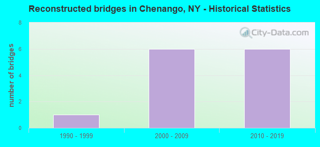
- Reconstructed bridges - Historical Statistics
- 11990-1999
- 62000-2009
- 62010-2019
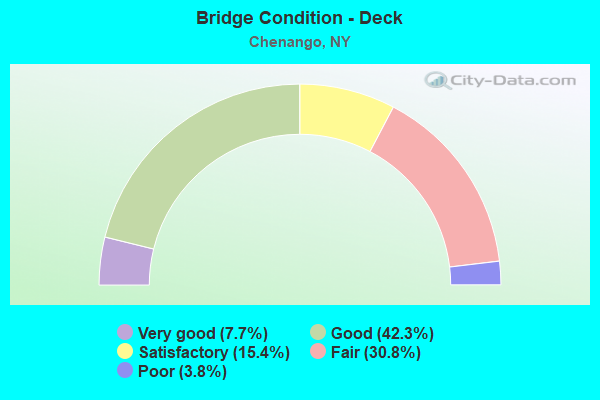
- Bridge Condition - Deck
- 7.7%Very good
- 42.3%Good
- 15.4%Satisfactory
- 30.8%Fair
- 3.8%Poor
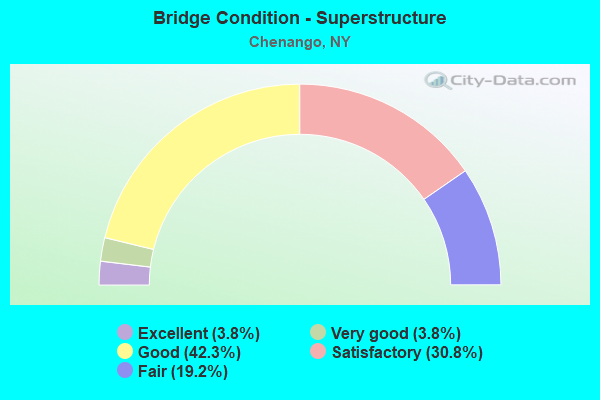
- Bridge Condition - Superstructure
- 3.8%Excellent
- 3.8%Very good
- 42.3%Good
- 30.8%Satisfactory
- 19.2%Fair
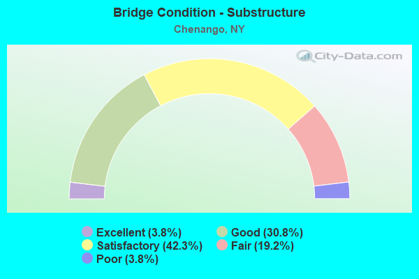
- Bridge Condition - Substructure
- 3.8%Excellent
- 30.8%Good
- 42.3%Satisfactory
- 19.2%Fair
- 3.8%Poor
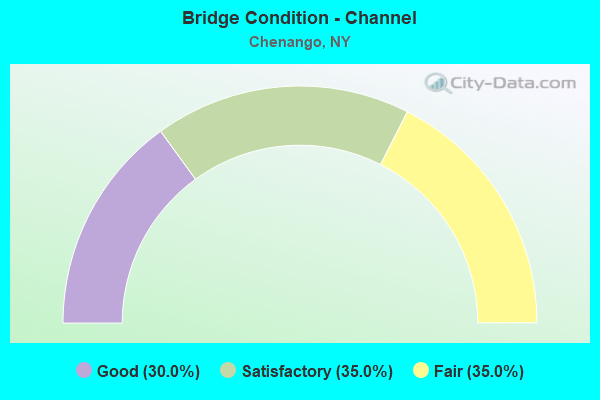
- Bridge Condition - Channel
- 30.0%Good
- 35.0%Satisfactory
- 35.0%Fair
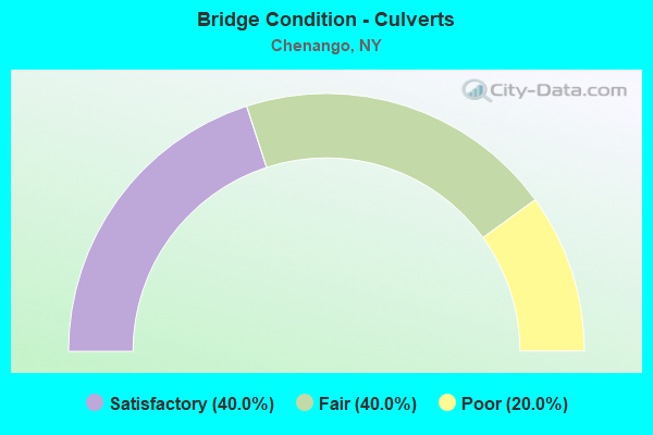
- Bridge Condition - Culverts
- 40.0%Satisfactory
- 40.0%Fair
- 20.0%Poor
Find on map >> Show street view
Structure Number: 1008201, Location: 2.5 MI N OF N BING CTY LI (Lat: 42.152931, Lng: -75.897517), Route carried "on" structure: Interstate 81, Year Built: 1966, Status: Open, Structure Length: 6.10m (20.01ft), Average Daily Traffic: 19,521 (year 2010), Truck Traffic: 26%, Design Load: HS 20+Mod, Features Intersected: RTE 11
Minimum Vertical Clearance: 30+ m (98+ ft), Kilometerpoint: 25.438, Lanes on structure: 3, Lanes under structure: 3, Base Highway Network: Yes, Owner: State Highway Agency, Approaching Roadway Width: 14.3m (46.9ft), Skew: 5 degrees, Material/Design: Steel, Design/Construction: Stringer/Multi-beam, Number Of Spans In Main Unit: 3, Length of Maximum Span: 32.0m (105.0ft), Curb or Sidewalk Widths: Left: 0.5m (1.6ft), Right: 0.5m (1.6ft), Curb-To-Curb Width: 12.2m (40.0ft), Out-to-Out Width: 13.8m (45.3ft)
Condition: Deck: Good, Superstructure: Good, Substructure: Satisfactory, Operating Rating: 46.3 metric tons, Method Used To Determine Operating Rating: Load and Resistance Factor Rating (LRFR) rating reported by rating factor(RF) method using HL-93 loadings, Inventory Rating: 35.6 metric tons, Method Used To Determine Inventory Rating: Load and Resistance Factor Rating (LRFR) rating reported by rating factor(RF) method using HL-93 loadings, Structural Evaluation: Equal to present minimum criteria, Deck Geometry: High priority of corrective action, Underclear: Meets minimum limits, Approach Roadway Alignment: Equal to present desirable criteria, Length Of Structure Improvement: 6.09m (19.98ft), Designated Inspection Frequency: Every 24 months, Inspection Date: July 2021, Bridge Improvement Cost: $1,920,000, Roadway Improvement Cost: $1,124,000, Total Project Cost: $3,044,000 ( Estimate for 2021), Deck Structure Type: Concrete Cast-file-Place, Wearing Surface/Protective System: Wearing Surface: Integral Concrete
Find on map >> Show street view
Structure Number: 1008202, Location: 2.5 MI N OF N BING CTY LI (Lat: 42.153278, Lng: -75.897308), Route carried "on" structure: Interstate 81, Year Built: 1966, Status: Open, Structure Length: 6.37m (20.90ft), Average Daily Traffic: 16,176 (year 2020), Truck Traffic: 29%, Average Future Daily Traffic: 21,277 (year 2040), Design Load: HS 20+Mod, Features Intersected: RTE 11
Minimum Vertical Clearance: 30+ m (98+ ft), Kilometerpoint: 25.438, Lanes on structure: 2, Lanes under structure: 3, Base Highway Network: Yes, Owner: State Highway Agency, Approaching Roadway Width: 10.7m (35.1ft), Skew: 5 degrees, Material/Design: Steel, Design/Construction: Stringer/Multi-beam, Number Of Spans In Main Unit: 3, Length of Maximum Span: 33.8m (110.9ft), Curb or Sidewalk Widths: Left: 0.5m (1.6ft), Right: 0.5m (1.6ft), Curb-To-Curb Width: 8.5m (27.9ft), Out-to-Out Width: 10.1m (33.1ft)
Condition: Deck: Good, Superstructure: Good, Substructure: Satisfactory, Operating Rating: 47.0 metric tons, Method Used To Determine Operating Rating: Load and Resistance Factor Rating (LRFR) rating reported by rating factor(RF) method using HL-93 loadings, Inventory Rating: 36.3 metric tons, Method Used To Determine Inventory Rating: Load and Resistance Factor Rating (LRFR) rating reported by rating factor(RF) method using HL-93 loadings, Structural Evaluation: Equal to present minimum criteria, Deck Geometry: High priority of corrective action, Underclear: Meets minimum limits, Approach Roadway Alignment: Equal to present desirable criteria, Length Of Structure Improvement: 6.37m (20.90ft), Designated Inspection Frequency: Every 24 months, Inspection Date: July 2021, Bridge Improvement Cost: $1,465,000, Roadway Improvement Cost: $858,000, Total Project Cost: $2,323,000 ( Estimate for 2021), Deck Structure Type: Concrete Cast-file-Place, Wearing Surface/Protective System: Wearing Surface: Integral Concrete
Find on map >> Show street view
Structure Number: 100821, Location: 0.1 MI S JCT US 11 & SH 1 (Lat: 42.160367, Lng: -75.894669), Route carried "on" structure: US 11, Year Built: 1983, Status: Open, Structure Length: 1.25m (4.10ft), Average Daily Traffic: 22,031 (year 2019), Truck Traffic: 4%, Average Future Daily Traffic: 22,471 (year 2040), Design Load: HS 20, Features Intersected: DORMAN CREEK
Minimum Vertical Clearance: 30+ m (98+ ft), Kilometerpoint: 27.932, Lanes on structure: 4, Base Highway Network: Yes, Owner: State Highway Agency, Approaching Roadway Width: 20.7m (67.9ft), Skew: 20 degrees, Material/Design: Prestressed concrete, Design/Construction: Box Beam or Girders - Multiple, Number Of Spans In Main Unit: 1, Length of Maximum Span: 12.1m (39.7ft), Curb or Sidewalk Widths: Left: 1.5m (4.9ft), Right: 1.5m (4.9ft), Curb-To-Curb Width: 20.7m (67.9ft), Out-to-Out Width: 24.5m (80.4ft)
Condition: Deck: Fair, Superstructure: Fair, Substructure: Satisfactory, Channel: Satisfactory, Operating Rating: 79.8 metric tons, Method Used To Determine Operating Rating: Load Factor (LF), Inventory Rating: 47.2 metric tons, Method Used To Determine Inventory Rating: Load Factor (LF), Structural Evaluation: Somewhat better than minimum adequacy, Deck Geometry: Superior to present desirable criteria, Waterway Adequacy: Equal to present desirable criteria, Approach Roadway Alignment: Equal to present desirable criteria, Length Of Structure Improvement: 1.24m (4.07ft), Designated Inspection Frequency: Every 24 months, Inspection Date: March 2020, Bridge Improvement Cost: $993,000, Roadway Improvement Cost: $581,000, Total Project Cost: $1,574,000 ( Estimate for 2021), Wearing Surface/Protective System: Wearing Surface: Monolithic Concrete
Find on map >> Show street view
Structure Number: 100822, Location: JCT US 11 & SH 12 (Lat: 42.161464, Lng: -75.893719), Route carried "on" structure: US 11, Year Built: 1975, Status: Open, Structure Length: 2.68m (8.79ft), Average Daily Traffic: 22,031 (year 2019), Truck Traffic: 4%, Average Future Daily Traffic: 22,471 (year 2040), Design Load: HS 20, Features Intersected: CASTLE CREEK
Minimum Vertical Clearance: 30+ m (98+ ft), Kilometerpoint: 28.045, Lanes on structure: 5, Base Highway Network: Yes, Owner: State Highway Agency, Approaching Roadway Width: 18.9m (62.0ft), Skew: 22 degrees, Material/Design: Prestressed concrete, Design/Construction: Box Beam or Girders - Multiple, Number Of Spans In Main Unit: 1, Length of Maximum Span: 25.6m (84.0ft), Curb or Sidewalk Widths: Left: 1.5m (4.9ft), Right: 1.5m (4.9ft), Curb-To-Curb Width: 18.9m (62.0ft), Out-to-Out Width: 22.7m (74.5ft)
Condition: Deck: Fair, Superstructure: Fair, Substructure: Fair, Channel: Fair, Operating Rating: 38.1 metric tons, Method Used To Determine Operating Rating: Load Factor (LF), Inventory Rating: 22.7 metric tons, Method Used To Determine Inventory Rating: Load Factor (LF), Structural Evaluation: Somewhat better than minimum adequacy, Deck Geometry: Meets minimum limits, Waterway Adequacy: Meets minimum limits, Approach Roadway Alignment: Equal to present desirable criteria, Length Of Structure Improvement: 2.68m (8.79ft), Designated Inspection Frequency: Every 24 months, Inspection Date: October 2021, Bridge Improvement Cost: $1,685,000, Roadway Improvement Cost: $987,000, Total Project Cost: $2,672,000 ( Estimate for 2021), Wearing Surface/Protective System: Wearing Surface: Integral Concrete
Find on map >> Show street view
Structure Number: 1008231, Location: 0.2 MI NW JCT RTS 11 + 12 (Lat: 42.164931, Lng: -75.896197), Route carried "on" structure: Interstate 81, Year Built: 1966, Year Reconstructed: 2017, Status: Open, Structure Length: 5.88m (19.29ft), Average Daily Traffic: 12,573 (year 2009), Truck Traffic: 27%, Design Load: HS 20+Mod, Features Intersected: RTE 11
Minimum Vertical Clearance: 30+ m (98+ ft), Kilometerpoint: 26.742, Lanes on structure: 2, Lanes under structure: 4, Base Highway Network: Yes, Owner: State Highway Agency, Approaching Roadway Width: 11.0m (36.1ft), Skew: 4 degrees, Material/Design: Steel, Design/Construction: Stringer/Multi-beam, Number Of Spans In Main Unit: 3, Length of Maximum Span: 26.2m (86.0ft), Curb-To-Curb Width: 9.2m (30.2ft), Out-to-Out Width: 10.1m (33.1ft)
Condition: Deck: Satisfactory, Superstructure: Fair, Substructure: Good, Operating Rating: 86.2 metric tons, Method Used To Determine Operating Rating: Load Factor (LF), Inventory Rating: 51.7 metric tons, Method Used To Determine Inventory Rating: Load Factor (LF), Structural Evaluation: Somewhat better than minimum adequacy, Deck Geometry: High priority of replacement, Underclear: Meets minimum limits, Approach Roadway Alignment: Equal to present desirable criteria, Length Of Structure Improvement: 5.88m (19.29ft), Designated Inspection Frequency: Every 24 months, Inspection Date: March 2021, Bridge Improvement Cost: $1,423,000, Roadway Improvement Cost: $833,000, Total Project Cost: $2,257,000 ( Estimate for 2021), Deck Structure Type: Concrete Cast-file-Place, Wearing Surface/Protective System: Wearing Surface: Monolithic Concrete
Find on map >> Show street view
Structure Number: 1008232, Location: 0.2 MI NW JCT RTS 11 + 12 (Lat: 42.164667, Lng: -75.895956), Route carried "on" structure: Interstate 81, Year Built: 1966, Year Reconstructed: 2017, Status: Open, Structure Length: 5.58m (18.31ft), Average Daily Traffic: 9,950 (year 2019), Truck Traffic: 29%, Average Future Daily Traffic: 13,087 (year 2040), Design Load: HS 20+Mod, Features Intersected: RTE 11
Minimum Vertical Clearance: 30+ m (98+ ft), Kilometerpoint: 26.742, Lanes on structure: 2, Lanes under structure: 4, Base Highway Network: Yes, Owner: State Highway Agency, Approaching Roadway Width: 11.0m (36.1ft), Skew: 4 degrees, Material/Design: Steel, Design/Construction: Stringer/Multi-beam, Number Of Spans In Main Unit: 3, Length of Maximum Span: 26.5m (86.9ft), Curb-To-Curb Width: 9.2m (30.2ft), Out-to-Out Width: 10.1m (33.1ft)
Condition: Deck: Satisfactory, Superstructure: Satisfactory, Substructure: Satisfactory, Operating Rating: 55.7 metric tons, Method Used To Determine Operating Rating: Load and Resistance Factor Rating (LRFR) rating reported by rating factor(RF) method using HL-93 loadings, Inventory Rating: 43.1 metric tons, Method Used To Determine Inventory Rating: Load and Resistance Factor Rating (LRFR) rating reported by rating factor(RF) method using HL-93 loadings, Structural Evaluation: Equal to present minimum criteria, Deck Geometry: High priority of replacement, Underclear: High priority of corrective action, Approach Roadway Alignment: Equal to present desirable criteria, Length Of Structure Improvement: 5.57m (18.27ft), Designated Inspection Frequency: Every 24 months, Inspection Date: March 2021, Bridge Improvement Cost: $1,327,000, Roadway Improvement Cost: $777,000, Total Project Cost: $2,104,000 ( Estimate for 2021), Deck Structure Type: Concrete Cast-file-Place, Wearing Surface/Protective System: Wearing Surface: Monolithic Concrete
Find on map >> Show street view
Structure Number: 100824, Location: 0.6MI N JCT RTS 11 & 12 (Lat: 42.168753, Lng: -75.899522), Route carried "on" structure: US 11, Year Built: 1990, Status: Open, Structure Length: 2.19m (7.19ft), Average Daily Traffic: 3,763 (year 2019), Truck Traffic: 6%, Average Future Daily Traffic: 4,571 (year 2040), Design Load: HS 20, Features Intersected: CASTLE CREEK
Minimum Vertical Clearance: 30+ m (98+ ft), Kilometerpoint: 29.059, Lanes on structure: 2, Base Highway Network: Yes, Owner: State Highway Agency, Approaching Roadway Width: 12.8m (42.0ft), Skew: 1 degrees, Material/Design: Prestressed concrete, Design/Construction: Box Beam or Girders - Multiple, Number Of Spans In Main Unit: 1, Length of Maximum Span: 20.7m (67.9ft), Curb-To-Curb Width: 12.8m (42.0ft), Out-to-Out Width: 13.6m (44.6ft)
Condition: Deck: Fair, Superstructure: Satisfactory, Substructure: Satisfactory, Channel: Satisfactory, Operating Rating: 59.0 metric tons, Method Used To Determine Operating Rating: Load Factor (LF), Inventory Rating: 35.4 metric tons, Method Used To Determine Inventory Rating: Load Factor (LF), Structural Evaluation: Equal to present minimum criteria, Deck Geometry: Equal to present minimum criteria, Waterway Adequacy: Somewhat better than minimum adequacy, Approach Roadway Alignment: Equal to present desirable criteria, Length Of Structure Improvement: 2.19m (7.19ft), Designated Inspection Frequency: Every 24 months, Inspection Date: September 2021, Bridge Improvement Cost: $928,000, Roadway Improvement Cost: $543,000, Total Project Cost: $1,471,000 ( Estimate for 2021), Wearing Surface/Protective System: Wearing Surface: Monolithic Concrete
Find on map >> Show street view
Structure Number: 100825, Location: 1.5 MI N JCT US 11 & SH 1 (Lat: 42.180797, Lng: -75.907319), Route carried "on" structure: US 11, Year Built: 1974, Status: Open, Structure Length: 0.88m (2.89ft), Average Daily Traffic: 1,559 (year 2020), Truck Traffic: 9%, Average Future Daily Traffic: 1,928 (year 2040), Design Load: HS 20, Features Intersected: GLEN CASTLE CREEK
Minimum Vertical Clearance: 30+ m (98+ ft), Kilometerpoint: 30.571, Lanes on structure: 2, Base Highway Network: Yes, Owner: State Highway Agency, Approaching Roadway Width: 9.8m (32.2ft), Skew: 1 degrees, Material/Design: Concrete continuous, Design/Construction: Culvert, Number Of Spans In Main Unit: 2, Length of Maximum Span: 3.9m (12.8ft), Curb-To-Curb Width: 10.4m (34.1ft), Out-to-Out Width: 11.1m (36.4ft)
Condition: Channel: Fair, Culverts: Satisfactory, Operating Rating: 50.8 metric tons, Method Used To Determine Operating Rating: Load Factor (LF), Inventory Rating: 29.9 metric tons, Method Used To Determine Inventory Rating: Load Factor (LF), Structural Evaluation: Equal to present minimum criteria, Deck Geometry: Equal to present minimum criteria, Waterway Adequacy: Meets minimum limits, Approach Roadway Alignment: Meets minimum limits, Length Of Structure Improvement: 0.88m (2.89ft), Designated Inspection Frequency: Every 24 months, Inspection Date: September 2021, Bridge Improvement Cost: $322,000, Roadway Improvement Cost: $189,000, Total Project Cost: $511,000 ( Estimate for 2021), Wearing Surface/Protective System: Wearing Surface: Bituminous
Find on map >> Show street view
Structure Number: 100826, Location: 1 MI S EXIT 7 OF I81 (Lat: 42.218936, Lng: -75.914436), Route carried "on" structure: US 11, Year Built: 1960, Status: Open, Structure Length: 1.07m (3.51ft), Average Daily Traffic: 1,559 (year 2020), Truck Traffic: 9%, Average Future Daily Traffic: 1,626 (year 2040), Design Load: HS 20+Mod, Features Intersected: BROOKS CREEK
Minimum Vertical Clearance: 30+ m (98+ ft), Kilometerpoint: 34.980, Lanes on structure: 2, Base Highway Network: Yes, Owner: State Highway Agency, Approaching Roadway Width: 12.2m (40.0ft), Skew: 2 degrees, Material/Design: Steel, Design/Construction: Stringer/Multi-beam, Number Of Spans In Main Unit: 1, Length of Maximum Span: 10.3m (33.8ft), Curb-To-Curb Width: 11.6m (38.1ft), Out-to-Out Width: 13.2m (43.3ft)
Condition: Deck: Fair, Superstructure: Satisfactory, Substructure: Satisfactory, Channel: Fair, Operating Rating: 82.6 metric tons, Method Used To Determine Operating Rating: Load Factor (LF), Inventory Rating: 49.0 metric tons, Method Used To Determine Inventory Rating: Load Factor (LF), Structural Evaluation: Equal to present minimum criteria, Deck Geometry: Equal to present minimum criteria, Waterway Adequacy: Meets minimum limits, Approach Roadway Alignment: Equal to present desirable criteria, Length Of Structure Improvement: 1.06m (3.48ft), Designated Inspection Frequency: Every 24 months, Inspection Date: September 2021, Bridge Improvement Cost: $602,000, Roadway Improvement Cost: $352,000, Total Project Cost: $954,000 ( Estimate for 2021), Deck Structure Type: Concrete Cast-file-Place, Wearing Surface/Protective System: Wearing Surface: Bituminous
Find on map >> Show street view
Structure Number: 100827, Location: .4 MI S EXIT 7 I81 ON US (Lat: 42.228281, Lng: -75.918525), Route carried "on" structure: US 11, Year Built: 1974, Status: Open, Structure Length: 0.85m (2.79ft), Average Daily Traffic: 1,315 (year 2016), Truck Traffic: 6%, Average Future Daily Traffic: 1,371 (year 2040), Design Load: HS 20, Features Intersected: POTATO CREEK
Minimum Vertical Clearance: 30+ m (98+ ft), Kilometerpoint: 36.090, Lanes on structure: 2, Base Highway Network: Yes, Owner: State Highway Agency, Approaching Roadway Width: 10.4m (34.1ft), Skew: 4 degrees, Material/Design: Concrete continuous, Design/Construction: Culvert, Number Of Spans In Main Unit: 2, Length of Maximum Span: 3.9m (12.8ft), Curb or Sidewalk Widths: Left: 1.5m (4.9ft), Right: 0.1m (0.3ft), Curb-To-Curb Width: 10.2m (33.5ft), Out-to-Out Width: 12.5m (41.0ft)
Condition: Channel: Fair, Culverts: Fair, Operating Rating: 71.7 metric tons, Method Used To Determine Operating Rating: Load Factor (LF), Inventory Rating: 42.6 metric tons, Method Used To Determine Inventory Rating: Load Factor (LF), Structural Evaluation: Somewhat better than minimum adequacy, Deck Geometry: Somewhat better than minimum adequacy, Waterway Adequacy: Meets minimum limits, Approach Roadway Alignment: Equal to present desirable criteria, Length Of Structure Improvement: 0.85m (2.79ft), Designated Inspection Frequency: Every 24 months, Inspection Date: October 2021, Bridge Improvement Cost: $436,000, Roadway Improvement Cost: $255,000, Total Project Cost: $691,000 ( Estimate for 2021), Wearing Surface/Protective System: Wearing Surface: Bituminous
Find on map >> Show street view
Structure Number: 100828, Location: .1 MI S EXIT 7 OF I-81 (Lat: 42.232361, Lng: -75.916297), Route carried "on" structure: US 11, Year Built: 1965, Status: Open, Structure Length: 1.25m (4.10ft), Average Daily Traffic: 1,315 (year 2016), Truck Traffic: 6%, Average Future Daily Traffic: 1,371 (year 2040), Features Intersected: CASTLE CREEK
Minimum Vertical Clearance: 30+ m (98+ ft), Kilometerpoint: 36.653, Lanes on structure: 2, Base Highway Network: Yes, Owner: State Highway Agency, Approaching Roadway Width: 13.4m (44.0ft), Skew: 3 degrees, Material/Design: Concrete continuous, Design/Construction: Culvert, Number Of Spans In Main Unit: 2, Length of Maximum Span: 5.7m (18.7ft), Curb-To-Curb Width: 13.4m (44.0ft), Out-to-Out Width: 14.3m (46.9ft)
Condition: Channel: Satisfactory, Culverts: Satisfactory, Operating Rating: 98.0 metric tons, Method Used To Determine Operating Rating: Load Factor (LF), Inventory Rating: 58.1 metric tons, Method Used To Determine Inventory Rating: Load Factor (LF), Structural Evaluation: Equal to present minimum criteria, Deck Geometry: Equal to present desirable criteria, Waterway Adequacy: Meets minimum limits, Approach Roadway Alignment: Equal to present desirable criteria, Length Of Structure Improvement: 1.24m (4.07ft), Designated Inspection Frequency: Every 24 months, Inspection Date: June 2020, Bridge Improvement Cost: $316,000, Roadway Improvement Cost: $185,000, Total Project Cost: $502,000 ( Estimate for 2021), Wearing Surface/Protective System: Wearing Surface: Bituminous
Find on map >> Show street view
Structure Number: 1008291, Location: EXIT 7 I-81 INT (Lat: 42.233094, Lng: -75.915367), Route carried "on" structure: Interstate 81, Year Built: 1967, Year Reconstructed: 2017, Status: Open, Structure Length: 5.03m (16.50ft), Average Daily Traffic: 12,949 (year 2013), Truck Traffic: 27%, Design Load: HS 20+Mod, Features Intersected: RTE 11
Minimum Vertical Clearance: 30+ m (98+ ft), Kilometerpoint: 34.803, Lanes on structure: 2, Lanes under structure: 2, Base Highway Network: Yes, Owner: State Highway Agency, Approaching Roadway Width: 11.0m (36.1ft), Skew: 3 degrees, Material/Design: Steel, Design/Construction: Stringer/Multi-beam, Number Of Spans In Main Unit: 3, Length of Maximum Span: 18.2m (59.7ft), Curb-To-Curb Width: 8.5m (27.9ft), Out-to-Out Width: 10.1m (33.1ft)
Condition: Deck: Fair, Superstructure: Satisfactory, Substructure: Satisfactory, Operating Rating: 78.0 metric tons, Method Used To Determine Operating Rating: Load Factor (LF), Inventory Rating: 46.3 metric tons, Method Used To Determine Inventory Rating: Load Factor (LF), Structural Evaluation: Equal to present minimum criteria, Deck Geometry: High priority of replacement, Underclear: Meets minimum limits, Approach Roadway Alignment: Equal to present desirable criteria, Length Of Structure Improvement: 5.02m (16.47ft), Designated Inspection Frequency: Every 24 months, Inspection Date: August 2021, Bridge Improvement Cost: $1,161,000, Roadway Improvement Cost: $680,000, Total Project Cost: $1,841,000 ( Estimate for 2021), Deck Structure Type: Concrete Cast-file-Place, Wearing Surface/Protective System: Wearing Surface: Monolithic Concrete
Find on map >> Show street view
Structure Number: 1008292, Location: EXIT 7 I-81 INT (Lat: 42.233572, Lng: -75.914764), Route carried "on" structure: Interstate 81, Year Built: 1967, Year Reconstructed: 2017, Status: Open, Structure Length: 4.85m (15.91ft), Average Daily Traffic: 10,676 (year 2020), Truck Traffic: 26%, Average Future Daily Traffic: 12,715 (year 2040), Design Load: HS 20+Mod, Features Intersected: RTE 11
Minimum Vertical Clearance: 30+ m (98+ ft), Kilometerpoint: 34.819, Lanes on structure: 2, Lanes under structure: 2, Base Highway Network: Yes, Owner: State Highway Agency, Approaching Roadway Width: 11.0m (36.1ft), Skew: 3 degrees, Material/Design: Steel, Design/Construction: Stringer/Multi-beam, Number Of Spans In Main Unit: 3, Length of Maximum Span: 18.2m (59.7ft), Curb-To-Curb Width: 8.5m (27.9ft), Out-to-Out Width: 10.1m (33.1ft)
Condition: Deck: Fair, Superstructure: Fair, Substructure: Satisfactory, Operating Rating: 78.0 metric tons, Method Used To Determine Operating Rating: Load Factor (LF), Inventory Rating: 46.3 metric tons, Method Used To Determine Inventory Rating: Load Factor (LF), Structural Evaluation: Somewhat better than minimum adequacy, Deck Geometry: High priority of replacement, Underclear: Meets minimum limits, Approach Roadway Alignment: Equal to present desirable criteria, Length Of Structure Improvement: 4.84m (15.88ft), Designated Inspection Frequency: Every 24 months, Inspection Date: August 2021, Bridge Improvement Cost: $1,125,000, Roadway Improvement Cost: $659,000, Total Project Cost: $1,783,000 ( Estimate for 2021), Deck Structure Type: Concrete Cast-file-Place, Wearing Surface/Protective System: Wearing Surface: Monolithic Concrete
Find on map >> Show street view
Structure Number: 100921, Location: 2 MI NE JCT SH 12 & SH 12 (Lat: 42.193425, Lng: -75.876281), Route carried "on" structure: State highway 12, Year Built: 1928, Status: Open, Structure Length: 1.01m (3.31ft), Average Daily Traffic: 7,818 (year 2020), Truck Traffic: 8%, Average Future Daily Traffic: 7,974 (year 2040), Design Load: H 20, Features Intersected: GILBERT CREEK
Minimum Vertical Clearance: 30+ m (98+ ft), Kilometerpoint: 3.926, Lanes on structure: 2, Base Highway Network: Yes, Owner: State Highway Agency, Approaching Roadway Width: 10.4m (34.1ft), Material/Design: Steel, Design/Construction: Stringer/Multi-beam, Number Of Spans In Main Unit: 1, Length of Maximum Span: 9.8m (32.2ft), Curb-To-Curb Width: 9.9m (32.5ft), Out-to-Out Width: 10.5m (34.4ft)
Condition: Deck: Poor, Superstructure: Fair, Substructure: Poor, Channel: Fair, Operating Rating: 85.3 metric tons, Method Used To Determine Operating Rating: Load Factor (LF), Inventory Rating: 50.8 metric tons, Method Used To Determine Inventory Rating: Load Factor (LF), Structural Evaluation: Meets minimum limits, Deck Geometry: Meets minimum limits, Waterway Adequacy: Equal to present desirable criteria, Approach Roadway Alignment: Equal to present desirable criteria, Length Of Structure Improvement: 1.00m (3.28ft), Designated Inspection Frequency: Every 24 months, Inspection Date: April 2020, Bridge Improvement Cost: $387,000, Roadway Improvement Cost: $226,000, Total Project Cost: $613,000 ( Estimate for 2021), Deck Structure Type: Concrete Cast-file-Place, Wearing Surface/Protective System: Wearing Surface: Bituminous
Find on map >> Show street view
Structure Number: 100923, Location: ROUTE 12 + TIOUGHIOGA R. (Lat: 42.238656, Lng: -75.846378), Route carried "on" structure: State highway 12, Year Built: 1985, Status: Open, Structure Length: 10.79m (35.40ft), Average Daily Traffic: 8,994 (year 2020), Truck Traffic: 9%, Average Future Daily Traffic: 9,079 (year 2040), Design Load: HS 20, Features Intersected: TIOUGHNIOGA RIVER
Minimum Vertical Clearance: 30+ m (98+ ft), Kilometerpoint: 10.121, Lanes on structure: 2, Base Highway Network: Yes, Owner: State Highway Agency, Approaching Roadway Width: 13.4m (44.0ft), Skew: 21 degrees, Material/Design: Steel continuous, Design/Construction: Stringer/Multi-beam, Number Of Spans In Main Unit: 3, Length of Maximum Span: 42.6m (139.8ft), Curb or Sidewalk Widths: Left: 1.5m (4.9ft), Right: 0.0m, Curb-To-Curb Width: 13.9m (45.6ft), Out-to-Out Width: 15.4m (50.5ft)
Condition: Deck: Good, Superstructure: Good, Substructure: Good, Channel: Satisfactory, Operating Rating: 95.4 metric tons, Method Used To Determine Operating Rating: Field evaluation and documented engineering judgment, Inventory Rating: 32.7 metric tons, Method Used To Determine Inventory Rating: Field evaluation and documented engineering judgment, Structural Evaluation: Better than present minimum criteria, Deck Geometry: Superior to present desirable criteria, Waterway Adequacy: Somewhat better than minimum adequacy, Approach Roadway Alignment: Equal to present desirable criteria, Length Of Structure Improvement: 10.78m (35.37ft), Designated Inspection Frequency: Every 24 months, Underwater Inspection Frequency: Every 60 months, Inspection Date: June 2021, Underwater Inspection Date: November 2016, Bridge Improvement Cost: $3,686,000, Roadway Improvement Cost: $2,158,000, Total Project Cost: $5,844,000 ( Estimate for 2021), Deck Structure Type: Concrete Cast-file-Place, Wearing Surface/Protective System: Wearing Surface: Integral Concrete, Deck Protection: Epoxy Coated Reinforcing
Find on map >> Show street view
Structure Number: 100981, Location: .3 MI E JCT SH 12 & SH 12 (Lat: 42.168836, Lng: -75.881911), Route carried "on" structure: Alternate State highway 12A, Year Built: 2003, Status: Open, Structure Length: 2.38m (7.81ft), Average Daily Traffic: 12,206 (year 2015), Truck Traffic: 5%, Average Future Daily Traffic: 12,450 (year 2040), Design Load: HS 25 or greater, Features Intersected: THOMAS CREEK
Minimum Vertical Clearance: 30+ m (98+ ft), Kilometerpoint: 0.467, Lanes on structure: 2, Base Highway Network: Yes, Owner: State Highway Agency, Approaching Roadway Width: 12.5m (41.0ft), Skew: 23 degrees, Material/Design: Concrete, Design/Construction: Box Beam or Girders - Multiple, Number Of Spans In Main Unit: 1, Length of Maximum Span: 22.6m (74.1ft), Curb or Sidewalk Widths: Left: 0.0m, Right: 1.8m (5.9ft), Curb-To-Curb Width: 12.5m (41.0ft), Out-to-Out Width: 15.3m (50.2ft)
Condition: Deck: Good, Superstructure: Good, Substructure: Good, Channel: Satisfactory, Operating Rating: 77.1 metric tons, Method Used To Determine Operating Rating: Load Factor (LF), Inventory Rating: 45.4 metric tons, Method Used To Determine Inventory Rating: Load Factor (LF), Structural Evaluation: Better than present minimum criteria, Deck Geometry: Somewhat better than minimum adequacy, Waterway Adequacy: Equal to present desirable criteria, Approach Roadway Alignment: Equal to present desirable criteria, Length Of Structure Improvement: 2.37m (7.78ft), Designated Inspection Frequency: Every 24 months, Inspection Date: May 2020, Bridge Improvement Cost: $969,000, Roadway Improvement Cost: $568,000, Total Project Cost: $1,537,000 ( Estimate for 2021), Wearing Surface/Protective System: Wearing Surface: Monolithic Concrete
Find on map >> Show street view
Structure Number: 100983, Location: JCT.RTE 12A & CHENANGO R. (Lat: 42.165042, Lng: -75.872869), Route carried "on" structure: State highway 12A, Year Built: 1988, Status: Open, Structure Length: 15.30m (50.20ft), Average Daily Traffic: 12,363 (year 2020), Truck Traffic: 6%, Average Future Daily Traffic: 12,610 (year 2040), Design Load: HS 20, Features Intersected: CHENANGO RIVER
Minimum Vertical Clearance: 30+ m (98+ ft), Kilometerpoint: 1.352, Lanes on structure: 4, Base Highway Network: Yes, Owner: State Highway Agency, Approaching Roadway Width: 17.7m (58.1ft), Skew: 1 degrees, Material/Design: Steel continuous, Design/Construction: Stringer/Multi-beam, Number Of Spans In Main Unit: 3, Length of Maximum Span: 58.8m (192.9ft), Curb or Sidewalk Widths: Left: 0.0m, Right: 2.8m (9.2ft), Curb-To-Curb Width: 17.7m (58.1ft), Out-to-Out Width: 20.7m (67.9ft)
Condition: Deck: Satisfactory, Superstructure: Satisfactory, Substructure: Fair, Channel: Good, Operating Rating: 63.8 metric tons, Method Used To Determine Operating Rating: Load and Resistance Factor Rating (LRFR) rating reported by rating factor(RF) method using HL-93 loadings, Inventory Rating: 49.2 metric tons, Method Used To Determine Inventory Rating: Load and Resistance Factor Rating (LRFR) rating reported by rating factor(RF) method using HL-93 loadings, Structural Evaluation: Somewhat better than minimum adequacy, Deck Geometry: Somewhat better than minimum adequacy, Waterway Adequacy: Equal to present minimum criteria, Approach Roadway Alignment: Equal to present desirable criteria, Length Of Structure Improvement: 15.30m (50.20ft), Designated Inspection Frequency: Every 24 months, Underwater Inspection Frequency: Every 60 months, Inspection Date: August 2021, Underwater Inspection Date: November 2021, Bridge Improvement Cost: $7,190,000, Roadway Improvement Cost: $4,211,000, Total Project Cost: $11,401,000 ( Estimate for 2021), Deck Structure Type: Concrete Cast-file-Place, Wearing Surface/Protective System: Wearing Surface: Integral Concrete, Deck Protection: Epoxy Coated Reinforcing
Find on map >> Show street view
Structure Number: 1031201, Location: 3.0 MI N OF N BING CTY LI (Lat: 42.159442, Lng: -75.897489), Route carried "on" structure: Interstate 81, Year Built: 1966, Year Reconstructed: 2005, Status: Open, Structure Length: 3.78m (12.40ft), Average Daily Traffic: 12,546 (year 2009), Truck Traffic: 26%, Design Load: HS 20+Mod, Features Intersected: RAMP FB
Minimum Vertical Clearance: 30+ m (98+ ft), Kilometerpoint: 26.162, Lanes on structure: 2, Lanes under structure: 2, Base Highway Network: Yes, Owner: State Highway Agency, Approaching Roadway Width: 10.7m (35.1ft), Skew: 1 degrees, Material/Design: Steel, Design/Construction: Stringer/Multi-beam, Number Of Spans In Main Unit: 3, Length of Maximum Span: 12.4m (40.7ft), Curb-To-Curb Width: 9.2m (30.2ft), Out-to-Out Width: 10.1m (33.1ft)
Condition: Deck: Good, Superstructure: Satisfactory, Substructure: Satisfactory, Operating Rating: 71.3 metric tons, Method Used To Determine Operating Rating: Load and Resistance Factor Rating (LRFR) rating reported by rating factor(RF) method using HL-93 loadings, Inventory Rating: 55.1 metric tons, Method Used To Determine Inventory Rating: Load and Resistance Factor Rating (LRFR) rating reported by rating factor(RF) method using HL-93 loadings, Structural Evaluation: Equal to present minimum criteria, Deck Geometry: High priority of replacement, Underclear: High priority of corrective action, Approach Roadway Alignment: Equal to present desirable criteria, Length Of Structure Improvement: 3.77m (12.37ft), Designated Inspection Frequency: Every 24 months, Inspection Date: March 2021, Bridge Improvement Cost: $885,000, Roadway Improvement Cost: $518,000, Total Project Cost: $1,403,000 ( Estimate for 2021), Deck Structure Type: Concrete Cast-file-Place, Wearing Surface/Protective System: Wearing Surface: Integral Concrete
Find on map >> Show street view
Structure Number: 1031202, Location: 3.0 MI N OF N BING CTY LI (Lat: 42.159469, Lng: -75.897172), Route carried "on" structure: Interstate 81, Year Built: 1966, Year Reconstructed: 2005, Status: Open, Structure Length: 3.78m (12.40ft), Average Daily Traffic: 8,701 (year 2019), Truck Traffic: 29%, Average Future Daily Traffic: 11,444 (year 2040), Design Load: HS 20+Mod, Features Intersected: RAMP FB
Minimum Vertical Clearance: 30+ m (98+ ft), Kilometerpoint: 26.162, Lanes on structure: 2, Lanes under structure: 2, Base Highway Network: Yes, Owner: State Highway Agency, Approaching Roadway Width: 10.7m (35.1ft), Skew: 1 degrees, Material/Design: Steel, Design/Construction: Stringer/Multi-beam, Number Of Spans In Main Unit: 3, Length of Maximum Span: 12.4m (40.7ft), Curb-To-Curb Width: 9.2m (30.2ft), Out-to-Out Width: 10.1m (33.1ft)
Condition: Deck: Good, Superstructure: Satisfactory, Substructure: Satisfactory, Operating Rating: 69.7 metric tons, Method Used To Determine Operating Rating: Load and Resistance Factor Rating (LRFR) rating reported by rating factor(RF) method using HL-93 loadings, Inventory Rating: 53.8 metric tons, Method Used To Determine Inventory Rating: Load and Resistance Factor Rating (LRFR) rating reported by rating factor(RF) method using HL-93 loadings, Structural Evaluation: Equal to present minimum criteria, Deck Geometry: High priority of replacement, Underclear: High priority of corrective action, Approach Roadway Alignment: Equal to present desirable criteria, Length Of Structure Improvement: 3.77m (12.37ft), Designated Inspection Frequency: Every 24 months, Inspection Date: March 2021, Bridge Improvement Cost: $885,000, Roadway Improvement Cost: $518,000, Total Project Cost: $1,403,000 ( Estimate for 2021), Deck Structure Type: Concrete Cast-file-Place, Wearing Surface/Protective System: Wearing Surface: Integral Concrete
Find on map >> Show street view
Structure Number: 1031211, Location: 3.1 MI N OF N BING CTY LI (Lat: 42.162256, Lng: -75.896828), Route carried "on" structure: Interstate 81, Year Built: 1966, Year Reconstructed: 2005, Status: Open, Structure Length: 4.27m (14.01ft), Average Daily Traffic: 12,546 (year 2009), Truck Traffic: 26%, Average Future Daily Traffic: 17,564 (year 2029), Features Intersected: FULLER ROAD
Minimum Vertical Clearance: 30+ m (98+ ft), Kilometerpoint: 26.468, Lanes on structure: 2, Lanes under structure: 2, Base Highway Network: Yes, Owner: State Highway Agency, Approaching Roadway Width: 11.0m (36.1ft), Skew: 2 degrees, Material/Design: Steel, Design/Construction: Stringer/Multi-beam, Number Of Spans In Main Unit: 3, Length of Maximum Span: 15.2m (49.9ft), Curb-To-Curb Width: 8.5m (27.9ft), Out-to-Out Width: 10.1m (33.1ft)
Condition: Deck: Fair, Superstructure: Good, Substructure: Fair, Operating Rating: 78.9 metric tons, Method Used To Determine Operating Rating: Load Factor (LF), Inventory Rating: 47.2 metric tons, Method Used To Determine Inventory Rating: Load Factor (LF), Structural Evaluation: Somewhat better than minimum adequacy, Deck Geometry: High priority of replacement, Underclear: Meets minimum limits, Approach Roadway Alignment: Equal to present desirable criteria, Length Of Structure Improvement: 4.26m (13.98ft), Designated Inspection Frequency: Every 24 months, Inspection Date: August 2020, Bridge Improvement Cost: $987,000, Roadway Improvement Cost: $578,000, Total Project Cost: $1,565,000 ( Estimate for 2021), Deck Structure Type: Concrete Cast-file-Place, Wearing Surface/Protective System: Wearing Surface: Monolithic Concrete
Find on map >> Show street view
Structure Number: 1031212, Location: 3.1 MI N OF N BING CTY LI (Lat: 42.162122, Lng: -75.896550), Route carried "on" structure: Interstate 81, Year Built: 1966, Year Reconstructed: 2005, Status: Open, Structure Length: 4.42m (14.50ft), Average Daily Traffic: 8,701 (year 2019), Truck Traffic: 29%, Average Future Daily Traffic: 11,444 (year 2040), Design Load: HS 20+Mod, Features Intersected: FULLER ROAD
Minimum Vertical Clearance: 30+ m (98+ ft), Kilometerpoint: 26.452, Lanes on structure: 2, Lanes under structure: 2, Base Highway Network: Yes, Owner: State Highway Agency, Approaching Roadway Width: 11.0m (36.1ft), Skew: 2 degrees, Material/Design: Steel, Design/Construction: Stringer/Multi-beam, Number Of Spans In Main Unit: 3, Length of Maximum Span: 15.2m (49.9ft), Curb-To-Curb Width: 8.5m (27.9ft), Out-to-Out Width: 10.1m (33.1ft)
Condition: Deck: Fair, Superstructure: Good, Substructure: Fair, Operating Rating: 91.6 metric tons, Method Used To Determine Operating Rating: Load Factor (LF), Inventory Rating: 54.4 metric tons, Method Used To Determine Inventory Rating: Load Factor (LF), Structural Evaluation: Somewhat better than minimum adequacy, Deck Geometry: High priority of replacement, Underclear: Meets minimum limits, Approach Roadway Alignment: Equal to present desirable criteria, Length Of Structure Improvement: 4.41m (14.47ft), Designated Inspection Frequency: Every 24 months, Inspection Date: August 2020, Bridge Improvement Cost: $1,017,000, Roadway Improvement Cost: $596,000, Total Project Cost: $1,613,000 ( Estimate for 2021), Deck Structure Type: Concrete Cast-file-Place, Wearing Surface/Protective System: Wearing Surface: Monolithic Concrete
Find on map >> Show street view
Structure Number: 1031221, Location: 3.2 MI N OF N BING CTY LI (Lat: 42.163808, Lng: -75.896467), Route carried "on" structure: Interstate 81, Year Built: 1966, Year Reconstructed: 2017, Status: Open, Structure Length: 5.06m (16.60ft), Average Daily Traffic: 12,546 (year 2009), Truck Traffic: 26%, Design Load: HS 20+Mod, Features Intersected: CASTLE CREEK
Minimum Vertical Clearance: 30+ m (98+ ft), Kilometerpoint: 26.629, Lanes on structure: 2, Base Highway Network: Yes, Owner: State Highway Agency, Approaching Roadway Width: 9.1m (29.9ft), Skew: 4 degrees, Material/Design: Steel, Design/Construction: Stringer/Multi-beam, Number Of Spans In Main Unit: 3, Length of Maximum Span: 27.7m (90.9ft), Curb-To-Curb Width: 9.2m (30.2ft), Out-to-Out Width: 10.1m (33.1ft)
Condition: Deck: Good, Superstructure: Good, Substructure: Good, Channel: Good, Operating Rating: 69.7 metric tons, Method Used To Determine Operating Rating: Load and Resistance Factor Rating (LRFR) rating reported by rating factor(RF) method using HL-93 loadings, Inventory Rating: 53.8 metric tons, Method Used To Determine Inventory Rating: Load and Resistance Factor Rating (LRFR) rating reported by rating factor(RF) method using HL-93 loadings, Structural Evaluation: Better than present minimum criteria, Deck Geometry: High priority of replacement, Waterway Adequacy: Equal to present desirable criteria, Approach Roadway Alignment: Equal to present desirable criteria, Length Of Structure Improvement: 5.05m (16.57ft), Designated Inspection Frequency: Every 24 months, Inspection Date: August 2021, Bridge Improvement Cost: $1,207,000, Roadway Improvement Cost: $707,000, Total Project Cost: $1,914,000 ( Estimate for 2021), Deck Structure Type: Concrete Cast-file-Place, Wearing Surface/Protective System: Wearing Surface: Integral Concrete
Find on map >> Show street view
Structure Number: 1031222, Location: 3.2 MI N OF N BING CTY LI (Lat: 42.163575, Lng: -75.896208), Route carried "on" structure: Interstate 81, Year Built: 1966, Year Reconstructed: 2017, Status: Open, Structure Length: 4.94m (16.21ft), Average Daily Traffic: 8,701 (year 2019), Truck Traffic: 29%, Average Future Daily Traffic: 11,444 (year 2040), Design Load: HS 20+Mod, Features Intersected: CASTLE CREEK
Minimum Vertical Clearance: 30+ m (98+ ft), Kilometerpoint: 26.629, Lanes on structure: 2, Base Highway Network: Yes, Owner: State Highway Agency, Approaching Roadway Width: 9.1m (29.9ft), Skew: 4 degrees, Material/Design: Steel, Design/Construction: Stringer/Multi-beam, Number Of Spans In Main Unit: 3, Length of Maximum Span: 27.7m (90.9ft), Curb-To-Curb Width: 9.2m (30.2ft), Out-to-Out Width: 10.1m (33.1ft)
Condition: Deck: Good, Superstructure: Good, Substructure: Good, Channel: Good, Operating Rating: 62.2 metric tons, Method Used To Determine Operating Rating: Load and Resistance Factor Rating (LRFR) rating reported by rating factor(RF) method using HL-93 loadings, Inventory Rating: 48.0 metric tons, Method Used To Determine Inventory Rating: Load and Resistance Factor Rating (LRFR) rating reported by rating factor(RF) method using HL-93 loadings, Structural Evaluation: Better than present minimum criteria, Deck Geometry: High priority of replacement, Waterway Adequacy: Equal to present desirable criteria, Approach Roadway Alignment: Equal to present desirable criteria, Length Of Structure Improvement: 4.93m (16.17ft), Designated Inspection Frequency: Every 24 months, Inspection Date: August 2021, Bridge Improvement Cost: $1,182,000, Roadway Improvement Cost: $692,000, Total Project Cost: $1,875,000 ( Estimate for 2021), Deck Structure Type: Concrete Cast-file-Place, Wearing Surface/Protective System: Wearing Surface: Integral Concrete
Find on map >> Show street view
Structure Number: 1073961, Location: JCT I81/I88 -CHENANGO RVR (Lat: 42.142144, Lng: -75.900858), Route carried "on" structure: Interstate 88, Year Built: 1989, Year Reconstructed: 2014, Status: Open, Structure Length: 80.83m (265.19ft), Average Daily Traffic: 8,491 (year 2011), Truck Traffic: 24%, Design Load: HS 20, Features Intersected: 81I 81I91013017NB, RTE I
Minimum Vertical Clearance: 32.69m (107.25ft), Kilometerpoint: 0.193, Lanes on structure: 2, Lanes under structure: 9, Base Highway Network: Yes, Owner: State Highway Agency, Approaching Roadway Width: 11.6m (38.1ft), Skew: 2 degrees, Material/Design: Steel continuous, Design/Construction: Stringer/Multi-beam, Number Of Spans In Main Unit: 17, Length of Maximum Span: 54.8m (179.8ft), Curb-To-Curb Width: 11.4m (37.4ft), Out-to-Out Width: 12.4m (40.7ft)
Condition: Deck: Satisfactory, Superstructure: Satisfactory, Substructure: Satisfactory, Channel: Good, Inventory Rating: 32.7 metric tons, Method Used To Determine Inventory Rating: Field evaluation and documented engineering judgment, Structural Evaluation: Equal to present minimum criteria, Deck Geometry: Somewhat better than minimum adequacy, Underclear: High priority of corrective action, Waterway Adequacy: Equal to present minimum criteria, Approach Roadway Alignment: Equal to present desirable criteria, Length Of Structure Improvement: 80.83m (265.19ft), Designated Inspection Frequency: Every 24 months, Inspection Date: September 2021, Bridge Improvement Cost: $20,274,000, Roadway Improvement Cost: $11,873,000, Total Project Cost: $32,147,000 ( Estimate for 2021), Deck Structure Type: Concrete Cast-file-Place, Wearing Surface/Protective System: Wearing Surface: Integral Concrete, Deck Protection: Epoxy Coated Reinforcing
Find on map >> Show street view
Structure Number: 1073962, Location: JCT I81&I88 -CHENANGO RVR (Lat: 42.142989, Lng: -75.896764), Route carried "on" structure: Interstate 88, Year Built: 1989, Status: Open, Structure Length: 57.12m (187.40ft), Average Daily Traffic: 6,821 (year 2011), Truck Traffic: 23%, Average Future Daily Traffic: 8,972 (year 2040), Design Load: HS 20, Features Intersected: WEST SERVICE ROAD, CHENA
Minimum Vertical Clearance: 5.99m (19.65ft), Kilometerpoint: 0.402, Lanes on structure: 2, Lanes under structure: 2, Base Highway Network: Yes, Owner: State Highway Agency, Approaching Roadway Width: 11.6m (38.1ft), Skew: 4 degrees, Material/Design: Steel continuous, Design/Construction: Stringer/Multi-beam, Number Of Spans In Main Unit: 12, Length of Maximum Span: 57.3m (188.0ft), Curb-To-Curb Width: 11.3m (37.1ft), Out-to-Out Width: 12.4m (40.7ft)
Condition: Deck: Good, Superstructure: Good, Substructure: Good, Channel: Good, Operating Rating: 70.8 metric tons, Method Used To Determine Operating Rating: Load Factor (LF), Inventory Rating: 41.7 metric tons, Method Used To Determine Inventory Rating: Load Factor (LF), Structural Evaluation: Better than present minimum criteria, Deck Geometry: Somewhat better than minimum adequacy, Underclear: High priority of corrective action, Waterway Adequacy: Equal to present minimum criteria, Approach Roadway Alignment: Equal to present desirable criteria, Length Of Structure Improvement: 57.11m (187.37ft), Designated Inspection Frequency: Every 24 months, Inspection Date: August 2021, Bridge Improvement Cost: $14,674,000, Roadway Improvement Cost: $8,593,000, Total Project Cost: $23,267,000 ( Estimate for 2021), Deck Structure Type: Concrete Cast-file-Place, Wearing Surface/Protective System: Wearing Surface: Bituminous, Deck Protection: Epoxy Coated Reinforcing
Find on map >> Show street view
Structure Number: 107396A, Location: JCT I81 & I88-CHENANGO RV (Lat: 42.143072, Lng: -75.897114), Route carried "on" structure: Interstate 88, Year Built: 1989, Status: Open, Structure Length: 16.58m (54.40ft), Average Daily Traffic: 661 (year 2019), Truck Traffic: 23%, Average Future Daily Traffic: 869 (year 2040), Design Load: HS 20, Features Intersected: Unnamed pedestrian trail
Minimum Vertical Clearance: 30+ m (98+ ft), Kilometerpoint: 0.193, Lanes on structure: 1, Owner: State Highway Agency, Approaching Roadway Width: 8.8m (28.9ft), Skew: 2 degrees, Material/Design: Steel continuous, Design/Construction: Stringer/Multi-beam, Number Of Spans In Main Unit: 4, Length of Maximum Span: 46.0m (150.9ft), Curb-To-Curb Width: 8.7m (28.5ft), Out-to-Out Width: 9.6m (31.5ft)
Condition: Deck: Good, Superstructure: Good, Substructure: Good, Channel: Satisfactory, Operating Rating: 92.5 metric tons, Method Used To Determine Operating Rating: Field evaluation and documented engineering judgment, Inventory Rating: 32.7 metric tons, Method Used To Determine Inventory Rating: Field evaluation and documented engineering judgment, Structural Evaluation: Better than present minimum criteria, Deck Geometry: Somewhat better than minimum adequacy, Waterway Adequacy: Superior to present desirable criteria, Approach Roadway Alignment: Equal to present desirable criteria, Length Of Structure Improvement: 16.58m (54.40ft), Designated Inspection Frequency: Every 24 months, Underwater Inspection Frequency: Every 60 months, Inspection Date: September 2021, Underwater Inspection Date: November 2014, Bridge Improvement Cost: $3,326,000, Roadway Improvement Cost: $1,947,000, Total Project Cost: $5,273,000 ( Estimate for 2021), Deck Structure Type: Concrete Cast-file-Place, Wearing Surface/Protective System: Wearing Surface: Integral Concrete, Deck Protection: Epoxy Coated Reinforcing
Find on map >> Show street view
Structure Number: 222536, Location: HAMLET OF CASTLE CREEK (Lat: 42.227772, Lng: -75.917625), Route carried "on" structure: Other road , Year Built: 1935, Year Reconstructed: 2002, Status: Open, Structure Length: 0.79m (2.59ft), Average Daily Traffic: 46 (year 2019), Truck Traffic: 7%, Average Future Daily Traffic: 64 (year 2039), Features Intersected: POTATO CREEK, Facility Carried by Structure: WATER STREET
Minimum Vertical Clearance: 30+ m (98+ ft), Kilometerpoint: 0.032, Lanes on structure: 2, Owner: Town or Township Highway Agency, Approaching Roadway Width: 5.2m (17.1ft), Skew: 4 degrees, Material/Design: Wood or Timber, Design/Construction: Slab, Number Of Spans In Main Unit: 1, Length of Maximum Span: 7.6m (24.9ft), Curb-To-Curb Width: 5.5m (18.0ft), Out-to-Out Width: 5.9m (19.4ft)
Condition: Deck: Very good, Superstructure: Very good, Substructure: Fair, Channel: Fair, Inventory Rating: 81.6 metric tons, Method Used To Determine Inventory Rating: Load Factor (LF), Structural Evaluation: Somewhat better than minimum adequacy, Deck Geometry: Meets minimum limits, Waterway Adequacy: Meets minimum limits, Approach Roadway Alignment: Somewhat better than minimum adequacy, Length Of Structure Improvement: 0.79m (2.59ft), Designated Inspection Frequency: Every 24 months, Inspection Date: June 2020, Bridge Improvement Cost: $268,000, Roadway Improvement Cost: $157,000, Total Project Cost: $426,000 ( Estimate for 2021), Wearing Surface/Protective System: Wearing Surface: Bituminous
Find on map >> Show street view
Structure Number: 225759, Location: 1.5 MI W OF CASTLE CREEK (Lat: 42.224150, Lng: -75.938964), Route carried "on" structure: Other road , Year Built: 1977, Status: Open, Structure Length: 0.76m (2.49ft), Average Daily Traffic: 90 (year 2017), Truck Traffic: 5%, Average Future Daily Traffic: 126 (year 2037), Features Intersected: BROOKS CREEK, Facility Carried by Structure: FOX ROAD
Minimum Vertical Clearance: 30+ m (98+ ft), Kilometerpoint: 0.193, Lanes on structure: 2, Owner: Town or Township Highway Agency, Approaching Roadway Width: 5.2m (17.1ft), Skew: 1 degrees, Material/Design: Steel, Design/Construction: Culvert, Number Of Spans In Main Unit: 3, Length of Maximum Span: 2.4m (7.9ft)
Condition: Channel: Fair, Culverts: Poor, Operating Rating: 73.2 metric tons, Method Used To Determine Operating Rating: Field evaluation and documented engineering judgment, Inventory Rating: 13.1 metric tons, Method Used To Determine Inventory Rating: Field evaluation and documented engineering judgment, Structural Evaluation: Meets minimum limits, Waterway Adequacy: Meets minimum limits, Approach Roadway Alignment: Meets minimum limits, Length Of Structure Improvement: 0.76m (2.49ft), Designated Inspection Frequency: Every 12 months, Inspection Date: June 2021, Bridge Improvement Cost: $70,000, Roadway Improvement Cost: $41,000, Total Project Cost: $111,000 ( Estimate for 2021)
Find on map >> Show street view
Structure Number: 334914, Location: 2.0 MI NE CHENANGO BRIDGE (Lat: 42.197158, Lng: -75.859372), Route carried "on" structure: County highway , Year Built: 1956, Year Reconstructed: 2007, Status: Open, Structure Length: 1.31m (4.30ft), Average Daily Traffic: 1,629 (year 2020), Truck Traffic: 6%, Average Future Daily Traffic: 2,015 (year 2040), Design Load: HS 25 or greater, Features Intersected: KATTEL CREEK, Facility Carried by Structure: KATTELVILLE ROAD
Minimum Vertical Clearance: 30+ m (98+ ft), Kilometerpoint: 3.813, Lanes on structure: 2, Owner: County Highway Agency, Approaching Roadway Width: 8.5m (27.9ft), Skew: 6 degrees, Material/Design: Concrete, Design/Construction: Slab, Number Of Spans In Main Unit: 1, Length of Maximum Span: 11.8m (38.7ft), Curb or Sidewalk Widths: Left: 1.5m (4.9ft), Right: 1.5m (4.9ft), Curb-To-Curb Width: 7.9m (25.9ft), Out-to-Out Width: 12.0m (39.4ft)
Condition: Deck: Good, Superstructure: Good, Substructure: Good, Channel: Satisfactory, Operating Rating: 77.1 metric tons, Method Used To Determine Operating Rating: Load Factor (LF), Inventory Rating: 45.4 metric tons, Method Used To Determine Inventory Rating: Load Factor (LF), Structural Evaluation: Better than present minimum criteria, Deck Geometry: Meets minimum limits, Waterway Adequacy: Somewhat better than minimum adequacy, Approach Roadway Alignment: Equal to present desirable criteria, Length Of Structure Improvement: 1.31m (4.30ft), Designated Inspection Frequency: Every 24 months, Inspection Date: June 2020, Bridge Improvement Cost: $840,000, Roadway Improvement Cost: $492,000, Total Project Cost: $1,332,000 ( Estimate for 2021)
Find on map >> Show street view
Structure Number: 334915, Location: 2.0 MI SW OF CASTLE CREEK (Lat: 42.221706, Lng: -75.933611), Route carried "on" structure: County highway , Year Built: 1978, Status: Open, Structure Length: 1.19m (3.90ft), Average Daily Traffic: 559 (year 2016), Truck Traffic: 5%, Average Future Daily Traffic: 783 (year 2036), Features Intersected: BROOKS CREEK, Facility Carried by Structure: BROOKS ROAD
Minimum Vertical Clearance: 30+ m (98+ ft), Kilometerpoint: 3.282, Lanes on structure: 2, Owner: County Highway Agency, Approaching Roadway Width: 12.2m (40.0ft), Skew: 4 degrees, Material/Design: Steel, Design/Construction: Culvert, Number Of Spans In Main Unit: 1, Length of Maximum Span: 10.3m (33.8ft)
Condition: Channel: Good, Culverts: Fair, Operating Rating: 76.9 metric tons, Method Used To Determine Operating Rating: Field evaluation and documented engineering judgment, Inventory Rating: 19.6 metric tons, Method Used To Determine Inventory Rating: Field evaluation and documented engineering judgment, Structural Evaluation: Somewhat better than minimum adequacy, Waterway Adequacy: Equal to present desirable criteria, Approach Roadway Alignment: Equal to present desirable criteria, Length Of Structure Improvement: 1.18m (3.87ft), Designated Inspection Frequency: Every 24 months, Inspection Date: June 2020, Bridge Improvement Cost: $257,000, Roadway Improvement Cost: $150,000, Total Project Cost: $407,000 ( Estimate for 2021)
Find on map >> Show street view
Structure Number: 335002, Location: 1.3 MI E OF KATTELVILLE (Lat: 42.197417, Lng: -75.838133), Route carried "on" structure: County highway , Year Built: 2016, Status: Open, Structure Length: 2.29m (7.51ft), Average Daily Traffic: 537 (year 2019), Truck Traffic: 4%, Average Future Daily Traffic: 664 (year 2040), Design Load: HL 93, Features Intersected: NY SUSQ & WESTERN RR, Facility Carried by Structure: COUNTY ROAD 96
Minimum Vertical Clearance: 30+ m (98+ ft), Kilometerpoint: 1.883, Lanes on structure: 2, Owner: County Highway Agency, Approaching Roadway Width: 10.4m (34.1ft), Skew: 1 degrees, Material/Design: Prestressed concrete, Design/Construction: Box Beam or Girders - Multiple, Number Of Spans In Main Unit: 1, Length of Maximum Span: 21.3m (69.9ft), Curb-To-Curb Width: 10.4m (34.1ft), Out-to-Out Width: 11.5m (37.7ft)
Condition: Deck: Very good, Superstructure: Excellent, Substructure: Excellent, Operating Rating: 62.9 metric tons, Method Used To Determine Operating Rating: Load and Resistance Factor Rating (LRFR) rating reported by rating factor(RF) method using HL-93 loadings, Inventory Rating: 48.6 metric tons, Method Used To Determine Inventory Rating: Load and Resistance Factor Rating (LRFR) rating reported by rating factor(RF) method using HL-93 loadings, Structural Evaluation: Superior to present desirable criteria, Deck Geometry: Equal to present minimum criteria, Underclear: Somewhat better than minimum adequacy, Approach Roadway Alignment: Equal to present desirable criteria, Length Of Structure Improvement: 2.28m (7.48ft), Designated Inspection Frequency: Every 24 months, Inspection Date: October 2020, Bridge Improvement Cost: $734,000, Roadway Improvement Cost: $430,000, Total Project Cost: $1,163,000 ( Estimate for 2021), Deck Structure Type: Concrete Cast-file-Place, Wearing Surface/Protective System: Wearing Surface: Integral Concrete, Deck Protection: Epoxy Coated Reinforcing
Find on map >> Show street view
Structure Number: 1008201, Location: 2.5 MI N OF N BING CTY LI (Lat: 42.152931, Lng: -75.897517), Route carried "under" structure: US 11, Year Built: 1966, Structure Length: 0. m, Average Daily Traffic: 21,852 (year 1999), Features Intersected: RTE 11, Facility Carried by Structure: RTE I81
Minimum Vertical Clearance: 4.52m (14.83ft), Kilometerpoint: 4.119, Lanes on structure: 3, Lanes under structure: 3, Material/Design: Steel, Design/Construction: Stringer/Multi-beam, Length of Maximum Span: 32.0m (105.0ft)
Find on map >> Show street view
Structure Number: 1008202, Location: 2.5 MI N OF N BING CTY LI (Lat: 42.153278, Lng: -75.897308), Route carried "under" structure: US 11, Year Built: 1966, Structure Length: 0. m, Average Daily Traffic: 21,852 (year 1999), Features Intersected: RTE 11, Facility Carried by Structure: RTE I81
Minimum Vertical Clearance: 4.83m (15.85ft), Kilometerpoint: 4.119, Lanes on structure: 2, Lanes under structure: 3, Material/Design: Steel, Design/Construction: Stringer/Multi-beam, Length of Maximum Span: 33.8m (110.9ft)
Find on map >> Show street view
Structure Number: 1008231, Location: 0.2 MI NW JCT RTS 11 + 12 (Lat: 42.164931, Lng: -75.896197), Route carried "under" structure: US 11, Year Built: 1966, Structure Length: 0. m, Average Daily Traffic: 8,006 (year 1999), Features Intersected: RTE 11, Facility Carried by Structure: RTE I81
Minimum Vertical Clearance: 5.25m (17.22ft), Kilometerpoint: 5.567, Lanes on structure: 2, Lanes under structure: 4, Material/Design: Steel, Design/Construction: Stringer/Multi-beam, Length of Maximum Span: 26.2m (86.0ft)
Find on map >> Show street view
Structure Number: 1008232, Location: 0.2 MI NW JCT RTS 11 + 12 (Lat: 42.164667, Lng: -75.895956), Route carried "under" structure: US 11, Year Built: 1966, Structure Length: 0. m, Average Daily Traffic: 8,006 (year 1999), Features Intersected: RTE 11, Facility Carried by Structure: RTE I81
Minimum Vertical Clearance: 4.77m (15.65ft), Kilometerpoint: 5.567, Lanes on structure: 2, Lanes under structure: 4, Material/Design: Steel, Design/Construction: Stringer/Multi-beam, Length of Maximum Span: 26.5m (86.9ft)
Find on map >> Show street view
Structure Number: 1008291, Location: EXIT 7 I-81 INT (Lat: 42.233094, Lng: -75.915367), Route carried "under" structure: US 11, Year Built: 1967, Structure Length: 0. m, Average Daily Traffic: 1,533 (year 1999), Features Intersected: RTE 11, Facility Carried by Structure: RTE I81
Minimum Vertical Clearance: 4.72m (15.49ft), Kilometerpoint: 13.853, Lanes on structure: 2, Lanes under structure: 2, Material/Design: Steel, Design/Construction: Stringer/Multi-beam, Length of Maximum Span: 18.2m (59.7ft)
Find on map >> Show street view
Structure Number: 1008292, Location: EXIT 7 I-81 INT (Lat: 42.233572, Lng: -75.914764), Route carried "under" structure: US 11, Year Built: 1967, Structure Length: 0. m, Average Daily Traffic: 1,533 (year 1999), Features Intersected: RTE 11, Facility Carried by Structure: RTE I81
Minimum Vertical Clearance: 4.57m (14.99ft), Kilometerpoint: 13.853, Lanes on structure: 2, Lanes under structure: 2, Material/Design: Steel, Design/Construction: Stringer/Multi-beam, Length of Maximum Span: 18.2m (59.7ft)
Find on map >> Show street view
Structure Number: 1031201, Location: 3.0 MI N OF N BING CTY LI (Lat: 42.159442, Lng: -75.897489), Route carried "under" structure: Ramp Other road , Year Built: 1966, Structure Length: 0. m, Average Daily Traffic: 8,100 (year 1977), Features Intersected: RAMP FB, Facility Carried by Structure: RTE I81
Minimum Vertical Clearance: 4.67m (15.32ft), Kilometerpoint: 0.000, Lanes on structure: 2, Lanes under structure: 2, Material/Design: Steel, Design/Construction: Stringer/Multi-beam, Length of Maximum Span: 12.4m (40.7ft)
Find on map >> Show street view
Structure Number: 1031202, Location: 3.0 MI N OF N BING CTY LI (Lat: 42.159469, Lng: -75.897172), Route carried "under" structure: Ramp Other road , Year Built: 1966, Structure Length: 0. m, Average Daily Traffic: 8,100 (year 1977), Features Intersected: RAMP FB, Facility Carried by Structure: RTE I81
Minimum Vertical Clearance: 4.80m (15.75ft), Kilometerpoint: 0.000, Lanes on structure: 2, Lanes under structure: 2, Material/Design: Steel, Design/Construction: Stringer/Multi-beam, Length of Maximum Span: 12.4m (40.7ft)
Find on map >> Show street view
Structure Number: 1031211, Location: 3.1 MI N OF N BING CTY LI (Lat: 42.162256, Lng: -75.896828), Route carried "under" structure: Other road , Year Built: 1966, Structure Length: 0. m, Features Intersected: FULLER ROAD, Facility Carried by Structure: RTE I81
Minimum Vertical Clearance: 4.29m (14.07ft), Kilometerpoint: 0.225, Lanes on structure: 2, Lanes under structure: 2, Material/Design: Steel, Design/Construction: Stringer/Multi-beam, Length of Maximum Span: 15.2m (49.9ft)
Find on map >> Show street view
Structure Number: 1031212, Location: 3.1 MI N OF N BING CTY LI (Lat: 42.162122, Lng: -75.896550), Route carried "under" structure: Other road , Year Built: 1966, Structure Length: 0. m, Features Intersected: FULLER ROAD, Facility Carried by Structure: RTE I81
Minimum Vertical Clearance: 4.69m (15.39ft), Kilometerpoint: 0.113, Lanes on structure: 2, Lanes under structure: 2, Material/Design: Steel, Design/Construction: Stringer/Multi-beam, Length of Maximum Span: 15.2m (49.9ft)
Find on map >> Show street view
Structure Number: 1073961, Location: JCT I81/I88 -CHENANGO RVR (Lat: 42.142144, Lng: -75.900858), Route carried "under" structure: Ramp Other road 7, Year Built: 1989, Structure Length: 0. m, Average Daily Traffic: 6,422 (year 2013), Features Intersected: 81I 81I91013017NB, RTE I, Facility Carried by Structure: RTE I88
Minimum Vertical Clearance: 4.88m (16.01ft), Kilometerpoint: 0.000, Lanes on structure: 2, Lanes under structure: 1, Material/Design: Steel continuous, Design/Construction: Stringer/Multi-beam, Length of Maximum Span: 54.8m (179.8ft)
Find on map >> Show street view
Structure Number: 1073961, Location: JCT I81/I88 -CHENANGO RVR (Lat: 42.142144, Lng: -75.900858), Route carried "under" structure: Interstate 81, Year Built: 1989, Structure Length: 0. m, Average Daily Traffic: 29,742 (year 1989), Features Intersected: 81I 81I91013017NB, RTE I, Facility Carried by Structure: RTE I88
Minimum Vertical Clearance: 5.79m (19.00ft), Kilometerpoint: 52.614, Lanes on structure: 2, Lanes under structure: 3, Material/Design: Steel continuous, Design/Construction: Stringer/Multi-beam, Length of Maximum Span: 54.8m (179.8ft)
Find on map >> Show street view
Structure Number: 1073962, Location: JCT I81&I88 -CHENANGO RVR (Lat: 42.142989, Lng: -75.896764), Route carried "under" structure: Ramp Other road , Year Built: 1989, Structure Length: 0. m, Average Daily Traffic: 6,422 (year 2013), Features Intersected: WEST SERVICE ROAD, CHENA, Facility Carried by Structure: RTE I88
Minimum Vertical Clearance: 6.32m (20.73ft), Kilometerpoint: 0.000, Lanes on structure: 2, Lanes under structure: 2, Material/Design: Steel continuous, Design/Construction: Stringer/Multi-beam, Length of Maximum Span: 57.3m (188.0ft)
Find on map >> Show street view
Structure Number: 700982, Location: 0.6 MI E JCT RTS 12A + 12 (Lat: 42.168236, Lng: -75.875408), Route carried "under" structure: State highway 12A, Year Built: 1941, Structure Length: 0. m, Average Daily Traffic: 11,961 (year 2000), Features Intersected: RTE 12A, Facility Carried by Structure: NY Susq & Western
Minimum Vertical Clearance: 5.21m (17.09ft), Kilometerpoint: 0.998, Lanes under structure: 3, Material/Design: Steel, Design/Construction: Stringer/Multi-beam, Length of Maximum Span: 18.6m (61.0ft)