Bridge Statistics for Chunky, Mississippi (MS)
Condition, Traffic, Stress, Structural Evaluation, Project Costs
- National Bridge Inventory (NBI) Statistics
- 41Number of bridges
- 636ft / 194mTotal length
- $9,797,965,000Total costs
- 178,499Total average daily traffic
- 40,816Total average daily truck traffic
- National Bridge Inventory (NBI) Registered Bridges for Chunky
- No street view available for this location
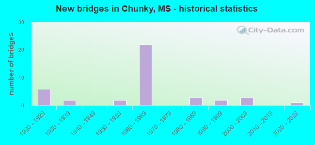
- New bridges - historical statistics
- 61920-1929
- 21930-1939
- 21950-1959
- 221960-1969
- 31980-1989
- 21990-1999
- 32000-2009
- 12020-2022
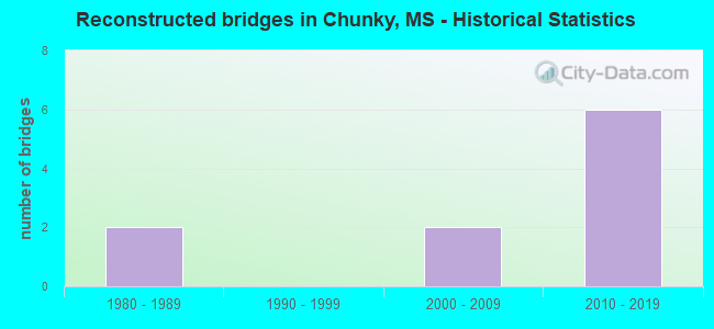
- Reconstructed bridges - Historical Statistics
- 21980-1989
- 01990-1999
- 22000-2009
- 62010-2019
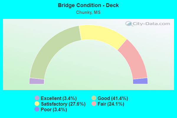
- Bridge Condition - Deck
- 3.4%Excellent
- 41.4%Good
- 27.6%Satisfactory
- 24.1%Fair
- 3.4%Poor
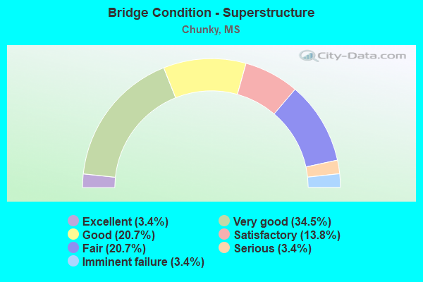
- Bridge Condition - Superstructure
- 3.4%Excellent
- 34.5%Very good
- 20.7%Good
- 13.8%Satisfactory
- 20.7%Fair
- 3.4%Serious
- 3.4%Imminent failure
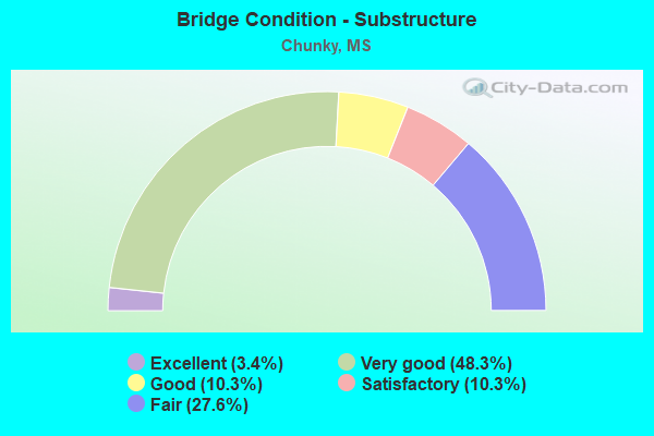
- Bridge Condition - Substructure
- 3.4%Excellent
- 48.3%Very good
- 10.3%Good
- 10.3%Satisfactory
- 27.6%Fair
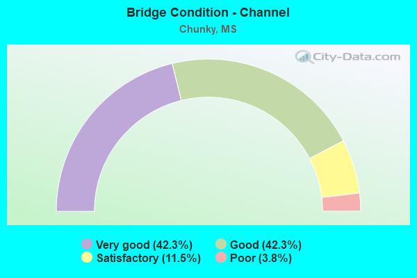
- Bridge Condition - Channel
- 42.3%Very good
- 42.3%Good
- 11.5%Satisfactory
- 3.8%Poor
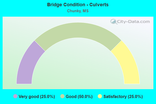
- Bridge Condition - Culverts
- 25.0%Very good
- 50.0%Good
- 25.0%Satisfactory
Find on map >> Show street view
Structure Number: 11000200381245A, Location: 1.7 MI E NEWTON CL (Lat: 32.345811, Lng: -88.885481), Route carried "on" structure: Interstate 20, Year Built: 1965, Year Reconstructed: 2010, Status: Open, Structure Length: 8.23m (27.00ft), Average Daily Traffic: 7,000 (year 2020), Truck Traffic: 41%, Average Future Daily Traffic: 8,000 (year 2040), Design Load: HS 20+Mod, Features Intersected: TALLAHATTA CREEK
Minimum Vertical Clearance: 30+ m (98+ ft), Kilometerpoint: 11.734, Lanes on structure: 2, Base Highway Network: Yes (Inventory Route: 2, Subroute: 1), Owner: State Highway Agency, Approaching Roadway Width: 12.8m (42.0ft), Material/Design: Prestressed concrete, Design/Construction: Stringer/Multi-beam, Number Of Spans In Main Unit: 1, Number Of Approach Spans: 5, Length of Maximum Span: 21.3m (69.9ft), Curb-To-Curb Width: 12.8m (42.0ft), Out-to-Out Width: 13.7m (44.9ft)
Condition: Deck: Good, Superstructure: Very good, Substructure: Very good, Channel: Very good, Operating Rating: 71.9 metric tons, Method Used To Determine Operating Rating: Load Factor (LF), Inventory Rating: 43.6 metric tons, Method Used To Determine Inventory Rating: Load Factor (LF), Structural Evaluation: Equal to present desirable criteria, Deck Geometry: Equal to present desirable criteria, Waterway Adequacy: Equal to present desirable criteria, Approach Roadway Alignment: Equal to present desirable criteria, Length Of Structure Improvement: 8.23m (27.00ft), Designated Inspection Frequency: Every 24 months, Inspection Date: April 2021, Bridge Improvement Cost: $200,000,000, Roadway Improvement Cost: $200,000,000, Total Project Cost: $400,000,000, Deck Structure Type: Concrete Cast-file-Place
Find on map >> Show street view
Structure Number: 11000200381245B, Location: 1.7 MI E NEWTON CL (Lat: 32.345350, Lng: -88.886317), Route carried "on" structure: Interstate 20, Year Built: 1965, Year Reconstructed: 2010, Status: Open, Structure Length: 8.23m (27.00ft), Average Daily Traffic: 7,000 (year 2020), Truck Traffic: 34%, Average Future Daily Traffic: 8,000 (year 2040), Design Load: HS 20+Mod, Features Intersected: TALLAHATTA CREEK
Minimum Vertical Clearance: 30+ m (98+ ft), Kilometerpoint: 2.691, Lanes on structure: 2, Base Highway Network: Yes (Inventory Route: 2, Subroute: 1), Owner: State Highway Agency, Approaching Roadway Width: 12.8m (42.0ft), Material/Design: Prestressed concrete, Design/Construction: Stringer/Multi-beam, Number Of Spans In Main Unit: 1, Number Of Approach Spans: 5, Length of Maximum Span: 21.3m (69.9ft), Curb-To-Curb Width: 12.8m (42.0ft), Out-to-Out Width: 13.7m (44.9ft)
Condition: Deck: Good, Superstructure: Very good, Substructure: Good, Channel: Very good, Operating Rating: 71.9 metric tons, Method Used To Determine Operating Rating: Load Factor (LF), Inventory Rating: 43.6 metric tons, Method Used To Determine Inventory Rating: Load Factor (LF), Structural Evaluation: Better than present minimum criteria, Deck Geometry: Equal to present desirable criteria, Waterway Adequacy: Equal to present desirable criteria, Approach Roadway Alignment: Equal to present desirable criteria, Length Of Structure Improvement: 8.23m (27.00ft), Designated Inspection Frequency: Every 24 months, Inspection Date: April 2021, Bridge Improvement Cost: $200,000,000, Roadway Improvement Cost: $200,000,000, Total Project Cost: $400,000,000, Deck Structure Type: Concrete Cast-file-Place
Find on map >> Show street view
Structure Number: 11000200511193A, Location: 4.0 MI E SR 503 (Lat: 32.343117, Lng: -88.974536), Route carried "on" structure: Interstate 20, Year Built: 1962, Year Reconstructed: 2013, Status: Open, Structure Length: 11.89m (39.01ft), Average Daily Traffic: 11,500 (year 2020), Truck Traffic: 40%, Average Future Daily Traffic: 13,500 (year 2040), Design Load: HS 20+Mod, Features Intersected: CHUNKY RIVER
Minimum Vertical Clearance: 30+ m (98+ ft), Kilometerpoint: 5.658, Lanes on structure: 2, Base Highway Network: Yes (Inventory Route: 2, Subroute: 1), Owner: State Highway Agency, Approaching Roadway Width: 12.8m (42.0ft), Material/Design: Prestressed concrete, Design/Construction: Stringer/Multi-beam, Number Of Spans In Main Unit: 1, Number Of Approach Spans: 8, Length of Maximum Span: 21.3m (69.9ft), Curb-To-Curb Width: 12.8m (42.0ft), Out-to-Out Width: 13.7m (44.9ft)
Condition: Deck: Satisfactory, Superstructure: Good, Substructure: Very good, Channel: Very good, Operating Rating: 71.9 metric tons, Method Used To Determine Operating Rating: Load Factor (LF), Inventory Rating: 43.6 metric tons, Method Used To Determine Inventory Rating: Load Factor (LF), Structural Evaluation: Better than present minimum criteria, Deck Geometry: Equal to present desirable criteria, Waterway Adequacy: Equal to present desirable criteria, Approach Roadway Alignment: Equal to present desirable criteria, Length Of Structure Improvement: 11.89m (39.01ft), Designated Inspection Frequency: Every 24 months, Inspection Date: Febuary 2021, Bridge Improvement Cost: $288,000,000, Roadway Improvement Cost: $200,000,000, Total Project Cost: $488,000,000, Deck Structure Type: Concrete Cast-file-Place
Find on map >> Show street view
Structure Number: 11000200511193B, Location: 4.0 MI E SR 503 (Lat: 32.342650, Lng: -88.975761), Route carried "on" structure: Interstate 20, Year Built: 1962, Year Reconstructed: 2013, Status: Open, Structure Length: 11.89m (39.01ft), Average Daily Traffic: 11,500 (year 2020), Truck Traffic: 40%, Average Future Daily Traffic: 13,500 (year 2040), Design Load: HS 20+Mod, Features Intersected: CHUNKY RIVER
Minimum Vertical Clearance: 30+ m (98+ ft), Kilometerpoint: 33.592, Lanes on structure: 2, Base Highway Network: Yes (Inventory Route: 2, Subroute: 1), Owner: State Highway Agency, Approaching Roadway Width: 12.8m (42.0ft), Material/Design: Prestressed concrete, Design/Construction: Stringer/Multi-beam, Number Of Spans In Main Unit: 1, Number Of Approach Spans: 8, Length of Maximum Span: 21.3m (69.9ft), Curb-To-Curb Width: 12.8m (42.0ft), Out-to-Out Width: 13.7m (44.9ft)
Condition: Deck: Satisfactory, Superstructure: Good, Substructure: Good, Channel: Very good, Operating Rating: 71.9 metric tons, Method Used To Determine Operating Rating: Load Factor (LF), Inventory Rating: 43.6 metric tons, Method Used To Determine Inventory Rating: Load Factor (LF), Structural Evaluation: Better than present minimum criteria, Deck Geometry: Equal to present desirable criteria, Waterway Adequacy: Equal to present desirable criteria, Approach Roadway Alignment: Equal to present desirable criteria, Length Of Structure Improvement: 11.89m (39.01ft), Designated Inspection Frequency: Every 24 months, Inspection Date: Febuary 2021, Bridge Improvement Cost: $288,000,000, Roadway Improvement Cost: $200,000,000, Total Project Cost: $488,000,000, Deck Structure Type: Concrete Cast-file-Place
Find on map >> Show street view
Structure Number: 11000200511197A, Location: 4.4 MI E SR 503 (Lat: 32.343542, Lng: -88.967767), Route carried "on" structure: Interstate 20, Year Built: 1962, Year Reconstructed: 2010, Status: Open, Structure Length: 4.72m (15.49ft), Average Daily Traffic: 11,500 (year 2020), Truck Traffic: 40%, Average Future Daily Traffic: 13,500 (year 2040), Design Load: HS 20+Mod, Features Intersected: MT. PLEASANT CHURCH ROAD
Minimum Vertical Clearance: 30+ m (98+ ft), Kilometerpoint: 5.018, Lanes on structure: 2, Lanes under structure: 2, Base Highway Network: Yes (Inventory Route: 2, Subroute: 1), Owner: State Highway Agency, Approaching Roadway Width: 12.8m (42.0ft), Material/Design: Prestressed concrete, Design/Construction: Stringer/Multi-beam, Number Of Spans In Main Unit: 3, Length of Maximum Span: 15.5m (50.9ft), Curb-To-Curb Width: 12.8m (42.0ft), Out-to-Out Width: 13.7m (44.9ft)
Condition: Deck: Good, Superstructure: Good, Substructure: Very good, Operating Rating: 74.6 metric tons, Method Used To Determine Operating Rating: Load Factor (LF), Inventory Rating: 36.6 metric tons, Method Used To Determine Inventory Rating: Load Factor (LF), Structural Evaluation: Better than present minimum criteria, Deck Geometry: Equal to present desirable criteria, Underclear: Meets minimum limits, Approach Roadway Alignment: Equal to present desirable criteria, Length Of Structure Improvement: 4.72m (15.49ft), Designated Inspection Frequency: Every 24 months, Inspection Date: Febuary 2021, Bridge Improvement Cost: $114,000,000, Roadway Improvement Cost: $200,000,000, Total Project Cost: $314,000,000, Deck Structure Type: Concrete Cast-file-Place
Find on map >> Show street view
Structure Number: 11000200511197B, Location: 4.4 MI E SR 503 (Lat: 32.343111, Lng: -88.968233), Route carried "on" structure: Interstate 20, Year Built: 1962, Year Reconstructed: 2010, Status: Open, Structure Length: 4.72m (15.49ft), Average Daily Traffic: 11,500 (year 2020), Truck Traffic: 40%, Average Future Daily Traffic: 13,500 (year 2040), Design Load: HS 20+Mod, Features Intersected: MT. PLEASANT CHURCH ROAD
Minimum Vertical Clearance: 30+ m (98+ ft), Kilometerpoint: 34.303, Lanes on structure: 2, Lanes under structure: 2, Base Highway Network: Yes (Inventory Route: 2, Subroute: 1), Owner: State Highway Agency, Approaching Roadway Width: 12.8m (42.0ft), Material/Design: Prestressed concrete, Design/Construction: Stringer/Multi-beam, Number Of Spans In Main Unit: 3, Length of Maximum Span: 15.5m (50.9ft), Curb-To-Curb Width: 12.8m (42.0ft), Out-to-Out Width: 13.7m (44.9ft)
Condition: Deck: Good, Superstructure: Very good, Substructure: Very good, Operating Rating: 74.6 metric tons, Method Used To Determine Operating Rating: Load Factor (LF), Inventory Rating: 36.6 metric tons, Method Used To Determine Inventory Rating: Load Factor (LF), Structural Evaluation: Equal to present desirable criteria, Deck Geometry: Equal to present desirable criteria, Underclear: Meets minimum limits, Approach Roadway Alignment: Equal to present desirable criteria, Length Of Structure Improvement: 4.72m (15.49ft), Designated Inspection Frequency: Every 24 months, Inspection Date: Febuary 2021, Bridge Improvement Cost: $114,000,000, Roadway Improvement Cost: $200,000,000, Total Project Cost: $314,000,000, Deck Structure Type: Concrete Cast-file-Place
Find on map >> Show street view
Structure Number: 11000200511212A, Location: 5.9 MI E SR 503 (Lat: 32.342811, Lng: -88.942100), Route carried "on" structure: Interstate 20, Year Built: 1962, Year Reconstructed: 2010, Status: Open, Structure Length: 4.72m (15.49ft), Average Daily Traffic: 11,500 (year 2020), Truck Traffic: 40%, Average Future Daily Traffic: 13,500 (year 2040), Design Load: HS 20+Mod, Features Intersected: TONACANA CREEK
Minimum Vertical Clearance: 30+ m (98+ ft), Kilometerpoint: 2.589, Lanes on structure: 2, Base Highway Network: Yes (Inventory Route: 2, Subroute: 1), Owner: State Highway Agency, Approaching Roadway Width: 12.8m (42.0ft), Material/Design: Prestressed concrete, Design/Construction: Stringer/Multi-beam, Number Of Spans In Main Unit: 3, Length of Maximum Span: 15.5m (50.9ft), Curb-To-Curb Width: 12.8m (42.0ft), Out-to-Out Width: 13.7m (44.9ft)
Condition: Deck: Satisfactory, Superstructure: Good, Substructure: Very good, Channel: Good, Operating Rating: 77.5 metric tons, Method Used To Determine Operating Rating: Load Factor (LF), Inventory Rating: 44.0 metric tons, Method Used To Determine Inventory Rating: Load Factor (LF), Structural Evaluation: Better than present minimum criteria, Deck Geometry: Equal to present desirable criteria, Waterway Adequacy: Equal to present desirable criteria, Approach Roadway Alignment: Equal to present desirable criteria, Length Of Structure Improvement: 4.72m (15.49ft), Designated Inspection Frequency: Every 24 months, Inspection Date: Febuary 2021, Bridge Improvement Cost: $114,000,000, Roadway Improvement Cost: $200,000,000, Total Project Cost: $314,000,000, Deck Structure Type: Concrete Cast-file-Place
Find on map >> Show street view
Structure Number: 11000200511212B, Location: 5.9 MI E SR 503 (Lat: 32.342189, Lng: -88.942686), Route carried "on" structure: Interstate 20, Year Built: 1962, Year Reconstructed: 2010, Status: Open, Structure Length: 4.72m (15.49ft), Average Daily Traffic: 11,500 (year 2020), Truck Traffic: 40%, Average Future Daily Traffic: 13,500 (year 2040), Design Load: HS 20+Mod, Features Intersected: TONACANA CREEK
Minimum Vertical Clearance: 30+ m (98+ ft), Kilometerpoint: 36.720, Lanes on structure: 2, Base Highway Network: Yes (Inventory Route: 2, Subroute: 1), Owner: State Highway Agency, Approaching Roadway Width: 12.8m (42.0ft), Material/Design: Prestressed concrete, Design/Construction: Stringer/Multi-beam, Number Of Spans In Main Unit: 3, Length of Maximum Span: 15.5m (50.9ft), Curb-To-Curb Width: 12.8m (42.0ft), Out-to-Out Width: 13.7m (44.9ft)
Condition: Deck: Satisfactory, Superstructure: Very good, Substructure: Good, Channel: Very good, Operating Rating: 77.5 metric tons, Method Used To Determine Operating Rating: Load Factor (LF), Inventory Rating: 44.0 metric tons, Method Used To Determine Inventory Rating: Load Factor (LF), Structural Evaluation: Better than present minimum criteria, Deck Geometry: Equal to present desirable criteria, Waterway Adequacy: Equal to present desirable criteria, Approach Roadway Alignment: Equal to present desirable criteria, Length Of Structure Improvement: 4.72m (15.49ft), Designated Inspection Frequency: Every 24 months, Inspection Date: Febuary 2021, Bridge Improvement Cost: $114,000,000, Roadway Improvement Cost: $200,000,000, Total Project Cost: $314,000,000, Deck Structure Type: Concrete Cast-file-Place
Find on map >> Show street view
Structure Number: 21000800381231, Location: 0.1 MI E NEWTON CL (Lat: 32.327597, Lng: -88.912442), Route carried "on" structure: US 80, Year Built: 1928, Status: Posted for load, Structure Length: 4.36m (14.30ft), Average Daily Traffic: 1,300 (year 2020), Truck Traffic: 12%, Average Future Daily Traffic: 1,300 (year 2040), Design Load: H 15, Features Intersected: SLOUGH
Minimum Vertical Clearance: 30+ m (98+ ft), Kilometerpoint: 0.217, Lanes on structure: 2, Owner: State Highway Agency, Approaching Roadway Width: 9.1m (29.9ft), Material/Design: Concrete, Design/Construction: Tee Beam, Number Of Spans In Main Unit: 5, Length of Maximum Span: 7.9m (25.9ft), Curb or Sidewalk Widths: Left: 0.3m (1.0ft), Right: 0.3m (1.0ft), Curb-To-Curb Width: 5.6m (18.4ft), Out-to-Out Width: 6.8m (22.3ft)
Condition: Deck: Fair, Superstructure: Fair, Substructure: Fair, Channel: Very good, Operating Rating: 34.4 metric tons, Method Used To Determine Operating Rating: Load Factor (LF), Inventory Rating: 20.6 metric tons, Method Used To Determine Inventory Rating: Load Factor (LF), Structural Evaluation: Somewhat better than minimum adequacy, Deck Geometry: High priority of replacement, Waterway Adequacy: Equal to present minimum criteria, Approach Roadway Alignment: Equal to present minimum criteria, Bridge Posting: Required (Relationship of Operating Rating to Maximum Legal Load: 0.1 - 9.9% below), Length Of Structure Improvement: 5.64m (18.50ft), Designated Inspection Frequency: Every 12 months, Inspection Date: April 2021, Bridge Improvement Cost: $499,000,000, Roadway Improvement Cost: $50,000,000, Total Project Cost: $999,999,000, Deck Structure Type: Concrete Cast-file-Place
Find on map >> Show street view
Structure Number: 21000800381233, Location: 0.3 MI E NEWTON CL (Lat: 32.326436, Lng: -88.909533), Route carried "on" structure: US 80, Year Built: 1929, Year Reconstructed: 1994, Status: Posted for load, Structure Length: 11.22m (36.81ft), Average Daily Traffic: 1,300 (year 2020), Truck Traffic: 12%, Average Future Daily Traffic: 1,300 (year 2040), Design Load: H 15, Features Intersected: CHUNKY RIVER
Minimum Vertical Clearance: 30+ m (98+ ft), Kilometerpoint: 0.525, Lanes on structure: 2, Owner: State Highway Agency, Approaching Roadway Width: 9.1m (29.9ft), Material/Design: Steel, Design/Construction: Stringer/Multi-beam, Number Of Spans In Main Unit: 1, Number Of Approach Spans: 9, Length of Maximum Span: 36.6m (120.1ft), Curb-To-Curb Width: 5.6m (18.4ft), Out-to-Out Width: 6.8m (22.3ft)
Condition: Deck: Fair, Superstructure: Fair, Substructure: Fair, Channel: Good, Operating Rating: 34.4 metric tons, Method Used To Determine Operating Rating: Load Factor (LF), Inventory Rating: 20.6 metric tons, Method Used To Determine Inventory Rating: Load Factor (LF), Structural Evaluation: Somewhat better than minimum adequacy, Deck Geometry: High priority of replacement, Waterway Adequacy: Equal to present minimum criteria, Approach Roadway Alignment: Meets minimum limits, Bridge Posting: Required (Relationship of Operating Rating to Maximum Legal Load: 0.1 - 9.9% below), Length Of Structure Improvement: 14.19m (46.56ft), Designated Inspection Frequency: Every 12 months, Inspection Date: April 2021, Bridge Improvement Cost: $999,999,000, Roadway Improvement Cost: $133,000,000, Total Project Cost: $999,999,000, Deck Structure Type: Concrete Cast-file-Place
Find on map >> Show street view
Structure Number: 21000800381235, Location: 0.5 MI E NEWTON CL (Lat: 32.324689, Lng: -88.906814), Route carried "on" structure: US 80, Year Built: 1928, Status: Open, Structure Length: 2.44m (8.01ft), Average Daily Traffic: 1,300 (year 2020), Truck Traffic: 12%, Average Future Daily Traffic: 1,300 (year 2040), Design Load: H 15, Features Intersected: SLOUGH
Minimum Vertical Clearance: 30+ m (98+ ft), Kilometerpoint: 0.856, Lanes on structure: 2, Owner: State Highway Agency, Approaching Roadway Width: 9.1m (29.9ft), Material/Design: Concrete, Design/Construction: Tee Beam, Number Of Spans In Main Unit: 3, Length of Maximum Span: 7.3m (24.0ft), Curb or Sidewalk Widths: Left: 0.2m (0.7ft), Right: 0.2m (0.7ft), Curb-To-Curb Width: 6.3m (20.7ft), Out-to-Out Width: 6.9m (22.6ft)
Condition: Deck: Fair, Superstructure: Fair, Substructure: Fair, Channel: Very good, Operating Rating: 35.6 metric tons, Method Used To Determine Operating Rating: Load Factor (LF), Inventory Rating: 21.5 metric tons, Method Used To Determine Inventory Rating: Load Factor (LF), Structural Evaluation: Somewhat better than minimum adequacy, Deck Geometry: High priority of replacement, Waterway Adequacy: Equal to present desirable criteria, Approach Roadway Alignment: Somewhat better than minimum adequacy, Length Of Structure Improvement: 4.02m (13.19ft), Designated Inspection Frequency: Every 24 months, Inspection Date: April 2021, Bridge Improvement Cost: $313,000,000, Roadway Improvement Cost: $31,000,000, Total Project Cost: $932,000,000, Deck Structure Type: Concrete Cast-file-Place
Find on map >> Show street view
Structure Number: 21000800381256, Location: 2.5 MI E NEWTON CL (Lat: 32.327103, Lng: -88.873125), Route carried "on" structure: US 80, Year Built: 1953, Status: Open, Structure Length: 9.75m (31.99ft), Average Daily Traffic: 2,000 (year 2020), Truck Traffic: 10%, Average Future Daily Traffic: 2,000 (year 2040), Design Load: HS 20, Features Intersected: TALLAHATTA CREEK
Minimum Vertical Clearance: 30+ m (98+ ft), Kilometerpoint: 4.146, Lanes on structure: 2, Owner: State Highway Agency, Approaching Roadway Width: 13.4m (44.0ft), Material/Design: Steel, Design/Construction: Stringer/Multi-beam, Number Of Spans In Main Unit: 1, Number Of Approach Spans: 6, Length of Maximum Span: 24.4m (80.1ft), Curb or Sidewalk Widths: Left: 0.6m (2.0ft), Right: 0.6m (2.0ft), Curb-To-Curb Width: 8.5m (27.9ft), Out-to-Out Width: 10.7m (35.1ft)
Condition: Deck: Good, Superstructure: Satisfactory, Substructure: Satisfactory, Channel: Very good, Operating Rating: 44.6 metric tons, Method Used To Determine Operating Rating: Load Factor (LF), Inventory Rating: 26.7 metric tons, Method Used To Determine Inventory Rating: Load Factor (LF), Structural Evaluation: Equal to present minimum criteria, Deck Geometry: Somewhat better than minimum adequacy, Waterway Adequacy: Equal to present desirable criteria, Approach Roadway Alignment: Equal to present desirable criteria, Length Of Structure Improvement: 10.67m (35.01ft), Designated Inspection Frequency: Every 24 months, Inspection Date: April 2021, Bridge Improvement Cost: $380,000,000, Roadway Improvement Cost: $130,000,000, Total Project Cost: $664,000,000, Deck Structure Type: Concrete Cast-file-Place
Find on map >> Show street view
Structure Number: 21000800511195, Location: 3.1 MI E SR 503 (Lat: 32.324650, Lng: -88.974222), Route carried "on" structure: US 80, Year Built: 1930, Status: Open, Structure Length: 3.96m (12.99ft), Average Daily Traffic: 1,300 (year 2020), Truck Traffic: 11%, Average Future Daily Traffic: 1,300 (year 2040), Design Load: H 15, Features Intersected: CHUNKY RELIEF
Minimum Vertical Clearance: 30+ m (98+ ft), Kilometerpoint: 34.086, Lanes on structure: 2, Owner: State Highway Agency, Approaching Roadway Width: 9.1m (29.9ft), Material/Design: Concrete, Design/Construction: Tee Beam, Number Of Spans In Main Unit: 4, Length of Maximum Span: 9.1m (29.9ft), Curb or Sidewalk Widths: Left: 0.2m (0.7ft), Right: 0.2m (0.7ft), Curb-To-Curb Width: 7.3m (24.0ft), Out-to-Out Width: 8.4m (27.6ft)
Condition: Deck: Fair, Superstructure: Fair, Substructure: Very good, Channel: Good, Operating Rating: 38.9 metric tons, Method Used To Determine Operating Rating: Load Factor (LF), Inventory Rating: 23.3 metric tons, Method Used To Determine Inventory Rating: Load Factor (LF), Structural Evaluation: Somewhat better than minimum adequacy, Deck Geometry: Meets minimum limits, Waterway Adequacy: High priority of corrective action, Approach Roadway Alignment: Equal to present desirable criteria, Length Of Structure Improvement: 5.13m (16.83ft), Designated Inspection Frequency: Every 24 months, Inspection Date: Febuary 2021, Bridge Improvement Cost: $436,000,000, Roadway Improvement Cost: $44,000,000, Total Project Cost: $999,999,000, Deck Structure Type: Concrete Cast-file-Place
Find on map >> Show street view
Structure Number: 21000800511198, Location: 3.4 MI E SR 503 (Lat: 32.325464, Lng: -88.968386), Route carried "on" structure: US 80, Year Built: 1930, Status: Open, Structure Length: 0.70m (2.30ft), Average Daily Traffic: 1,300 (year 2020), Truck Traffic: 11%, Average Future Daily Traffic: 1,300 (year 2040), Design Load: H 15, Features Intersected: CHUNKY RELIEF
Minimum Vertical Clearance: 30+ m (98+ ft), Kilometerpoint: 34.643, Lanes on structure: 2, Owner: State Highway Agency, Approaching Roadway Width: 9.1m (29.9ft), Material/Design: Concrete, Design/Construction: Culvert, Number Of Spans In Main Unit: 2, Length of Maximum Span: 3.0m (9.8ft)
Condition: Channel: Very good, Culverts: Very good, Operating Rating: 59.6 metric tons, Method Used To Determine Operating Rating: Load Factor (LF), Inventory Rating: 35.8 metric tons, Method Used To Determine Inventory Rating: Load Factor (LF), Structural Evaluation: Equal to present desirable criteria, Waterway Adequacy: High priority of corrective action, Approach Roadway Alignment: Better than present minimum criteria, Designated Inspection Frequency: Every 24 months, Inspection Date: Febuary 2021
Find on map >> Show street view
Structure Number: 21000800511214, Location: 5.1 MI E SR 503 (Lat: 32.325950, Lng: -88.940483), Route carried "on" structure: US 80, Year Built: 1929, Status: Open, Structure Length: 2.99m (9.81ft), Average Daily Traffic: 1,300 (year 2020), Truck Traffic: 11%, Average Future Daily Traffic: 1,300 (year 2040), Design Load: H 15, Features Intersected: TONACANA CREEK
Minimum Vertical Clearance: 30+ m (98+ ft), Kilometerpoint: 37.272, Lanes on structure: 2, Owner: State Highway Agency, Approaching Roadway Width: 9.1m (29.9ft), Material/Design: Concrete, Design/Construction: Tee Beam, Number Of Spans In Main Unit: 3, Length of Maximum Span: 9.1m (29.9ft), Curb or Sidewalk Widths: Left: 0.2m (0.7ft), Right: 0.2m (0.7ft), Curb-To-Curb Width: 6.1m (20.0ft), Out-to-Out Width: 7.2m (23.6ft)
Condition: Deck: Fair, Superstructure: Fair, Substructure: Fair, Channel: Very good, Operating Rating: 36.5 metric tons, Method Used To Determine Operating Rating: Load Factor (LF), Inventory Rating: 21.9 metric tons, Method Used To Determine Inventory Rating: Load Factor (LF), Structural Evaluation: Somewhat better than minimum adequacy, Deck Geometry: High priority of replacement, Waterway Adequacy: High priority of corrective action, Approach Roadway Alignment: Equal to present desirable criteria, Length Of Structure Improvement: 3.99m (13.09ft), Designated Inspection Frequency: Every 24 months, Inspection Date: Febuary 2021, Bridge Improvement Cost: $309,000,000, Roadway Improvement Cost: $31,000,000, Total Project Cost: $921,000,000, Deck Structure Type: Concrete Cast-file-Place
Find on map >> Show street view
Structure Number: 21000800511225, Location: 6.2 MI E SR 503 (Lat: 32.326389, Lng: -88.922033), Route carried "on" structure: US 80, Year Built: 1929, Year Reconstructed: 1992, Status: Open, Structure Length: 16.28m (53.41ft), Average Daily Traffic: 1,100 (year 2020), Truck Traffic: 11%, Average Future Daily Traffic: 1,100 (year 2040), Design Load: H 15, Features Intersected: CHUNKY RIVER
Minimum Vertical Clearance: 30+ m (98+ ft), Kilometerpoint: 39.015, Lanes on structure: 2, Owner: State Highway Agency, Approaching Roadway Width: 9.1m (29.9ft), Material/Design: Steel, Design/Construction: Stringer/Multi-beam, Number Of Spans In Main Unit: 1, Number Of Approach Spans: 13, Length of Maximum Span: 36.6m (120.1ft), Curb or Sidewalk Widths: Left: 0.2m (0.7ft), Right: 0.2m (0.7ft), Curb-To-Curb Width: 6.1m (20.0ft), Out-to-Out Width: 7.2m (23.6ft)
Condition: Deck: Fair, Superstructure: Serious, Substructure: Satisfactory, Channel: Very good, Operating Rating: 36.5 metric tons, Method Used To Determine Operating Rating: Load Factor (LF), Inventory Rating: 21.9 metric tons, Method Used To Determine Inventory Rating: Load Factor (LF), Structural Evaluation: High priority of corrective action, Deck Geometry: High priority of replacement, Waterway Adequacy: Better than present minimum criteria, Approach Roadway Alignment: Meets minimum limits, Length Of Structure Improvement: 20.23m (66.37ft), Designated Inspection Frequency: Every 24 months, Inspection Date: March 2021, Bridge Improvement Cost: $999,999,000, Roadway Improvement Cost: $194,000,000, Total Project Cost: $999,999,000, Deck Structure Type: Concrete Cast-file-Place
Find on map >> Show street view
Structure Number: 41000200381239, Location: 1.0 MI E NEWTON CL (Lat: 32.344106, Lng: -88.897197), Route carried "on" structure: County highway , Year Built: 1965, Status: Open, Structure Length: 8.11m (26.61ft), Average Daily Traffic: 300 (year 2020), Truck Traffic: 8%, Average Future Daily Traffic: 300 (year 2040), Design Load: HS 15, Features Intersected: I 20, Facility Carried by Structure: PEAVY ROAD
Minimum Vertical Clearance: 30+ m (98+ ft), Kilometerpoint: 2.248, Lanes on structure: 2, Lanes under structure: 4, Owner: State Highway Agency, Approaching Roadway Width: 8.5m (27.9ft), Material/Design: Concrete continuous, Design/Construction: Box Beam or Girders - Single/Spread, Number Of Spans In Main Unit: 2, Number Of Approach Spans: 2, Length of Maximum Span: 22.9m (75.1ft), Curb or Sidewalk Widths: Left: 0.5m (1.6ft), Right: 0.5m (1.6ft), Curb-To-Curb Width: 7.3m (24.0ft), Out-to-Out Width: 8.8m (28.9ft)
Condition: Deck: Good, Superstructure: Good, Substructure: Very good, Operating Rating: 59.0 metric tons, Method Used To Determine Operating Rating: Load Factor (LF), Inventory Rating: 35.3 metric tons, Method Used To Determine Inventory Rating: Load Factor (LF), Structural Evaluation: Better than present minimum criteria, Deck Geometry: Somewhat better than minimum adequacy, Underclear: Somewhat better than minimum adequacy, Approach Roadway Alignment: Better than present minimum criteria, Designated Inspection Frequency: Every 24 months, Inspection Date: April 2021, Deck Structure Type: Concrete Cast-file-Place
Find on map >> Show street view
Structure Number: 4100020038125, Location: 2.1 MI E NEWTON CL (Lat: 32.345681, Lng: -88.879161), Route carried "on" structure: County highway , Year Built: 1965, Status: Open, Structure Length: 8.11m (26.61ft), Average Daily Traffic: 90 (year 2020), Truck Traffic: 11%, Average Future Daily Traffic: 90 (year 2040), Design Load: HS 15, Features Intersected: I 20, Facility Carried by Structure: SUQUALENA MEEHAN
Minimum Vertical Clearance: 30+ m (98+ ft), Kilometerpoint: 2.477, Lanes on structure: 2, Lanes under structure: 4, Owner: State Highway Agency, Approaching Roadway Width: 9.1m (29.9ft), Material/Design: Concrete continuous, Design/Construction: Box Beam or Girders - Single/Spread, Number Of Spans In Main Unit: 2, Number Of Approach Spans: 2, Length of Maximum Span: 22.9m (75.1ft), Curb or Sidewalk Widths: Left: 0.5m (1.6ft), Right: 0.5m (1.6ft), Curb-To-Curb Width: 7.3m (24.0ft), Out-to-Out Width: 8.8m (28.9ft)
Condition: Deck: Good, Superstructure: Good, Substructure: Very good, Operating Rating: 59.0 metric tons, Method Used To Determine Operating Rating: Load Factor (LF), Inventory Rating: 35.3 metric tons, Method Used To Determine Inventory Rating: Load Factor (LF), Structural Evaluation: Better than present minimum criteria, Deck Geometry: Equal to present minimum criteria, Underclear: Somewhat better than minimum adequacy, Approach Roadway Alignment: Equal to present desirable criteria, Designated Inspection Frequency: Every 24 months, Inspection Date: April 2021, Deck Structure Type: Concrete Cast-file-Place
Find on map >> Show street view
Structure Number: 41000200511208A, Location: 5.5 MI E SR 503 (Lat: 32.342697, Lng: -88.949433), Route carried "on" structure: County highway , Year Built: 1962, Status: Open, Structure Length: 4.94m (16.21ft), Average Daily Traffic: 80 (year 2020), Truck Traffic: 8%, Average Future Daily Traffic: 80 (year 2040), Design Load: HS 15, Features Intersected: I 20, Facility Carried by Structure: RIDGE ROAD
Minimum Vertical Clearance: 30+ m (98+ ft), Kilometerpoint: 1.897, Lanes on structure: 2, Lanes under structure: 2, Owner: State Highway Agency, Approaching Roadway Width: 9.1m (29.9ft), Skew: 1 degrees, Material/Design: Prestressed concrete, Design/Construction: Stringer/Multi-beam, Number Of Spans In Main Unit: 3, Length of Maximum Span: 20.4m (66.9ft), Curb or Sidewalk Widths: Left: 0.6m (2.0ft), Right: 0.6m (2.0ft), Curb-To-Curb Width: 7.3m (24.0ft), Out-to-Out Width: 9.1m (29.9ft)
Condition: Deck: Good, Superstructure: Very good, Substructure: Very good, Operating Rating: 89.0 metric tons, Method Used To Determine Operating Rating: Load Factor (LF), Inventory Rating: 57.2 metric tons, Method Used To Determine Inventory Rating: Load Factor (LF), Structural Evaluation: Equal to present desirable criteria, Deck Geometry: Equal to present minimum criteria, Underclear: Somewhat better than minimum adequacy, Approach Roadway Alignment: Equal to present desirable criteria, Designated Inspection Frequency: Every 24 months, Inspection Date: Febuary 2021, Deck Structure Type: Concrete Cast-file-Place
Find on map >> Show street view
Structure Number: 41000200511208B, Location: 5.5 MI E SR 503 (Lat: 32.343425, Lng: -88.949544), Route carried "on" structure: County highway , Year Built: 1962, Status: Open, Structure Length: 4.94m (16.21ft), Average Daily Traffic: 80 (year 2020), Truck Traffic: 8%, Average Future Daily Traffic: 80 (year 2040), Design Load: HS 15, Features Intersected: I 20, Facility Carried by Structure: RIDGE ROAD
Minimum Vertical Clearance: 30+ m (98+ ft), Kilometerpoint: 1.979, Lanes on structure: 2, Lanes under structure: 2, Owner: State Highway Agency, Approaching Roadway Width: 9.1m (29.9ft), Skew: 1 degrees, Material/Design: Prestressed concrete, Design/Construction: Stringer/Multi-beam, Number Of Spans In Main Unit: 3, Length of Maximum Span: 20.4m (66.9ft), Curb or Sidewalk Widths: Left: 0.6m (2.0ft), Right: 0.6m (2.0ft), Curb-To-Curb Width: 7.3m (24.0ft), Out-to-Out Width: 9.1m (29.9ft)
Condition: Deck: Good, Superstructure: Very good, Substructure: Very good, Operating Rating: 89.0 metric tons, Method Used To Determine Operating Rating: Load Factor (LF), Inventory Rating: 57.2 metric tons, Method Used To Determine Inventory Rating: Load Factor (LF), Structural Evaluation: Equal to present desirable criteria, Deck Geometry: Equal to present minimum criteria, Underclear: Somewhat better than minimum adequacy, Approach Roadway Alignment: Equal to present desirable criteria, Length Of Structure Improvement: 4.94m (16.21ft), Designated Inspection Frequency: Every 24 months, Inspection Date: Febuary 2021, Bridge Improvement Cost: $9,000,000, Roadway Improvement Cost: $200,000,000, Total Project Cost: $242,000,000, Deck Structure Type: Concrete Cast-file-Place
Find on map >> Show street view
Structure Number: 41000200511219, Location: SR 889 OVER I 20 (Lat: 32.341889, Lng: -88.931211), Route carried "on" structure: State highway 889, Year Built: 1965, Status: Open, Structure Length: 7.99m (26.21ft), Average Daily Traffic: 1,200 (year 2020), Truck Traffic: 5%, Average Future Daily Traffic: 1,200 (year 2040), Design Load: HS 20, Features Intersected: I 20
Minimum Vertical Clearance: 30+ m (98+ ft), Kilometerpoint: 1.761, Lanes on structure: 2, Lanes under structure: 4, Owner: State Highway Agency, Approaching Roadway Width: 10.4m (34.1ft), Material/Design: Prestressed concrete, Design/Construction: Stringer/Multi-beam, Number Of Spans In Main Unit: 4, Length of Maximum Span: 21.3m (69.9ft), Curb or Sidewalk Widths: Left: 0.5m (1.6ft), Right: 0.5m (1.6ft), Curb-To-Curb Width: 8.5m (27.9ft), Out-to-Out Width: 10.0m (32.8ft)
Condition: Deck: Good, Superstructure: Very good, Substructure: Very good, Inventory Rating: 68.0 metric tons, Method Used To Determine Inventory Rating: Load Factor (LF), Structural Evaluation: Equal to present desirable criteria, Deck Geometry: Somewhat better than minimum adequacy, Underclear: Meets minimum limits, Approach Roadway Alignment: Equal to present desirable criteria, Designated Inspection Frequency: Every 24 months, Inspection Date: Febuary 2021, Deck Structure Type: Concrete Cast-file-Place
Find on map >> Show street view
Structure Number: SA3800000000019, Location: SEC 5 T 5N R14E (Lat: 32.309278, Lng: -88.892025), Route carried "on" structure: County highway 340, Year Built: 1983, Status: Open, Structure Length: 6.10m (20.01ft), Average Daily Traffic: 370 (year 2019), Truck Traffic: 15%, Average Future Daily Traffic: 550 (year 2041), Design Load: HS 15, Features Intersected: CHUNKY RIVER RELIEF, Facility Carried by Structure: POINT WANITA LAKE
Minimum Vertical Clearance: 30+ m (98+ ft), Kilometerpoint: 10.782, Lanes on structure: 2, Owner: County Highway Agency, Approaching Roadway Width: 9.1m (29.9ft), Material/Design: Prestressed concrete, Design/Construction: Stringer/Multi-beam, Number Of Spans In Main Unit: 5, Length of Maximum Span: 12.2m (40.0ft), Curb-To-Curb Width: 7.9m (25.9ft), Out-to-Out Width: 8.8m (28.9ft)
Condition: Deck: Satisfactory, Superstructure: Very good, Substructure: Very good, Channel: Good, Operating Rating: 48.9 metric tons, Method Used To Determine Operating Rating: Load and Resistance Factor Rating (LRFR) rating reported by rating factor(RF) method using HL-93 loadings, Inventory Rating: 37.3 metric tons, Method Used To Determine Inventory Rating: Load and Resistance Factor Rating (LRFR) rating reported by rating factor(RF) method using HL-93 loadings, Structural Evaluation: Equal to present desirable criteria, Deck Geometry: Somewhat better than minimum adequacy, Waterway Adequacy: Equal to present desirable criteria, Approach Roadway Alignment: Equal to present minimum criteria, Length Of Structure Improvement: 7.32m (24.02ft), Designated Inspection Frequency: Every 24 months, Inspection Date: November 2020, Bridge Improvement Cost: $960,000, Roadway Improvement Cost: $150,000, Total Project Cost: $1,110,000 ( Estimate for 2021), Deck Structure Type: Concrete Cast-file-Place, Wearing Surface/Protective System: Wearing Surface: Monolithic Concrete
Find on map >> Show street view
Structure Number: SA380000000002, Location: SEC 5 T 5N R14E B (Lat: 32.310675, Lng: -88.890669), Route carried "on" structure: County highway 340, Year Built: 1957, Status: Posted for load, Structure Length: 9.15m (30.02ft), Average Daily Traffic: 400 (year 2018), Truck Traffic: 8%, Average Future Daily Traffic: 600 (year 2040), Design Load: H 15, Features Intersected: CHUNKY RIVER, Facility Carried by Structure: POINT-WANITA RD
Minimum Vertical Clearance: 30+ m (98+ ft), Kilometerpoint: 10.943, Lanes on structure: 2, Owner: County Highway Agency, Approaching Roadway Width: 8.5m (27.9ft), Material/Design: Steel, Design/Construction: Stringer/Multi-beam, Number Of Spans In Main Unit: 1, Number Of Approach Spans: 7, Length of Maximum Span: 30.5m (100.1ft), Curb or Sidewalk Widths: Left: 0.3m (1.0ft), Right: 0.3m (1.0ft), Curb-To-Curb Width: 6.7m (22.0ft), Out-to-Out Width: 7.4m (24.3ft)
Condition: Deck: Fair, Superstructure: Satisfactory, Substructure: Fair, Channel: Satisfactory, Operating Rating: 23.5 metric tons, Method Used To Determine Operating Rating: Load Factor (LF), Inventory Rating: 14.1 metric tons, Method Used To Determine Inventory Rating: Load Factor (LF), Structural Evaluation: Meets minimum limits, Deck Geometry: Meets minimum limits, Waterway Adequacy: Better than present minimum criteria, Approach Roadway Alignment: Equal to present minimum criteria, Bridge Posting: Required (Relationship of Operating Rating to Maximum Legal Load: 30.0 - 39.9% below), Length Of Structure Improvement: 10.36m (33.99ft), Designated Inspection Frequency: Every 24 months, Inspection Date: January 2021, Bridge Improvement Cost: $1,360,000, Roadway Improvement Cost: $200,000, Total Project Cost: $1,560,000 ( Estimate for 2020), Deck Structure Type: Concrete Cast-file-Place, Wearing Surface/Protective System: Wearing Surface: Monolithic Concrete
Find on map >> Show street view
Structure Number: SA3800000000063, Location: SEC 7 T 6N R14E (Lat: 32.370222, Lng: -88.904028), Route carried "on" structure: County highway 1185, Year Built: 2009, Status: Open, Structure Length: 4.27m (14.01ft), Average Daily Traffic: 100 (year 2016), Truck Traffic: 10%, Average Future Daily Traffic: 150 (year 2040), Design Load: HS 20, Features Intersected: TALLAHATTA CREEK, Facility Carried by Structure: PEAVY RD NORT
Minimum Vertical Clearance: 30+ m (98+ ft), Kilometerpoint: 7.081, Lanes on structure: 2, Owner: County Highway Agency, Approaching Roadway Width: 6.7m (22.0ft), Material/Design: Prestressed concrete, Design/Construction: Stringer/Multi-beam, Number Of Spans In Main Unit: 3, Length of Maximum Span: 18.3m (60.0ft), Curb-To-Curb Width: 7.9m (25.9ft), Out-to-Out Width: 8.8m (28.9ft)
Condition: Deck: Good, Superstructure: Very good, Substructure: Very good, Channel: Good, Operating Rating: 48.9 metric tons, Method Used To Determine Operating Rating: Load and Resistance Factor Rating (LRFR) rating reported by rating factor(RF) method using HL-93 loadings, Inventory Rating: 37.3 metric tons, Method Used To Determine Inventory Rating: Load and Resistance Factor Rating (LRFR) rating reported by rating factor(RF) method using HL-93 loadings, Structural Evaluation: Equal to present desirable criteria, Deck Geometry: Equal to present minimum criteria, Waterway Adequacy: Superior to present desirable criteria, Approach Roadway Alignment: Equal to present desirable criteria, Length Of Structure Improvement: 4.88m (16.01ft), Designated Inspection Frequency: Every 24 months, Inspection Date: November 2020, Bridge Improvement Cost: $390,000, Roadway Improvement Cost: $150,000, Total Project Cost: $540,000 ( Estimate for 2020), Deck Structure Type: Concrete Cast-file-Place, Wearing Surface/Protective System: Wearing Surface: Monolithic Concrete
Find on map >> Show street view
Structure Number: SA3800000000064, Location: SEC 7 T 6N R14E (Lat: 32.371611, Lng: -88.901889), Route carried "on" structure: County highway 1523, Year Built: 2009, Status: Open, Structure Length: 1.31m (4.30ft), Average Daily Traffic: 120 (year 2016), Truck Traffic: 8%, Average Future Daily Traffic: 180 (year 2040), Design Load: HS 20, Features Intersected: BOGUE FLOWER CREEK, Facility Carried by Structure: BOGUE STATINEAU RD
Minimum Vertical Clearance: 30+ m (98+ ft), Kilometerpoint: 1.609, Lanes on structure: 2, Owner: County Highway Agency, Approaching Roadway Width: 6.1m (20.0ft), Material/Design: Concrete, Design/Construction: Culvert, Number Of Spans In Main Unit: 2, Length of Maximum Span: 6.1m (20.0ft)
Condition: Channel: Good, Culverts: Good, Operating Rating: 64.8 metric tons, Method Used To Determine Operating Rating: Load Factor (LF) rating reported by rating factor (RF) method using MS18 loading, Inventory Rating: 38.9 metric tons, Method Used To Determine Inventory Rating: Load Factor (LF) rating reported by rating factor (RF) method using MS18 loading, Structural Evaluation: Better than present minimum criteria, Waterway Adequacy: Superior to present desirable criteria, Approach Roadway Alignment: Equal to present desirable criteria, Length Of Structure Improvement: 1.53m (5.02ft), Designated Inspection Frequency: Every 24 months, Inspection Date: November 2020, Bridge Improvement Cost: $250,000, Roadway Improvement Cost: $150,000, Total Project Cost: $400,000 ( Estimate for 2020)
Find on map >> Show street view
Structure Number: SA3800000000067, Location: SEC 17 T 6N R14E B (Lat: 32.361750, Lng: -88.887250), Route carried "on" structure: County highway 1523, Year Built: 1967, Status: Open, Structure Length: 1.74m (5.71ft), Average Daily Traffic: 180 (year 2021), Truck Traffic: 8%, Average Future Daily Traffic: 270 (year 2041), Design Load: H 15, Features Intersected: STATINEA CREEK, Facility Carried by Structure: SUQUALENA-MEEHAN
Minimum Vertical Clearance: 30+ m (98+ ft), Kilometerpoint: 4.345, Lanes on structure: 2, Owner: County Highway Agency, Approaching Roadway Width: 7.1m (23.3ft), Material/Design: Concrete, Design/Construction: Channel Beam, Number Of Spans In Main Unit: 3, Length of Maximum Span: 5.8m (19.0ft), Curb or Sidewalk Widths: Left: 0.2m (0.7ft), Right: 0.2m (0.7ft), Curb-To-Curb Width: 7.1m (23.3ft), Out-to-Out Width: 7.5m (24.6ft)
Condition: Deck: Good, Superstructure: Satisfactory, Substructure: Fair, Channel: Good, Operating Rating: 35.4 metric tons, Method Used To Determine Operating Rating: Load Factor (LF), Inventory Rating: 21.2 metric tons, Method Used To Determine Inventory Rating: Load Factor (LF), Structural Evaluation: Somewhat better than minimum adequacy, Deck Geometry: Meets minimum limits, Waterway Adequacy: Equal to present minimum criteria, Approach Roadway Alignment: Better than present minimum criteria, Length Of Structure Improvement: 2.10m (6.89ft), Designated Inspection Frequency: Every 12 months, Inspection Date: October 2021, Bridge Improvement Cost: $320,000, Roadway Improvement Cost: $60,000, Total Project Cost: $380,000 ( Estimate for 2021), Deck Structure Type: Concrete Precast Panels, Wearing Surface/Protective System: Wearing Surface: Bituminous
Find on map >> Show street view
Structure Number: SA3800000000072, Location: SEC 32 T 6N R14E B (Lat: 32.313889, Lng: -88.889167), Route carried "on" structure: County highway 340, Year Built: 1983, Status: Open, Structure Length: 6.10m (20.01ft), Average Daily Traffic: 400 (year 2017), Truck Traffic: 10%, Average Future Daily Traffic: 600 (year 2040), Design Load: HS 15, Features Intersected: CHUNKY RIVER RELIEF, Facility Carried by Structure: POINT-WANITA RD
Minimum Vertical Clearance: 30+ m (98+ ft), Kilometerpoint: 11.426, Lanes on structure: 2, Owner: County Highway Agency, Approaching Roadway Width: 9.1m (29.9ft), Material/Design: Prestressed concrete, Design/Construction: Stringer/Multi-beam, Number Of Spans In Main Unit: 5, Length of Maximum Span: 12.2m (40.0ft), Curb-To-Curb Width: 7.9m (25.9ft), Out-to-Out Width: 8.8m (28.9ft)
Condition: Deck: Satisfactory, Superstructure: Very good, Substructure: Very good, Channel: Good, Operating Rating: 56.4 metric tons, Method Used To Determine Operating Rating: Load and Resistance Factor Rating (LRFR) rating reported by rating factor(RF) method using HL-93 loadings, Inventory Rating: 43.4 metric tons, Method Used To Determine Inventory Rating: Load and Resistance Factor Rating (LRFR) rating reported by rating factor(RF) method using HL-93 loadings, Structural Evaluation: Equal to present desirable criteria, Deck Geometry: Somewhat better than minimum adequacy, Waterway Adequacy: Better than present minimum criteria, Approach Roadway Alignment: Equal to present desirable criteria, Length Of Structure Improvement: 7.33m (24.05ft), Designated Inspection Frequency: Every 24 months, Inspection Date: November 2020, Bridge Improvement Cost: $960,000, Roadway Improvement Cost: $150,000, Total Project Cost: $1,110,000 ( Estimate for 2020), Deck Structure Type: Concrete Cast-file-Place, Wearing Surface/Protective System: Wearing Surface: Monolithic Concrete
Find on map >> Show street view
Structure Number: SA380000000A038, Location: SEC 15 T 5N R16E (Lat: 32.271364, Lng: -88.925639), Route carried "on" structure: County highway 936, Year Built: 2021, Status: Open, Structure Length: 3.66m (12.01ft), Average Daily Traffic: 60 (year 2020), Truck Traffic: 1%, Average Future Daily Traffic: 90 (year 2040), Design Load: HS 20, Features Intersected: LONG CREEK, Facility Carried by Structure: PURVIS ROAD
Minimum Vertical Clearance: 30+ m (98+ ft), Kilometerpoint: 1.448, Lanes on structure: 2, Owner: County Highway Agency, Approaching Roadway Width: 6.4m (21.0ft), Material/Design: Prestressed concrete, Design/Construction: Stringer/Multi-beam, Number Of Spans In Main Unit: 3, Length of Maximum Span: 12.2m (40.0ft), Curb or Sidewalk Widths: Left: 0.5m (1.6ft), Right: 0.5m (1.6ft), Curb-To-Curb Width: 8.5m (27.9ft), Out-to-Out Width: 9.7m (31.8ft)
Condition: Deck: Excellent, Superstructure: Excellent, Substructure: Excellent, Channel: Good, Operating Rating: 56.4 metric tons, Method Used To Determine Operating Rating: Load and Resistance Factor Rating (LRFR) rating reported by rating factor(RF) method using HL-93 loadings, Inventory Rating: 43.4 metric tons, Method Used To Determine Inventory Rating: Load and Resistance Factor Rating (LRFR) rating reported by rating factor(RF) method using HL-93 loadings, Structural Evaluation: Superior to present desirable criteria, Deck Geometry: Better than present minimum criteria, Waterway Adequacy: Equal to present desirable criteria, Approach Roadway Alignment: Equal to present minimum criteria, Length Of Structure Improvement: 4.27m (14.01ft), Designated Inspection Frequency: Every 24 months, Inspection Date: March 2021, Bridge Improvement Cost: $560,000, Roadway Improvement Cost: $150,000, Total Project Cost: $710,000 ( Estimate for 2021), Deck Structure Type: Concrete Cast-file-Place
Find on map >> Show street view
Structure Number: SA5100000000062, Location: SEC 14 T 6N R13E B (Lat: 32.355222, Lng: -88.947111), Route carried "on" structure: County highway 31, Year Built: 1990, Status: Open, Structure Length: 1.46m (4.79ft), Average Daily Traffic: 100 (year 2020), Truck Traffic: 8%, Average Future Daily Traffic: 150 (year 2040), Design Load: HS 20, Features Intersected: TONACANA CREEK, Facility Carried by Structure: LAZY ACRES ROAD
Minimum Vertical Clearance: 30+ m (98+ ft), Kilometerpoint: 1.931, Lanes on structure: 2, Owner: County Highway Agency, Approaching Roadway Width: 9.1m (29.9ft), Skew: 4 degrees, Material/Design: Concrete, Design/Construction: Culvert, Number Of Spans In Main Unit: 2, Length of Maximum Span: 4.9m (16.1ft)
Condition: Channel: Satisfactory, Culverts: Satisfactory, Operating Rating: 90.2 metric tons, Method Used To Determine Operating Rating: Load Factor (LF), Inventory Rating: 54.3 metric tons, Method Used To Determine Inventory Rating: Load Factor (LF), Structural Evaluation: Equal to present minimum criteria, Waterway Adequacy: Equal to present desirable criteria, Approach Roadway Alignment: Equal to present desirable criteria, Designated Inspection Frequency: Every 24 months, Inspection Date: October 2020
Find on map >> Show street view
Structure Number: SA5100000000064, Location: SEC 26 T 6N R13E (Lat: 32.330278, Lng: -88.941972), Route carried "on" structure: County highway 33, Year Built: 1980, Status: Posted for load, Structure Length: 1.74m (5.71ft), Average Daily Traffic: 120 (year 2021), Truck Traffic: 8%, Average Future Daily Traffic: 180 (year 2041), Design Load: H 15, Features Intersected: TONACANA CREEK, Facility Carried by Structure: TRUELIGHT ROAD
Minimum Vertical Clearance: 30+ m (98+ ft), Kilometerpoint: 0.965, Lanes on structure: 2, Owner: County Highway Agency, Approaching Roadway Width: 6.1m (20.0ft), Material/Design: Concrete, Design/Construction: Channel Beam, Number Of Spans In Main Unit: 3, Length of Maximum Span: 5.8m (19.0ft), Curb or Sidewalk Widths: Left: 0.2m (0.7ft), Right: 0.2m (0.7ft), Curb-To-Curb Width: 7.1m (23.3ft), Out-to-Out Width: 7.5m (24.6ft)
Condition: Deck: Satisfactory, Superstructure: Satisfactory, Substructure: Fair, Channel: Poor, Operating Rating: 59.5 metric tons, Method Used To Determine Operating Rating: Load Factor (LF), Inventory Rating: 35.6 metric tons, Method Used To Determine Inventory Rating: Load Factor (LF), Structural Evaluation: Somewhat better than minimum adequacy, Deck Geometry: Meets minimum limits, Waterway Adequacy: Equal to present minimum criteria, Approach Roadway Alignment: Equal to present desirable criteria, Length Of Structure Improvement: 2.83m (9.28ft), Designated Inspection Frequency: Every 12 months, Inspection Date: October 2021, Bridge Improvement Cost: $169,000, Roadway Improvement Cost: $17,000, Total Project Cost: $208,000 ( Estimate for 2021), Deck Structure Type: Concrete Precast Panels, Wearing Surface/Protective System: Wearing Surface: Gravel
Find on map >> Show street view
Structure Number: SA5100000000067, Location: SEC 33 T 6N R13E (Lat: 32.312886, Lng: -88.974258), Route carried "on" structure: County highway 9, Year Built: 1992, Status: Posted for load, Structure Length: 2.72m (8.92ft), Average Daily Traffic: 64 (year 2018), Average Future Daily Traffic: 96 (year 2038), Design Load: H 15, Features Intersected: POTTERCHITTO CREEK, Facility Carried by Structure: BUCKLEY ROAD
Minimum Vertical Clearance: 30+ m (98+ ft), Kilometerpoint: 1.609, Lanes on structure: 2, Owner: County Highway Agency, Approaching Roadway Width: 6.5m (21.3ft), Material/Design: Steel, Number Of Spans In Main Unit: 1, Length of Maximum Span: 21.3m (69.9ft), Curb-To-Curb Width: 6.5m (21.3ft), Out-to-Out Width: 6.5m (21.3ft)
Condition: Deck: Satisfactory, Superstructure: Fair, Substructure: Satisfactory, Channel: Satisfactory, Operating Rating: 8.7 metric tons, Method Used To Determine Operating Rating: Load Factor (LF), Inventory Rating: 5.2 metric tons, Method Used To Determine Inventory Rating: Load Factor (LF), Structural Evaluation: High priority of replacement, Deck Geometry: Somewhat better than minimum adequacy, Waterway Adequacy: Equal to present minimum criteria, Approach Roadway Alignment: Equal to present desirable criteria, Bridge Posting: Required (Relationship of Operating Rating to Maximum Legal Load: > 39.9% below), Length Of Structure Improvement: 3.78m (12.40ft), Designated Inspection Frequency: Every 24 months, Critical Feature Inspection Frequency: Every 24 months, Inspection Date: December 2020, Critical Feature Inspection Date: December 2020, Bridge Improvement Cost: $226,000, Roadway Improvement Cost: $23,000, Total Project Cost: $279,000 ( Estimate for 2015), Deck Structure Type: Steel plate, Wearing Surface/Protective System: Wearing Surface: Bituminous
Find on map >> Show street view
Structure Number: SA5100000000068, Location: SEC 35 T 6N R13E (Lat: 32.321336, Lng: -88.931706), Route carried "on" structure: County highway 5, Year Built: 1922, Status: Closed, Structure Length: 9.90m (32.48ft), Average Daily Traffic: 135 (year 2021), Truck Traffic: 2%, Average Future Daily Traffic: 149 (year 2041), Design Load: HS 20, Features Intersected: CHUNKY RIVER, Facility Carried by Structure: GRIFFIS FOUNTAIN
Minimum Vertical Clearance: 3.81m (12.50ft), Kilometerpoint: 12.874, Lanes on structure: 1, Owner: County Highway Agency, Approaching Roadway Width: 6.1m (20.0ft), Material/Design: Steel, Design/Construction: Truss - Thru, Number Of Spans In Main Unit: 1, Number Of Approach Spans: 7, Length of Maximum Span: 30.8m (101.0ft), Curb-To-Curb Width: 3.0m (9.8ft), Out-to-Out Width: 3.4m (11.2ft)
Condition: Deck: Poor, Superstructure: Imminent failure, Substructure: Fair, Channel: Good, Waterway Adequacy: Equal to present desirable criteria, Approach Roadway Alignment: Meets minimum limits, Bridge Posting: Required (Relationship of Operating Rating to Maximum Legal Load: > 39.9% below), Length Of Structure Improvement: 15.24m (50.00ft), Designated Inspection Frequency: Every 12 months, Critical Feature Inspection Frequency: Every 12 months, Inspection Date: October 2021, Critical Feature Inspection Date: November 2018, Bridge Improvement Cost: $420,000, Roadway Improvement Cost: $130,000, Total Project Cost: $672,000 ( Estimate for 2021), Deck Structure Type: Wood or Timber, Wearing Surface/Protective System: Wearing Surface: Wood or Timber
Find on map >> Show street view
Structure Number: SA5100000000158, Location: SEC 14 T 6N R13E (Lat: 32.365278, Lng: -88.931111), Route carried "on" structure: County highway 443, Year Built: 2006, Status: Open, Structure Length: 0.67m (2.20ft), Average Daily Traffic: 800 (year 2021), Truck Traffic: 8%, Average Future Daily Traffic: 1,200 (year 2041), Design Load: HS 20, Features Intersected: TRIB OF TONACANA CREEK, Facility Carried by Structure: CHUNKY DUFFEE RD
Minimum Vertical Clearance: 30+ m (98+ ft), Kilometerpoint: 4.350, Lanes on structure: 2, Owner: County Highway Agency, Approaching Roadway Width: 7.5m (24.6ft), Material/Design: Concrete, Design/Construction: Culvert, Number Of Spans In Main Unit: 2, Length of Maximum Span: 3.0m (9.8ft)
Condition: Channel: Good, Culverts: Good, Operating Rating: 67.0 metric tons, Method Used To Determine Operating Rating: Load Factor (LF), Inventory Rating: 40.2 metric tons, Method Used To Determine Inventory Rating: Load Factor (LF), Structural Evaluation: Better than present minimum criteria, Waterway Adequacy: Equal to present desirable criteria, Approach Roadway Alignment: Equal to present minimum criteria, Designated Inspection Frequency: Every 24 months, Inspection Date: October 2021
Find on map >> Show street view
Structure Number: 41000200381239, Location: 1.0 MI E NEWTON CL (Lat: 32.344550, Lng: -88.897331), Route carried "under" structure: Interstate 20, Year Built: 1965, Structure Length: 0. m, Average Daily Traffic: 9,500 (year 2017), Truck Traffic: 8%, Features Intersected: I 20, Facility Carried by Structure: PEAVY ROAD
Minimum Vertical Clearance: 4.89m (16.04ft), Kilometerpoint: 12.857, Lanes on structure: 2, Lanes under structure: 4, Material/Design: Concrete continuous, Design/Construction: Box Beam or Girders - Single/Spread, Length of Maximum Span: 22.9m (75.1ft)
Find on map >> Show street view
Structure Number: 41000200381239, Location: 1.0 MI E NEWTON CL (Lat: 32.344319, Lng: -88.897261), Route carried "under" structure: Interstate 20, Year Built: 1965, Structure Length: 0. m, Average Daily Traffic: 9,500 (year 2017), Truck Traffic: 8%, Features Intersected: I 20, Facility Carried by Structure: PEAVY ROAD
Minimum Vertical Clearance: 5.09m (16.70ft), Kilometerpoint: 1.654, Lanes on structure: 2, Lanes under structure: 4, Material/Design: Concrete continuous, Design/Construction: Box Beam or Girders - Single/Spread, Length of Maximum Span: 22.9m (75.1ft)
Find on map >> Show street view
Structure Number: 4100020038125, Location: 2.1 MI E NEWTON CL (Lat: 32.345900, Lng: -88.879119), Route carried "under" structure: Interstate 20, Year Built: 1965, Structure Length: 0. m, Average Daily Traffic: 10,500 (year 2017), Truck Traffic: 8%, Features Intersected: I 20, Facility Carried by Structure: SUQUALENA MEEHAN
Minimum Vertical Clearance: 5.25m (17.22ft), Kilometerpoint: 3.372, Lanes on structure: 2, Lanes under structure: 4, Material/Design: Concrete continuous, Design/Construction: Box Beam or Girders - Single/Spread, Length of Maximum Span: 22.9m (75.1ft)
Find on map >> Show street view
Structure Number: 4100020038125, Location: 2.1 MI E NEWTON CL (Lat: 32.346139, Lng: -88.879069), Route carried "under" structure: Interstate 20, Year Built: 1965, Structure Length: 0. m, Average Daily Traffic: 10,500 (year 2017), Truck Traffic: 8%, Features Intersected: I 20, Facility Carried by Structure: SUQUALENA MEEHAN
Minimum Vertical Clearance: 5.00m (16.40ft), Kilometerpoint: 11.129, Lanes on structure: 2, Lanes under structure: 4, Material/Design: Concrete continuous, Design/Construction: Box Beam or Girders - Single/Spread, Length of Maximum Span: 22.9m (75.1ft)
Find on map >> Show street view
Structure Number: 41000200511208A, Location: 5.5 MI E SR 503 (Lat: 32.342911, Lng: -88.949469), Route carried "under" structure: Interstate 20, Year Built: 1962, Structure Length: 0. m, Average Daily Traffic: 10,000 (year 2017), Truck Traffic: 8%, Features Intersected: I 20, Facility Carried by Structure: RIDGE ROAD
Minimum Vertical Clearance: 5.26m (17.26ft), Kilometerpoint: 36.077, Lanes on structure: 2, Lanes under structure: 2, Material/Design: Prestressed concrete, Design/Construction: Stringer/Multi-beam, Length of Maximum Span: 20.4m (66.9ft)
Find on map >> Show street view
Structure Number: 41000200511208B, Location: 5.5 MI E SR 503 (Lat: 32.343600, Lng: -88.949569), Route carried "under" structure: Interstate 20, Year Built: 1962, Structure Length: 0. m, Average Daily Traffic: 10,000 (year 2017), Truck Traffic: 8%, Features Intersected: I 20, Facility Carried by Structure: RIDGE ROAD
Minimum Vertical Clearance: 5.27m (17.29ft), Kilometerpoint: 3.299, Lanes on structure: 2, Lanes under structure: 2, Material/Design: Prestressed concrete, Design/Construction: Stringer/Multi-beam, Length of Maximum Span: 20.4m (66.9ft)
Find on map >> Show street view
Structure Number: 41000200511219, Location: SR 889 OVER I 20 (Lat: 32.342339, Lng: -88.931219), Route carried "under" structure: Interstate 20, Year Built: 1965, Structure Length: 0. m, Average Daily Traffic: 10,000 (year 2017), Truck Traffic: 8%, Features Intersected: I 20, Facility Carried by Structure: SR 889
Minimum Vertical Clearance: 4.98m (16.34ft), Kilometerpoint: 1.563, Lanes on structure: 2, Lanes under structure: 4, Material/Design: Prestressed concrete, Design/Construction: Stringer/Multi-beam, Length of Maximum Span: 21.3m (69.9ft)
Find on map >> Show street view
Structure Number: 41000200511219, Location: SR 889 OVER I 20 (Lat: 32.342111, Lng: -88.931211), Route carried "under" structure: Interstate 20, Year Built: 1965, Structure Length: 0. m, Average Daily Traffic: 10,000 (year 2017), Truck Traffic: 8%, Features Intersected: I 20, Facility Carried by Structure: SR 889
Minimum Vertical Clearance: 4.99m (16.37ft), Kilometerpoint: 37.802, Lanes on structure: 2, Lanes under structure: 4, Material/Design: Prestressed concrete, Design/Construction: Stringer/Multi-beam, Length of Maximum Span: 21.3m (69.9ft)