Bridge Statistics for Church Hill, Pennsylvania (PA)
Condition, Traffic, Stress, Structural Evaluation, Project Costs
- National Bridge Inventory (NBI) Statistics
- 12Number of bridges
- 131ft / 39.9mTotal length
- $529,000Total costs
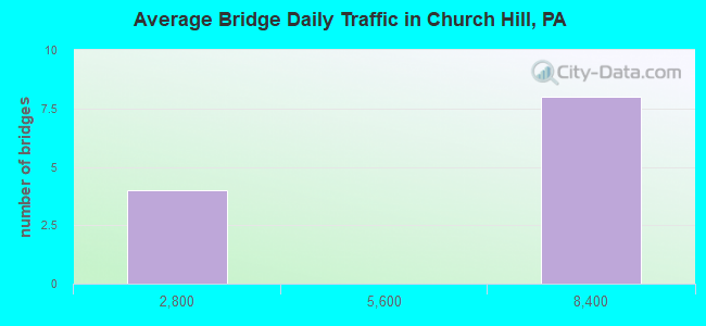
- 62,235Total average daily traffic
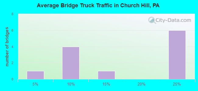
- 12,128Total average daily truck traffic
- National Bridge Inventory (NBI) Registered Bridges for Church Hill
- No street view available for this location
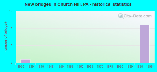
- New bridges - historical statistics
- 11930-1939
- 111990-1999
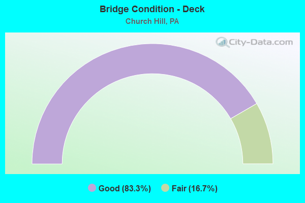
- Bridge Condition - Deck
- 83.3%Good
- 16.7%Fair
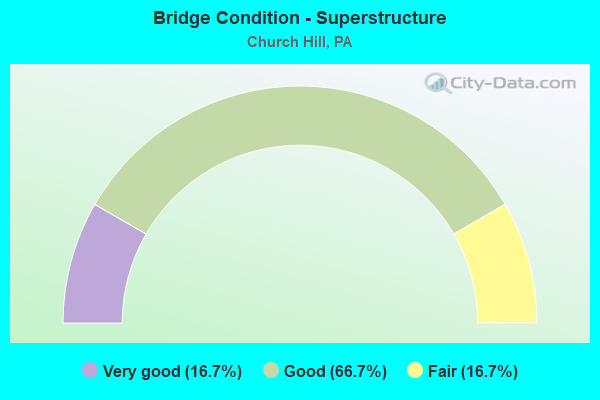
- Bridge Condition - Superstructure
- 16.7%Very good
- 66.7%Good
- 16.7%Fair
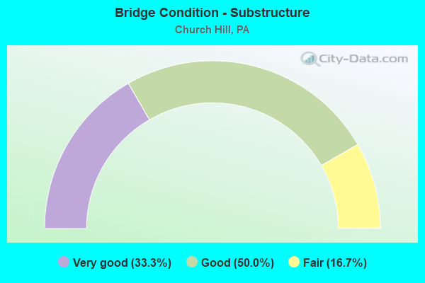
- Bridge Condition - Substructure
- 33.3%Very good
- 50.0%Good
- 16.7%Fair

- Bridge Condition - Channel
- 66.7%Good
- 33.3%Satisfactory
Find on map >> Show street view
Structure Number: 26504, Location: REEDSVILLE (Lat: 40.674067, Lng: -77.600367), Route carried "on" structure: State highway , Year Built: 1930, Status: Open, Structure Length: 1.10m (3.61ft), Average Daily Traffic: 6,266 (year 2020), Truck Traffic: 3%, Average Future Daily Traffic: 8,771 (year 2040), Design Load: H 15, Features Intersected: TEA CREEK, Facility Carried by Structure: SR 1005
Minimum Vertical Clearance: 30+ m (98+ ft), Kilometerpoint: 10.486, Lanes on structure: 3, Owner: State Highway Agency, Approaching Roadway Width: 10.4m (34.1ft), Skew: 4 degrees, Material/Design: Concrete, Design/Construction: Tee Beam, Number Of Spans In Main Unit: 1, Length of Maximum Span: 10.7m (35.1ft), Curb or Sidewalk Widths: Left: 0.2m (0.7ft), Right: 0.2m (0.7ft), Curb-To-Curb Width: 12.2m (40.0ft), Out-to-Out Width: 13.4m (44.0ft)
Condition: Deck: Fair, Superstructure: Fair, Substructure: Fair, Channel: Satisfactory, Operating Rating: 49.9 metric tons, Method Used To Determine Operating Rating: Allowable Stress (AS), Inventory Rating: 27.2 metric tons, Method Used To Determine Inventory Rating: Allowable Stress (AS), Structural Evaluation: Somewhat better than minimum adequacy, Deck Geometry: Meets minimum limits, Waterway Adequacy: Equal to present minimum criteria, Approach Roadway Alignment: Equal to present desirable criteria, Length Of Structure Improvement: 1.10m (3.61ft), Designated Inspection Frequency: Every 24 months, Inspection Date: October 2020, Bridge Improvement Cost: $39,000, Roadway Improvement Cost: $250,000, Total Project Cost: $529,000, Deck Structure Type: Concrete Cast-file-Place, Wearing Surface/Protective System: Wearing Surface: Bituminous
Find on map >> Show street view
Structure Number: 40307, Location: 1 MI N REEDSVILLE (Lat: 40.681853, Lng: -77.607969), Route carried "on" structure: US 322, Year Built: 1998, Status: Open, Structure Length: 13.38m (43.90ft), Average Daily Traffic: 7,724 (year 2021), Truck Traffic: 24%, Average Future Daily Traffic: 8,139 (year 2040), Design Load: HS 25 or greater, Features Intersected: SR 4001 AND TEA CREEK
Minimum Vertical Clearance: 30+ m (98+ ft), Kilometerpoint: 11.259, Lanes on structure: 2, Lanes under structure: 2, Base Highway Network: Yes, Owner: State Highway Agency, Approaching Roadway Width: 11.6m (38.1ft), Material/Design: Prestressed concrete continuous, Design/Construction: Stringer/Multi-beam, Number Of Spans In Main Unit: 4, Length of Maximum Span: 37.5m (123.0ft), Curb or Sidewalk Widths: Left: 0.2m (0.7ft), Right: 0.2m (0.7ft), Curb-To-Curb Width: 12.2m (40.0ft), Out-to-Out Width: 13.4m (44.0ft)
Condition: Deck: Good, Superstructure: Good, Substructure: Good, Channel: Good, Inventory Rating: 51.7 metric tons, Method Used To Determine Inventory Rating: Load Factor (LF), Structural Evaluation: Better than present minimum criteria, Deck Geometry: Better than present minimum criteria, Underclear: Meets minimum limits, Waterway Adequacy: Superior to present desirable criteria, Approach Roadway Alignment: Equal to present desirable criteria, Length Of Structure Improvement: 14.30m (46.92ft), Designated Inspection Frequency: Every 24 months, Inspection Date: October 2020, Deck Structure Type: Concrete Cast-file-Place, Wearing Surface/Protective System: Wearing Surface: Monolithic Concrete, Deck Protection: Epoxy Coated Reinforcing
Find on map >> Show street view
Structure Number: 40308, Location: 1 MI N REEDSVILLE (Lat: 40.681742, Lng: -77.607714), Route carried "on" structure: US 322, Year Built: 1998, Status: Open, Structure Length: 13.38m (43.90ft), Average Daily Traffic: 7,899 (year 2021), Truck Traffic: 23%, Average Future Daily Traffic: 8,524 (year 2040), Design Load: HS 25 or greater, Features Intersected: SR 4001 AND TEA CREEK
Minimum Vertical Clearance: 30+ m (98+ ft), Kilometerpoint: 11.249, Lanes on structure: 2, Lanes under structure: 2, Base Highway Network: Yes, Owner: State Highway Agency, Approaching Roadway Width: 11.6m (38.1ft), Material/Design: Prestressed concrete, Design/Construction: Stringer/Multi-beam, Number Of Spans In Main Unit: 4, Length of Maximum Span: 37.5m (123.0ft), Curb or Sidewalk Widths: Left: 0.2m (0.7ft), Right: 0.2m (0.7ft), Curb-To-Curb Width: 12.3m (40.4ft), Out-to-Out Width: 13.4m (44.0ft)
Condition: Deck: Good, Superstructure: Good, Substructure: Very good, Channel: Good, Inventory Rating: 51.7 metric tons, Method Used To Determine Inventory Rating: Load Factor (LF), Structural Evaluation: Better than present minimum criteria, Deck Geometry: Better than present minimum criteria, Underclear: Somewhat better than minimum adequacy, Waterway Adequacy: Superior to present desirable criteria, Approach Roadway Alignment: Equal to present desirable criteria, Length Of Structure Improvement: 14.30m (46.92ft), Designated Inspection Frequency: Every 24 months, Inspection Date: October 2020, Deck Structure Type: Concrete Cast-file-Place, Wearing Surface/Protective System: Wearing Surface: Monolithic Concrete, Deck Protection: Epoxy Coated Reinforcing
Find on map >> Show street view
Structure Number: 40319, Location: 2.5 MI N REEDSVILLE (Lat: 40.701947, Lng: -77.597494), Route carried "on" structure: State highway , Year Built: 1998, Status: Open, Structure Length: 6.37m (20.90ft), Average Daily Traffic: 7,260 (year 2021), Truck Traffic: 11%, Average Future Daily Traffic: 8,330 (year 2040), Design Load: HS 25 or greater, Features Intersected: US SR 322, Facility Carried by Structure: SR 1006
Minimum Vertical Clearance: 30+ m (98+ ft), Kilometerpoint: 0.000, Lanes on structure: 2, Lanes under structure: 10, Owner: State Highway Agency, Approaching Roadway Width: 18.3m (60.0ft), Skew: 30 degrees, Material/Design: Prestressed concrete continuous, Design/Construction: Stringer/Multi-beam, Number Of Spans In Main Unit: 2, Length of Maximum Span: 32.9m (107.9ft), Curb or Sidewalk Widths: Left: 0.2m (0.7ft), Right: 0.2m (0.7ft), Curb-To-Curb Width: 17.8m (58.4ft), Out-to-Out Width: 19.4m (63.6ft)
Condition: Deck: Good, Superstructure: Very good, Substructure: Very good, Inventory Rating: 65.3 metric tons, Method Used To Determine Inventory Rating: Load Factor (LF), Structural Evaluation: Equal to present desirable criteria, Deck Geometry: Superior to present desirable criteria, Underclear: Equal to present minimum criteria, Approach Roadway Alignment: Equal to present desirable criteria, Length Of Structure Improvement: 7.30m (23.95ft), Designated Inspection Frequency: Every 24 months, Inspection Date: May 2020, Deck Structure Type: Concrete Cast-file-Place, Wearing Surface/Protective System: Wearing Surface: Monolithic Concrete, Deck Protection: Epoxy Coated Reinforcing
Find on map >> Show street view
Structure Number: 40637, Location: 2 MI NW OF MILROY (Lat: 40.710625, Lng: -77.598906), Route carried "on" structure: US 322, Year Built: 1999, Status: Open, Structure Length: 2.83m (9.28ft), Average Daily Traffic: 7,724 (year 2021), Truck Traffic: 24%, Average Future Daily Traffic: 8,139 (year 2040), Design Load: HS 25 or greater, Features Intersected: SR 4006
Minimum Vertical Clearance: 30+ m (98+ ft), Kilometerpoint: 7.892, Lanes on structure: 2, Lanes under structure: 2, Base Highway Network: Yes, Owner: State Highway Agency, Approaching Roadway Width: 12.2m (40.0ft), Skew: 2 degrees, Material/Design: Prestressed concrete, Design/Construction: Box Beam or Girders - Single/Spread, Number Of Spans In Main Unit: 1, Length of Maximum Span: 27.1m (88.9ft), Curb or Sidewalk Widths: Left: 0.2m (0.7ft), Right: 0.2m (0.7ft), Curb-To-Curb Width: 12.2m (40.0ft), Out-to-Out Width: 13.3m (43.6ft)
Condition: Deck: Good, Superstructure: Good, Substructure: Good, Operating Rating: 98.0 metric tons, Method Used To Determine Operating Rating: Load Factor (LF), Inventory Rating: 48.1 metric tons, Method Used To Determine Inventory Rating: Load Factor (LF), Structural Evaluation: Better than present minimum criteria, Deck Geometry: Better than present minimum criteria, Underclear: Meets minimum limits, Approach Roadway Alignment: Equal to present desirable criteria, Length Of Structure Improvement: 3.60m (11.81ft), Designated Inspection Frequency: Every 24 months, Inspection Date: May 2020, Deck Structure Type: Concrete Cast-file-Place, Wearing Surface/Protective System: Wearing Surface: Monolithic Concrete, Deck Protection: Epoxy Coated Reinforcing
Find on map >> Show street view
Structure Number: 40641, Location: NORTH MILROY (Lat: 40.710592, Lng: -77.598667), Route carried "on" structure: US 322, Year Built: 1999, Status: Open, Structure Length: 2.83m (9.28ft), Average Daily Traffic: 7,899 (year 2021), Truck Traffic: 23%, Average Future Daily Traffic: 8,524 (year 2040), Design Load: HS 25 or greater, Features Intersected: SR 4006
Minimum Vertical Clearance: 30+ m (98+ ft), Kilometerpoint: 7.886, Lanes on structure: 2, Lanes under structure: 2, Base Highway Network: Yes, Owner: State Highway Agency, Approaching Roadway Width: 12.2m (40.0ft), Skew: 2 degrees, Material/Design: Prestressed concrete, Design/Construction: Box Beam or Girders - Single/Spread, Number Of Spans In Main Unit: 1, Length of Maximum Span: 27.1m (88.9ft), Curb or Sidewalk Widths: Left: 0.2m (0.7ft), Right: 0.2m (0.7ft), Curb-To-Curb Width: 12.2m (40.0ft), Out-to-Out Width: 13.3m (43.6ft)
Condition: Deck: Good, Superstructure: Good, Substructure: Good, Operating Rating: 98.0 metric tons, Method Used To Determine Operating Rating: Load Factor (LF), Inventory Rating: 48.1 metric tons, Method Used To Determine Inventory Rating: Load Factor (LF), Structural Evaluation: Better than present minimum criteria, Deck Geometry: Better than present minimum criteria, Underclear: Meets minimum limits, Approach Roadway Alignment: Equal to present desirable criteria, Length Of Structure Improvement: 3.60m (11.81ft), Designated Inspection Frequency: Every 24 months, Inspection Date: May 2020, Deck Structure Type: Concrete Cast-file-Place, Wearing Surface/Protective System: Wearing Surface: Monolithic Concrete, Deck Protection: Epoxy Coated Reinforcing
Find on map >> Show street view
Structure Number: 40307, Location: 1 MI N REEDSVILLE (Lat: 40.681853, Lng: -77.607969), Route carried "under" structure: State highway , Year Built: 1998, Structure Length: 0. m, Average Daily Traffic: 502 (year 2022), Truck Traffic: 7%, Features Intersected: SR 4001 AND TEA CREEK, Facility Carried by Structure: SR 322-US 322
Minimum Vertical Clearance: 5.34m (17.52ft), Kilometerpoint: 0.000, Lanes on structure: 2, Lanes under structure: 2, Material/Design: Prestressed concrete continuous, Design/Construction: Stringer/Multi-beam, Length of Maximum Span: 37.5m (123.0ft)
Find on map >> Show street view
Structure Number: 40308, Location: 1 MI N REEDSVILLE (Lat: 40.681742, Lng: -77.607714), Route carried "under" structure: State highway , Year Built: 1998, Structure Length: 0. m, Average Daily Traffic: 502 (year 2022), Truck Traffic: 7%, Features Intersected: SR 4001 AND TEA CREEK, Facility Carried by Structure: SR 322-US 322
Minimum Vertical Clearance: 5.88m (19.29ft), Kilometerpoint: 0.000, Lanes on structure: 2, Lanes under structure: 2, Material/Design: Prestressed concrete, Design/Construction: Stringer/Multi-beam, Length of Maximum Span: 37.5m (123.0ft)
Find on map >> Show street view
Structure Number: 40319, Location: 2.5 MI N REEDSVILLE (Lat: 40.701947, Lng: -77.597494), Route carried "under" structure: US 322, Year Built: 1998, Structure Length: 0. m, Average Daily Traffic: 7,724 (year 2021), Truck Traffic: 24%, Features Intersected: US SR 322, Facility Carried by Structure: SR 1006
Minimum Vertical Clearance: 5.18m (16.99ft), Kilometerpoint: 8.877, Lanes on structure: 2, Lanes under structure: 5, Material/Design: Prestressed concrete continuous, Design/Construction: Stringer/Multi-beam, Length of Maximum Span: 32.9m (107.9ft)
Find on map >> Show street view
Structure Number: 40319, Location: 2.5 MI N REEDSVILLE (Lat: 40.701947, Lng: -77.597494), Route carried "under" structure: US 322, Year Built: 1998, Structure Length: 0. m, Average Daily Traffic: 7,899 (year 2021), Truck Traffic: 23%, Features Intersected: US SR 322, Facility Carried by Structure: SR 1006
Minimum Vertical Clearance: 5.14m (16.86ft), Kilometerpoint: 8.869, Lanes on structure: 2, Lanes under structure: 5, Material/Design: Prestressed concrete continuous, Design/Construction: Stringer/Multi-beam, Length of Maximum Span: 32.9m (107.9ft)
Find on map >> Show street view
Structure Number: 40637, Location: 2 MI NW OF MILROY (Lat: 40.710625, Lng: -77.598906), Route carried "under" structure: State highway , Year Built: 1999, Structure Length: 0. m, Average Daily Traffic: 418 (year 2021), Truck Traffic: 8%, Features Intersected: SR 4006, Facility Carried by Structure: SR 322-US 322 E.B.
Minimum Vertical Clearance: 4.95m (16.24ft), Kilometerpoint: 16.943, Lanes on structure: 2, Lanes under structure: 2, Material/Design: Prestressed concrete, Design/Construction: Box Beam or Girders - Single/Spread, Length of Maximum Span: 27.1m (88.9ft)
Find on map >> Show street view
Structure Number: 40641, Location: NORTH MILROY (Lat: 40.710592, Lng: -77.598667), Route carried "under" structure: State highway , Year Built: 1999, Structure Length: 0. m, Average Daily Traffic: 418 (year 2021), Truck Traffic: 8%, Features Intersected: SR 4006, Facility Carried by Structure: SR 322-US 322 W.B.
Minimum Vertical Clearance: 5.47m (17.95ft), Kilometerpoint: 16.943, Lanes on structure: 2, Lanes under structure: 2, Material/Design: Prestressed concrete, Design/Construction: Box Beam or Girders - Single/Spread, Length of Maximum Span: 27.1m (88.9ft)