Bridge Statistics for Cicero, Illinois (IL)
Condition, Traffic, Stress, Structural Evaluation, Project Costs
- National Bridge Inventory (NBI) Statistics
- 22Number of bridges
- 246ft / 75.1mTotal length
- $23,432,000Total costs
- 417,650Total average daily traffic
- 30,132Total average daily truck traffic
- National Bridge Inventory (NBI) Registered Bridges for Cicero
- No street view available for this location
- New bridges - historical statistics
- 81900-1909
- 41950-1959
- 41960-1969
- 51990-1999
- 12000-2009
- Reconstructed bridges - Historical Statistics
- 11950-1959
- 01960-1969
- 01970-1979
- 01980-1989
- 21990-1999
- 12000-2009
- Bridge Condition - Deck
- 16.7%Very good
- 16.7%Good
- 50.0%Satisfactory
- 16.7%Poor
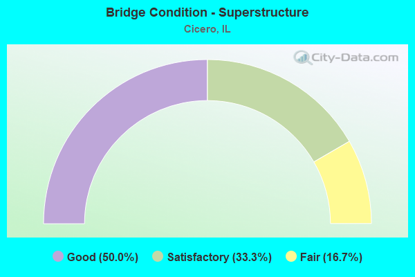
- Bridge Condition - Superstructure
- 50.0%Good
- 33.3%Satisfactory
- 16.7%Fair
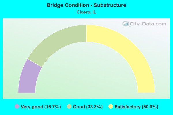
- Bridge Condition - Substructure
- 16.7%Very good
- 33.3%Good
- 50.0%Satisfactory
Find on map >> Show street view
Structure Number: 160871, Location: 0.3 M E IL 50 (Lat: 41.836711, Lng: -87.739175), Route carried "on" structure: Other road , Year Built: 1957, Year Reconstructed: 2009, Status: Open, Structure Length: 15.09m (49.51ft), Average Daily Traffic: 9,450 (year 2021), Truck Traffic: 5%, Average Future Daily Traffic: 6,798 (year 2032), Design Load: HS 20+Mod, Features Intersected: RR - BNSF & BRC, Facility Carried by Structure: 31ST ST
Minimum Vertical Clearance: 30+ m (98+ ft), Kilometerpoint: 2.848, Lanes on structure: 2, Base Highway Network: Yes, Owner: State Highway Agency, Approaching Roadway Width: 15.4m (50.5ft), Material/Design: Steel continuous, Design/Construction: Stringer/Multi-beam, Number Of Spans In Main Unit: 7, Length of Maximum Span: 26.2m (86.0ft), Curb or Sidewalk Widths: Left: 2.1m (6.9ft), Right: 2.1m (6.9ft), Curb-To-Curb Width: 9.6m (31.5ft), Out-to-Out Width: 14.5m (47.6ft)
Condition: Deck: Satisfactory, Superstructure: Fair, Substructure: Good, Operating Rating: 68.7 metric tons, Method Used To Determine Operating Rating: Load Factor (LF) rating reported by rating factor (RF) method using MS18 loading, Inventory Rating: 41.1 metric tons, Method Used To Determine Inventory Rating: Load Factor (LF) rating reported by rating factor (RF) method using MS18 loading, Structural Evaluation: Somewhat better than minimum adequacy, Deck Geometry: Meets minimum limits, Underclear: High priority of replacement, Approach Roadway Alignment: Equal to present minimum criteria, Length Of Structure Improvement: 15.85m (52.00ft), Designated Inspection Frequency: Every 24 months, Inspection Date: December 2019, Bridge Improvement Cost: $4,726,000, Roadway Improvement Cost: $473,000, Total Project Cost: $7,089,000, Deck Structure Type: Concrete Cast-file-Place
Find on map >> Show street view
Structure Number: 161069, Location: 1.9 M S I-290 (Lat: 41.844836, Lng: -87.744025), Route carried "on" structure: Other road , Year Built: 1964, Year Reconstructed: 1999, Status: Open, Structure Length: 5.39m (17.68ft), Average Daily Traffic: 18,700 (year 2021), Truck Traffic: 5%, Average Future Daily Traffic: 10,197 (year 2032), Design Load: HS 20, Features Intersected: IL 50 (CICERO AVE), Facility Carried by Structure: 26TH ST BYPASS
Minimum Vertical Clearance: 30+ m (98+ ft), Kilometerpoint: 8.256, Lanes on structure: 2, Lanes under structure: 7, Base Highway Network: Yes, Owner: State Highway Agency, Approaching Roadway Width: 12.0m (39.4ft), Material/Design: Steel continuous, Design/Construction: Stringer/Multi-beam, Number Of Spans In Main Unit: 3, Length of Maximum Span: 22.2m (72.8ft), Curb-To-Curb Width: 12.0m (39.4ft), Out-to-Out Width: 13.0m (42.7ft)
Condition: Deck: Very good, Superstructure: Good, Substructure: Satisfactory, Operating Rating: 85.5 metric tons, Method Used To Determine Operating Rating: Load Factor (LF) rating reported by rating factor (RF) method using MS18 loading, Inventory Rating: 51.5 metric tons, Method Used To Determine Inventory Rating: Load Factor (LF) rating reported by rating factor (RF) method using MS18 loading, Structural Evaluation: Equal to present minimum criteria, Deck Geometry: Better than present minimum criteria, Underclear: High priority of corrective action, Approach Roadway Alignment: Better than present minimum criteria, Length Of Structure Improvement: 6.40m (21.00ft), Designated Inspection Frequency: Every 24 months, Inspection Date: October 2021, Bridge Improvement Cost: $474,000, Roadway Improvement Cost: $47,000, Total Project Cost: $711,000, Deck Structure Type: Concrete Cast-file-Place, Wearing Surface/Protective System: Deck Protection: Epoxy Coated Reinforcing
Find on map >> Show street view
Structure Number: 162465, Location: BT W-E PK LOT (Lat: 41.844672, Lng: -87.741914), Route carried "on" structure: Other road , Year Built: 1900, Year Reconstructed: 1964, Status: Open, Structure Length: 1.55m (5.09ft), Average Daily Traffic: 100 (year 2020), Average Future Daily Traffic: 19,673 (year 2032), Design Load: HS 20, Features Intersected: 26TH ST CONNECTION, Facility Carried by Structure: WEST-ELE SERVICE R
Minimum Vertical Clearance: 30+ m (98+ ft), Kilometerpoint: 0.129, Lanes on structure: 2, Lanes under structure: 2, Owner: State Highway Agency, Approaching Roadway Width: 3.0m (9.8ft), Material/Design: Steel, Design/Construction: Stringer/Multi-beam, Number Of Spans In Main Unit: 1, Length of Maximum Span: 15.5m (50.9ft), Curb-To-Curb Width: 5.5m (18.0ft), Out-to-Out Width: 8.2m (26.9ft)
Condition: Deck: Poor, Superstructure: Satisfactory, Substructure: Satisfactory, Operating Rating: 97.2 metric tons, Method Used To Determine Operating Rating: Load Factor (LF) rating reported by rating factor (RF) method using MS18 loading, Inventory Rating: 51.8 metric tons, Method Used To Determine Inventory Rating: Load Factor (LF) rating reported by rating factor (RF) method using MS18 loading, Structural Evaluation: Equal to present minimum criteria, Deck Geometry: Meets minimum limits, Underclear: High priority of replacement, Approach Roadway Alignment: Better than present minimum criteria, Length Of Structure Improvement: 2.16m (7.09ft), Designated Inspection Frequency: Every 24 months, Inspection Date: March 2020, Bridge Improvement Cost: $182,000, Roadway Improvement Cost: $18,000, Total Project Cost: $273,000, Deck Structure Type: Concrete Cast-file-Place
Find on map >> Show street view
Structure Number: 162705, Location: 1.9 MI S OF I-290 (Lat: 41.843956, Lng: -87.744408), Route carried "on" structure: Other road , Year Built: 1999, Status: Open, Structure Length: 3.72m (12.20ft), Average Daily Traffic: 23,200 (year 2018), Truck Traffic: 7%, Average Future Daily Traffic: 24,411 (year 2032), Design Load: HS 20, Features Intersected: IL 50 (CICERO AVE), Facility Carried by Structure: OGDEN AVE
Minimum Vertical Clearance: 30+ m (98+ ft), Kilometerpoint: 15.401, Lanes on structure: 5, Lanes under structure: 4, Base Highway Network: Yes, Owner: State Highway Agency, Approaching Roadway Width: 21.6m (70.9ft), Material/Design: Steel continuous, Design/Construction: Stringer/Multi-beam, Number Of Spans In Main Unit: 2, Length of Maximum Span: 22.9m (75.1ft), Curb or Sidewalk Widths: Left: 0.0m, Right: 2.4m (7.9ft), Curb-To-Curb Width: 25.1m (82.3ft), Out-to-Out Width: 28.3m (92.8ft)
Condition: Deck: Satisfactory, Superstructure: Good, Substructure: Good, Operating Rating: 83.6 metric tons, Method Used To Determine Operating Rating: Load Factor (LF) rating reported by rating factor (RF) method using MS18 loading, Inventory Rating: 50.2 metric tons, Method Used To Determine Inventory Rating: Load Factor (LF) rating reported by rating factor (RF) method using MS18 loading, Structural Evaluation: Better than present minimum criteria, Deck Geometry: Superior to present desirable criteria, Underclear: Somewhat better than minimum adequacy, Approach Roadway Alignment: Equal to present desirable criteria, Designated Inspection Frequency: Every 48 months, Inspection Date: October 2021, Deck Structure Type: Concrete Cast-file-Place, Wearing Surface/Protective System: Deck Protection: Epoxy Coated Reinforcing
Find on map >> Show street view
Structure Number: 162726, Location: EAST OF IL 50 (Lat: 41.844847, Lng: -87.741244), Route carried "on" structure: Other road , Year Built: 1999, Status: Open, Structure Length: 3.13m (10.27ft), Average Daily Traffic: 100 (year 2020), Average Future Daily Traffic: 19,673 (year 2032), Features Intersected: OGDEN AVE, Facility Carried by Structure: SERVICE RD
Minimum Vertical Clearance: 30+ m (98+ ft), Kilometerpoint: 0.193, Lanes on structure: 1, Lanes under structure: 4, Owner: State Highway Agency, Approaching Roadway Width: 3.6m (11.8ft), Material/Design: Steel, Design/Construction: Stringer/Multi-beam, Number Of Spans In Main Unit: 2, Length of Maximum Span: 15.6m (51.2ft), Curb-To-Curb Width: 3.6m (11.8ft), Out-to-Out Width: 4.6m (15.1ft)
Condition: Deck: Good, Superstructure: Good, Substructure: Very good, Operating Rating: 89.1 metric tons, Method Used To Determine Operating Rating: Load Factor (LF) rating reported by rating factor (RF) method using MS18 loading, Inventory Rating: 82.0 metric tons, Method Used To Determine Inventory Rating: Load Factor (LF) rating reported by rating factor (RF) method using MS18 loading, Structural Evaluation: Better than present minimum criteria, Deck Geometry: High priority of corrective action, Underclear: Superior to present desirable criteria, Approach Roadway Alignment: Equal to present desirable criteria, Designated Inspection Frequency: Every 48 months, Inspection Date: October 2019, Deck Structure Type: Concrete Cast-file-Place, Wearing Surface/Protective System: Deck Protection: Epoxy Coated Reinforcing
Find on map >> Show street view
Structure Number: 167856, Location: S OF 22ND P16 (Lat: 41.844125, Lng: -87.753886), Route carried "on" structure: Other road , Year Built: 1956, Year Reconstructed: 1999, Status: Open, Structure Length: 46.18m (151.51ft), Average Daily Traffic: 13,900 (year 2018), Truck Traffic: 7%, Average Future Daily Traffic: 17,407 (year 2032), Design Load: HS 20, Features Intersected: OGDEN AVE & RR YARD, Facility Carried by Structure: LARAMIE AVE
Minimum Vertical Clearance: 30+ m (98+ ft), Kilometerpoint: 12.971, Lanes on structure: 4, Lanes under structure: 6, Owner: City or Municipal Highway Agency, Approaching Roadway Width: 14.6m (47.9ft), Skew: 31 degrees, Material/Design: Steel continuous, Design/Construction: Stringer/Multi-beam, Number Of Spans In Main Unit: 10, Number Of Approach Spans: 6, Length of Maximum Span: 44.3m (145.3ft), Curb or Sidewalk Widths: Left: 1.5m (4.9ft), Right: 1.5m (4.9ft), Curb-To-Curb Width: 14.6m (47.9ft), Out-to-Out Width: 19.5m (64.0ft)
Condition: Deck: Satisfactory, Superstructure: Satisfactory, Substructure: Satisfactory, Operating Rating: 53.8 metric tons, Method Used To Determine Operating Rating: Load Factor (LF) rating reported by rating factor (RF) method using MS18 loading, Inventory Rating: 32.4 metric tons, Method Used To Determine Inventory Rating: Load Factor (LF) rating reported by rating factor (RF) method using MS18 loading, Structural Evaluation: Equal to present minimum criteria, Deck Geometry: High priority of replacement, Underclear: Equal to present minimum criteria, Approach Roadway Alignment: Equal to present desirable criteria, Length Of Structure Improvement: 46.18m (151.51ft), Designated Inspection Frequency: Every 24 months, Inspection Date: October 2021, Bridge Improvement Cost: $10,239,000, Roadway Improvement Cost: $1,024,000, Total Project Cost: $15,359,000, Deck Structure Type: Concrete Cast-file-Place, Wearing Surface/Protective System: Deck Protection: Epoxy Coated Reinforcing
Find on map >> Show street view
Structure Number: 160227, Location: AT AUSTIN BLVD P16 (Lat: 41.834000, Lng: -87.773219), Route carried "under" structure: Other road , Year Built: 1900, Structure Length: 0. m, Average Daily Traffic: 20,400 (year 2018), Truck Traffic: 7%, Features Intersected: US34 OGDEN AV, Facility Carried by Structure: CC RR
Minimum Vertical Clearance: 4.42m (14.50ft), Kilometerpoint: 12.746, Lanes under structure: 4, Material/Design: Steel, Length of Maximum Span: 41.8m (137.1ft)
Find on map >> Show street view
Structure Number: 160229, Location: 0.25 E ILL 50 P4C,16 (Lat: 41.845833, Lng: -87.739625), Route carried "under" structure: Other road , Year Built: 1900, Structure Length: 0. m, Average Daily Traffic: 10,750 (year 2021), Truck Traffic: 6%, Features Intersected: OGDEN AVE, Facility Carried by Structure: IHB RR
Minimum Vertical Clearance: 4.85m (15.91ft), Kilometerpoint: 0.435, Lanes under structure: 4, Material/Design: Steel, Length of Maximum Span: 15.8m (51.8ft)
Find on map >> Show street view
Structure Number: 16023, Location: 0.28 M E IL50 P4C,16 (Lat: 41.845997, Lng: -87.739106), Route carried "under" structure: Other road , Year Built: 1900, Structure Length: 0. m, Average Daily Traffic: 10,750 (year 2021), Truck Traffic: 6%, Features Intersected: OGDEN AVE, Facility Carried by Structure: IHB RR
Minimum Vertical Clearance: 4.29m (14.07ft), Kilometerpoint: 0.483, Lanes under structure: 4, Material/Design: Steel, Length of Maximum Span: 18.0m (59.1ft)
Find on map >> Show street view
Structure Number: 160408, Location: 1.9 M S I-290 (Lat: 41.844400, Lng: -87.744011), Route carried "under" structure: State highway 50, Year Built: 1964, Structure Length: 0. m, Average Daily Traffic: 35,600 (year 2021), Truck Traffic: 9%, Features Intersected: IL 50 (CICERO AVE), Facility Carried by Structure: RR - BNSF
Minimum Vertical Clearance: 4.39m (14.40ft), Kilometerpoint: 85.840, Lanes under structure: 6, Material/Design: Steel, Design/Construction: Stringer/Multi-beam, Length of Maximum Span: 21.3m (69.9ft)
Find on map >> Show street view
Structure Number: 160409, Location: 0.1 M E IL 50 (Lat: 41.844819, Lng: -87.741981), Route carried "under" structure: Other road , Year Built: 1964, Structure Length: 0. m, Average Daily Traffic: 18,700 (year 2021), Truck Traffic: 5%, Features Intersected: 26TH ST, Facility Carried by Structure: RR - BNSF
Minimum Vertical Clearance: 4.50m (14.76ft), Kilometerpoint: 8.449, Lanes under structure: 2, Material/Design: Steel, Design/Construction: Stringer/Multi-beam, Length of Maximum Span: 14.3m (46.9ft)
Find on map >> Show street view
Structure Number: 160635, Location: 0.2 M E IL 50 P4C,16 (Lat: 41.851281, Lng: -87.740231), Route carried "under" structure: Other road , Year Built: 1900, Structure Length: 0. m, Average Daily Traffic: 21,400 (year 2021), Truck Traffic: 4%, Features Intersected: CERMAK (22ND ST), Facility Carried by Structure: BRC RR (WEST)
Minimum Vertical Clearance: 5.03m (16.50ft), Kilometerpoint: 15.015, Lanes under structure: 4, Material/Design: Steel, Length of Maximum Span: 21.3m (69.9ft)
Find on map >> Show street view
Structure Number: 160636, Location: 0.22 M E IL50 P4C,16 (Lat: 41.851283, Lng: -87.740036), Route carried "under" structure: Other road , Year Built: 1900, Structure Length: 0. m, Average Daily Traffic: 21,400 (year 2021), Truck Traffic: 4%, Features Intersected: CERMAK (22ND ST), Facility Carried by Structure: BRC RR (EAST)
Minimum Vertical Clearance: 4.11m (13.48ft), Kilometerpoint: 15.031, Lanes under structure: 4, Material/Design: Steel, Length of Maximum Span: 7.6m (24.9ft)
Find on map >> Show street view
Structure Number: 161069, Location: 1.9 M S I-290 (Lat: 41.844836, Lng: -87.744025), Route carried "under" structure: State highway 50, Year Built: 1964, Structure Length: 0. m, Average Daily Traffic: 35,600 (year 2021), Truck Traffic: 9%, Features Intersected: IL 50 (CICERO AVE), Facility Carried by Structure: 26TH ST BYPASS
Minimum Vertical Clearance: 4.45m (14.60ft), Kilometerpoint: 85.904, Lanes on structure: 2, Lanes under structure: 7, Material/Design: Steel continuous, Design/Construction: Stringer/Multi-beam, Length of Maximum Span: 22.2m (72.8ft)
Find on map >> Show street view
Structure Number: 162465, Location: BT W-E PK LOT (Lat: 41.844672, Lng: -87.741914), Route carried "under" structure: Other road , Year Built: 1900, Structure Length: 0. m, Average Daily Traffic: 18,700 (year 2021), Truck Traffic: 5%, Features Intersected: 26TH ST CONNECTION, Facility Carried by Structure: WEST-ELE SERVICE R
Minimum Vertical Clearance: 4.78m (15.68ft), Kilometerpoint: 8.465, Lanes on structure: 2, Lanes under structure: 2, Material/Design: Steel, Design/Construction: Stringer/Multi-beam, Length of Maximum Span: 15.5m (50.9ft)
Find on map >> Show street view
Structure Number: 162705, Location: 1.9 MI S OF I-290 (Lat: 41.843969, Lng: -87.743997), Route carried "under" structure: State highway 50, Year Built: 1999, Structure Length: 0. m, Average Daily Traffic: 35,600 (year 2021), Truck Traffic: 9%, Features Intersected: IL 50 (CICERO AVE), Facility Carried by Structure: OGDEN AVE
Minimum Vertical Clearance: 4.67m (15.32ft), Kilometerpoint: 85.792, Lanes on structure: 5, Lanes under structure: 4, Material/Design: Steel continuous, Design/Construction: Stringer/Multi-beam, Length of Maximum Span: 22.9m (75.1ft)
Find on map >> Show street view
Structure Number: 162707, Location: 0.1 M E OF IL 50 (Lat: 41.845133, Lng: -87.740739), Route carried "under" structure: Other road , Year Built: 2001, Structure Length: 0. m, Average Daily Traffic: 10,750 (year 2021), Truck Traffic: 6%, Features Intersected: OGDEN AVE, Facility Carried by Structure: RR - BNSF
Minimum Vertical Clearance: 4.65m (15.26ft), Kilometerpoint: 0.306, Lanes under structure: 2, Material/Design: Steel continuous, Design/Construction: Stringer/Multi-beam, Length of Maximum Span: 17.6m (57.7ft)
Find on map >> Show street view
Structure Number: 162726, Location: EAST OF IL 50 (Lat: 41.845008, Lng: -87.740825), Route carried "under" structure: Other road , Year Built: 1999, Structure Length: 0. m, Average Daily Traffic: 10,750 (year 2021), Truck Traffic: 6%, Features Intersected: OGDEN AVE, Facility Carried by Structure: SERVICE RD
Minimum Vertical Clearance: 6.58m (21.59ft), Kilometerpoint: 0.290, Lanes on structure: 1, Lanes under structure: 4, Material/Design: Steel, Design/Construction: Stringer/Multi-beam, Length of Maximum Span: 15.6m (51.2ft)
Find on map >> Show street view
Structure Number: 167856, Location: S OF 22ND P16 (Lat: 41.840828, Lng: -87.753708), Route carried "under" structure: Other road , Year Built: 1956, Structure Length: 0. m, Average Daily Traffic: 23,200 (year 2018), Truck Traffic: 7%, Features Intersected: OGDEN AVE & RR YARD, Facility Carried by Structure: LARAMIE AVE
Minimum Vertical Clearance: 5.97m (19.59ft), Kilometerpoint: 14.548, Lanes on structure: 4, Lanes under structure: 4, Material/Design: Steel continuous, Design/Construction: Stringer/Multi-beam, Length of Maximum Span: 44.3m (145.3ft)
Find on map >> Show street view
Structure Number: 167856, Location: S OF 22ND P16 (Lat: 41.843819, Lng: -87.753881), Route carried "under" structure: Other road , Year Built: 1956, Structure Length: 0. m, Average Daily Traffic: 18,700 (year 2021), Truck Traffic: 5%, Features Intersected: OGDEN AVE & RR YARD, Facility Carried by Structure: LARAMIE AVE
Minimum Vertical Clearance: 5.11m (16.77ft), Kilometerpoint: 7.355, Lanes on structure: 4, Lanes under structure: 2, Material/Design: Steel continuous, Design/Construction: Stringer/Multi-beam, Length of Maximum Span: 44.3m (145.3ft)
Find on map >> Show street view
Structure Number: 169914, Location: .25 M E OF ILL 50 (Lat: 41.844033, Lng: -87.739753), Route carried "under" structure: Other road , Year Built: 1900, Structure Length: 0. m, Average Daily Traffic: 11,100 (year 2018), Truck Traffic: 9%, Features Intersected: 26TH ST, Facility Carried by Structure: BELT LINE RR
Minimum Vertical Clearance: 4.62m (15.16ft), Kilometerpoint: 8.738, Lanes under structure: 4, Material/Design: Steel, Length of Maximum Span: 21.9m (71.9ft)
Find on map >> Show street view
Structure Number: 169923, Location: 0.2M.S.OF 31ST. (Lat: 41.832847, Lng: -87.743631), Route carried "under" structure: State highway 50, Year Built: 1991, Structure Length: 0. m, Average Daily Traffic: 48,800 (year 2021), Truck Traffic: 11%, Features Intersected: IL-50 CICERO AVE., Facility Carried by Structure: CC & P RR
Minimum Vertical Clearance: 4.52m (14.83ft), Kilometerpoint: 84.569, Lanes under structure: 6, Material/Design: Steel, Design/Construction: Stringer/Multi-beam, Length of Maximum Span: 20.1m (65.9ft)