Bridge Statistics for Citrus Ridge, Florida (FL)
Condition, Traffic, Stress, Structural Evaluation, Project Costs
- National Bridge Inventory (NBI) Statistics
- 32Number of bridges
- 436ft / 133mTotal length
- $609,000Total costs
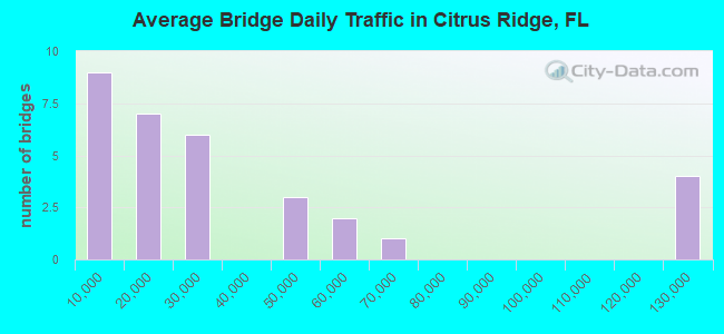
- 1,061,300Total average daily traffic
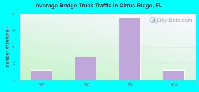
- 123,172Total average daily truck traffic
- National Bridge Inventory (NBI) Registered Bridges for Citrus Ridge
- No street view available for this location
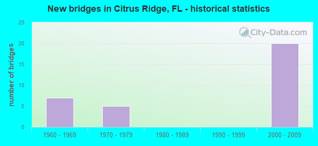
- New bridges - historical statistics
- 71960-1969
- 51970-1979
- 202000-2009
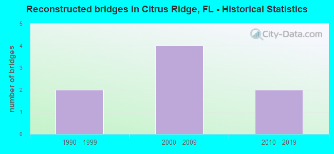
- Reconstructed bridges - Historical Statistics
- 21990-1999
- 42000-2009
- 22010-2019
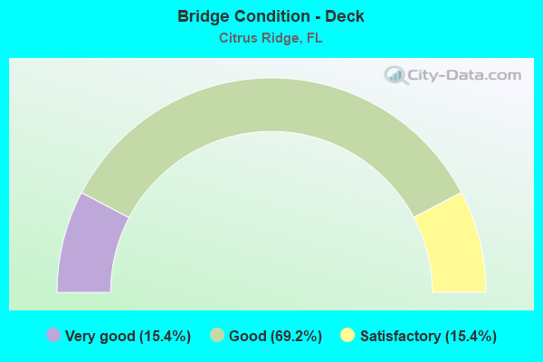
- Bridge Condition - Deck
- 15.4%Very good
- 69.2%Good
- 15.4%Satisfactory
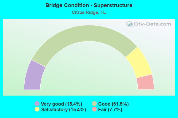
- Bridge Condition - Superstructure
- 15.4%Very good
- 61.5%Good
- 15.4%Satisfactory
- 7.7%Fair
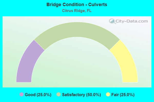
- Bridge Condition - Culverts
- 25.0%Good
- 50.0%Satisfactory
- 25.0%Fair
Find on map >> Show street view
Structure Number: 110036, Location: US-27 NB over US-192 (Lat: 28.346997, Lng: -81.673558), Route carried "on" structure: US 27, Year Built: 1971, Year Reconstructed: 2014, Status: Open, Structure Length: 5.55m (18.21ft), Average Daily Traffic: 21,250 (year 2020), Truck Traffic: 9%, Average Future Daily Traffic: 36,869 (year 2042), Design Load: HL 93, Features Intersected: US-192
Minimum Vertical Clearance: 30+ m (98+ ft), Kilometerpoint: 0.000, Lanes on structure: 3, Lanes under structure: 2, Base Highway Network: Yes, Owner: State Highway Agency, Approaching Roadway Width: 17.1m (56.1ft), Skew: 1 degrees, Material/Design: Prestressed concrete, Design/Construction: Stringer/Multi-beam, Number Of Spans In Main Unit: 2, Length of Maximum Span: 27.4m (89.9ft), Curb-To-Curb Width: 17.1m (56.1ft), Out-to-Out Width: 18.0m (59.1ft)
Condition: Deck: Satisfactory, Superstructure: Good, Substructure: Good, Operating Rating: 42.8 metric tons, Method Used To Determine Operating Rating: Load and Resistance Factor (LRFR), Inventory Rating: 38.8 metric tons, Method Used To Determine Inventory Rating: Load and Resistance Factor (LRFR), Structural Evaluation: Better than present minimum criteria, Deck Geometry: Superior to present desirable criteria, Underclear: Equal to present minimum criteria, Approach Roadway Alignment: Equal to present desirable criteria, Designated Inspection Frequency: Every 24 months, Inspection Date: December 2020, Deck Structure Type: Concrete Cast-file-Place, Wearing Surface/Protective System: Wearing Surface: Monolithic Concrete
Find on map >> Show street view
Structure Number: 11094, Location: US-27 SB over US-192 (Lat: 28.346994, Lng: -81.673783), Route carried "on" structure: US 27, Year Built: 1971, Year Reconstructed: 2016, Status: Open, Structure Length: 5.55m (18.21ft), Average Daily Traffic: 21,250 (year 2020), Truck Traffic: 9%, Average Future Daily Traffic: 36,869 (year 2042), Design Load: HL 93, Features Intersected: US-192
Minimum Vertical Clearance: 30+ m (98+ ft), Kilometerpoint: 0.000, Lanes on structure: 4, Lanes under structure: 2, Base Highway Network: Yes (Inventory Route: 112000, Subroute: 10), Owner: State Highway Agency, Approaching Roadway Width: 22.3m (73.2ft), Skew: 1 degrees, Material/Design: Prestressed concrete, Design/Construction: Stringer/Multi-beam, Number Of Spans In Main Unit: 2, Length of Maximum Span: 27.5m (90.2ft), Curb-To-Curb Width: 22.3m (73.2ft), Out-to-Out Width: 23.2m (76.1ft)
Condition: Deck: Good, Superstructure: Good, Substructure: Good, Operating Rating: 41.5 metric tons, Method Used To Determine Operating Rating: Load and Resistance Factor (LRFR), Inventory Rating: 37.6 metric tons, Method Used To Determine Inventory Rating: Load and Resistance Factor (LRFR), Structural Evaluation: Better than present minimum criteria, Deck Geometry: Superior to present desirable criteria, Underclear: Equal to present minimum criteria, Approach Roadway Alignment: Equal to present desirable criteria, Designated Inspection Frequency: Every 24 months, Inspection Date: December 2020, Deck Structure Type: Concrete Cast-file-Place, Wearing Surface/Protective System: Wearing Surface: Monolithic Concrete
Find on map >> Show street view
Structure Number: 750083, Location: .3 Mi E of Lake Co Line (Lat: 28.346919, Lng: -81.651972), Route carried "on" structure: US 192, Year Built: 1971, Year Reconstructed: 2014, Status: Open, Structure Length: 0.94m (3.08ft), Average Daily Traffic: 45,500 (year 2020), Truck Traffic: 5%, Average Future Daily Traffic: 78,942 (year 2042), Design Load: H 20, Features Intersected: Unnamed
Minimum Vertical Clearance: 30+ m (98+ ft), Kilometerpoint: 0.492, Lanes on structure: 7, Base Highway Network: Yes, Owner: State Highway Agency, Approaching Roadway Width: 30.5m (100.1ft), Skew: 20 degrees, Material/Design: Concrete, Design/Construction: Culvert, Number Of Spans In Main Unit: 3, Length of Maximum Span: 3.0m (9.8ft)
Condition: Channel: Good, Culverts: Good, Operating Rating: 42.8 metric tons, Method Used To Determine Operating Rating: Load and Resistance Factor (LRFR), Inventory Rating: 33.0 metric tons, Method Used To Determine Inventory Rating: Load and Resistance Factor (LRFR), Structural Evaluation: Better than present minimum criteria, Waterway Adequacy: Equal to present desirable criteria, Approach Roadway Alignment: Equal to present desirable criteria, Length Of Structure Improvement: 0.94m (3.08ft), Designated Inspection Frequency: Every 24 months, Inspection Date: August 2021, Bridge Improvement Cost: $10,000, Total Project Cost: $609,000
Find on map >> Show street view
Structure Number: 920094, Location: I-4 WB over CR-532 (Lat: 28.260900, Lng: -81.613339), Route carried "on" structure: Interstate 4, Year Built: 1960, Year Reconstructed: 2004, Status: Open, Structure Length: 5.48m (17.98ft), Average Daily Traffic: 57,500 (year 2020), Truck Traffic: 17%, Average Future Daily Traffic: 99,762 (year 2042), Design Load: HS 20+Mod, Features Intersected: CR-532
Minimum Vertical Clearance: 30+ m (98+ ft), Kilometerpoint: 0.164, Lanes on structure: 3, Lanes under structure: 4, Base Highway Network: Yes, Owner: State Highway Agency, Approaching Roadway Width: 15.1m (49.5ft), Skew: 2 degrees, Material/Design: Prestressed concrete, Design/Construction: Stringer/Multi-beam, Number Of Spans In Main Unit: 4, Length of Maximum Span: 15.8m (51.8ft), Curb-To-Curb Width: 15.1m (49.5ft), Out-to-Out Width: 18.0m (59.1ft)
Condition: Deck: Satisfactory, Superstructure: Good, Substructure: Good, Operating Rating: 45.1 metric tons, Method Used To Determine Operating Rating: Load Factor (LF), Inventory Rating: 27.7 metric tons, Method Used To Determine Inventory Rating: Load Factor (LF), Structural Evaluation: Equal to present minimum criteria, Deck Geometry: Meets minimum limits, Underclear: Somewhat better than minimum adequacy, Approach Roadway Alignment: Equal to present desirable criteria, Designated Inspection Frequency: Every 24 months, Inspection Date: May 2020, Deck Structure Type: Concrete Cast-file-Place, Wearing Surface/Protective System: Wearing Surface: Monolithic Concrete
Find on map >> Show street view
Structure Number: 920095, Location: I-4 EB - CR-532 (Lat: 28.260828, Lng: -81.612936), Route carried "on" structure: Interstate 4, Year Built: 1960, Year Reconstructed: 2004, Status: Open, Structure Length: 5.48m (17.98ft), Average Daily Traffic: 57,500 (year 2020), Truck Traffic: 17%, Average Future Daily Traffic: 99,762 (year 2042), Design Load: HS 20+Mod, Features Intersected: CR-532
Minimum Vertical Clearance: 30+ m (98+ ft), Kilometerpoint: 0.188, Lanes on structure: 3, Lanes under structure: 4, Base Highway Network: Yes, Owner: State Highway Agency, Approaching Roadway Width: 17.1m (56.1ft), Skew: 2 degrees, Material/Design: Prestressed concrete, Design/Construction: Stringer/Multi-beam, Number Of Spans In Main Unit: 4, Length of Maximum Span: 15.8m (51.8ft), Curb-To-Curb Width: 17.1m (56.1ft), Out-to-Out Width: 18.0m (59.1ft)
Condition: Deck: Good, Superstructure: Satisfactory, Substructure: Good, Operating Rating: 45.1 metric tons, Method Used To Determine Operating Rating: Load Factor (LF), Inventory Rating: 27.7 metric tons, Method Used To Determine Inventory Rating: Load Factor (LF), Structural Evaluation: Equal to present minimum criteria, Deck Geometry: Equal to present minimum criteria, Underclear: Somewhat better than minimum adequacy, Approach Roadway Alignment: Equal to present desirable criteria, Designated Inspection Frequency: Every 24 months, Inspection Date: May 2020, Deck Structure Type: Concrete Cast-file-Place, Wearing Surface/Protective System: Wearing Surface: Bituminous
Find on map >> Show street view
Structure Number: 920097, Location: 1.3 MI N of Polk Co. Line (Lat: 28.274356, Lng: -81.600411), Route carried "on" structure: Interstate 400, Year Built: 1960, Year Reconstructed: 2005, Status: Open, Structure Length: 8.14m (26.71ft), Average Daily Traffic: 120,000 (year 2020), Truck Traffic: 12%, Average Future Daily Traffic: 208,200 (year 2042), Design Load: HS 20+Mod, Features Intersected: Davenport Creek, Facility Carried by Structure: I-4
Minimum Vertical Clearance: 30+ m (98+ ft), Kilometerpoint: 2.173, Lanes on structure: 6, Base Highway Network: Yes, Owner: State Highway Agency, Approaching Roadway Width: 35.4m (116.1ft), Skew: 24 degrees, Material/Design: Concrete, Design/Construction: Culvert, Number Of Spans In Main Unit: 4, Length of Maximum Span: 3.7m (12.1ft)
Condition: Channel: Good, Culverts: Satisfactory, Operating Rating: 55.9 metric tons, Method Used To Determine Operating Rating: Load and Resistance Factor (LRFR), Inventory Rating: 43.1 metric tons, Method Used To Determine Inventory Rating: Load and Resistance Factor (LRFR), Structural Evaluation: Equal to present minimum criteria, Waterway Adequacy: Equal to present desirable criteria, Approach Roadway Alignment: Equal to present desirable criteria, Designated Inspection Frequency: Every 24 months, Underwater Inspection Frequency: Every 24 months, Inspection Date: May 2020, Underwater Inspection Date: May 2020
Find on map >> Show street view
Structure Number: 920202, Location: 0.8 Mi E of CR-532 (Lat: 28.270556, Lng: -81.603978), Route carried "on" structure: Interstate 400, Year Built: 1960, Year Reconstructed: 2016, Status: Open, Structure Length: 0.67m (2.20ft), Average Daily Traffic: 120,000 (year 2020), Truck Traffic: 12%, Average Future Daily Traffic: 208,200 (year 2042), Design Load: H 15, Features Intersected: Ditch, Facility Carried by Structure: I-4
Minimum Vertical Clearance: 30+ m (98+ ft), Kilometerpoint: 1.547, Lanes on structure: 6, Base Highway Network: Yes, Owner: State Highway Agency, Approaching Roadway Width: 30.5m (100.1ft), Skew: 13 degrees, Material/Design: Concrete, Design/Construction: Culvert, Number Of Spans In Main Unit: 2, Length of Maximum Span: 3.2m (10.5ft)
Condition: Channel: Good, Culverts: Fair, Operating Rating: 81.6 metric tons, Method Used To Determine Operating Rating: Load Factor (LF), Inventory Rating: 49.0 metric tons, Method Used To Determine Inventory Rating: Load Factor (LF), Structural Evaluation: Somewhat better than minimum adequacy, Waterway Adequacy: Equal to present desirable criteria, Approach Roadway Alignment: Equal to present desirable criteria, Designated Inspection Frequency: Every 24 months, Inspection Date: October 2020
Find on map >> Show street view
Structure Number: 920203, Location: 2.0 Mi N of Polk Co. Line (Lat: 28.281758, Lng: -81.593358), Route carried "on" structure: Interstate 4, Year Built: 1960, Year Reconstructed: 2006, Status: Open, Structure Length: 0.65m (2.13ft), Average Daily Traffic: 60,000 (year 2020), Truck Traffic: 12%, Average Future Daily Traffic: 104,100 (year 2042), Design Load: HS 20, Features Intersected: Ditch
Minimum Vertical Clearance: 30+ m (98+ ft), Kilometerpoint: 3.225, Lanes on structure: 6, Base Highway Network: Yes, Owner: State Highway Agency, Approaching Roadway Width: 30.5m (100.1ft), Skew: 32 degrees, Material/Design: Concrete, Design/Construction: Culvert, Number Of Spans In Main Unit: 2, Length of Maximum Span: 3.0m (9.8ft)
Condition: Channel: Good, Culverts: Satisfactory, Operating Rating: 56.8 metric tons, Method Used To Determine Operating Rating: Load Factor (LF), Inventory Rating: 34.1 metric tons, Method Used To Determine Inventory Rating: Load Factor (LF), Structural Evaluation: Equal to present minimum criteria, Waterway Adequacy: Equal to present desirable criteria, Approach Roadway Alignment: Equal to present desirable criteria, Designated Inspection Frequency: Every 24 months, Inspection Date: August 2021
Find on map >> Show street view
Structure Number: 920601, Location: SR 429 & I-4 INTERCHANGE (Lat: 28.282506, Lng: -81.593011), Route carried "on" structure: Ramp State highway 429, Year Built: 2006, Status: Open, Structure Length: 31.64m (103.81ft), Average Daily Traffic: 8,100 (year 2020), Truck Traffic: 12%, Average Future Daily Traffic: 14,054 (year 2042), Design Load: HS 20+Mod, Features Intersected: I-4 & SR 429 SB RAMP C
Minimum Vertical Clearance: 30+ m (98+ ft), Kilometerpoint: 0.669, Lanes on structure: 1, Lanes under structure: 7, Toll: On toll road, Owner: State Toll Authority, Approaching Roadway Width: 13.1m (43.0ft), Skew: 9 degrees, Material/Design: Steel continuous, Design/Construction: Box Beam or Girders - Single/Spread, Number Of Spans In Main Unit: 5, Length of Maximum Span: 77.8m (255.2ft), Curb-To-Curb Width: 14.0m (45.9ft), Out-to-Out Width: 15.0m (49.2ft)
Condition: Deck: Good, Superstructure: Good, Substructure: Good, Operating Rating: 59.1 metric tons, Method Used To Determine Operating Rating: Load Factor (LF), Inventory Rating: 36.3 metric tons, Method Used To Determine Inventory Rating: Load Factor (LF), Structural Evaluation: Better than present minimum criteria, Deck Geometry: Superior to present desirable criteria, Underclear: Equal to present desirable criteria, Approach Roadway Alignment: Equal to present desirable criteria, Designated Inspection Frequency: Every 24 months, Critical Feature Inspection Frequency: Every 24 months, Inspection Date: January 2022, Critical Feature Inspection Date: January 2022, Deck Structure Type: Concrete Cast-file-Place
Find on map >> Show street view
Structure Number: 920602, Location: SR 429 & I-4 INTERCHANGE (Lat: 28.282847, Lng: -81.591517), Route carried "on" structure: Ramp State highway 429, Year Built: 2006, Status: Open, Structure Length: 35.59m (116.77ft), Average Daily Traffic: 2,300 (year 2020), Truck Traffic: 12%, Average Future Daily Traffic: 3,990 (year 2042), Design Load: HS 20+Mod, Features Intersected: I-4 & CR 545
Minimum Vertical Clearance: 5.18m (16.99ft), Kilometerpoint: 0.312, Lanes on structure: 1, Lanes under structure: 8, Toll: On toll road, Owner: State Toll Authority, Approaching Roadway Width: 13.1m (43.0ft), Material/Design: Steel continuous, Design/Construction: Box Beam or Girders - Single/Spread, Number Of Spans In Main Unit: 7, Length of Maximum Span: 71.0m (232.9ft), Curb-To-Curb Width: 14.0m (45.9ft), Out-to-Out Width: 15.0m (49.2ft)
Condition: Deck: Good, Superstructure: Fair, Substructure: Good, Operating Rating: 56.5 metric tons, Method Used To Determine Operating Rating: Load Factor (LF), Inventory Rating: 33.9 metric tons, Method Used To Determine Inventory Rating: Load Factor (LF), Structural Evaluation: Somewhat better than minimum adequacy, Deck Geometry: Equal to present desirable criteria, Underclear: Better than present minimum criteria, Approach Roadway Alignment: Equal to present desirable criteria, Designated Inspection Frequency: Every 24 months, Critical Feature Inspection Frequency: Every 24 months, Inspection Date: January 2022, Critical Feature Inspection Date: January 2022, Deck Structure Type: Concrete Cast-file-Place
Find on map >> Show street view
Structure Number: 920603, Location: 1.7 MI NORTH OF I-4 (Lat: 28.303186, Lng: -81.607617), Route carried "on" structure: State highway 429, Year Built: 2006, Status: Open, Structure Length: 2.15m (7.05ft), Average Daily Traffic: 12,100 (year 2020), Truck Traffic: 12%, Average Future Daily Traffic: 20,994 (year 2042), Design Load: HS 20+Mod, Features Intersected: SAND HILL ROAD
Minimum Vertical Clearance: 30+ m (98+ ft), Kilometerpoint: 2.194, Lanes on structure: 2, Lanes under structure: 2, Base Highway Network: Yes, Toll: On toll road, Owner: State Toll Authority, Approaching Roadway Width: 12.2m (40.0ft), Material/Design: Prestressed concrete, Design/Construction: Stringer/Multi-beam, Number Of Spans In Main Unit: 1, Length of Maximum Span: 21.5m (70.5ft), Curb-To-Curb Width: 14.0m (45.9ft), Out-to-Out Width: 15.0m (49.2ft)
Condition: Deck: Very good, Superstructure: Very good, Substructure: Good, Operating Rating: 57.2 metric tons, Method Used To Determine Operating Rating: Load Factor (LF), Inventory Rating: 32.9 metric tons, Method Used To Determine Inventory Rating: Load Factor (LF), Structural Evaluation: Better than present minimum criteria, Deck Geometry: Superior to present desirable criteria, Underclear: Superior to present desirable criteria, Approach Roadway Alignment: Equal to present desirable criteria, Designated Inspection Frequency: Every 24 months, Inspection Date: November 2021, Deck Structure Type: Concrete Cast-file-Place
Find on map >> Show street view
Structure Number: 920604, Location: 1.7 MI NORTH OF I-4 (Lat: 28.303197, Lng: -81.607339), Route carried "on" structure: State highway 429, Year Built: 2006, Status: Open, Structure Length: 2.15m (7.05ft), Average Daily Traffic: 12,100 (year 2020), Truck Traffic: 12%, Average Future Daily Traffic: 20,994 (year 2042), Design Load: HS 20+Mod, Features Intersected: SAND HILL ROAD
Minimum Vertical Clearance: 30+ m (98+ ft), Kilometerpoint: 2.194, Lanes on structure: 2, Lanes under structure: 2, Base Highway Network: Yes, Toll: On toll road, Owner: State Toll Authority, Approaching Roadway Width: 12.8m (42.0ft), Material/Design: Prestressed concrete, Design/Construction: Stringer/Multi-beam, Number Of Spans In Main Unit: 1, Length of Maximum Span: 21.5m (70.5ft), Curb-To-Curb Width: 12.8m (42.0ft), Out-to-Out Width: 13.7m (44.9ft)
Condition: Deck: Very good, Superstructure: Very good, Substructure: Good, Operating Rating: 61.5 metric tons, Method Used To Determine Operating Rating: Load Factor (LF), Inventory Rating: 36.9 metric tons, Method Used To Determine Inventory Rating: Load Factor (LF), Structural Evaluation: Better than present minimum criteria, Deck Geometry: Equal to present desirable criteria, Underclear: Superior to present desirable criteria, Approach Roadway Alignment: Equal to present desirable criteria, Designated Inspection Frequency: Every 24 months, Inspection Date: November 2021, Deck Structure Type: Concrete Cast-file-Place
Find on map >> Show street view
Structure Number: 920605, Location: 1.0 MI SOUTH OF US 192 (Lat: 28.332625, Lng: -81.615431), Route carried "on" structure: State highway 429, Year Built: 2006, Status: Open, Structure Length: 4.34m (14.24ft), Average Daily Traffic: 12,100 (year 2020), Truck Traffic: 12%, Average Future Daily Traffic: 20,994 (year 2042), Design Load: HL 93, Features Intersected: FUNIE STEED ROAD
Minimum Vertical Clearance: 30+ m (98+ ft), Kilometerpoint: 5.642, Lanes on structure: 2, Lanes under structure: 2, Base Highway Network: Yes, Toll: On toll road, Owner: State Toll Authority, Approaching Roadway Width: 12.2m (40.0ft), Skew: 2 degrees, Material/Design: Prestressed concrete, Design/Construction: Stringer/Multi-beam, Number Of Spans In Main Unit: 1, Length of Maximum Span: 43.4m (142.4ft), Curb-To-Curb Width: 12.2m (40.0ft), Out-to-Out Width: 13.1m (43.0ft)
Condition: Deck: Good, Superstructure: Good, Substructure: Good, Operating Rating: 55.2 metric tons, Method Used To Determine Operating Rating: Load and Resistance Factor (LRFR), Inventory Rating: 49.4 metric tons, Method Used To Determine Inventory Rating: Load and Resistance Factor (LRFR), Structural Evaluation: Better than present minimum criteria, Deck Geometry: Better than present minimum criteria, Underclear: Superior to present desirable criteria, Approach Roadway Alignment: Equal to present desirable criteria, Designated Inspection Frequency: Every 24 months, Inspection Date: November 2021, Deck Structure Type: Concrete Cast-file-Place
Find on map >> Show street view
Structure Number: 920606, Location: 1.0 MI SOUTH OF US 192 (Lat: 28.332528, Lng: -81.615147), Route carried "on" structure: State highway 429, Year Built: 2006, Status: Open, Structure Length: 4.34m (14.24ft), Average Daily Traffic: 12,100 (year 2020), Truck Traffic: 12%, Average Future Daily Traffic: 20,994 (year 2042), Design Load: HL 93, Features Intersected: FUNIE STEED ROAD
Minimum Vertical Clearance: 30+ m (98+ ft), Kilometerpoint: 5.633, Lanes on structure: 2, Lanes under structure: 2, Base Highway Network: Yes, Toll: On toll road, Owner: State Toll Authority, Approaching Roadway Width: 12.2m (40.0ft), Skew: 2 degrees, Material/Design: Prestressed concrete, Design/Construction: Stringer/Multi-beam, Number Of Spans In Main Unit: 1, Length of Maximum Span: 43.4m (142.4ft), Curb-To-Curb Width: 12.2m (40.0ft), Out-to-Out Width: 13.1m (43.0ft)
Condition: Deck: Good, Superstructure: Good, Substructure: Good, Operating Rating: 55.2 metric tons, Method Used To Determine Operating Rating: Load and Resistance Factor (LRFR), Inventory Rating: 49.4 metric tons, Method Used To Determine Inventory Rating: Load and Resistance Factor (LRFR), Structural Evaluation: Better than present minimum criteria, Deck Geometry: Better than present minimum criteria, Underclear: Superior to present desirable criteria, Approach Roadway Alignment: Equal to present desirable criteria, Designated Inspection Frequency: Every 24 months, Inspection Date: November 2021, Deck Structure Type: Concrete Cast-file-Place
Find on map >> Show street view
Structure Number: 920607, Location: 0.7MI W of Lake Wilson Rd (Lat: 28.295278, Lng: -81.602528), Route carried "on" structure: County highway , Year Built: 2004, Status: Open, Structure Length: 6.04m (19.82ft), Average Daily Traffic: 8,000 (year 2021), Truck Traffic: 13%, Average Future Daily Traffic: 13,880 (year 2042), Design Load: HL 93, Features Intersected: SR-429 Western Beltway, Facility Carried by Structure: Sinclair Road
Minimum Vertical Clearance: 30+ m (98+ ft), Kilometerpoint: 0.082, Lanes on structure: 4, Lanes under structure: 4, Owner: County Highway Agency, Approaching Roadway Width: 24.2m (79.4ft), Skew: 20 degrees, Material/Design: Prestressed concrete, Design/Construction: Stringer/Multi-beam, Number Of Spans In Main Unit: 2, Length of Maximum Span: 30.2m (99.1ft), Curb or Sidewalk Widths: Left: 1.6m (5.2ft), Right: 1.6m (5.2ft), Curb-To-Curb Width: 24.5m (80.4ft), Out-to-Out Width: 28.6m (93.8ft)
Condition: Deck: Good, Superstructure: Good, Substructure: Good, Operating Rating: 74.8 metric tons, Method Used To Determine Operating Rating: Load Factor (LF), Inventory Rating: 44.7 metric tons, Method Used To Determine Inventory Rating: Load Factor (LF), Structural Evaluation: Better than present minimum criteria, Deck Geometry: Superior to present desirable criteria, Underclear: Equal to present minimum criteria, Approach Roadway Alignment: Equal to present desirable criteria, Designated Inspection Frequency: Every 24 months, Inspection Date: September 2021, Deck Structure Type: Concrete Cast-file-Place
Find on map >> Show street view
Structure Number: 920608, Location: 2.0 MI SOUTH OF US 192 (Lat: 28.318503, Lng: -81.608789), Route carried "on" structure: County highway , Year Built: 2006, Status: Open, Structure Length: 6.79m (22.28ft), Average Daily Traffic: 24,900 (year 2018), Truck Traffic: 15%, Average Future Daily Traffic: 43,202 (year 2040), Design Load: HL 93, Features Intersected: SR 429, Facility Carried by Structure: DREAMER'S DR 0.286
Minimum Vertical Clearance: 30+ m (98+ ft), Kilometerpoint: 0.460, Lanes on structure: 2, Lanes under structure: 4, Owner: State Toll Authority, Approaching Roadway Width: 9.8m (32.2ft), Skew: 2 degrees, Material/Design: Prestressed concrete, Design/Construction: Stringer/Multi-beam, Number Of Spans In Main Unit: 2, Length of Maximum Span: 35.6m (116.8ft), Curb or Sidewalk Widths: Left: 0.0m, Right: 1.5m (4.9ft), Curb-To-Curb Width: 9.8m (32.2ft), Out-to-Out Width: 12.6m (41.3ft)
Condition: Deck: Good, Superstructure: Good, Substructure: Good, Operating Rating: 50.3 metric tons, Method Used To Determine Operating Rating: Load and Resistance Factor (LRFR), Inventory Rating: 45.9 metric tons, Method Used To Determine Inventory Rating: Load and Resistance Factor (LRFR), Structural Evaluation: Better than present minimum criteria, Deck Geometry: Meets minimum limits, Underclear: Better than present minimum criteria, Approach Roadway Alignment: Better than present minimum criteria, Designated Inspection Frequency: Every 24 months, Inspection Date: November 2021, Deck Structure Type: Concrete Cast-file-Place
Find on map >> Show street view
Structure Number: 924178, Location: 0.2 MI W OF FORMOSA GARDE (Lat: 28.320717, Lng: -81.610694), Route carried "on" structure: City street , Year Built: 2001, Status: Open, Structure Length: 7.03m (23.06ft), Average Daily Traffic: 100 (year 2006), Truck Traffic: 2%, Average Future Daily Traffic: 1,500 (year 2033), Design Load: HS 20, Features Intersected: SR 429 W BELTWAY, Facility Carried by Structure: INDIAN CK BLVD 0.1
Minimum Vertical Clearance: 30+ m (98+ ft), Kilometerpoint: 0.108, Lanes on structure: 2, Lanes under structure: 4, Owner: State Toll Authority, Approaching Roadway Width: 8.2m (26.9ft), Material/Design: Prestressed concrete, Design/Construction: Stringer/Multi-beam, Number Of Spans In Main Unit: 2, Length of Maximum Span: 35.2m (115.5ft), Curb or Sidewalk Widths: Left: 0.0m, Right: 2.0m (6.6ft), Curb-To-Curb Width: 10.9m (35.8ft), Out-to-Out Width: 13.7m (44.9ft)
Condition: Deck: Good, Superstructure: Satisfactory, Substructure: Good, Operating Rating: 34.2 metric tons, Method Used To Determine Operating Rating: Load and Resistance Factor (LRFR), Inventory Rating: 26.4 metric tons, Method Used To Determine Inventory Rating: Load and Resistance Factor (LRFR), Structural Evaluation: Equal to present minimum criteria, Deck Geometry: Superior to present desirable criteria, Underclear: Equal to present minimum criteria, Approach Roadway Alignment: Equal to present desirable criteria, Designated Inspection Frequency: Every 24 months, Inspection Date: November 2021, Deck Structure Type: Concrete Cast-file-Place
Find on map >> Show street view
Structure Number: 110036, Location: US-27 NB over US-192 (Lat: 28.346997, Lng: -81.673558), Route carried "under" structure: US 600, Year Built: 1971, Structure Length: 0. m, Average Daily Traffic: 45,500 (year 2020), Truck Traffic: 6%, Features Intersected: US-192, Facility Carried by Structure: US-27 NB
Minimum Vertical Clearance: 5.36m (17.59ft), Kilometerpoint: 0.488, Lanes on structure: 3, Lanes under structure: 2, Material/Design: Prestressed concrete, Design/Construction: Stringer/Multi-beam, Length of Maximum Span: 27.4m (89.9ft)
Find on map >> Show street view
Structure Number: 11094, Location: US-27 SB over US-192 (Lat: 28.346994, Lng: -81.673783), Route carried "under" structure: US 600, Year Built: 1971, Structure Length: 0. m, Average Daily Traffic: 45,500 (year 2020), Truck Traffic: 6%, Features Intersected: US-192, Facility Carried by Structure: US-27 SB
Minimum Vertical Clearance: 5.36m (17.59ft), Kilometerpoint: 0.467, Lanes on structure: 4, Lanes under structure: 2, Material/Design: Prestressed concrete, Design/Construction: Stringer/Multi-beam, Length of Maximum Span: 27.5m (90.2ft)
Find on map >> Show street view
Structure Number: 920094, Location: I-4 WB over CR-532 (Lat: 28.260900, Lng: -81.613339), Route carried "under" structure: County highway 532, Year Built: 1960, Structure Length: 0. m, Average Daily Traffic: 13,300 (year 2020), Truck Traffic: 13%, Features Intersected: CR-532, Facility Carried by Structure: I-4 WB
Minimum Vertical Clearance: 5.24m (17.19ft), Kilometerpoint: 0.164, Lanes on structure: 3, Lanes under structure: 4, Material/Design: Prestressed concrete, Design/Construction: Stringer/Multi-beam, Length of Maximum Span: 15.8m (51.8ft)
Find on map >> Show street view
Structure Number: 920095, Location: I-4 EB - CR-532 (Lat: 28.260828, Lng: -81.612936), Route carried "under" structure: County highway , Year Built: 1960, Structure Length: 0. m, Average Daily Traffic: 13,300 (year 2020), Truck Traffic: 13%, Features Intersected: CR-532, Facility Carried by Structure: I-4 EB
Minimum Vertical Clearance: 5.15m (16.90ft), Kilometerpoint: 0.188, Lanes on structure: 3, Lanes under structure: 4, Material/Design: Prestressed concrete, Design/Construction: Stringer/Multi-beam, Length of Maximum Span: 15.8m (51.8ft)
Find on map >> Show street view
Structure Number: 920601, Location: SR 429 & I-4 INTERCHANGE (Lat: 28.282506, Lng: -81.593011), Route carried "under" structure: Interstate 400, Year Built: 2006, Structure Length: 0. m, Average Daily Traffic: 120,000 (year 2020), Truck Traffic: 12%, Features Intersected: I-4 & SR 429 SB RAMP C, Facility Carried by Structure: SR 429 NB RAMP B
Minimum Vertical Clearance: 12.04m (39.50ft), Kilometerpoint: 3.244, Lanes on structure: 1, Lanes under structure: 6, Material/Design: Steel continuous, Design/Construction: Box Beam or Girders - Single/Spread, Length of Maximum Span: 77.8m (255.2ft)
Find on map >> Show street view
Structure Number: 920601, Location: SR 429 & I-4 INTERCHANGE (Lat: 28.282506, Lng: -81.593011), Route carried "under" structure: Ramp State highway 429, Year Built: 2006, Structure Length: 0. m, Average Daily Traffic: 2,300 (year 2020), Truck Traffic: 12%, Features Intersected: I-4 & SR 429 SB RAMP C
Minimum Vertical Clearance: 5.18m (16.99ft), Kilometerpoint: 0.322, Lanes on structure: 1, Lanes under structure: 1, Toll: On toll road, Material/Design: Steel continuous, Design/Construction: Box Beam or Girders - Single/Spread, Length of Maximum Span: 77.8m (255.2ft)
Find on map >> Show street view
Structure Number: 920602, Location: SR 429 & I-4 INTERCHANGE (Lat: 28.282847, Lng: -81.591517), Route carried "under" structure: County highway 545, Year Built: 2006, Structure Length: 0. m, Average Daily Traffic: 16,700 (year 2020), Truck Traffic: 13%, Features Intersected: I-4 & CR 545, Facility Carried by Structure: SR 429 SB RAMP C
Minimum Vertical Clearance: 5.66m (18.57ft), Kilometerpoint: 2.736, Lanes on structure: 1, Lanes under structure: 2, Material/Design: Steel continuous, Design/Construction: Box Beam or Girders - Single/Spread, Length of Maximum Span: 71.0m (232.9ft)
Find on map >> Show street view
Structure Number: 920602, Location: SR 429 & I-4 INTERCHANGE (Lat: 28.282847, Lng: -81.591517), Route carried "under" structure: Interstate 400, Year Built: 2006, Structure Length: 0. m, Average Daily Traffic: 120,000 (year 2020), Truck Traffic: 12%, Features Intersected: I-4 & CR 545, Facility Carried by Structure: SR 429 SB RAMP C
Minimum Vertical Clearance: 7.21m (23.65ft), Kilometerpoint: 3.362, Lanes on structure: 1, Lanes under structure: 6, Material/Design: Steel continuous, Design/Construction: Box Beam or Girders - Single/Spread, Length of Maximum Span: 71.0m (232.9ft)
Find on map >> Show street view
Structure Number: 920603, Location: 1.7 MI NORTH OF I-4 (Lat: 28.303186, Lng: -81.607617), Route carried "under" structure: County highway , Year Built: 2006, Structure Length: 0. m, Average Daily Traffic: 100 (year 2006), Truck Traffic: 2%, Features Intersected: SAND HILL ROAD, Facility Carried by Structure: SR 429 SB 2.3
Minimum Vertical Clearance: 5.92m (19.42ft), Kilometerpoint: 0.000, Lanes on structure: 2, Lanes under structure: 2, Material/Design: Prestressed concrete, Design/Construction: Stringer/Multi-beam, Length of Maximum Span: 21.5m (70.5ft)
Find on map >> Show street view
Structure Number: 920604, Location: 1.7 MI NORTH OF I-4 (Lat: 28.303197, Lng: -81.607339), Route carried "under" structure: County highway , Year Built: 2006, Structure Length: 0. m, Average Daily Traffic: 100 (year 2006), Truck Traffic: 2%, Features Intersected: SAND HILL ROAD, Facility Carried by Structure: SR 429 NB 2.3
Minimum Vertical Clearance: 5.06m (16.60ft), Kilometerpoint: 0.000, Lanes on structure: 2, Lanes under structure: 2, Material/Design: Prestressed concrete, Design/Construction: Stringer/Multi-beam, Length of Maximum Span: 21.5m (70.5ft)
Find on map >> Show street view
Structure Number: 920605, Location: 1.0 MI SOUTH OF US 192 (Lat: 28.332625, Lng: -81.615431), Route carried "under" structure: City street , Year Built: 2006, Structure Length: 0. m, Average Daily Traffic: 8,300 (year 2020), Truck Traffic: 6%, Features Intersected: FUNIE STEED ROAD, Facility Carried by Structure: SR 429 SB 4.5
Minimum Vertical Clearance: 5.31m (17.42ft), Kilometerpoint: 3.405, Lanes on structure: 2, Lanes under structure: 2, Material/Design: Prestressed concrete, Design/Construction: Stringer/Multi-beam, Length of Maximum Span: 43.4m (142.4ft)
Find on map >> Show street view
Structure Number: 920606, Location: 1.0 MI SOUTH OF US 192 (Lat: 28.332528, Lng: -81.615147), Route carried "under" structure: City street , Year Built: 2006, Structure Length: 0. m, Average Daily Traffic: 8,300 (year 2020), Truck Traffic: 6%, Features Intersected: FUNIE STEED ROAD, Facility Carried by Structure: SR 429 NB 4.5
Minimum Vertical Clearance: 5.49m (18.01ft), Kilometerpoint: 3.434, Lanes on structure: 2, Lanes under structure: 2, Material/Design: Prestressed concrete, Design/Construction: Stringer/Multi-beam, Length of Maximum Span: 43.4m (142.4ft)
Find on map >> Show street view
Structure Number: 920607, Location: 0.7MI W of Lake Wilson Rd (Lat: 28.295278, Lng: -81.602528), Route carried "under" structure: State highway 429, Year Built: 2004, Structure Length: 0. m, Average Daily Traffic: 24,700 (year 2021), Truck Traffic: 11%, Features Intersected: SR-429 Western Beltway, Facility Carried by Structure: Sinclair Road
Minimum Vertical Clearance: 5.33m (17.49ft), Kilometerpoint: 1.188, Lanes on structure: 4, Lanes under structure: 4, Toll: On toll road, Material/Design: Prestressed concrete, Design/Construction: Stringer/Multi-beam, Length of Maximum Span: 30.2m (99.1ft)
Find on map >> Show street view
Structure Number: 920608, Location: 2.0 MI SOUTH OF US 192 (Lat: 28.318503, Lng: -81.608789), Route carried "under" structure: State highway 429, Year Built: 2006, Structure Length: 0. m, Average Daily Traffic: 24,200 (year 2020), Truck Traffic: 12%, Features Intersected: SR 429, Facility Carried by Structure: DREAMER'S DR 0.286
Minimum Vertical Clearance: 6.95m (22.80ft), Kilometerpoint: 3.916, Lanes on structure: 2, Lanes under structure: 4, Toll: On toll road, Material/Design: Prestressed concrete, Design/Construction: Stringer/Multi-beam, Length of Maximum Span: 35.6m (116.8ft)
Find on map >> Show street view
Structure Number: 924178, Location: 0.2 MI W OF FORMOSA GARDE (Lat: 28.320717, Lng: -81.610694), Route carried "under" structure: State highway 429, Year Built: 2001, Structure Length: 0. m, Average Daily Traffic: 24,200 (year 2020), Truck Traffic: 12%, Features Intersected: SR 429 W BELTWAY, Facility Carried by Structure: INDIAN CK BLVD 0.1
Minimum Vertical Clearance: 5.15m (16.90ft), Kilometerpoint: 4.226, Lanes on structure: 2, Lanes under structure: 4, Toll: On toll road, Material/Design: Prestressed concrete, Design/Construction: Stringer/Multi-beam, Length of Maximum Span: 35.2m (115.5ft)