Bridge Statistics for Clendenin, West Virginia (WV)
Condition, Traffic, Stress, Structural Evaluation, Project Costs
- National Bridge Inventory (NBI) Statistics
- 39Number of bridges
- 522ft / 159mTotal length
- $12,550,000Total costs
- 92,489Total average daily traffic
- 15,969Total average daily truck traffic
- National Bridge Inventory (NBI) Registered Bridges for Clendenin
- No street view available for this location
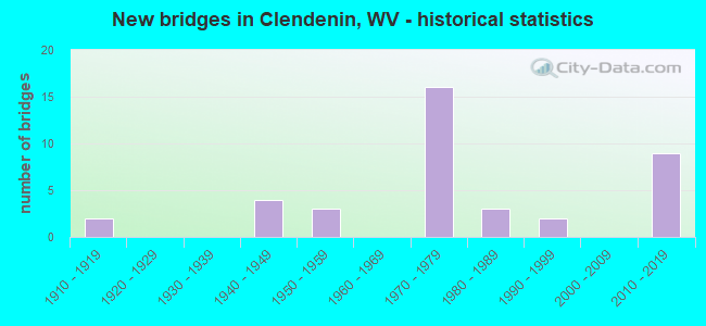
- New bridges - historical statistics
- 21910-1919
- 41940-1949
- 31950-1959
- 161970-1979
- 31980-1989
- 21990-1999
- 92010-2019

- Reconstructed bridges - Historical Statistics
- 21980-1989
- 11990-1999


- Bridge Condition - Deck
- 22.6%Very good
- 19.4%Good
- 16.1%Satisfactory
- 29.0%Fair
- 9.7%Poor
- 3.2%Critical

- Bridge Condition - Superstructure
- 18.2%Very good
- 24.2%Good
- 27.3%Satisfactory
- 21.2%Fair
- 6.1%Poor
- 3.0%Serious

- Bridge Condition - Substructure
- 21.2%Very good
- 21.2%Good
- 27.3%Satisfactory
- 27.3%Fair
- 3.0%Poor

- Bridge Condition - Channel
- 6.3%Excellent
- 28.1%Very good
- 15.6%Good
- 31.3%Satisfactory
- 18.8%Fair
Find on map >> Show street view
Structure Number: 8A003, Location: 0.04 MI N OF CR 1/5 (Lat: 38.471811, Lng: -81.283700), Route carried "on" structure: County highway 1, Year Built: 1981, Status: Open, Structure Length: 11.33m (37.17ft), Average Daily Traffic: 500 (year 2020), Truck Traffic: 8%, Average Future Daily Traffic: 805 (year 2040), Design Load: HS 20, Features Intersected: ELK RIVER
Minimum Vertical Clearance: 30+ m (98+ ft), Kilometerpoint: 27.423, Lanes on structure: 2, Owner: State Highway Agency, Approaching Roadway Width: 7.0m (23.0ft), Material/Design: Steel continuous, Design/Construction: Stringer/Multi-beam, Number Of Spans In Main Unit: 1, Number Of Approach Spans: 2, Length of Maximum Span: 42.7m (140.1ft), Curb or Sidewalk Widths: Left: 0.0m, Right: 1.2m (3.9ft), Curb-To-Curb Width: 7.6m (24.9ft), Out-to-Out Width: 10.2m (33.5ft)
Condition: Deck: Satisfactory, Superstructure: Satisfactory, Substructure: Fair, Channel: Very good, Operating Rating: 87.1 metric tons, Method Used To Determine Operating Rating: Load Factor (LF), Inventory Rating: 51.7 metric tons, Method Used To Determine Inventory Rating: Load Factor (LF), Structural Evaluation: Somewhat better than minimum adequacy, Deck Geometry: Meets minimum limits, Waterway Adequacy: Superior to present desirable criteria, Approach Roadway Alignment: Somewhat better than minimum adequacy, Length Of Structure Improvement: 11.33m (37.17ft), Designated Inspection Frequency: Every 24 months, Underwater Inspection Frequency: Every 60 months, Inspection Date: June 2021, Underwater Inspection Date: June 2020, Bridge Improvement Cost: $650,000, Roadway Improvement Cost: $100,000, Total Project Cost: $750,000 ( Estimate for 2021), Deck Structure Type: Concrete Cast-file-Place, Wearing Surface/Protective System: Wearing Surface: Integral Concrete, Deck Protection: Epoxy Coated Reinforcing
Find on map >> Show street view
Structure Number: 8A127, Location: 0.11 MI S OF CR 1 (Lat: 38.469550, Lng: -81.282900), Route carried "on" structure: County highway 15, Year Built: 2017, Status: Open, Structure Length: 1.77m (5.81ft), Average Daily Traffic: 30 (year 2020), Truck Traffic: 10%, Average Future Daily Traffic: 37 (year 2040), Design Load: HL 93, Features Intersected: QUEEN SHOALS CREEK, Facility Carried by Structure: CR 1/5
Minimum Vertical Clearance: 30+ m (98+ ft), Kilometerpoint: 0.370, Lanes on structure: 1, Owner: State Highway Agency, Approaching Roadway Width: 4.9m (16.1ft), Skew: 1 degrees, Material/Design: Steel, Design/Construction: Stringer/Multi-beam, Number Of Spans In Main Unit: 1, Length of Maximum Span: 17.7m (58.1ft), Curb or Sidewalk Widths: Left: 0.5m (1.6ft), Right: 0.5m (1.6ft), Curb-To-Curb Width: 4.7m (15.4ft), Out-to-Out Width: 5.9m (19.4ft)
Condition: Deck: Very good, Superstructure: Very good, Substructure: Very good, Channel: Fair, Operating Rating: 62.6 metric tons, Method Used To Determine Operating Rating: Load and Resistance Factor (LRFR), Inventory Rating: 48.1 metric tons, Method Used To Determine Inventory Rating: Load and Resistance Factor (LRFR), Structural Evaluation: Equal to present desirable criteria, Deck Geometry: Better than present minimum criteria, Waterway Adequacy: Better than present minimum criteria, Approach Roadway Alignment: Equal to present minimum criteria, Designated Inspection Frequency: Every 24 months, Inspection Date: June 2021, Deck Structure Type: Concrete Cast-file-Place, Wearing Surface/Protective System: Wearing Surface: Latex Concrete, Deck Protection: Epoxy Coated Reinforcing
Find on map >> Show street view
Structure Number: 20A006, Location: 0.01 MI. N. OF US 119 T (Lat: 38.490331, Lng: -81.349350), Route carried "on" structure: State highway 400, Year Built: 1993, Status: Open, Structure Length: 5.73m (18.80ft), Average Daily Traffic: 3,032 (year 2017), Truck Traffic: 6%, Average Future Daily Traffic: 5,146 (year 2037), Design Load: HS 25 or greater, Features Intersected: BIG SANDY CREEK, Facility Carried by Structure: WV 4
Minimum Vertical Clearance: 30+ m (98+ ft), Kilometerpoint: 0.016, Lanes on structure: 2, Owner: State Highway Agency, Approaching Roadway Width: 9.1m (29.9ft), Material/Design: Prestressed concrete, Design/Construction: Stringer/Multi-beam, Number Of Spans In Main Unit: 1, Number Of Approach Spans: 2, Length of Maximum Span: 22.3m (73.2ft), Curb or Sidewalk Widths: Left: 1.5m (4.9ft), Right: 1.5m (4.9ft), Curb-To-Curb Width: 9.1m (29.9ft), Out-to-Out Width: 12.8m (42.0ft)
Condition: Deck: Satisfactory, Superstructure: Good, Substructure: Very good, Channel: Satisfactory, Operating Rating: 49.9 metric tons, Method Used To Determine Operating Rating: Load Factor (LF), Inventory Rating: 30.8 metric tons, Method Used To Determine Inventory Rating: Load Factor (LF), Structural Evaluation: Better than present minimum criteria, Deck Geometry: Meets minimum limits, Waterway Adequacy: Equal to present desirable criteria, Approach Roadway Alignment: Better than present minimum criteria, Designated Inspection Frequency: Every 48 months, Inspection Date: June 2019, Deck Structure Type: Concrete Cast-file-Place, Wearing Surface/Protective System: Wearing Surface: Monolithic Concrete, Deck Protection: Epoxy Coated Reinforcing
Find on map >> Show street view
Structure Number: 20A138, Location: 3.67 MI N OF CR 58/2 (Lat: 38.460281, Lng: -81.387211), Route carried "on" structure: County highway 58, Year Built: 1978, Status: Posted for load, Structure Length: 1.87m (6.14ft), Average Daily Traffic: 10 (year 2020), Truck Traffic: 5%, Average Future Daily Traffic: 14 (year 2040), Design Load: H 20, Features Intersected: FALLING ROCK CREEK
Minimum Vertical Clearance: 30+ m (98+ ft), Kilometerpoint: 8.336, Lanes on structure: 1, Owner: State Highway Agency, Approaching Roadway Width: 4.6m (15.1ft), Skew: 1 degrees, Material/Design: Steel, Design/Construction: Stringer/Multi-beam, Number Of Spans In Main Unit: 1, Length of Maximum Span: 17.8m (58.4ft), Curb-To-Curb Width: 4.6m (15.1ft), Out-to-Out Width: 4.7m (15.4ft)
Condition: Deck: Fair, Superstructure: Fair, Substructure: Fair, Channel: Satisfactory, Operating Rating: 36.3 metric tons, Method Used To Determine Operating Rating: Load Factor (LF), Inventory Rating: 21.8 metric tons, Method Used To Determine Inventory Rating: Load Factor (LF), Structural Evaluation: Somewhat better than minimum adequacy, Deck Geometry: Better than present minimum criteria, Waterway Adequacy: Better than present minimum criteria, Approach Roadway Alignment: Equal to present minimum criteria, Bridge Posting: Required (Relationship of Operating Rating to Maximum Legal Load: 10.0 - 19.9% below), Length Of Structure Improvement: 1.87m (6.14ft), Designated Inspection Frequency: Every 24 months, Other Special Inspection Frequency: Every 12 months, Inspection Date: August 2020, Other Special Inspection Date: September 2021, Bridge Improvement Cost: $400,000, Roadway Improvement Cost: $50,000, Total Project Cost: $450,000 ( Estimate for 2020), Deck Structure Type: Wood or Timber, Wearing Surface/Protective System: Wearing Surface: Wood or Timber
Find on map >> Show street view
Structure Number: 20A14, Location: 0.01 MI N OF US 119 (Lat: 38.499561, Lng: -81.347989), Route carried "on" structure: County highway 59, Year Built: 1977, Status: Open, Structure Length: 5.34m (17.52ft), Average Daily Traffic: 900 (year 2020), Truck Traffic: 5%, Average Future Daily Traffic: 1,179 (year 2040), Design Load: HS 20, Features Intersected: BIG SANDY CREEK
Minimum Vertical Clearance: 30+ m (98+ ft), Kilometerpoint: 0.016, Lanes on structure: 2, Owner: State Highway Agency, Approaching Roadway Width: 6.7m (22.0ft), Material/Design: Steel continuous, Design/Construction: Stringer/Multi-beam, Number Of Spans In Main Unit: 1, Number Of Approach Spans: 2, Length of Maximum Span: 19.8m (65.0ft), Curb-To-Curb Width: 7.3m (24.0ft), Out-to-Out Width: 8.5m (27.9ft)
Condition: Deck: Satisfactory, Superstructure: Satisfactory, Substructure: Fair, Channel: Fair, Operating Rating: 55.3 metric tons, Method Used To Determine Operating Rating: Load Factor (LF), Inventory Rating: 32.7 metric tons, Method Used To Determine Inventory Rating: Load Factor (LF), Structural Evaluation: Somewhat better than minimum adequacy, Deck Geometry: Meets minimum limits, Waterway Adequacy: Better than present minimum criteria, Approach Roadway Alignment: Equal to present desirable criteria, Length Of Structure Improvement: 5.34m (17.52ft), Designated Inspection Frequency: Every 24 months, Inspection Date: December 2021, Bridge Improvement Cost: $200,000, Roadway Improvement Cost: $50,000, Total Project Cost: $250,000 ( Estimate for 2019), Deck Structure Type: Concrete Cast-file-Place, Wearing Surface/Protective System: Wearing Surface: Latex Concrete
Find on map >> Show street view
Structure Number: 20A141, Location: 0.01 MI S OF CR 64/2 (Lat: 38.527200, Lng: -81.308089), Route carried "on" structure: County highway 59, Year Built: 1947, Status: Posted for load, Structure Length: 1.38m (4.53ft), Average Daily Traffic: 150 (year 2020), Truck Traffic: 5%, Average Future Daily Traffic: 197 (year 2040), Features Intersected: LITTLE BLUE CREEK
Minimum Vertical Clearance: 30+ m (98+ ft), Kilometerpoint: 7.451, Lanes on structure: 2, Owner: State Highway Agency, Approaching Roadway Width: 4.9m (16.1ft), Material/Design: Steel, Design/Construction: Stringer/Multi-beam, Number Of Spans In Main Unit: 1, Length of Maximum Span: 12.8m (42.0ft), Curb or Sidewalk Widths: Left: 0.2m (0.7ft), Right: 0.2m (0.7ft), Curb-To-Curb Width: 5.5m (18.0ft), Out-to-Out Width: 5.9m (19.4ft)
Condition: Deck: Poor, Superstructure: Poor, Substructure: Satisfactory, Channel: Satisfactory, Operating Rating: 19.0 metric tons, Method Used To Determine Operating Rating: Load Factor (LF), Inventory Rating: 10.9 metric tons, Method Used To Determine Inventory Rating: Load Factor (LF), Structural Evaluation: Meets minimum limits, Deck Geometry: High priority of corrective action, Waterway Adequacy: Better than present minimum criteria, Approach Roadway Alignment: Somewhat better than minimum adequacy, Bridge Posting: Required (Relationship of Operating Rating to Maximum Legal Load: > 39.9% below), Length Of Structure Improvement: 1.83m (6.00ft), Designated Inspection Frequency: Every 24 months, Other Special Inspection Frequency: Every 12 months, Inspection Date: July 2020, Other Special Inspection Date: August 2021, Bridge Improvement Cost: $500,000, Roadway Improvement Cost: $100,000, Total Project Cost: $600,000 ( Estimate for 2020), Deck Structure Type: Concrete Cast-file-Place, Wearing Surface/Protective System: Wearing Surface: Bituminous
Find on map >> Show street view
Structure Number: 20A189, Location: 0.01 MI S OF CR 58 (Lat: 38.467631, Lng: -81.399181), Route carried "on" structure: County highway 63, Year Built: 1951, Status: Open, Structure Length: 4.60m (15.09ft), Average Daily Traffic: 250 (year 2018), Truck Traffic: 5%, Average Future Daily Traffic: 305 (year 2038), Features Intersected: FALLING ROCK CREEK
Minimum Vertical Clearance: 30+ m (98+ ft), Kilometerpoint: 5.198, Lanes on structure: 1, Owner: State Highway Agency, Approaching Roadway Width: 4.9m (16.1ft), Material/Design: Steel, Design/Construction: Stringer/Multi-beam, Number Of Spans In Main Unit: 3, Length of Maximum Span: 14.6m (47.9ft), Curb or Sidewalk Widths: Left: 1.0m (3.3ft), Right: 1.0m (3.3ft), Curb-To-Curb Width: 4.3m (14.1ft), Out-to-Out Width: 4.8m (15.7ft)
Condition: Deck: Fair, Superstructure: Fair, Substructure: Fair, Channel: Satisfactory, Operating Rating: 60.8 metric tons, Method Used To Determine Operating Rating: Load Factor (LF), Inventory Rating: 36.3 metric tons, Method Used To Determine Inventory Rating: Load Factor (LF), Structural Evaluation: Somewhat better than minimum adequacy, Deck Geometry: High priority of replacement, Waterway Adequacy: Superior to present desirable criteria, Approach Roadway Alignment: Better than present minimum criteria, Length Of Structure Improvement: 4.60m (15.09ft), Designated Inspection Frequency: Every 24 months, Critical Feature Inspection Frequency: Every 24 months, Inspection Date: June 2020, Critical Feature Inspection Date: June 2020, Bridge Improvement Cost: $750,000, Roadway Improvement Cost: $50,000, Total Project Cost: $800,000 ( Estimate for 2020), Deck Structure Type: Concrete Cast-file-Place, Wearing Surface/Protective System: Wearing Surface: Monolithic Concrete
Find on map >> Show street view
Structure Number: 20A19, Location: 0.08 MI S OF CR 65 (Lat: 38.473300, Lng: -81.377289), Route carried "on" structure: County highway 63, Year Built: 1979, Status: Open, Structure Length: 4.13m (13.55ft), Average Daily Traffic: 300 (year 2018), Truck Traffic: 5%, Average Future Daily Traffic: 366 (year 2038), Design Load: HS 20, Features Intersected: LEATHERWOOD CREEK
Minimum Vertical Clearance: 30+ m (98+ ft), Kilometerpoint: 7.323, Lanes on structure: 2, Owner: State Highway Agency, Approaching Roadway Width: 5.5m (18.0ft), Material/Design: Steel continuous, Design/Construction: Stringer/Multi-beam, Number Of Spans In Main Unit: 2, Length of Maximum Span: 19.8m (65.0ft), Curb-To-Curb Width: 7.3m (24.0ft), Out-to-Out Width: 8.4m (27.6ft)
Condition: Deck: Fair, Superstructure: Satisfactory, Substructure: Satisfactory, Channel: Good, Operating Rating: 71.7 metric tons, Method Used To Determine Operating Rating: Load Factor (LF), Inventory Rating: 42.6 metric tons, Method Used To Determine Inventory Rating: Load Factor (LF), Structural Evaluation: Equal to present minimum criteria, Deck Geometry: Somewhat better than minimum adequacy, Waterway Adequacy: Superior to present desirable criteria, Approach Roadway Alignment: Equal to present desirable criteria, Designated Inspection Frequency: Every 24 months, Inspection Date: March 2020, Deck Structure Type: Concrete Cast-file-Place, Wearing Surface/Protective System: Wearing Surface: Monolithic Concrete, Deck Protection: Epoxy Coated Reinforcing
Find on map >> Show street view
Structure Number: 20A198, Location: 0.23 MI E OF CR 59 (Lat: 38.525869, Lng: -81.304161), Route carried "on" structure: County highway 642, Year Built: 1984, Status: Posted for load, Structure Length: 1.51m (4.95ft), Average Daily Traffic: 30 (year 2018), Truck Traffic: 5%, Average Future Daily Traffic: 37 (year 2038), Design Load: H 20, Features Intersected: LITTLE BLUE CREEK, Facility Carried by Structure: CR 64/2
Minimum Vertical Clearance: 30+ m (98+ ft), Kilometerpoint: 0.370, Lanes on structure: 1, Owner: State Highway Agency, Approaching Roadway Width: 4.6m (15.1ft), Skew: 3 degrees, Material/Design: Steel, Design/Construction: Girder and Floorbeam System, Number Of Spans In Main Unit: 1, Length of Maximum Span: 13.7m (44.9ft), Curb or Sidewalk Widths: Left: 0.1m (0.3ft), Right: 0.1m (0.3ft), Curb-To-Curb Width: 4.8m (15.7ft), Out-to-Out Width: 4.8m (15.7ft)
Condition: Deck: Satisfactory, Superstructure: Fair, Substructure: Fair, Channel: Satisfactory, Operating Rating: 34.5 metric tons, Method Used To Determine Operating Rating: Load Factor (LF), Inventory Rating: 20.9 metric tons, Method Used To Determine Inventory Rating: Load Factor (LF), Structural Evaluation: Somewhat better than minimum adequacy, Deck Geometry: Equal to present desirable criteria, Waterway Adequacy: Meets minimum limits, Approach Roadway Alignment: Equal to present minimum criteria, Bridge Posting: Required (Relationship of Operating Rating to Maximum Legal Load: 20.0 - 29.9% below), Length Of Structure Improvement: 1.51m (4.95ft), Designated Inspection Frequency: Every 24 months, Critical Feature Inspection Frequency: Every 24 months, Inspection Date: October 2020, Critical Feature Inspection Date: October 2020, Bridge Improvement Cost: $500,000, Roadway Improvement Cost: $50,000, Total Project Cost: $550,000 ( Estimate for 2021), Deck Structure Type: Wood or Timber, Wearing Surface/Protective System: Wearing Surface: Bituminous
Find on map >> Show street view
Structure Number: 20A201, Location: 0.61 MI N OF PR 65/3 (Lat: 38.458711, Lng: -81.360489), Route carried "on" structure: County highway 65, Year Built: 1989, Status: Open, Structure Length: 2.18m (7.15ft), Average Daily Traffic: 100 (year 2018), Truck Traffic: 5%, Average Future Daily Traffic: 122 (year 2036), Design Load: HS 25 or greater, Features Intersected: LEATHERWOOD CREEK
Minimum Vertical Clearance: 30+ m (98+ ft), Kilometerpoint: 14.211, Lanes on structure: 2, Owner: State Highway Agency, Approaching Roadway Width: 5.2m (17.1ft), Material/Design: Prestressed concrete, Design/Construction: Box Beam or Girders - Multiple, Number Of Spans In Main Unit: 1, Length of Maximum Span: 21.3m (69.9ft), Curb-To-Curb Width: 6.4m (21.0ft), Out-to-Out Width: 6.5m (21.3ft)
Condition: Deck: Good, Superstructure: Satisfactory, Substructure: Very good, Channel: Fair, Operating Rating: 88.9 metric tons, Method Used To Determine Operating Rating: Load Factor (LF), Inventory Rating: 55.3 metric tons, Method Used To Determine Inventory Rating: Load Factor (LF), Structural Evaluation: Equal to present minimum criteria, Deck Geometry: Somewhat better than minimum adequacy, Waterway Adequacy: Equal to present desirable criteria, Approach Roadway Alignment: Better than present minimum criteria, Designated Inspection Frequency: Every 24 months, Inspection Date: September 2020, Deck Structure Type: Other, Wearing Surface/Protective System: Wearing Surface: Monolithic Concrete, Deck Protection: Epoxy Coated Reinforcing
Find on map >> Show street view
Structure Number: 20A202, Location: 0.01 MI S OF CR 63/3 (Lat: 38.468961, Lng: -81.364719), Route carried "on" structure: County highway 65, Year Built: 1946, Year Reconstructed: 1986, Status: Open, Structure Length: 1.20m (3.94ft), Average Daily Traffic: 100 (year 2018), Truck Traffic: 5%, Average Future Daily Traffic: 122 (year 2038), Design Load: HS 20, Features Intersected: LEFT FK LEATHERWOOD CK
Minimum Vertical Clearance: 30+ m (98+ ft), Kilometerpoint: 15.562, Lanes on structure: 2, Owner: State Highway Agency, Approaching Roadway Width: 4.3m (14.1ft), Skew: 3 degrees, Material/Design: Steel, Design/Construction: Stringer/Multi-beam, Number Of Spans In Main Unit: 1, Length of Maximum Span: 10.4m (34.1ft), Curb-To-Curb Width: 6.3m (20.7ft), Out-to-Out Width: 6.6m (21.7ft)
Condition: Deck: Poor, Superstructure: Fair, Substructure: Good, Channel: Satisfactory, Operating Rating: 88.9 metric tons, Method Used To Determine Operating Rating: Load Factor (LF), Inventory Rating: 71.7 metric tons, Method Used To Determine Inventory Rating: Load Factor (LF), Structural Evaluation: Somewhat better than minimum adequacy, Deck Geometry: Somewhat better than minimum adequacy, Waterway Adequacy: Equal to present desirable criteria, Approach Roadway Alignment: Meets minimum limits, Length Of Structure Improvement: 1.20m (3.94ft), Designated Inspection Frequency: Every 24 months, Inspection Date: Febuary 2021, Bridge Improvement Cost: $500,000, Roadway Improvement Cost: $50,000, Total Project Cost: $550,000 ( Estimate for 2021), Deck Structure Type: Open Grating, Wearing Surface/Protective System: Wearing Surface: Other
Find on map >> Show street view
Structure Number: 20A287, Location: 0.01 MI N OF US 119 (Lat: 38.530689, Lng: -81.339489), Route carried "on" structure: County highway 1193, Year Built: 1940, Year Reconstructed: 1988, Status: Open, Structure Length: 1.57m (5.15ft), Average Daily Traffic: 50 (year 2018), Truck Traffic: 5%, Average Future Daily Traffic: 61 (year 2038), Design Load: HS 20+Mod, Features Intersected: LEFTHAND CREEK, Facility Carried by Structure: COUNTY ROUTE 119/3
Minimum Vertical Clearance: 30+ m (98+ ft), Kilometerpoint: 0.016, Lanes on structure: 2, Owner: State Highway Agency, Approaching Roadway Width: 5.2m (17.1ft), Material/Design: Prestressed concrete, Design/Construction: Box Beam or Girders - Multiple, Number Of Spans In Main Unit: 1, Length of Maximum Span: 15.2m (49.9ft), Curb-To-Curb Width: 5.2m (17.1ft), Out-to-Out Width: 5.5m (18.0ft)
Condition: Deck: Fair, Superstructure: Fair, Substructure: Satisfactory, Channel: Good, Operating Rating: 87.1 metric tons, Method Used To Determine Operating Rating: Load Factor (LF), Inventory Rating: 52.6 metric tons, Method Used To Determine Inventory Rating: Load Factor (LF), Structural Evaluation: Somewhat better than minimum adequacy, Deck Geometry: High priority of corrective action, Waterway Adequacy: Equal to present desirable criteria, Approach Roadway Alignment: Equal to present minimum criteria, Designated Inspection Frequency: Every 24 months, Inspection Date: August 2020, Deck Structure Type: Other, Wearing Surface/Protective System: Wearing Surface: Monolithic Concrete, Deck Protection: Epoxy Coated Reinforcing
Find on map >> Show street view
Structure Number: 20A51, Location: 5.78 MI. N. OF CR 43 (Lat: 38.501361, Lng: -81.414750), Route carried "on" structure: Interstate 79, Year Built: 1976, Status: Open, Structure Length: 13.65m (44.78ft), Average Daily Traffic: 12,700 (year 2020), Truck Traffic: 17%, Average Future Daily Traffic: 19,812 (year 2040), Design Load: HS 20+Mod, Features Intersected: CR 53 & WILLS CREEK
Minimum Vertical Clearance: 30+ m (98+ ft), Kilometerpoint: 24.880, Lanes on structure: 2, Lanes under structure: 2, Base Highway Network: Yes, Owner: State Highway Agency, Approaching Roadway Width: 11.9m (39.0ft), Material/Design: Steel continuous, Design/Construction: Stringer/Multi-beam, Number Of Spans In Main Unit: 1, Number Of Approach Spans: 3, Length of Maximum Span: 38.7m (127.0ft), Curb-To-Curb Width: 12.3m (40.4ft), Out-to-Out Width: 13.6m (44.6ft)
Condition: Deck: Satisfactory, Superstructure: Satisfactory, Substructure: Satisfactory, Channel: Satisfactory, Operating Rating: 60.8 metric tons, Method Used To Determine Operating Rating: Load Factor (LF), Inventory Rating: 36.3 metric tons, Method Used To Determine Inventory Rating: Load Factor (LF), Structural Evaluation: Equal to present minimum criteria, Deck Geometry: Better than present minimum criteria, Underclear: Better than present minimum criteria, Waterway Adequacy: Superior to present desirable criteria, Approach Roadway Alignment: Equal to present desirable criteria, Length Of Structure Improvement: 13.65m (44.78ft), Designated Inspection Frequency: Every 24 months, Inspection Date: August 2021, Bridge Improvement Cost: $300,000, Roadway Improvement Cost: $50,000, Total Project Cost: $350,000 ( Estimate for 2019), Deck Structure Type: Concrete Cast-file-Place, Wearing Surface/Protective System: Wearing Surface: Latex Concrete
Find on map >> Show street view
Structure Number: 20A511, Location: 5.78 MI. N. OF CR 43 (Lat: 38.501211, Lng: -81.415189), Route carried "on" structure: Interstate 79, Year Built: 1976, Status: Open, Structure Length: 16.45m (53.97ft), Average Daily Traffic: 6,350 (year 2020), Truck Traffic: 17%, Average Future Daily Traffic: 9,906 (year 2040), Design Load: HS 20+Mod, Features Intersected: CR 53 & WILLS CREEK
Minimum Vertical Clearance: 30+ m (98+ ft), Kilometerpoint: 24.880, Lanes on structure: 2, Lanes under structure: 2, Base Highway Network: Yes, Owner: State Highway Agency, Approaching Roadway Width: 11.9m (39.0ft), Material/Design: Steel continuous, Design/Construction: Stringer/Multi-beam, Number Of Spans In Main Unit: 1, Number Of Approach Spans: 3, Length of Maximum Span: 45.0m (147.6ft), Curb-To-Curb Width: 12.3m (40.4ft), Out-to-Out Width: 13.6m (44.6ft)
Condition: Deck: Fair, Superstructure: Fair, Substructure: Satisfactory, Channel: Excellent, Operating Rating: 71.7 metric tons, Method Used To Determine Operating Rating: Load Factor (LF), Inventory Rating: 42.6 metric tons, Method Used To Determine Inventory Rating: Load Factor (LF), Structural Evaluation: Somewhat better than minimum adequacy, Deck Geometry: Better than present minimum criteria, Underclear: Equal to present minimum criteria, Waterway Adequacy: Superior to present desirable criteria, Approach Roadway Alignment: Equal to present desirable criteria, Length Of Structure Improvement: 16.45m (53.97ft), Designated Inspection Frequency: Every 24 months, Inspection Date: August 2021, Bridge Improvement Cost: $300,000, Roadway Improvement Cost: $50,000, Total Project Cost: $350,000 ( Estimate for 2019), Deck Structure Type: Concrete Cast-file-Place, Wearing Surface/Protective System: Wearing Surface: Latex Concrete
Find on map >> Show street view
Structure Number: 20A512, Location: 6.29 MI. N. OF CR 43 (Lat: 38.507089, Lng: -81.409600), Route carried "on" structure: Interstate 79, Year Built: 1976, Status: Open, Structure Length: 11.35m (37.24ft), Average Daily Traffic: 7,482 (year 2017), Truck Traffic: 21%, Average Future Daily Traffic: 10,550 (year 2038), Design Load: HS 20+Mod, Features Intersected: CR 53 & GABES CREEK
Minimum Vertical Clearance: 30+ m (98+ ft), Kilometerpoint: 25.701, Lanes on structure: 2, Lanes under structure: 2, Base Highway Network: Yes, Owner: State Highway Agency, Approaching Roadway Width: 12.2m (40.0ft), Skew: 9 degrees, Material/Design: Prestressed concrete, Design/Construction: Stringer/Multi-beam, Number Of Spans In Main Unit: 1, Number Of Approach Spans: 4, Length of Maximum Span: 23.2m (76.1ft), Curb-To-Curb Width: 12.3m (40.4ft), Out-to-Out Width: 13.6m (44.6ft)
Condition: Deck: Poor, Superstructure: Satisfactory, Substructure: Fair, Channel: Very good, Operating Rating: 72.6 metric tons, Method Used To Determine Operating Rating: Load Factor (LF), Inventory Rating: 43.5 metric tons, Method Used To Determine Inventory Rating: Load Factor (LF), Structural Evaluation: Somewhat better than minimum adequacy, Deck Geometry: Better than present minimum criteria, Underclear: Meets minimum limits, Waterway Adequacy: Superior to present desirable criteria, Approach Roadway Alignment: Equal to present desirable criteria, Length Of Structure Improvement: 11.35m (37.24ft), Designated Inspection Frequency: Every 24 months, Inspection Date: March 2021, Bridge Improvement Cost: $650,000, Roadway Improvement Cost: $50,000, Total Project Cost: $700,000 ( Estimate for 2021), Deck Structure Type: Concrete Cast-file-Place, Wearing Surface/Protective System: Wearing Surface: Latex Concrete
Find on map >> Show street view
Structure Number: 20A513, Location: 6.29 MI. N. OF CR 43 (Lat: 38.507369, Lng: -81.409419), Route carried "on" structure: Interstate 79, Year Built: 1976, Status: Open, Structure Length: 8.82m (28.94ft), Average Daily Traffic: 7,850 (year 2019), Truck Traffic: 21%, Average Future Daily Traffic: 11,069 (year 2039), Design Load: HS 20+Mod, Features Intersected: CR 53 & GABES CREEK
Minimum Vertical Clearance: 30+ m (98+ ft), Kilometerpoint: 25.701, Lanes on structure: 2, Lanes under structure: 2, Base Highway Network: Yes, Owner: State Highway Agency, Approaching Roadway Width: 12.2m (40.0ft), Skew: 9 degrees, Material/Design: Prestressed concrete, Design/Construction: Stringer/Multi-beam, Number Of Spans In Main Unit: 3, Number Of Approach Spans: 1, Length of Maximum Span: 22.0m (72.2ft), Curb-To-Curb Width: 12.3m (40.4ft), Out-to-Out Width: 13.6m (44.6ft)
Condition: Deck: Fair, Superstructure: Good, Substructure: Fair, Channel: Very good, Operating Rating: 78.0 metric tons, Method Used To Determine Operating Rating: Load Factor (LF), Inventory Rating: 46.3 metric tons, Method Used To Determine Inventory Rating: Load Factor (LF), Structural Evaluation: Somewhat better than minimum adequacy, Deck Geometry: Better than present minimum criteria, Underclear: Equal to present minimum criteria, Waterway Adequacy: Superior to present desirable criteria, Approach Roadway Alignment: Equal to present desirable criteria, Length Of Structure Improvement: 8.82m (28.94ft), Designated Inspection Frequency: Every 24 months, Inspection Date: April 2021, Bridge Improvement Cost: $550,000, Roadway Improvement Cost: $50,000, Total Project Cost: $600,000 ( Estimate for 2021), Deck Structure Type: Concrete Cast-file-Place, Wearing Surface/Protective System: Wearing Surface: Latex Concrete
Find on map >> Show street view
Structure Number: 20A514, Location: 9.54 MI N OF CR 43 (Lat: 38.519019, Lng: -81.357800), Route carried "on" structure: Interstate 79, Year Built: 1977, Status: Open, Structure Length: 6.67m (21.88ft), Average Daily Traffic: 5,800 (year 2020), Truck Traffic: 17%, Average Future Daily Traffic: 9,048 (year 2040), Design Load: HS 20+Mod, Features Intersected: CR 53
Minimum Vertical Clearance: 30+ m (98+ ft), Kilometerpoint: 30.932, Lanes on structure: 2, Lanes under structure: 2, Base Highway Network: Yes, Owner: State Highway Agency, Approaching Roadway Width: 12.8m (42.0ft), Skew: 3 degrees, Material/Design: Steel continuous, Design/Construction: Stringer/Multi-beam, Number Of Spans In Main Unit: 1, Number Of Approach Spans: 2, Length of Maximum Span: 27.7m (90.9ft), Curb-To-Curb Width: 12.3m (40.4ft), Out-to-Out Width: 13.6m (44.6ft)
Condition: Deck: Fair, Superstructure: Good, Substructure: Satisfactory, Operating Rating: 88.9 metric tons, Method Used To Determine Operating Rating: Load Factor (LF), Inventory Rating: 53.5 metric tons, Method Used To Determine Inventory Rating: Load Factor (LF), Structural Evaluation: Equal to present minimum criteria, Deck Geometry: Better than present minimum criteria, Underclear: Somewhat better than minimum adequacy, Approach Roadway Alignment: Equal to present desirable criteria, Length Of Structure Improvement: 6.67m (21.88ft), Designated Inspection Frequency: Every 24 months, Inspection Date: September 2021, Bridge Improvement Cost: $350,000, Roadway Improvement Cost: $100,000, Total Project Cost: $450,000 ( Estimate for 2019), Deck Structure Type: Concrete Cast-file-Place, Wearing Surface/Protective System: Wearing Surface: Monolithic Concrete, Deck Protection: Epoxy Coated Reinforcing
Find on map >> Show street view
Structure Number: 20A515, Location: 9.54 MI N OF CR 43 (Lat: 38.519231, Lng: -81.357881), Route carried "on" structure: Interstate 79, Year Built: 1977, Status: Open, Structure Length: 6.67m (21.88ft), Average Daily Traffic: 11,600 (year 2020), Truck Traffic: 21%, Average Future Daily Traffic: 14,152 (year 2040), Design Load: HS 20+Mod, Features Intersected: CR 53
Minimum Vertical Clearance: 30+ m (98+ ft), Kilometerpoint: 30.932, Lanes on structure: 2, Lanes under structure: 2, Base Highway Network: Yes, Owner: State Highway Agency, Approaching Roadway Width: 12.5m (41.0ft), Skew: 3 degrees, Material/Design: Steel continuous, Design/Construction: Stringer/Multi-beam, Number Of Spans In Main Unit: 1, Number Of Approach Spans: 2, Length of Maximum Span: 27.7m (90.9ft), Curb-To-Curb Width: 12.3m (40.4ft), Out-to-Out Width: 13.6m (44.6ft)
Condition: Deck: Fair, Superstructure: Good, Substructure: Satisfactory, Operating Rating: 67.1 metric tons, Method Used To Determine Operating Rating: Load Factor (LF), Inventory Rating: 39.9 metric tons, Method Used To Determine Inventory Rating: Load Factor (LF), Structural Evaluation: Equal to present minimum criteria, Deck Geometry: Better than present minimum criteria, Underclear: Somewhat better than minimum adequacy, Approach Roadway Alignment: Equal to present desirable criteria, Length Of Structure Improvement: 6.67m (21.88ft), Designated Inspection Frequency: Every 24 months, Inspection Date: June 2021, Bridge Improvement Cost: $550,000, Roadway Improvement Cost: $100,000, Total Project Cost: $650,000 ( Estimate for 2019), Deck Structure Type: Concrete Cast-file-Place, Wearing Surface/Protective System: Wearing Surface: Monolithic Concrete, Deck Protection: Epoxy Coated Reinforcing
Find on map >> Show street view
Structure Number: 20A535, Location: 0.01 MI E OF US 119 (Lat: 38.488181, Lng: -81.352911), Route carried "on" structure: County highway 11910, Year Built: 1977, Status: Open, Structure Length: 10.84m (35.56ft), Average Daily Traffic: 4,800 (year 2017), Truck Traffic: 5%, Average Future Daily Traffic: 5,856 (year 2037), Design Load: HS 20, Features Intersected: ELK RIVER, Facility Carried by Structure: CR 119/10
Minimum Vertical Clearance: 30+ m (98+ ft), Kilometerpoint: 0.016, Lanes on structure: 2, Owner: State Highway Agency, Approaching Roadway Width: 9.1m (29.9ft), Material/Design: Steel continuous, Design/Construction: Stringer/Multi-beam, Number Of Spans In Main Unit: 1, Number Of Approach Spans: 2, Length of Maximum Span: 42.7m (140.1ft), Curb or Sidewalk Widths: Left: 0.0m, Right: 1.5m (4.9ft), Curb-To-Curb Width: 9.1m (29.9ft), Out-to-Out Width: 12.1m (39.7ft)
Condition: Deck: Fair, Superstructure: Satisfactory, Substructure: Fair, Channel: Very good, Operating Rating: 68.9 metric tons, Method Used To Determine Operating Rating: Load Factor (LF), Inventory Rating: 40.8 metric tons, Method Used To Determine Inventory Rating: Load Factor (LF), Structural Evaluation: Somewhat better than minimum adequacy, Deck Geometry: Meets minimum limits, Waterway Adequacy: Superior to present desirable criteria, Approach Roadway Alignment: Equal to present desirable criteria, Length Of Structure Improvement: 10.85m (35.60ft), Designated Inspection Frequency: Every 24 months, Inspection Date: May 2020, Bridge Improvement Cost: $600,000, Roadway Improvement Cost: $50,000, Total Project Cost: $650,000 ( Estimate for 2020), Deck Structure Type: Concrete Cast-file-Place, Wearing Surface/Protective System: Wearing Surface: Monolithic Concrete, Deck Protection: Epoxy Coated Reinforcing
Find on map >> Show street view
Structure Number: 20A718, Location: 0.98 MI N OF US 119 (T) (Lat: 38.507611, Lng: -81.335381), Route carried "on" structure: County highway 59, Year Built: 1940, Status: Open, Structure Length: 0.87m (2.85ft), Average Daily Traffic: 1,600 (year 2018), Truck Traffic: 5%, Average Future Daily Traffic: 1,952 (year 2038), Features Intersected: THOROFARE RUN
Minimum Vertical Clearance: 30+ m (98+ ft), Kilometerpoint: 1.577, Lanes on structure: 2, Owner: State Highway Agency, Approaching Roadway Width: 6.1m (20.0ft), Skew: 6 degrees, Material/Design: Concrete, Design/Construction: Culvert, Number Of Spans In Main Unit: 1, Length of Maximum Span: 7.1m (23.3ft)
Condition: Channel: Satisfactory, Culverts: Poor, Operating Rating: 47.2 metric tons, Method Used To Determine Operating Rating: Field evaluation and documented engineering judgment, Inventory Rating: 21.8 metric tons, Method Used To Determine Inventory Rating: Field evaluation and documented engineering judgment, Structural Evaluation: Meets minimum limits, Waterway Adequacy: Equal to present minimum criteria, Approach Roadway Alignment: Better than present minimum criteria, Length Of Structure Improvement: 0.87m (2.85ft), Designated Inspection Frequency: Every 24 months, Inspection Date: August 2020, Bridge Improvement Cost: $300,000, Roadway Improvement Cost: $50,000, Total Project Cost: $350,000 ( Estimate for 2020)
Find on map >> Show street view
Structure Number: 20A745, Location: 0.42 MI. E. OF CR 59 (Lat: 38.523761, Lng: -81.302339), Route carried "on" structure: County highway 642, Year Built: 1997, Status: Open, Structure Length: 1.56m (5.12ft), Average Daily Traffic: 30 (year 2020), Truck Traffic: 5%, Average Future Daily Traffic: 39 (year 2040), Design Load: HS 25 or greater, Features Intersected: LITTLE BLUE CREEK, Facility Carried by Structure: CR 64/2
Minimum Vertical Clearance: 30+ m (98+ ft), Kilometerpoint: 0.676, Lanes on structure: 1, Owner: State Highway Agency, Approaching Roadway Width: 4.0m (13.1ft), Skew: 2 degrees, Material/Design: Prestressed concrete, Design/Construction: Box Beam or Girders - Multiple, Number Of Spans In Main Unit: 1, Length of Maximum Span: 14.6m (47.9ft), Curb or Sidewalk Widths: Left: 0.2m (0.7ft), Right: 0.2m (0.7ft), Curb-To-Curb Width: 4.1m (13.5ft), Out-to-Out Width: 4.6m (15.1ft)
Condition: Deck: Good, Superstructure: Good, Substructure: Good, Channel: Very good, Operating Rating: 78.0 metric tons, Method Used To Determine Operating Rating: Load Factor (LF), Inventory Rating: 46.3 metric tons, Method Used To Determine Inventory Rating: Load Factor (LF), Structural Evaluation: Better than present minimum criteria, Deck Geometry: Somewhat better than minimum adequacy, Waterway Adequacy: Better than present minimum criteria, Approach Roadway Alignment: Equal to present minimum criteria, Designated Inspection Frequency: Every 48 months, Inspection Date: June 2021, Deck Structure Type: Other, Wearing Surface/Protective System: Wearing Surface: Monolithic Concrete, Deck Protection: Epoxy Coated Reinforcing
Find on map >> Show street view
Structure Number: 20A758, Location: 0.02 MI N OF CR 58/2 (Lat: 38.424800, Lng: -81.348569), Route carried "on" structure: County highway 65, Year Built: 1958, Year Reconstructed: 1998, Status: Open, Structure Length: 1.84m (6.04ft), Average Daily Traffic: 90 (year 2019), Truck Traffic: 5%, Average Future Daily Traffic: 110 (year 2039), Features Intersected: FALLING ROCK CREEK
Minimum Vertical Clearance: 30+ m (98+ ft), Kilometerpoint: 7.838, Lanes on structure: 1, Owner: State Highway Agency, Approaching Roadway Width: 4.3m (14.1ft), Material/Design: Steel continuous, Design/Construction: Stringer/Multi-beam, Number Of Spans In Main Unit: 2, Length of Maximum Span: 8.8m (28.9ft), Curb-To-Curb Width: 4.6m (15.1ft), Out-to-Out Width: 4.6m (15.1ft)
Condition: Deck: Very good, Superstructure: Satisfactory, Substructure: Satisfactory, Channel: Good, Operating Rating: 88.9 metric tons, Method Used To Determine Operating Rating: Load Factor (LF), Inventory Rating: 53.5 metric tons, Method Used To Determine Inventory Rating: Load Factor (LF), Structural Evaluation: Equal to present minimum criteria, Deck Geometry: Better than present minimum criteria, Waterway Adequacy: Equal to present desirable criteria, Approach Roadway Alignment: Equal to present minimum criteria, Length Of Structure Improvement: 1.84m (6.04ft), Designated Inspection Frequency: Every 24 months, Inspection Date: July 2020, Bridge Improvement Cost: $75,000, Roadway Improvement Cost: $25,000, Total Project Cost: $100,000 ( Estimate for 2020), Deck Structure Type: Concrete Cast-file-Place, Wearing Surface/Protective System: Wearing Surface: Monolithic Concrete
Find on map >> Show street view
Structure Number: 20A852, Location: 1.27 MILES NORTH OF CR 53 (Lat: 38.530989, Lng: -81.340081), Route carried "on" structure: Interstate 79, Year Built: 2012, Status: Open, Structure Length: 10.49m (34.42ft), Average Daily Traffic: 14,300 (year 2019), Truck Traffic: 21%, Average Future Daily Traffic: 20,163 (year 2039), Design Load: HL 93, Features Intersected: US 119 & LEFT HAND FORK
Minimum Vertical Clearance: 30+ m (98+ ft), Kilometerpoint: 33.088, Lanes on structure: 2, Lanes under structure: 2, Base Highway Network: Yes, Owner: State Highway Agency, Approaching Roadway Width: 12.8m (42.0ft), Material/Design: Prestressed concrete continuous, Design/Construction: Stringer/Multi-beam, Number Of Spans In Main Unit: 1, Number Of Approach Spans: 2, Length of Maximum Span: 39.0m (128.0ft), Curb-To-Curb Width: 12.8m (42.0ft), Out-to-Out Width: 13.6m (44.6ft)
Condition: Deck: Good, Superstructure: Good, Substructure: Good, Channel: Excellent, Operating Rating: 35.4 metric tons, Method Used To Determine Operating Rating: Load and Resistance Factor (LRFR), Inventory Rating: 28.1 metric tons, Method Used To Determine Inventory Rating: Load and Resistance Factor (LRFR), Structural Evaluation: Better than present minimum criteria, Deck Geometry: Equal to present desirable criteria, Underclear: Somewhat better than minimum adequacy, Waterway Adequacy: Superior to present desirable criteria, Approach Roadway Alignment: Superior to present desirable criteria, Designated Inspection Frequency: Every 24 months, Inspection Date: November 2020, Deck Structure Type: Concrete Cast-file-Place, Wearing Surface/Protective System: Wearing Surface: Integral Concrete
Find on map >> Show street view
Structure Number: 20A853, Location: 1.27 MILES NORTH OF CR 53 (Lat: 38.531150, Lng: -81.340231), Route carried "on" structure: Interstate 79, Year Built: 2012, Status: Open, Structure Length: 10.49m (34.42ft), Average Daily Traffic: 7,200 (year 2018), Truck Traffic: 21%, Average Future Daily Traffic: 10,152 (year 2038), Design Load: HL 93, Features Intersected: US 119 & LEFT HAND FORK
Minimum Vertical Clearance: 30+ m (98+ ft), Kilometerpoint: 33.088, Lanes on structure: 2, Lanes under structure: 2, Base Highway Network: Yes, Owner: State Highway Agency, Approaching Roadway Width: 12.8m (42.0ft), Material/Design: Prestressed concrete continuous, Design/Construction: Stringer/Multi-beam, Number Of Spans In Main Unit: 1, Number Of Approach Spans: 2, Length of Maximum Span: 39.0m (128.0ft), Curb-To-Curb Width: 12.8m (42.0ft), Out-to-Out Width: 13.6m (44.6ft)
Condition: Deck: Good, Superstructure: Good, Substructure: Good, Channel: Very good, Operating Rating: 35.4 metric tons, Method Used To Determine Operating Rating: Load and Resistance Factor (LRFR), Inventory Rating: 28.1 metric tons, Method Used To Determine Inventory Rating: Load and Resistance Factor (LRFR), Structural Evaluation: Better than present minimum criteria, Deck Geometry: Equal to present desirable criteria, Underclear: Somewhat better than minimum adequacy, Waterway Adequacy: Superior to present desirable criteria, Approach Roadway Alignment: Superior to present desirable criteria, Designated Inspection Frequency: Every 24 months, Inspection Date: November 2020, Deck Structure Type: Concrete Cast-file-Place, Wearing Surface/Protective System: Wearing Surface: Integral Concrete
Find on map >> Show street view
Structure Number: 20A874, Location: 0.62 MI N OF CR 1/1 (Lat: 38.459219, Lng: -81.284819), Route carried "on" structure: County highway 50, Year Built: 2017, Status: Open, Structure Length: 1.01m (3.31ft), Average Daily Traffic: 90 (year 2020), Truck Traffic: 5%, Average Future Daily Traffic: 110 (year 2040), Design Load: HL 93, Features Intersected: QUEEN SHOALS CREEK
Minimum Vertical Clearance: 30+ m (98+ ft), Kilometerpoint: 0.998, Lanes on structure: 1, Owner: State Highway Agency, Approaching Roadway Width: 4.3m (14.1ft), Skew: 1 degrees, Material/Design: Steel, Design/Construction: Stringer/Multi-beam, Number Of Spans In Main Unit: 1, Length of Maximum Span: 9.1m (29.9ft), Curb or Sidewalk Widths: Left: 0.5m (1.6ft), Right: 0.5m (1.6ft), Curb-To-Curb Width: 4.7m (15.4ft), Out-to-Out Width: 5.8m (19.0ft)
Condition: Deck: Very good, Superstructure: Very good, Substructure: Very good, Channel: Good, Operating Rating: 78.0 metric tons, Method Used To Determine Operating Rating: Load and Resistance Factor (LRFR), Inventory Rating: 60.8 metric tons, Method Used To Determine Inventory Rating: Load and Resistance Factor (LRFR), Structural Evaluation: Equal to present desirable criteria, Deck Geometry: Better than present minimum criteria, Waterway Adequacy: Equal to present desirable criteria, Approach Roadway Alignment: Somewhat better than minimum adequacy, Designated Inspection Frequency: Every 24 months, Inspection Date: June 2021, Deck Structure Type: Concrete Cast-file-Place, Wearing Surface/Protective System: Wearing Surface: Latex Concrete, Deck Protection: Epoxy Coated Reinforcing
Find on map >> Show street view
Structure Number: 20A875, Location: 0.73 MI N OF CR 1/1 (Lat: 38.460400, Lng: -81.285211), Route carried "on" structure: County highway 50, Year Built: 2017, Status: Open, Structure Length: 1.01m (3.31ft), Average Daily Traffic: 90 (year 2020), Truck Traffic: 5%, Average Future Daily Traffic: 110 (year 2040), Design Load: HL 93, Features Intersected: QUEEN SHOALS CREEK
Minimum Vertical Clearance: 30+ m (98+ ft), Kilometerpoint: 1.175, Lanes on structure: 1, Owner: State Highway Agency, Approaching Roadway Width: 4.6m (15.1ft), Skew: 3 degrees, Material/Design: Steel, Design/Construction: Stringer/Multi-beam, Number Of Spans In Main Unit: 1, Length of Maximum Span: 9.1m (29.9ft), Curb or Sidewalk Widths: Left: 0.5m (1.6ft), Right: 0.5m (1.6ft), Curb-To-Curb Width: 4.7m (15.4ft), Out-to-Out Width: 5.9m (19.4ft)
Condition: Deck: Very good, Superstructure: Very good, Substructure: Very good, Channel: Fair, Operating Rating: 68.9 metric tons, Method Used To Determine Operating Rating: Load and Resistance Factor (LRFR), Inventory Rating: 52.6 metric tons, Method Used To Determine Inventory Rating: Load and Resistance Factor (LRFR), Structural Evaluation: Equal to present desirable criteria, Deck Geometry: Better than present minimum criteria, Waterway Adequacy: Equal to present desirable criteria, Approach Roadway Alignment: Somewhat better than minimum adequacy, Designated Inspection Frequency: Every 24 months, Inspection Date: June 2021, Deck Structure Type: Concrete Cast-file-Place, Wearing Surface/Protective System: Wearing Surface: Latex Concrete, Deck Protection: Epoxy Coated Reinforcing
Find on map >> Show street view
Structure Number: 20A877, Location: 1.20 MI S OF CR 63 (Lat: 38.470450, Lng: -81.358400), Route carried "on" structure: County highway 631, Year Built: 2017, Status: Open, Structure Length: 1.38m (4.53ft), Average Daily Traffic: 150 (year 2020), Truck Traffic: 5%, Average Future Daily Traffic: 183 (year 2040), Design Load: HL 93, Features Intersected: LEFT FORK LEATHERWOOD CK, Facility Carried by Structure: CR 63/1
Minimum Vertical Clearance: 30+ m (98+ ft), Kilometerpoint: 1.931, Lanes on structure: 1, Owner: State Highway Agency, Approaching Roadway Width: 4.9m (16.1ft), Skew: 4 degrees, Material/Design: Prestressed concrete, Design/Construction: Box Beam or Girders - Multiple, Number Of Spans In Main Unit: 1, Number Of Approach Spans: 1, Length of Maximum Span: 12.2m (40.0ft), Curb-To-Curb Width: 4.6m (15.1ft), Out-to-Out Width: 4.6m (15.1ft)
Condition: Deck: Very good, Superstructure: Very good, Substructure: Very good, Channel: Very good, Operating Rating: 68.9 metric tons, Method Used To Determine Operating Rating: Load and Resistance Factor (LRFR), Inventory Rating: 52.6 metric tons, Method Used To Determine Inventory Rating: Load and Resistance Factor (LRFR), Structural Evaluation: Equal to present desirable criteria, Deck Geometry: High priority of replacement, Waterway Adequacy: Equal to present minimum criteria, Approach Roadway Alignment: Equal to present minimum criteria, Designated Inspection Frequency: Every 24 months, Inspection Date: June 2021, Deck Structure Type: Other, Wearing Surface/Protective System: Wearing Surface: Monolithic Concrete, Membrane: Other, Deck Protection: Epoxy Coated Reinforcing
Find on map >> Show street view
Structure Number: 20A878, Location: 1.32 MI E OF CR 63 (Lat: 38.469981, Lng: -81.356639), Route carried "on" structure: County highway 631, Year Built: 2017, Status: Open, Structure Length: 1.09m (3.58ft), Average Daily Traffic: 150 (year 2020), Truck Traffic: 5%, Average Future Daily Traffic: 183 (year 2040), Design Load: HL 93, Features Intersected: LEFT FORK LEATHERWOOD CK, Facility Carried by Structure: CR 63/1
Minimum Vertical Clearance: 30+ m (98+ ft), Kilometerpoint: 2.124, Lanes on structure: 1, Owner: State Highway Agency, Approaching Roadway Width: 4.9m (16.1ft), Skew: 3 degrees, Material/Design: Prestressed concrete, Design/Construction: Box Beam or Girders - Multiple, Number Of Spans In Main Unit: 1, Number Of Approach Spans: 1, Length of Maximum Span: 9.7m (31.8ft), Curb-To-Curb Width: 4.6m (15.1ft), Out-to-Out Width: 4.6m (15.1ft)
Condition: Deck: Very good, Superstructure: Very good, Substructure: Very good, Channel: Very good, Operating Rating: 67.1 metric tons, Method Used To Determine Operating Rating: Load and Resistance Factor (LRFR), Inventory Rating: 51.7 metric tons, Method Used To Determine Inventory Rating: Load and Resistance Factor (LRFR), Structural Evaluation: Equal to present desirable criteria, Deck Geometry: High priority of replacement, Waterway Adequacy: Equal to present minimum criteria, Approach Roadway Alignment: Equal to present minimum criteria, Designated Inspection Frequency: Every 24 months, Inspection Date: June 2021, Deck Structure Type: Other, Wearing Surface/Protective System: Wearing Surface: Monolithic Concrete, Membrane: Other, Deck Protection: Epoxy Coated Reinforcing
Find on map >> Show street view
Structure Number: 20A88, Location: 0.76 MI S OF CR 63 (Lat: 38.460639, Lng: -81.390219), Route carried "on" structure: County highway 58, Year Built: 2017, Status: Open, Structure Length: 2.87m (9.42ft), Average Daily Traffic: 30 (year 2020), Truck Traffic: 5%, Average Future Daily Traffic: 39 (year 2040), Design Load: HL 93, Features Intersected: FALLING ROCK CREEK
Minimum Vertical Clearance: 30+ m (98+ ft), Kilometerpoint: 8.626, Lanes on structure: 2, Owner: State Highway Agency, Approaching Roadway Width: 4.9m (16.1ft), Material/Design: Prestressed concrete, Design/Construction: Box Beam or Girders - Multiple, Number Of Spans In Main Unit: 1, Length of Maximum Span: 27.4m (89.9ft), Curb-To-Curb Width: 5.5m (18.0ft), Out-to-Out Width: 5.5m (18.0ft)
Condition: Deck: Very good, Superstructure: Very good, Substructure: Good, Channel: Very good, Operating Rating: 60.8 metric tons, Method Used To Determine Operating Rating: Load and Resistance Factor (LRFR), Inventory Rating: 47.2 metric tons, Method Used To Determine Inventory Rating: Load and Resistance Factor (LRFR), Structural Evaluation: Better than present minimum criteria, Deck Geometry: Meets minimum limits, Waterway Adequacy: Equal to present desirable criteria, Approach Roadway Alignment: Equal to present desirable criteria, Designated Inspection Frequency: Every 24 months, Inspection Date: September 2021, Deck Structure Type: Other, Wearing Surface/Protective System: Wearing Surface: Monolithic Concrete, Membrane: Epoxy, Deck Protection: Epoxy Coated Reinforcing
Find on map >> Show street view
Structure Number: 44A064, Location: 0.01 M NORTH OF CR 29/12 (Lat: 38.539189, Lng: -81.305100), Route carried "on" structure: County highway 2913, Year Built: 1971, Status: Posted for load, Structure Length: 3.17m (10.40ft), Average Daily Traffic: 100 (year 2019), Average Future Daily Traffic: 160 (year 2039), Design Load: H 15, Features Intersected: BIG SANDY CREEK, Facility Carried by Structure: COUNTY ROUTE 29/13
Minimum Vertical Clearance: 30+ m (98+ ft), Kilometerpoint: 0.692, Lanes on structure: 2, Owner: State Highway Agency, Approaching Roadway Width: 5.2m (17.1ft), Material/Design: Steel, Design/Construction: Stringer/Multi-beam, Number Of Spans In Main Unit: 1, Number Of Approach Spans: 2, Length of Maximum Span: 11.9m (39.0ft), Curb-To-Curb Width: 4.9m (16.1ft), Out-to-Out Width: 5.0m (16.4ft)
Condition: Deck: Critical, Superstructure: Serious, Substructure: Poor, Channel: Satisfactory, Operating Rating: 8.2 metric tons, Method Used To Determine Operating Rating: Load Factor (LF), Inventory Rating: 4.5 metric tons, Method Used To Determine Inventory Rating: Load Factor (LF), Structural Evaluation: High priority of replacement, Deck Geometry: High priority of corrective action, Waterway Adequacy: Somewhat better than minimum adequacy, Approach Roadway Alignment: Meets minimum limits, Bridge Posting: Required (Relationship of Operating Rating to Maximum Legal Load: > 39.9% below), Length Of Structure Improvement: 3.17m (10.40ft), Designated Inspection Frequency: Every 24 months, Critical Feature Inspection Frequency: Every 12 months, Underwater Inspection Frequency: Every 60 months, Other Special Inspection Frequency: Every 12 months, Inspection Date: July 2021, Critical Feature Inspection Date: July 2021, Underwater Inspection Date: September 2017, Other Special Inspection Date: July 2021, Bridge Improvement Cost: $1,000,000, Roadway Improvement Cost: $500,000, Total Project Cost: $1,500,000 ( Estimate for 2014), Deck Structure Type: Corrugated Steel, Wearing Surface/Protective System: Wearing Surface: Bituminous
Find on map >> Show street view
Structure Number: 44A097, Location: 0.97 MI N OF US 119 (Lat: 38.551100, Lng: -81.349539), Route carried "on" structure: County highway 56, Year Built: 1953, Status: Open, Structure Length: 0.80m (2.62ft), Average Daily Traffic: 400 (year 2018), Truck Traffic: 7%, Average Future Daily Traffic: 488 (year 2038), Features Intersected: COTTONTREE RUN
Minimum Vertical Clearance: 30+ m (98+ ft), Kilometerpoint: 1.561, Lanes on structure: 1, Owner: State Highway Agency, Approaching Roadway Width: 3.4m (11.2ft), Skew: 4 degrees, Material/Design: Steel, Design/Construction: Stringer/Multi-beam, Number Of Spans In Main Unit: 1, Length of Maximum Span: 7.6m (24.9ft), Curb or Sidewalk Widths: Left: 0.1m (0.3ft), Right: 0.1m (0.3ft), Curb-To-Curb Width: 3.5m (11.5ft), Out-to-Out Width: 3.7m (12.1ft)
Condition: Deck: Good, Superstructure: Poor, Substructure: Fair, Channel: Satisfactory, Operating Rating: 43.5 metric tons, Method Used To Determine Operating Rating: Load Factor (LF), Inventory Rating: 26.3 metric tons, Method Used To Determine Inventory Rating: Load Factor (LF), Structural Evaluation: Meets minimum limits, Deck Geometry: High priority of replacement, Waterway Adequacy: Better than present minimum criteria, Approach Roadway Alignment: Equal to present minimum criteria, Length Of Structure Improvement: 0.91m (2.99ft), Designated Inspection Frequency: Every 24 months, Inspection Date: April 2020, Bridge Improvement Cost: $600,000, Roadway Improvement Cost: $50,000, Total Project Cost: $650,000 ( Estimate for 2014), Deck Structure Type: Corrugated Steel, Wearing Surface/Protective System: Wearing Surface: Bituminous
Find on map >> Show street view
Structure Number: 44A103, Location: 0.06 M NORTH OF CR 119/22 (Lat: 38.544739, Lng: -81.347369), Route carried "on" structure: US 119, Year Built: 1918, Status: Open, Structure Length: 1.12m (3.67ft), Average Daily Traffic: 2,100 (year 2018), Truck Traffic: 8%, Average Future Daily Traffic: 2,457 (year 2038), Features Intersected: HURRICANE CREEK
Minimum Vertical Clearance: 30+ m (98+ ft), Kilometerpoint: 0.274, Lanes on structure: 2, Owner: State Highway Agency, Approaching Roadway Width: 6.7m (22.0ft), Material/Design: Concrete, Design/Construction: Arch - Deck, Number Of Spans In Main Unit: 1, Length of Maximum Span: 8.8m (28.9ft), Curb or Sidewalk Widths: Left: 0.2m (0.7ft), Right: 0.2m (0.7ft), Curb-To-Curb Width: 7.8m (25.6ft), Out-to-Out Width: 8.3m (27.2ft)
Condition: Superstructure: Fair, Substructure: Satisfactory, Channel: Fair, Operating Rating: 47.2 metric tons, Method Used To Determine Operating Rating: Field evaluation and documented engineering judgment, Inventory Rating: 21.8 metric tons, Method Used To Determine Inventory Rating: Field evaluation and documented engineering judgment, Structural Evaluation: Somewhat better than minimum adequacy, Deck Geometry: High priority of replacement, Waterway Adequacy: Equal to present minimum criteria, Approach Roadway Alignment: Equal to present minimum criteria, Length Of Structure Improvement: 2.44m (8.01ft), Designated Inspection Frequency: Every 24 months, Inspection Date: Febuary 2020, Bridge Improvement Cost: $450,000, Roadway Improvement Cost: $250,000, Total Project Cost: $700,000, Deck Structure Type: Concrete Cast-file-Place
Find on map >> Show street view
Structure Number: 44A104, Location: 0.03 MILE SOUTH OF CR 56 (Lat: 38.551889, Lng: -81.351961), Route carried "on" structure: US 119, Year Built: 1918, Status: Open, Structure Length: 1.10m (3.61ft), Average Daily Traffic: 2,100 (year 2018), Truck Traffic: 8%, Average Future Daily Traffic: 2,457 (year 2038), Design Load: H 15, Features Intersected: LEFT HAND CREEK
Minimum Vertical Clearance: 30+ m (98+ ft), Kilometerpoint: 1.432, Lanes on structure: 2, Owner: State Highway Agency, Approaching Roadway Width: 8.5m (27.9ft), Material/Design: Concrete, Design/Construction: Arch - Deck, Number Of Spans In Main Unit: 1, Length of Maximum Span: 11.0m (36.1ft), Curb or Sidewalk Widths: Left: 0.2m (0.7ft), Right: 0.2m (0.7ft), Curb-To-Curb Width: 8.3m (27.2ft), Out-to-Out Width: 8.7m (28.5ft)
Condition: Superstructure: Satisfactory, Substructure: Good, Channel: Fair, Operating Rating: 47.2 metric tons, Method Used To Determine Operating Rating: Field evaluation and documented engineering judgment, Inventory Rating: 21.8 metric tons, Method Used To Determine Inventory Rating: Field evaluation and documented engineering judgment, Structural Evaluation: Somewhat better than minimum adequacy, Deck Geometry: High priority of corrective action, Waterway Adequacy: Equal to present minimum criteria, Approach Roadway Alignment: Equal to present minimum criteria, Length Of Structure Improvement: 2.74m (8.99ft), Designated Inspection Frequency: Every 24 months, Inspection Date: January 2020, Bridge Improvement Cost: $450,000, Roadway Improvement Cost: $300,000, Total Project Cost: $750,000
Find on map >> Show street view
Structure Number: 44A171, Location: 0.01 mi. north of US 119 (Lat: 38.545069, Lng: -81.349569), Route carried "on" structure: County highway 23, Year Built: 2012, Status: Open, Structure Length: 3.12m (10.24ft), Average Daily Traffic: 452 (year 2017), Truck Traffic: 7%, Average Future Daily Traffic: 574 (year 2037), Design Load: HL 93, Features Intersected: LEFT HAND CREEK
Minimum Vertical Clearance: 30+ m (98+ ft), Kilometerpoint: 0.016, Lanes on structure: 2, Owner: State Highway Agency, Approaching Roadway Width: 8.2m (26.9ft), Skew: 2 degrees, Material/Design: Steel, Design/Construction: Stringer/Multi-beam, Number Of Spans In Main Unit: 1, Length of Maximum Span: 30.5m (100.1ft), Curb-To-Curb Width: 7.9m (25.9ft), Out-to-Out Width: 8.7m (28.5ft)
Condition: Deck: Good, Superstructure: Good, Substructure: Good, Channel: Good, Operating Rating: 47.2 metric tons, Method Used To Determine Operating Rating: Load and Resistance Factor (LRFR), Inventory Rating: 36.3 metric tons, Method Used To Determine Inventory Rating: Load and Resistance Factor (LRFR), Structural Evaluation: Better than present minimum criteria, Deck Geometry: Somewhat better than minimum adequacy, Waterway Adequacy: Equal to present desirable criteria, Approach Roadway Alignment: Equal to present minimum criteria, Length Of Structure Improvement: 3.11m (10.20ft), Designated Inspection Frequency: Every 48 months, Inspection Date: Febuary 2019, Bridge Improvement Cost: $700,000, Roadway Improvement Cost: $100,000, Total Project Cost: $800,000 ( Estimate for 2015), Deck Structure Type: Concrete Cast-file-Place, Wearing Surface/Protective System: Wearing Surface: Monolithic Concrete, Deck Protection: Epoxy Coated Reinforcing
Find on map >> Show street view
Structure Number: 20A511, Location: 5.78 MI. N. OF CR 43 (Lat: 38.501211, Lng: -81.415189), Route carried "under" structure: County highway 5300, Year Built: 1976, Structure Length: 0. m, Average Daily Traffic: 400 (year 0018), Truck Traffic: 13%, Features Intersected: CR 53 & WILLS CREEK, Facility Carried by Structure: I-79 SB
Minimum Vertical Clearance: 13.74m (45.08ft), Kilometerpoint: 9.962, Lanes on structure: 2, Lanes under structure: 2, Length of Maximum Span: 45.0m (147.6ft)
Find on map >> Show street view
Structure Number: 20A512, Location: 6.29 MI. N. OF CR 43 (Lat: 38.507089, Lng: -81.409600), Route carried "under" structure: County highway 5300, Year Built: 1976, Structure Length: 0. m, Average Daily Traffic: 228 (year 0017), Truck Traffic: 8%, Features Intersected: CR 53 & GABES CREEK, Facility Carried by Structure: I-79 NBL
Minimum Vertical Clearance: 8.05m (26.41ft), Kilometerpoint: 10.863, Lanes on structure: 2, Lanes under structure: 2, Length of Maximum Span: 23.2m (76.1ft)
Find on map >> Show street view
Structure Number: 20A513, Location: 6.29 MI. N. OF CR 43 (Lat: 38.507369, Lng: -81.409419), Route carried "under" structure: County highway 5300, Year Built: 1976, Structure Length: 0. m, Average Daily Traffic: 228 (year 0017), Truck Traffic: 8%, Features Intersected: CR 53 & GABES CREEK, Facility Carried by Structure: I-79 SBL
Minimum Vertical Clearance: 9.42m (30.91ft), Kilometerpoint: 10.863, Lanes on structure: 2, Lanes under structure: 2, Length of Maximum Span: 22.0m (72.2ft)
Find on map >> Show street view
Structure Number: 20A514, Location: 9.54 MI N OF CR 43 (Lat: 38.519019, Lng: -81.357800), Route carried "under" structure: County highway 5300, Year Built: 1977, Structure Length: 0. m, Average Daily Traffic: 374 (year 2015), Truck Traffic: 99%, Features Intersected: CR 53, Facility Carried by Structure: I-79 NB
Minimum Vertical Clearance: 6.88m (22.57ft), Kilometerpoint: 19.537, Lanes on structure: 2, Lanes under structure: 2, Length of Maximum Span: 27.7m (90.9ft)
Find on map >> Show street view
Structure Number: 20A515, Location: 9.54 MI N OF CR 43 (Lat: 38.519231, Lng: -81.357881), Route carried "under" structure: County highway 5300, Year Built: 1977, Structure Length: 0. m, Average Daily Traffic: 343 (year 0017), Truck Traffic: 17%, Features Intersected: CR 53, Facility Carried by Structure: I-79 SB
Minimum Vertical Clearance: 4.98m (16.34ft), Kilometerpoint: 19.537, Lanes on structure: 2, Lanes under structure: 2, Length of Maximum Span: 27.7m (90.9ft)