Bridge Statistics for Coburg, Oregon (OR)
Condition, Traffic, Stress, Structural Evaluation, Project Costs
- National Bridge Inventory (NBI) Statistics
- 17Number of bridges
- 161ft / 48.8mTotal length
- $3,327,000Total costs
- 261,019Total average daily traffic
- 66,915Total average daily truck traffic
- National Bridge Inventory (NBI) Registered Bridges for Coburg
- No street view available for this location
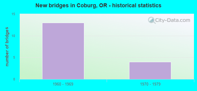
- New bridges - historical statistics
- 131960-1969
- 41970-1979
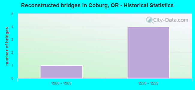
- Reconstructed bridges - Historical Statistics
- 11980-1989
- 41990-1999
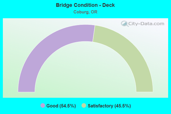
- Bridge Condition - Deck
- 54.5%Good
- 45.5%Satisfactory
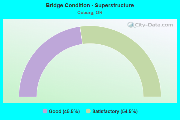
- Bridge Condition - Superstructure
- 45.5%Good
- 54.5%Satisfactory
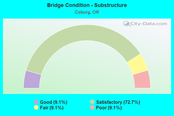
- Bridge Condition - Substructure
- 9.1%Good
- 72.7%Satisfactory
- 9.1%Fair
- 9.1%Poor
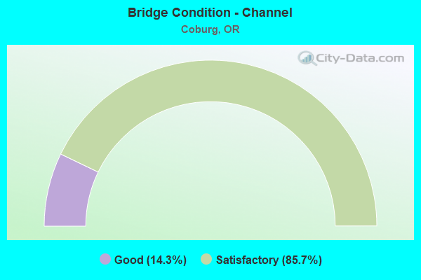
- Bridge Condition - Channel
- 14.3%Good
- 85.7%Satisfactory
Find on map >> Show street view
Structure Number: 8167 001 20344, Location: 001 MI S LANE-LINN LINE (Lat: 44.198672, Lng: -123.060667), Route carried "on" structure: County highway , Year Built: 1960, Year Reconstructed: 1998, Status: Open, Structure Length: 7.28m (23.88ft), Average Daily Traffic: 975 (year 2010), Truck Traffic: 10%, Average Future Daily Traffic: 1,491 (year 2030), Design Load: HS 20, Features Intersected: I-5 (HWY 001), Facility Carried by Structure: COLEMAN ROAD
Minimum Vertical Clearance: 30+ m (98+ ft), Kilometerpoint: 327.405, Lanes on structure: 2, Lanes under structure: 4, Owner: State Highway Agency, Approaching Roadway Width: 7.3m (24.0ft), Material/Design: Prestressed concrete, Design/Construction: Stringer/Multi-beam, Number Of Spans In Main Unit: 4, Length of Maximum Span: 23.3m (76.4ft), Curb-To-Curb Width: 7.3m (24.0ft), Out-to-Out Width: 8.8m (28.9ft)
Condition: Deck: Satisfactory, Superstructure: Satisfactory, Substructure: Satisfactory, Operating Rating: 21.7 metric tons, Method Used To Determine Operating Rating: Load and Resistance Factor Rating (LRFR) rating reported by rating factor(RF) method using HL-93 loadings, Inventory Rating: 16.8 metric tons, Method Used To Determine Inventory Rating: Load and Resistance Factor Rating (LRFR) rating reported by rating factor(RF) method using HL-93 loadings, Structural Evaluation: Meets minimum limits, Deck Geometry: Meets minimum limits, Underclear: High priority of corrective action, Approach Roadway Alignment: Equal to present desirable criteria, Length Of Structure Improvement: 7.30m (23.95ft), Designated Inspection Frequency: Every 24 months, Inspection Date: March 2021, Bridge Improvement Cost: $715,000, Roadway Improvement Cost: $72,000, Total Project Cost: $1,144,000, Deck Structure Type: Concrete Cast-file-Place, Wearing Surface/Protective System: Wearing Surface: Monolithic Concrete
Find on map >> Show street view
Structure Number: 8170 001 20128, Location: 023 MI S LANE-LINN LINE (Lat: 44.167553, Lng: -123.059719), Route carried "on" structure: County highway , Year Built: 1960, Year Reconstructed: 1998, Status: Open, Structure Length: 7.28m (23.88ft), Average Daily Traffic: 975 (year 2010), Truck Traffic: 10%, Average Future Daily Traffic: 1,030 (year 2030), Design Load: HS 20, Features Intersected: I-5 (HWY 001), Facility Carried by Structure: WILKINS ROAD
Minimum Vertical Clearance: 30+ m (98+ ft), Kilometerpoint: 323.929, Lanes on structure: 2, Lanes under structure: 4, Owner: State Highway Agency, Approaching Roadway Width: 7.3m (24.0ft), Skew: 1 degrees, Material/Design: Prestressed concrete, Design/Construction: Stringer/Multi-beam, Number Of Spans In Main Unit: 4, Length of Maximum Span: 23.3m (76.4ft), Curb-To-Curb Width: 7.3m (24.0ft), Out-to-Out Width: 8.8m (28.9ft)
Condition: Deck: Good, Superstructure: Good, Substructure: Satisfactory, Operating Rating: 34.3 metric tons, Method Used To Determine Operating Rating: Load and Resistance Factor Rating (LRFR) rating reported by rating factor(RF) method using HL-93 loadings, Inventory Rating: 26.2 metric tons, Method Used To Determine Inventory Rating: Load and Resistance Factor Rating (LRFR) rating reported by rating factor(RF) method using HL-93 loadings, Structural Evaluation: Equal to present minimum criteria, Deck Geometry: Meets minimum limits, Underclear: Meets minimum limits, Approach Roadway Alignment: Equal to present desirable criteria, Designated Inspection Frequency: Every 24 months, Inspection Date: March 2021, Deck Structure Type: Concrete Cast-file-Place, Wearing Surface/Protective System: Wearing Surface: Monolithic Concrete
Find on map >> Show street view
Structure Number: 8171N001 2005, Location: 031 MI S LANE-LINN LINE (Lat: 44.156311, Lng: -123.056625), Route carried "on" structure: Interstate 5, Year Built: 1960, Status: Open, Structure Length: 3.84m (12.60ft), Average Daily Traffic: 18,109 (year 2020), Truck Traffic: 26%, Average Future Daily Traffic: 23,150 (year 2040), Design Load: HS 20, Features Intersected: MUDDY CREEK
Minimum Vertical Clearance: 30+ m (98+ ft), Kilometerpoint: 322.673, Lanes on structure: 2, Base Highway Network: Yes, Owner: State Highway Agency, Approaching Roadway Width: 12.2m (40.0ft), Skew: 4 degrees, Material/Design: Concrete continuous, Design/Construction: Tee Beam, Number Of Spans In Main Unit: 3, Length of Maximum Span: 12.8m (42.0ft), Curb-To-Curb Width: 12.2m (40.0ft), Out-to-Out Width: 12.9m (42.3ft)
Condition: Deck: Satisfactory, Superstructure: Satisfactory, Substructure: Satisfactory, Channel: Good, Operating Rating: 37.2 metric tons, Method Used To Determine Operating Rating: Load Factor (LF), Inventory Rating: 22.7 metric tons, Method Used To Determine Inventory Rating: Load Factor (LF), Structural Evaluation: Somewhat better than minimum adequacy, Deck Geometry: Better than present minimum criteria, Waterway Adequacy: Equal to present desirable criteria, Approach Roadway Alignment: Equal to present desirable criteria, Designated Inspection Frequency: Every 24 months, Underwater Inspection Frequency: Every 60 months, Inspection Date: March 2021, Underwater Inspection Date: November 2020, Deck Structure Type: Concrete Cast-file-Place, Wearing Surface/Protective System: Wearing Surface: Bituminous, Membrane: Preformed Fabric
Find on map >> Show street view
Structure Number: 8171S001 2005, Location: 031 MI S LANE-LINN LINE (Lat: 44.156497, Lng: -123.057061), Route carried "on" structure: Interstate 5, Year Built: 1960, Status: Open, Structure Length: 3.84m (12.60ft), Average Daily Traffic: 18,109 (year 2020), Truck Traffic: 26%, Average Future Daily Traffic: 23,150 (year 2040), Design Load: HS 20, Features Intersected: MUDDY CREEK
Minimum Vertical Clearance: 30+ m (98+ ft), Kilometerpoint: 322.673, Lanes on structure: 2, Base Highway Network: Yes, Owner: State Highway Agency, Approaching Roadway Width: 12.2m (40.0ft), Skew: 4 degrees, Material/Design: Concrete continuous, Design/Construction: Tee Beam, Number Of Spans In Main Unit: 3, Length of Maximum Span: 12.8m (42.0ft), Curb-To-Curb Width: 12.2m (40.0ft), Out-to-Out Width: 12.9m (42.3ft)
Condition: Deck: Good, Superstructure: Satisfactory, Substructure: Satisfactory, Channel: Satisfactory, Operating Rating: 37.2 metric tons, Method Used To Determine Operating Rating: Load Factor (LF), Inventory Rating: 22.7 metric tons, Method Used To Determine Inventory Rating: Load Factor (LF), Structural Evaluation: Somewhat better than minimum adequacy, Deck Geometry: Better than present minimum criteria, Waterway Adequacy: Equal to present desirable criteria, Approach Roadway Alignment: Equal to present desirable criteria, Designated Inspection Frequency: Every 24 months, Underwater Inspection Frequency: Every 60 months, Inspection Date: March 2021, Underwater Inspection Date: November 2020, Deck Structure Type: Concrete Cast-file-Place, Wearing Surface/Protective System: Wearing Surface: Bituminous, Membrane: Preformed Fabric
Find on map >> Show street view
Structure Number: 8172 001 19915, Location: 061 MI N OF EUGENE NCL (Lat: 44.137086, Lng: -123.051922), Route carried "on" structure: Ramp State highway 5, Year Built: 1960, Year Reconstructed: 1998, Status: Open, Structure Length: 7.28m (23.88ft), Average Daily Traffic: 1,884 (year 2020), Truck Traffic: 26%, Average Future Daily Traffic: 16,058 (year 2030), Design Load: HS 20, Features Intersected: I-5 (HWY 001), Facility Carried by Structure: VAN DUYN ROAD
Minimum Vertical Clearance: 30+ m (98+ ft), Kilometerpoint: 320.501, Lanes on structure: 2, Lanes under structure: 4, Owner: State Highway Agency, Approaching Roadway Width: 9.1m (29.9ft), Skew: 1 degrees, Material/Design: Prestressed concrete, Design/Construction: Stringer/Multi-beam, Number Of Spans In Main Unit: 4, Length of Maximum Span: 23.3m (76.4ft), Curb-To-Curb Width: 9.1m (29.9ft), Out-to-Out Width: 10.6m (34.8ft)
Condition: Deck: Satisfactory, Superstructure: Satisfactory, Substructure: Satisfactory, Operating Rating: 37.3 metric tons, Method Used To Determine Operating Rating: Load and Resistance Factor Rating (LRFR) rating reported by rating factor(RF) method using HL-93 loadings, Inventory Rating: 28.8 metric tons, Method Used To Determine Inventory Rating: Load and Resistance Factor Rating (LRFR) rating reported by rating factor(RF) method using HL-93 loadings, Structural Evaluation: Equal to present minimum criteria, Deck Geometry: Meets minimum limits, Underclear: Meets minimum limits, Approach Roadway Alignment: Equal to present desirable criteria, Designated Inspection Frequency: Every 24 months, Inspection Date: March 2021, Deck Structure Type: Concrete Cast-file-Place, Wearing Surface/Protective System: Wearing Surface: Epoxy Overlay
Find on map >> Show street view
Structure Number: 8173B001 19839, Location: 054 MI N OF EUGENE NCL (Lat: 44.126308, Lng: -123.049158), Route carried "on" structure: County highway , Year Built: 1960, Year Reconstructed: 1987, Status: Open, Structure Length: 7.28m (23.88ft), Average Daily Traffic: 72 (year 2010), Truck Traffic: 1%, Average Future Daily Traffic: 110 (year 2030), Design Load: HS 20, Features Intersected: I-5 (HWY 001), Facility Carried by Structure: REED SERVICE RD
Minimum Vertical Clearance: 30+ m (98+ ft), Kilometerpoint: 319.278, Lanes on structure: 2, Lanes under structure: 4, Owner: State Highway Agency, Approaching Roadway Width: 6.3m (20.7ft), Material/Design: Prestressed concrete, Design/Construction: Stringer/Multi-beam, Number Of Spans In Main Unit: 4, Length of Maximum Span: 23.3m (76.4ft), Curb-To-Curb Width: 6.3m (20.7ft), Out-to-Out Width: 7.6m (24.9ft)
Condition: Deck: Satisfactory, Superstructure: Satisfactory, Substructure: Satisfactory, Operating Rating: 24.0 metric tons, Method Used To Determine Operating Rating: Load and Resistance Factor Rating (LRFR) rating reported by rating factor(RF) method using HL-93 loadings, Inventory Rating: 18.5 metric tons, Method Used To Determine Inventory Rating: Load and Resistance Factor Rating (LRFR) rating reported by rating factor(RF) method using HL-93 loadings, Structural Evaluation: Somewhat better than minimum adequacy, Deck Geometry: Somewhat better than minimum adequacy, Underclear: High priority of corrective action, Approach Roadway Alignment: Equal to present desirable criteria, Length Of Structure Improvement: 7.30m (23.95ft), Designated Inspection Frequency: Every 24 months, Inspection Date: March 2021, Bridge Improvement Cost: $615,000, Roadway Improvement Cost: $61,000, Total Project Cost: $984,000, Deck Structure Type: Concrete Cast-file-Place, Wearing Surface/Protective System: Wearing Surface: Monolithic Concrete
Find on map >> Show street view
Structure Number: 9174 001F19764, Location: 047 MI N OF EUGENE NCL (Lat: 44.116469, Lng: -123.046600), Route carried "on" structure: Ramp State highway 5, Year Built: 1963, Year Reconstructed: 1996, Status: Open, Structure Length: 7.10m (23.29ft), Average Daily Traffic: 34 (year 2020), Truck Traffic: 23%, Average Future Daily Traffic: 420 (year 2030), Design Load: HS 20, Features Intersected: I-5 (HWY 001), Facility Carried by Structure: EGGE FRONTAGE RD
Minimum Vertical Clearance: 30+ m (98+ ft), Kilometerpoint: 318.071, Lanes on structure: 2, Lanes under structure: 4, Owner: State Highway Agency, Approaching Roadway Width: 6.1m (20.0ft), Skew: 1 degrees, Material/Design: Prestressed concrete, Design/Construction: Stringer/Multi-beam, Number Of Spans In Main Unit: 2, Number Of Approach Spans: 2, Length of Maximum Span: 23.9m (78.4ft), Curb-To-Curb Width: 6.1m (20.0ft), Out-to-Out Width: 7.6m (24.9ft)
Condition: Deck: Satisfactory, Superstructure: Satisfactory, Substructure: Satisfactory, Operating Rating: 18.8 metric tons, Method Used To Determine Operating Rating: Load and Resistance Factor Rating (LRFR) rating reported by rating factor(RF) method using HL-93 loadings, Inventory Rating: 14.6 metric tons, Method Used To Determine Inventory Rating: Load and Resistance Factor Rating (LRFR) rating reported by rating factor(RF) method using HL-93 loadings, Structural Evaluation: Meets minimum limits, Deck Geometry: High priority of replacement, Underclear: Meets minimum limits, Approach Roadway Alignment: Equal to present desirable criteria, Length Of Structure Improvement: 7.10m (23.29ft), Designated Inspection Frequency: Every 24 months, Inspection Date: March 2021, Bridge Improvement Cost: $599,000, Roadway Improvement Cost: $60,000, Total Project Cost: $959,000, Deck Structure Type: Concrete Cast-file-Place
Find on map >> Show street view
Structure Number: M407 001 20205, Location: 015 M S LANE-LINN CO LINE (Lat: 44.178611, Lng: -123.060764), Route carried "on" structure: Interstate 5, Year Built: 1960, Status: Open, Structure Length: 0.61m (2.00ft), Average Daily Traffic: 36,219 (year 2020), Truck Traffic: 26%, Average Future Daily Traffic: 46,300 (year 2040), Design Load: HS 20, Features Intersected: CREEK
Minimum Vertical Clearance: 30+ m (98+ ft), Kilometerpoint: 325.007, Lanes on structure: 4, Base Highway Network: Yes, Owner: State Highway Agency, Approaching Roadway Width: 24.4m (80.1ft), Material/Design: Concrete continuous, Design/Construction: Culvert, Number Of Spans In Main Unit: 2, Length of Maximum Span: 3.0m (9.8ft)
Condition: Channel: Satisfactory, Culverts: Satisfactory, Operating Rating: 33.0 metric tons, Method Used To Determine Operating Rating: Load and Resistance Factor Rating (LRFR) rating reported by rating factor(RF) method using HL-93 loadings, Inventory Rating: 25.6 metric tons, Method Used To Determine Inventory Rating: Load and Resistance Factor Rating (LRFR) rating reported by rating factor(RF) method using HL-93 loadings, Structural Evaluation: Equal to present minimum criteria, Waterway Adequacy: Equal to present desirable criteria, Approach Roadway Alignment: Equal to present desirable criteria, Designated Inspection Frequency: Every 24 months, Inspection Date: March 2021
Find on map >> Show street view
Structure Number: 12492 052600044, Location: 050 MI SE HARRISBURG (Lat: 44.212761, Lng: -123.075869), Route carried "on" structure: County highway C0526, Year Built: 1971, Status: Open, Structure Length: 1.10m (3.61ft), Average Daily Traffic: 319 (year 2021), Truck Traffic: 1%, Average Future Daily Traffic: 438 (year 2041), Design Load: HS 20, Features Intersected: MUDDY CREEK, Facility Carried by Structure: BUSH GARDEN DR.
Minimum Vertical Clearance: 30+ m (98+ ft), Kilometerpoint: 0.708, Lanes on structure: 2, Owner: County Highway Agency, Approaching Roadway Width: 8.2m (26.9ft), Skew: 4 degrees, Material/Design: Prestressed concrete, Design/Construction: Slab, Number Of Spans In Main Unit: 1, Length of Maximum Span: 10.7m (35.1ft), Curb or Sidewalk Widths: Left: 0.2m (0.7ft), Right: 0.2m (0.7ft), Curb-To-Curb Width: 7.9m (25.9ft), Out-to-Out Width: 8.5m (27.9ft)
Condition: Deck: Good, Superstructure: Good, Substructure: Poor, Channel: Satisfactory, Operating Rating: 57.2 metric tons, Method Used To Determine Operating Rating: Load Factor (LF), Inventory Rating: 34.5 metric tons, Method Used To Determine Inventory Rating: Load Factor (LF), Structural Evaluation: Meets minimum limits, Deck Geometry: Somewhat better than minimum adequacy, Waterway Adequacy: Better than present minimum criteria, Approach Roadway Alignment: Equal to present desirable criteria, Length Of Structure Improvement: 1.40m (4.59ft), Designated Inspection Frequency: Every 24 months, Inspection Date: May 2021, Bridge Improvement Cost: $150,000, Roadway Improvement Cost: $15,000, Total Project Cost: $240,000, Deck Structure Type: Other, Wearing Surface/Protective System: Wearing Surface: Bituminous
Find on map >> Show street view
Structure Number: 14258A161000356, Location: 040 MI N OF COBURG (Lat: 44.193239, Lng: -123.071461), Route carried "on" structure: County highway A0466, Year Built: 1978, Status: Open, Structure Length: 1.40m (4.59ft), Average Daily Traffic: 2,771 (year 2020), Truck Traffic: 10%, Average Future Daily Traffic: 3,246 (year 2025), Design Load: HS 20, Features Intersected: MUDDY CREEK, Facility Carried by Structure: COBURG RD NORTH
Minimum Vertical Clearance: 30+ m (98+ ft), Kilometerpoint: 5.818, Lanes on structure: 2, Owner: County Highway Agency, Approaching Roadway Width: 8.5m (27.9ft), Skew: 1 degrees, Material/Design: Prestressed concrete, Design/Construction: Slab, Number Of Spans In Main Unit: 1, Length of Maximum Span: 13.7m (44.9ft), Curb-To-Curb Width: 9.1m (29.9ft), Out-to-Out Width: 9.8m (32.2ft)
Condition: Deck: Good, Superstructure: Good, Substructure: Good, Channel: Satisfactory, Operating Rating: 59.0 metric tons, Method Used To Determine Operating Rating: Allowable Stress (AS), Inventory Rating: 35.4 metric tons, Method Used To Determine Inventory Rating: Allowable Stress (AS), Structural Evaluation: Better than present minimum criteria, Deck Geometry: Meets minimum limits, Waterway Adequacy: Better than present minimum criteria, Approach Roadway Alignment: Equal to present desirable criteria, Designated Inspection Frequency: Every 24 months, Inspection Date: July 2020, Deck Structure Type: Other, Wearing Surface/Protective System: Wearing Surface: Bituminous
Find on map >> Show street view
Structure Number: 39C14316200004, Location: 020 MI N OF COBURG (Lat: 44.167531, Lng: -123.063761), Route carried "on" structure: County highway C1620, Year Built: 1973, Status: Open, Structure Length: 1.10m (3.61ft), Average Daily Traffic: 240 (year 2020), Truck Traffic: 5%, Average Future Daily Traffic: 280 (year 2025), Design Load: HS 20, Features Intersected: MUDDY CREEK, Facility Carried by Structure: WILKINS RD
Minimum Vertical Clearance: 30+ m (98+ ft), Kilometerpoint: 0.649, Lanes on structure: 2, Owner: County Highway Agency, Approaching Roadway Width: 5.8m (19.0ft), Material/Design: Prestressed concrete, Design/Construction: Slab, Number Of Spans In Main Unit: 1, Length of Maximum Span: 10.4m (34.1ft), Curb-To-Curb Width: 7.1m (23.3ft), Out-to-Out Width: 7.3m (24.0ft)
Condition: Deck: Good, Superstructure: Good, Substructure: Fair, Channel: Satisfactory, Operating Rating: 46.0 metric tons, Method Used To Determine Operating Rating: Load and Resistance Factor Rating (LRFR) rating reported by rating factor(RF) method using HL-93 loadings, Inventory Rating: 27.9 metric tons, Method Used To Determine Inventory Rating: Load and Resistance Factor Rating (LRFR) rating reported by rating factor(RF) method using HL-93 loadings, Structural Evaluation: Somewhat better than minimum adequacy, Deck Geometry: Meets minimum limits, Waterway Adequacy: Better than present minimum criteria, Approach Roadway Alignment: Equal to present desirable criteria, Designated Inspection Frequency: Every 24 months, Inspection Date: July 2020, Deck Structure Type: Other, Wearing Surface/Protective System: Wearing Surface: Bituminous
Find on map >> Show street view
Structure Number: 39C145163300034, Location: 010 MI S OF COBURG (Lat: 44.128611, Lng: -123.072481), Route carried "on" structure: County highway C1663, Year Built: 1978, Status: Open, Structure Length: 0.73m (2.40ft), Average Daily Traffic: 217 (year 2020), Truck Traffic: 10%, Average Future Daily Traffic: 252 (year 2025), Design Load: HS 20, Features Intersected: OVERFLOW, Facility Carried by Structure: FUNKE ROAD
Minimum Vertical Clearance: 30+ m (98+ ft), Kilometerpoint: 0.555, Lanes on structure: 2, Owner: County Highway Agency, Approaching Roadway Width: 7.3m (24.0ft), Material/Design: Prestressed concrete, Design/Construction: Slab, Number Of Spans In Main Unit: 1, Length of Maximum Span: 7.0m (23.0ft), Curb-To-Curb Width: 8.4m (27.6ft), Out-to-Out Width: 8.5m (27.9ft)
Condition: Deck: Good, Superstructure: Good, Substructure: Satisfactory, Channel: Satisfactory, Operating Rating: 78.0 metric tons, Method Used To Determine Operating Rating: Load Factor (LF), Inventory Rating: 35.4 metric tons, Method Used To Determine Inventory Rating: Load Factor (LF), Structural Evaluation: Equal to present minimum criteria, Deck Geometry: Somewhat better than minimum adequacy, Waterway Adequacy: Equal to present desirable criteria, Approach Roadway Alignment: Equal to present desirable criteria, Designated Inspection Frequency: Every 24 months, Inspection Date: July 2020, Deck Structure Type: Other, Wearing Surface/Protective System: Wearing Surface: Bituminous
Find on map >> Show street view
Structure Number: 8167 001 20344, Location: 001 MI S LANE-LINN LINE (Lat: 44.198672, Lng: -123.060667), Route carried "under" structure: Interstate 5, Year Built: 1960, Structure Length: 0. m, Average Daily Traffic: 36,219 (year 2020), Truck Traffic: 26%, Features Intersected: I-5 (HWY 001), Facility Carried by Structure: COLEMAN ROAD
Minimum Vertical Clearance: 5.13m (16.83ft), Kilometerpoint: 327.405, Lanes on structure: 2, Lanes under structure: 4, Material/Design: Prestressed concrete, Design/Construction: Stringer/Multi-beam, Length of Maximum Span: 23.3m (76.4ft)
Find on map >> Show street view
Structure Number: 8170 001 20128, Location: 023 MI S LANE-LINN LINE (Lat: 44.167553, Lng: -123.059719), Route carried "under" structure: Interstate 5, Year Built: 1960, Structure Length: 0. m, Average Daily Traffic: 36,219 (year 2020), Truck Traffic: 26%, Features Intersected: I-5 (HWY 001), Facility Carried by Structure: WILKINS ROAD
Minimum Vertical Clearance: 5.21m (17.09ft), Kilometerpoint: 323.929, Lanes on structure: 2, Lanes under structure: 4, Material/Design: Prestressed concrete, Design/Construction: Stringer/Multi-beam, Length of Maximum Span: 23.3m (76.4ft)
Find on map >> Show street view
Structure Number: 8172 001 19915, Location: 061 MI N OF EUGENE NCL (Lat: 44.137086, Lng: -123.051922), Route carried "under" structure: Interstate 5, Year Built: 1960, Structure Length: 0. m, Average Daily Traffic: 36,219 (year 2020), Truck Traffic: 26%, Features Intersected: I-5 (HWY 001), Facility Carried by Structure: VAN DUYN ROAD
Minimum Vertical Clearance: 4.93m (16.17ft), Kilometerpoint: 320.501, Lanes on structure: 2, Lanes under structure: 4, Material/Design: Prestressed concrete, Design/Construction: Stringer/Multi-beam, Length of Maximum Span: 23.3m (76.4ft)
Find on map >> Show street view
Structure Number: 8173B001 19839, Location: 054 MI N OF EUGENE NCL (Lat: 44.126308, Lng: -123.049158), Route carried "under" structure: Interstate 5, Year Built: 1960, Structure Length: 0. m, Average Daily Traffic: 36,219 (year 2020), Truck Traffic: 26%, Features Intersected: I-5 (HWY 001), Facility Carried by Structure: REED SERVICE RD
Minimum Vertical Clearance: 5.61m (18.41ft), Kilometerpoint: 319.278, Lanes on structure: 2, Lanes under structure: 4, Material/Design: Prestressed concrete, Design/Construction: Stringer/Multi-beam, Length of Maximum Span: 23.3m (76.4ft)
Find on map >> Show street view
Structure Number: 9174 001F19764, Location: 047 MI N OF EUGENE NCL (Lat: 44.116469, Lng: -123.046600), Route carried "under" structure: Interstate 5, Year Built: 1963, Structure Length: 0. m, Average Daily Traffic: 36,219 (year 2020), Truck Traffic: 26%, Features Intersected: I-5 (HWY 001), Facility Carried by Structure: EGGE FRONTAGE RD
Minimum Vertical Clearance: 5.33m (17.49ft), Kilometerpoint: 318.071, Lanes on structure: 2, Lanes under structure: 4, Material/Design: Prestressed concrete, Design/Construction: Stringer/Multi-beam, Length of Maximum Span: 23.9m (78.4ft)