Bridge Statistics for Condon, Montana (MT)
Condition, Traffic, Stress, Structural Evaluation, Project Costs
- National Bridge Inventory (NBI) Statistics
- 24Number of bridges
- 157ft / 48.4mTotal length
- $315,000Total costs
- 1,511Total average daily traffic
- 33Total average daily truck traffic
- 1,716Total future (year 2037) average daily traffic
- National Bridge Inventory (NBI) Registered Bridges for Condon
- No street view available for this location
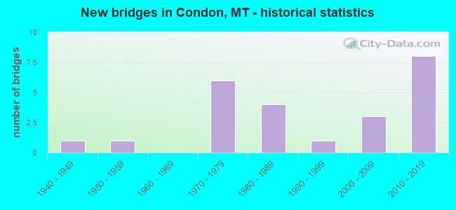
- New bridges - historical statistics
- 11940-1949
- 11950-1959
- 61970-1979
- 41980-1989
- 11990-1999
- 32000-2009
- 82010-2019
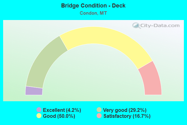
- Bridge Condition - Deck
- 4.2%Excellent
- 29.2%Very good
- 50.0%Good
- 16.7%Satisfactory
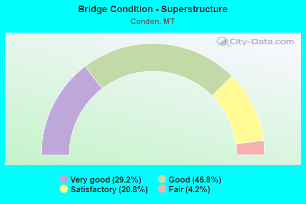
- Bridge Condition - Superstructure
- 29.2%Very good
- 45.8%Good
- 20.8%Satisfactory
- 4.2%Fair
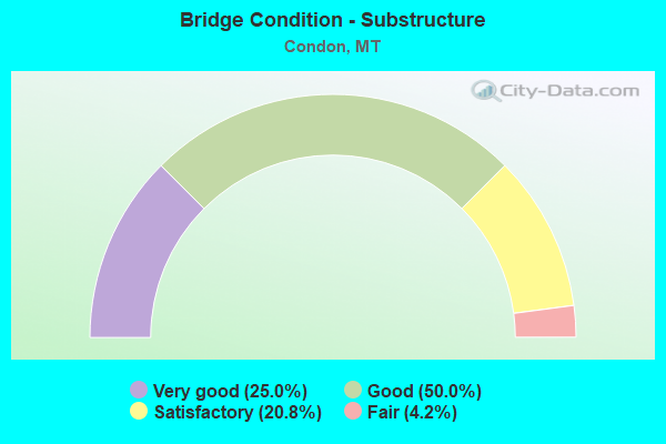
- Bridge Condition - Substructure
- 25.0%Very good
- 50.0%Good
- 20.8%Satisfactory
- 4.2%Fair
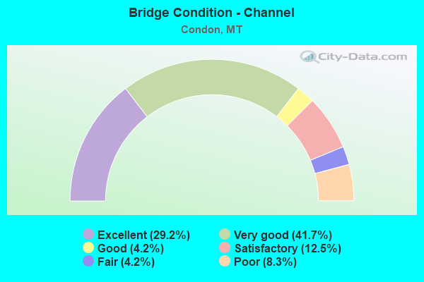
- Bridge Condition - Channel
- 29.2%Excellent
- 41.7%Very good
- 4.2%Good
- 12.5%Satisfactory
- 4.2%Fair
- 8.3%Poor
Find on map >> Show street view
Structure Number: 11001000000113, Location: KRAFT CREEK (Lat: 47.456489, Lng: -113.756550), Route carried "on" structure: Federal lands road 9590, Year Built: 1985, Status: Open, Structure Length: 1.72m (5.64ft), Average Daily Traffic: 1 (year 1992), Average Future Daily Traffic: 1 (year 2042), Design Load: HS 20, Features Intersected: KRAFT CREEK, Facility Carried by Structure: FOREST ROAD
Minimum Vertical Clearance: 30+ m (98+ ft), Kilometerpoint: 0.276, Lanes on structure: 1, Owner: U.S. Forest Service, Approaching Roadway Width: 4.9m (16.1ft), Skew: 3 degrees, Material/Design: Prestressed concrete, Design/Construction: Stringer/Multi-beam, Number Of Spans In Main Unit: 1, Length of Maximum Span: 16.8m (55.1ft), Curb or Sidewalk Widths: Left: 0.2m (0.7ft), Right: 0.2m (0.7ft), Curb-To-Curb Width: 4.3m (14.1ft), Out-to-Out Width: 4.6m (15.1ft)
Condition: Deck: Good, Superstructure: Good, Substructure: Good, Channel: Very good, Operating Rating: 43.4 metric tons, Method Used To Determine Operating Rating: Load and Resistance Factor Rating (LRFR) rating reported by rating factor(RF) method using HL-93 loadings, Inventory Rating: 34.0 metric tons, Method Used To Determine Inventory Rating: Load and Resistance Factor Rating (LRFR) rating reported by rating factor(RF) method using HL-93 loadings, Structural Evaluation: Better than present minimum criteria, Deck Geometry: Equal to present minimum criteria, Waterway Adequacy: Superior to present desirable criteria, Approach Roadway Alignment: Equal to present desirable criteria, Designated Inspection Frequency: Every 48 months, Inspection Date: September 2020, Deck Structure Type: Other, Wearing Surface/Protective System: Wearing Surface: Monolithic Concrete
Find on map >> Show street view
Structure Number: 11001000000114, Location: ELK CREEK ROAD (Lat: 47.492161, Lng: -113.741764), Route carried "on" structure: Federal lands road 9591, Year Built: 1981, Status: Open, Structure Length: 2.29m (7.51ft), Average Daily Traffic: 10 (year 1992), Average Future Daily Traffic: 15 (year 2042), Design Load: HS 20, Features Intersected: GLACIER CREEK, Facility Carried by Structure: FOREST ROAD
Minimum Vertical Clearance: 30+ m (98+ ft), Kilometerpoint: 6.435, Lanes on structure: 1, Owner: U.S. Forest Service, Approaching Roadway Width: 4.6m (15.1ft), Material/Design: Prestressed concrete, Design/Construction: Stringer/Multi-beam, Number Of Spans In Main Unit: 1, Length of Maximum Span: 22.6m (74.1ft), Curb-To-Curb Width: 4.5m (14.8ft), Out-to-Out Width: 5.1m (16.7ft)
Condition: Deck: Good, Superstructure: Good, Substructure: Good, Channel: Satisfactory, Operating Rating: 71.6 metric tons, Method Used To Determine Operating Rating: Load and Resistance Factor Rating (LRFR) rating reported by rating factor(RF) method using HL-93 loadings, Inventory Rating: 55.4 metric tons, Method Used To Determine Inventory Rating: Load and Resistance Factor Rating (LRFR) rating reported by rating factor(RF) method using HL-93 loadings, Structural Evaluation: Better than present minimum criteria, Deck Geometry: Equal to present minimum criteria, Waterway Adequacy: Superior to present desirable criteria, Approach Roadway Alignment: Equal to present desirable criteria, Designated Inspection Frequency: Every 24 months, Inspection Date: August 2021, Deck Structure Type: Concrete Cast-file-Place, Wearing Surface/Protective System: Wearing Surface: Integral Concrete
Find on map >> Show street view
Structure Number: 11001000000115, Location: ELK CREEK ROAD (Lat: 47.493122, Lng: -113.769728), Route carried "on" structure: Federal lands road 9591, Year Built: 1981, Status: Open, Structure Length: 1.99m (6.53ft), Average Daily Traffic: 10 (year 1992), Average Future Daily Traffic: 15 (year 2042), Design Load: HS 20, Features Intersected: ELK CREEK, Facility Carried by Structure: FOREST ROAD
Minimum Vertical Clearance: 30+ m (98+ ft), Kilometerpoint: 8.990, Lanes on structure: 1, Owner: U.S. Forest Service, Approaching Roadway Width: 5.5m (18.0ft), Material/Design: Prestressed concrete, Design/Construction: Stringer/Multi-beam, Number Of Spans In Main Unit: 1, Length of Maximum Span: 19.5m (64.0ft), Curb-To-Curb Width: 4.3m (14.1ft), Out-to-Out Width: 5.1m (16.7ft)
Condition: Deck: Good, Superstructure: Good, Substructure: Good, Channel: Very good, Operating Rating: 79.4 metric tons, Method Used To Determine Operating Rating: Load and Resistance Factor Rating (LRFR) rating reported by rating factor(RF) method using HL-93 loadings, Inventory Rating: 61.2 metric tons, Method Used To Determine Inventory Rating: Load and Resistance Factor Rating (LRFR) rating reported by rating factor(RF) method using HL-93 loadings, Structural Evaluation: Better than present minimum criteria, Deck Geometry: Equal to present minimum criteria, Waterway Adequacy: Superior to present desirable criteria, Approach Roadway Alignment: Equal to present desirable criteria, Designated Inspection Frequency: Every 48 months, Inspection Date: August 2021, Deck Structure Type: Concrete Cast-file-Place, Wearing Surface/Protective System: Wearing Surface: Integral Concrete
Find on map >> Show street view
Structure Number: 11001000010924, Location: CONDON AREA (Lat: 47.629989, Lng: -113.715819), Route carried "on" structure: Federal lands road 901, Year Built: 2008, Status: Open, Structure Length: 1.28m (4.20ft), Average Daily Traffic: 40 (year 0000), Average Future Daily Traffic: 60 (year 2042), Design Load: HS 20, Features Intersected: PONY CREEK, Facility Carried by Structure: NFSR
Minimum Vertical Clearance: 30+ m (98+ ft), Kilometerpoint: 13.212, Lanes on structure: 1, Owner: U.S. Forest Service, Approaching Roadway Width: 4.3m (14.1ft), Skew: 1 degrees, Material/Design: Prestressed concrete, Design/Construction: Stringer/Multi-beam, Number Of Spans In Main Unit: 1, Length of Maximum Span: 12.5m (41.0ft), Curb or Sidewalk Widths: Left: 0.3m (1.0ft), Right: 0.3m (1.0ft), Curb-To-Curb Width: 4.3m (14.1ft), Out-to-Out Width: 5.6m (18.4ft)
Condition: Deck: Good, Superstructure: Good, Substructure: Good, Channel: Excellent, Operating Rating: 28.2 metric tons, Method Used To Determine Operating Rating: Load and Resistance Factor Rating (LRFR) rating reported by rating factor(RF) method using HL-93 loadings, Inventory Rating: 21.7 metric tons, Method Used To Determine Inventory Rating: Load and Resistance Factor Rating (LRFR) rating reported by rating factor(RF) method using HL-93 loadings, Structural Evaluation: Equal to present minimum criteria, Deck Geometry: Equal to present minimum criteria, Waterway Adequacy: Superior to present desirable criteria, Approach Roadway Alignment: Equal to present desirable criteria, Designated Inspection Frequency: Every 48 months, Inspection Date: October 2020, Deck Structure Type: Other, Wearing Surface/Protective System: Wearing Surface: Monolithic Concrete, Membrane: Epoxy
Find on map >> Show street view
Structure Number: 11001000010926, Location: CONDON AREA (Lat: 47.619831, Lng: -113.705961), Route carried "on" structure: Federal lands road 901, Year Built: 2008, Status: Open, Structure Length: 1.31m (4.30ft), Average Daily Traffic: 40 (year 2018), Average Future Daily Traffic: 60 (year 2042), Design Load: HS 20, Features Intersected: CAT CREEK, Facility Carried by Structure: NFSR
Minimum Vertical Clearance: 30+ m (98+ ft), Kilometerpoint: 11.814, Lanes on structure: 1, Owner: U.S. Forest Service, Approaching Roadway Width: 4.3m (14.1ft), Material/Design: Prestressed concrete, Design/Construction: Stringer/Multi-beam, Number Of Spans In Main Unit: 1, Length of Maximum Span: 12.5m (41.0ft), Curb or Sidewalk Widths: Left: 0.3m (1.0ft), Right: 0.3m (1.0ft), Curb-To-Curb Width: 4.3m (14.1ft), Out-to-Out Width: 5.3m (17.4ft)
Condition: Deck: Good, Superstructure: Good, Substructure: Good, Channel: Very good, Operating Rating: 29.5 metric tons, Method Used To Determine Operating Rating: Load and Resistance Factor Rating (LRFR) rating reported by rating factor(RF) method using HL-93 loadings, Inventory Rating: 22.7 metric tons, Method Used To Determine Inventory Rating: Load and Resistance Factor Rating (LRFR) rating reported by rating factor(RF) method using HL-93 loadings, Structural Evaluation: Equal to present minimum criteria, Deck Geometry: Equal to present minimum criteria, Waterway Adequacy: Superior to present desirable criteria, Approach Roadway Alignment: Equal to present desirable criteria, Designated Inspection Frequency: Every 48 months, Inspection Date: October 2020, Deck Structure Type: Other, Wearing Surface/Protective System: Wearing Surface: Monolithic Concrete, Membrane: Epoxy
Find on map >> Show street view
Structure Number: 11001000012242, Location: CONDON (Lat: 47.552931, Lng: -113.667500), Route carried "on" structure: Federal lands road 9762, Year Built: 2010, Status: Open, Structure Length: 1.68m (5.51ft), Average Daily Traffic: 40 (year 0000), Average Future Daily Traffic: 60 (year 2042), Design Load: H 20, Features Intersected: SMITH CREEK, Facility Carried by Structure: NFSR
Minimum Vertical Clearance: 30+ m (98+ ft), Kilometerpoint: 2.636, Lanes on structure: 1, Owner: U.S. Forest Service, Approaching Roadway Width: 5.3m (17.4ft), Material/Design: Prestressed concrete, Design/Construction: Stringer/Multi-beam, Number Of Spans In Main Unit: 1, Length of Maximum Span: 15.8m (51.8ft), Curb or Sidewalk Widths: Left: 0.3m (1.0ft), Right: 0.3m (1.0ft), Curb-To-Curb Width: 5.3m (17.4ft), Out-to-Out Width: 5.9m (19.4ft)
Condition: Deck: Very good, Superstructure: Very good, Substructure: Good, Channel: Excellent, Operating Rating: 37.9 metric tons, Method Used To Determine Operating Rating: Load and Resistance Factor Rating (LRFR) rating reported by rating factor(RF) method using HL-93 loadings, Inventory Rating: 29.5 metric tons, Method Used To Determine Inventory Rating: Load and Resistance Factor Rating (LRFR) rating reported by rating factor(RF) method using HL-93 loadings, Structural Evaluation: Better than present minimum criteria, Deck Geometry: High priority of corrective action, Waterway Adequacy: Superior to present desirable criteria, Approach Roadway Alignment: Equal to present desirable criteria, Designated Inspection Frequency: Every 48 months, Inspection Date: August 2021, Deck Structure Type: Other
Find on map >> Show street view
Structure Number: 11001000012245, Location: CONCON (Lat: 47.579119, Lng: -113.687131), Route carried "on" structure: Federal lands road 901, Year Built: 2010, Status: Open, Structure Length: 1.41m (4.63ft), Average Daily Traffic: 50 (year 0000), Average Future Daily Traffic: 75 (year 2042), Design Load: HL 93, Features Intersected: CONDON CREEK, Facility Carried by Structure: NFSR
Minimum Vertical Clearance: 30+ m (98+ ft), Kilometerpoint: 6.212, Lanes on structure: 1, Owner: U.S. Forest Service, Approaching Roadway Width: 4.9m (16.1ft), Skew: 2 degrees, Material/Design: Prestressed concrete, Design/Construction: Tee Beam, Number Of Spans In Main Unit: 1, Length of Maximum Span: 13.4m (44.0ft), Curb or Sidewalk Widths: Left: 0.3m (1.0ft), Right: 0.3m (1.0ft), Curb-To-Curb Width: 4.9m (16.1ft), Out-to-Out Width: 5.6m (18.4ft)
Condition: Deck: Very good, Superstructure: Very good, Substructure: Very good, Channel: Good, Operating Rating: 31.8 metric tons, Method Used To Determine Operating Rating: Load and Resistance Factor Rating (LRFR) rating reported by rating factor(RF) method using HL-93 loadings, Inventory Rating: 24.6 metric tons, Method Used To Determine Inventory Rating: Load and Resistance Factor Rating (LRFR) rating reported by rating factor(RF) method using HL-93 loadings, Structural Evaluation: Equal to present minimum criteria, Deck Geometry: High priority of corrective action, Waterway Adequacy: Superior to present desirable criteria, Approach Roadway Alignment: Equal to present desirable criteria, Designated Inspection Frequency: Every 24 months, Inspection Date: August 2021, Deck Structure Type: Concrete Precast Panels, Wearing Surface/Protective System: Wearing Surface: Monolithic Concrete
Find on map >> Show street view
Structure Number: 11001000013483, Location: CONDON LOOP ROAD (Lat: 47.586369, Lng: -113.737619), Route carried "on" structure: Federal lands road 124, Year Built: 2010, Status: Open, Structure Length: 1.58m (5.18ft), Average Daily Traffic: 40 (year 2018), Average Future Daily Traffic: 60 (year 2042), Design Load: HL 93, Features Intersected: CONDON CREEK, Facility Carried by Structure: FOREST ROAD
Minimum Vertical Clearance: 30+ m (98+ ft), Kilometerpoint: 1.270, Lanes on structure: 1, Owner: U.S. Forest Service, Approaching Roadway Width: 5.2m (17.1ft), Skew: 2 degrees, Material/Design: Prestressed concrete, Design/Construction: Tee Beam, Number Of Spans In Main Unit: 1, Length of Maximum Span: 14.0m (45.9ft), Curb or Sidewalk Widths: Left: 0.3m (1.0ft), Right: 0.3m (1.0ft), Curb-To-Curb Width: 4.6m (15.1ft), Out-to-Out Width: 5.2m (17.1ft)
Condition: Deck: Very good, Superstructure: Very good, Substructure: Very good, Channel: Excellent, Operating Rating: 40.5 metric tons, Method Used To Determine Operating Rating: Load and Resistance Factor Rating (LRFR) rating reported by rating factor(RF) method using HL-93 loadings, Inventory Rating: 31.8 metric tons, Method Used To Determine Inventory Rating: Load and Resistance Factor Rating (LRFR) rating reported by rating factor(RF) method using HL-93 loadings, Structural Evaluation: Better than present minimum criteria, Deck Geometry: Better than present minimum criteria, Waterway Adequacy: Superior to present desirable criteria, Approach Roadway Alignment: Equal to present desirable criteria, Designated Inspection Frequency: Every 48 months, Inspection Date: August 2021, Deck Structure Type: Concrete Precast Panels, Wearing Surface/Protective System: Wearing Surface: Monolithic Concrete
Find on map >> Show street view
Structure Number: 11001000015573, Location: NO DATA ENTERED (Lat: 47.611831, Lng: -113.698200), Route carried "on" structure: Federal lands road 901, Year Built: 2013, Status: Open, Structure Length: 1.77m (5.81ft), Average Daily Traffic: 40 (year 2018), Average Future Daily Traffic: 60 (year 2042), Design Load: HL 93, Features Intersected: DOG CREEK, Facility Carried by Structure: FOREST ROAD
Minimum Vertical Clearance: 30+ m (98+ ft), Kilometerpoint: 10.620, Lanes on structure: 1, Owner: U.S. Forest Service, Approaching Roadway Width: 4.3m (14.1ft), Material/Design: Prestressed concrete, Design/Construction: Stringer/Multi-beam, Number Of Spans In Main Unit: 1, Length of Maximum Span: 17.1m (56.1ft), Curb or Sidewalk Widths: Left: 0.3m (1.0ft), Right: 0.3m (1.0ft), Curb-To-Curb Width: 4.9m (16.1ft), Out-to-Out Width: 5.5m (18.0ft)
Condition: Deck: Very good, Superstructure: Very good, Substructure: Very good, Channel: Excellent, Operating Rating: 36.3 metric tons, Method Used To Determine Operating Rating: Load and Resistance Factor Rating (LRFR) rating reported by rating factor(RF) method using HL-93 loadings, Inventory Rating: 28.2 metric tons, Method Used To Determine Inventory Rating: Load and Resistance Factor Rating (LRFR) rating reported by rating factor(RF) method using HL-93 loadings, Structural Evaluation: Better than present minimum criteria, Deck Geometry: High priority of corrective action, Waterway Adequacy: Superior to present desirable criteria, Approach Roadway Alignment: Equal to present desirable criteria, Designated Inspection Frequency: Every 48 months, Inspection Date: August 2021, Deck Structure Type: Concrete Precast Panels, Wearing Surface/Protective System: Wearing Surface: Bituminous
Find on map >> Show street view
Structure Number: 11001000015574, Location: NORTH FORK COLD CREEK (Lat: 47.563869, Lng: -113.814219), Route carried "on" structure: Federal lands road 9568, Year Built: 2012, Status: Open, Structure Length: 1.86m (6.10ft), Average Daily Traffic: 40 (year 0000), Average Future Daily Traffic: 60 (year 2042), Design Load: HL 93, Features Intersected: NORTH FORK COLD CREEK, Facility Carried by Structure: FOREST ROAD
Minimum Vertical Clearance: 30+ m (98+ ft), Kilometerpoint: 2.184, Lanes on structure: 1, Owner: U.S. Forest Service, Approaching Roadway Width: 4.3m (14.1ft), Skew: 2 degrees, Material/Design: Prestressed concrete, Design/Construction: Stringer/Multi-beam, Number Of Spans In Main Unit: 1, Length of Maximum Span: 18.0m (59.1ft), Curb or Sidewalk Widths: Left: 0.3m (1.0ft), Right: 0.3m (1.0ft), Curb-To-Curb Width: 4.3m (14.1ft), Out-to-Out Width: 4.9m (16.1ft)
Condition: Deck: Very good, Superstructure: Very good, Substructure: Very good, Channel: Very good, Operating Rating: 39.9 metric tons, Method Used To Determine Operating Rating: Load and Resistance Factor Rating (LRFR) rating reported by rating factor(RF) method using HL-93 loadings, Inventory Rating: 31.1 metric tons, Method Used To Determine Inventory Rating: Load and Resistance Factor Rating (LRFR) rating reported by rating factor(RF) method using HL-93 loadings, Structural Evaluation: Better than present minimum criteria, Deck Geometry: Equal to present minimum criteria, Waterway Adequacy: Superior to present desirable criteria, Approach Roadway Alignment: Equal to present desirable criteria, Designated Inspection Frequency: Every 48 months, Inspection Date: September 2020, Deck Structure Type: Concrete Precast Panels, Wearing Surface/Protective System: Wearing Surface: Bituminous
Find on map >> Show street view
Structure Number: 11001000015608, Location: COLD CREEK ROAD (Lat: 47.552700, Lng: -113.795869), Route carried "on" structure: Federal lands road 903, Year Built: 2012, Status: Open, Structure Length: 2.06m (6.76ft), Average Daily Traffic: 40 (year 2018), Average Future Daily Traffic: 60 (year 2042), Design Load: HL 93, Features Intersected: COLD CREEK, Facility Carried by Structure: COUNTY ROAD
Minimum Vertical Clearance: 30+ m (98+ ft), Kilometerpoint: 5.497, Lanes on structure: 1, Owner: U.S. Forest Service, Approaching Roadway Width: 4.3m (14.1ft), Skew: 2 degrees, Material/Design: Prestressed concrete, Design/Construction: Stringer/Multi-beam, Number Of Spans In Main Unit: 1, Length of Maximum Span: 19.8m (65.0ft), Curb or Sidewalk Widths: Left: 0.3m (1.0ft), Right: 0.3m (1.0ft), Curb-To-Curb Width: 4.6m (15.1ft), Out-to-Out Width: 5.2m (17.1ft)
Condition: Deck: Very good, Superstructure: Very good, Substructure: Very good, Channel: Excellent, Operating Rating: 30.8 metric tons, Method Used To Determine Operating Rating: Load and Resistance Factor Rating (LRFR) rating reported by rating factor(RF) method using HL-93 loadings, Inventory Rating: 23.7 metric tons, Method Used To Determine Inventory Rating: Load and Resistance Factor Rating (LRFR) rating reported by rating factor(RF) method using HL-93 loadings, Structural Evaluation: Equal to present minimum criteria, Deck Geometry: Better than present minimum criteria, Waterway Adequacy: Superior to present desirable criteria, Approach Roadway Alignment: Equal to present desirable criteria, Designated Inspection Frequency: Every 48 months, Inspection Date: August 2021, Deck Structure Type: Other, Wearing Surface/Protective System: Wearing Surface: Bituminous
Find on map >> Show street view
Structure Number: 11001000016964, Location: PECK LAKE ROAD (Lat: 47.552689, Lng: -113.795850), Route carried "on" structure: Federal lands road 888, Year Built: 2016, Status: Open, Structure Length: 2.04m (6.69ft), Average Daily Traffic: 50 (year 0000), Average Future Daily Traffic: 75 (year 2042), Design Load: HL 93, Features Intersected: JIM CREEK, Facility Carried by Structure: FOREST ROAD
Minimum Vertical Clearance: 30+ m (98+ ft), Kilometerpoint: 5.040, Lanes on structure: 1, Owner: U.S. Forest Service, Approaching Roadway Width: 4.3m (14.1ft), Material/Design: Prestressed concrete, Design/Construction: Tee Beam, Number Of Spans In Main Unit: 1, Length of Maximum Span: 20.1m (65.9ft), Curb-To-Curb Width: 4.3m (14.1ft), Out-to-Out Width: 4.9m (16.1ft)
Condition: Deck: Very good, Superstructure: Very good, Substructure: Very good, Channel: Excellent, Operating Rating: 37.3 metric tons, Method Used To Determine Operating Rating: Load and Resistance Factor Rating (LRFR) rating reported by rating factor(RF) method using HL-93 loadings, Inventory Rating: 29.2 metric tons, Method Used To Determine Inventory Rating: Load and Resistance Factor Rating (LRFR) rating reported by rating factor(RF) method using HL-93 loadings, Structural Evaluation: Better than present minimum criteria, Deck Geometry: Equal to present minimum criteria, Waterway Adequacy: Superior to present desirable criteria, Approach Roadway Alignment: Equal to present desirable criteria, Designated Inspection Frequency: Every 24 months, Inspection Date: October 2020, Deck Structure Type: Other
Find on map >> Show street view
Structure Number: 11001000029151, Location: KRAFT CK RD AT GLACIER CK (Lat: 47.457492, Lng: -113.740128), Route carried "on" structure: Federal lands road 561, Year Built: 2019, Status: Open, Structure Length: 3.20m (10.50ft), Average Daily Traffic: 10 (year 1992), Average Future Daily Traffic: 15 (year 2042), Design Load: HL 93, Features Intersected: GLACIER CREEK, Facility Carried by Structure: KRAFT CREEK RD
Minimum Vertical Clearance: 30+ m (98+ ft), Kilometerpoint: 5.473, Lanes on structure: 1, Owner: U.S. Forest Service, Approaching Roadway Width: 4.3m (14.1ft), Material/Design: Prestressed concrete, Design/Construction: Stringer/Multi-beam, Number Of Spans In Main Unit: 1, Length of Maximum Span: 31.1m (102.0ft), Curb-To-Curb Width: 4.3m (14.1ft), Out-to-Out Width: 5.0m (16.4ft)
Condition: Deck: Excellent, Superstructure: Fair, Substructure: Satisfactory, Channel: Very good, Operating Rating: 49.6 metric tons, Method Used To Determine Operating Rating: Load and Resistance Factor Rating (LRFR) rating reported by rating factor(RF) method using HL-93 loadings, Inventory Rating: 38.2 metric tons, Method Used To Determine Inventory Rating: Load and Resistance Factor Rating (LRFR) rating reported by rating factor(RF) method using HL-93 loadings, Structural Evaluation: Somewhat better than minimum adequacy, Deck Geometry: Equal to present minimum criteria, Waterway Adequacy: Superior to present desirable criteria, Approach Roadway Alignment: Equal to present desirable criteria, Designated Inspection Frequency: Every 24 months, Inspection Date: August 2021, Deck Structure Type: Other
Find on map >> Show street view
Structure Number: L32654000+06001, Location: 19M N SEELEY LAKE (Lat: 47.422403, Lng: -113.671144), Route carried "on" structure: County highway 32654, Year Built: 1984, Status: Open, Structure Length: 2.96m (9.71ft), Average Daily Traffic: 100 (year 2022), Truck Traffic: 3%, Average Future Daily Traffic: 100 (year 2037), Design Load: HS 20, Features Intersected: SWAN RIVER 065, Facility Carried by Structure: LINDBERGH RD
Minimum Vertical Clearance: 30+ m (98+ ft), Kilometerpoint: 0.861, Lanes on structure: 2, Owner: County Highway Agency, Approaching Roadway Width: 10.4m (34.1ft), Material/Design: Prestressed concrete, Design/Construction: Tee Beam, Number Of Spans In Main Unit: 1, Length of Maximum Span: 27.7m (90.9ft), Curb-To-Curb Width: 8.3m (27.2ft), Out-to-Out Width: 8.5m (27.9ft)
Condition: Deck: Good, Superstructure: Good, Substructure: Good, Channel: Very good, Operating Rating: 68.0 metric tons, Method Used To Determine Operating Rating: Assigned rating based on Load Factor Design (LFD) reported in metric tons, Inventory Rating: 32.7 metric tons, Method Used To Determine Inventory Rating: Assigned rating based on Load Factor Design (LFD) reported in metric tons, Structural Evaluation: Better than present minimum criteria, Deck Geometry: Equal to present minimum criteria, Waterway Adequacy: Equal to present desirable criteria, Approach Roadway Alignment: Better than present minimum criteria, Designated Inspection Frequency: Every 24 months, Inspection Date: October 2021, Deck Structure Type: Concrete Precast Panels
Find on map >> Show street view
Structure Number: L32658000+02001, Location: 7M S CONDON (Lat: 47.440594, Lng: -113.674436), Route carried "on" structure: County highway 32658, Year Built: 1978, Status: Open, Structure Length: 1.55m (5.09ft), Average Daily Traffic: 100 (year 2022), Truck Traffic: 3%, Average Future Daily Traffic: 100 (year 2037), Design Load: HS 20, Features Intersected: HOLLAND CREEK 054, Facility Carried by Structure: PINERIDGE RD
Minimum Vertical Clearance: 30+ m (98+ ft), Kilometerpoint: 0.293, Lanes on structure: 2, Owner: County Highway Agency, Approaching Roadway Width: 6.1m (20.0ft), Material/Design: Prestressed concrete, Design/Construction: Tee Beam, Number Of Spans In Main Unit: 1, Length of Maximum Span: 14.9m (48.9ft), Curb-To-Curb Width: 5.0m (16.4ft), Out-to-Out Width: 5.5m (18.0ft)
Condition: Deck: Satisfactory, Superstructure: Good, Substructure: Good, Channel: Poor, Operating Rating: 50.8 metric tons, Method Used To Determine Operating Rating: Assigned rating based on Load Factor Design (LFD) reported in metric tons, Inventory Rating: 32.7 metric tons, Method Used To Determine Inventory Rating: Assigned rating based on Load Factor Design (LFD) reported in metric tons, Structural Evaluation: Better than present minimum criteria, Deck Geometry: High priority of corrective action, Waterway Adequacy: Somewhat better than minimum adequacy, Approach Roadway Alignment: Equal to present minimum criteria, Length Of Structure Improvement: 2.20m (7.22ft), Designated Inspection Frequency: Every 24 months, Inspection Date: September 2021, Bridge Improvement Cost: $54,000, Roadway Improvement Cost: $27,000, Total Project Cost: $81,000, Deck Structure Type: Concrete Precast Panels
Find on map >> Show street view
Structure Number: L32658000+05001, Location: 7M S CONDON (Lat: 47.437958, Lng: -113.679247), Route carried "on" structure: County highway 32658, Year Built: 1977, Status: Open, Structure Length: 1.92m (6.30ft), Average Daily Traffic: 100 (year 2022), Truck Traffic: 3%, Average Future Daily Traffic: 100 (year 2037), Design Load: HS 20, Features Intersected: SWAN RIVER 055, Facility Carried by Structure: PINERIDGE RD
Minimum Vertical Clearance: 30+ m (98+ ft), Kilometerpoint: 0.787, Lanes on structure: 2, Owner: County Highway Agency, Approaching Roadway Width: 5.5m (18.0ft), Skew: 1 degrees, Material/Design: Prestressed concrete, Design/Construction: Tee Beam, Number Of Spans In Main Unit: 1, Length of Maximum Span: 18.6m (61.0ft), Curb or Sidewalk Widths: Left: 0.2m (0.7ft), Right: 0.2m (0.7ft), Curb-To-Curb Width: 5.1m (16.7ft), Out-to-Out Width: 5.5m (18.0ft)
Condition: Deck: Satisfactory, Superstructure: Good, Substructure: Good, Channel: Poor, Operating Rating: 54.4 metric tons, Method Used To Determine Operating Rating: Assigned rating based on Load Factor Design (LFD) reported in metric tons, Inventory Rating: 32.7 metric tons, Method Used To Determine Inventory Rating: Assigned rating based on Load Factor Design (LFD) reported in metric tons, Structural Evaluation: Better than present minimum criteria, Deck Geometry: High priority of corrective action, Waterway Adequacy: Somewhat better than minimum adequacy, Approach Roadway Alignment: Equal to present desirable criteria, Designated Inspection Frequency: Every 24 months, Inspection Date: September 2021, Deck Structure Type: Concrete Precast Panels
Find on map >> Show street view
Structure Number: L32661000+03001, Location: 1M N CONDON (Lat: 47.583878, Lng: -113.758847), Route carried "on" structure: Spur County highway 32661, Year Built: 1954, Year Reconstructed: 1974, Status: Open, Structure Length: 3.02m (9.91ft), Average Daily Traffic: 100 (year 2022), Truck Traffic: 3%, Average Future Daily Traffic: 100 (year 2037), Design Load: HS 20, Features Intersected: SWAN RIVER 045, Facility Carried by Structure: COLD CREEK RD
Minimum Vertical Clearance: 30+ m (98+ ft), Kilometerpoint: 0.539, Lanes on structure: 1, Owner: County Highway Agency, Approaching Roadway Width: 4.9m (16.1ft), Material/Design: Wood or Timber, Design/Construction: Stringer/Multi-beam, Number Of Spans In Main Unit: 3, Length of Maximum Span: 10.1m (33.1ft), Curb-To-Curb Width: 4.4m (14.4ft), Out-to-Out Width: 4.9m (16.1ft)
Condition: Deck: Satisfactory, Superstructure: Good, Substructure: Satisfactory, Channel: Satisfactory, Operating Rating: 56.2 metric tons, Method Used To Determine Operating Rating: Allowable Stress (AS), Inventory Rating: 39.9 metric tons, Method Used To Determine Inventory Rating: Allowable Stress (AS), Structural Evaluation: Equal to present minimum criteria, Deck Geometry: Equal to present minimum criteria, Waterway Adequacy: Equal to present minimum criteria, Approach Roadway Alignment: Equal to present desirable criteria, Designated Inspection Frequency: Every 24 months, Inspection Date: September 2021, Deck Structure Type: Wood or Timber, Wearing Surface/Protective System: Wearing Surface: Bituminous
Find on map >> Show street view
Structure Number: L32662000+02001, Location: W CONDON (Lat: 47.527725, Lng: -113.714017), Route carried "on" structure: County highway 32662, Year Built: 2003, Status: Open, Structure Length: 3.55m (11.65ft), Average Daily Traffic: 100 (year 2022), Truck Traffic: 3%, Average Future Daily Traffic: 100 (year 2037), Design Load: HS 20, Features Intersected: SWAN RIVER 058, Facility Carried by Structure: GLACIER CREEK RD
Minimum Vertical Clearance: 30+ m (98+ ft), Kilometerpoint: 0.295, Lanes on structure: 2, Owner: County Highway Agency, Approaching Roadway Width: 9.1m (29.9ft), Skew: 2 degrees, Material/Design: Prestressed concrete, Design/Construction: Tee Beam, Number Of Spans In Main Unit: 1, Length of Maximum Span: 35.0m (114.8ft), Curb-To-Curb Width: 8.4m (27.6ft), Out-to-Out Width: 9.1m (29.9ft)
Condition: Deck: Good, Superstructure: Satisfactory, Substructure: Good, Channel: Very good, Operating Rating: 79.7 metric tons, Method Used To Determine Operating Rating: Load Factor (LF), Inventory Rating: 44.9 metric tons, Method Used To Determine Inventory Rating: Load Factor (LF), Structural Evaluation: Equal to present minimum criteria, Deck Geometry: Equal to present minimum criteria, Waterway Adequacy: Equal to present desirable criteria, Approach Roadway Alignment: Equal to present desirable criteria, Designated Inspection Frequency: Every 24 months, Inspection Date: September 2021, Deck Structure Type: Concrete Precast Panels
Find on map >> Show street view
Structure Number: L32662000+06001, Location: 0.5M W CONDON (Lat: 47.527747, Lng: -113.721656), Route carried "on" structure: Spur County highway 32662, Year Built: 1970, Status: Posted for load, Structure Length: 4.45m (14.60ft), Average Daily Traffic: 100 (year 2022), Truck Traffic: 3%, Average Future Daily Traffic: 100 (year 2037), Design Load: HS 20, Features Intersected: GLACIER CREEK 061, Facility Carried by Structure: GLACIER CREEK RD
Minimum Vertical Clearance: 30+ m (98+ ft), Kilometerpoint: 0.860, Lanes on structure: 2, Owner: County Highway Agency, Approaching Roadway Width: 6.1m (20.0ft), Skew: 2 degrees, Material/Design: Wood or Timber, Design/Construction: Stringer/Multi-beam, Number Of Spans In Main Unit: 5, Length of Maximum Span: 8.8m (28.9ft), Curb or Sidewalk Widths: Left: 0.2m (0.7ft), Right: 0.2m (0.7ft), Curb-To-Curb Width: 5.1m (16.7ft), Out-to-Out Width: 5.5m (18.0ft)
Condition: Deck: Good, Superstructure: Good, Substructure: Fair, Channel: Very good, Operating Rating: 20.0 metric tons, Method Used To Determine Operating Rating: Allowable Stress (AS), Inventory Rating: 14.5 metric tons, Method Used To Determine Inventory Rating: Allowable Stress (AS), Structural Evaluation: Meets minimum limits, Deck Geometry: High priority of corrective action, Waterway Adequacy: Equal to present minimum criteria, Approach Roadway Alignment: Equal to present desirable criteria, Bridge Posting: Required (Relationship of Operating Rating to Maximum Legal Load: 30.0 - 39.9% below), Length Of Structure Improvement: 5.40m (17.72ft), Designated Inspection Frequency: Every 24 months, Inspection Date: September 2021, Bridge Improvement Cost: $156,000, Roadway Improvement Cost: $78,000, Total Project Cost: $234,000, Deck Structure Type: Wood or Timber, Wearing Surface/Protective System: Wearing Surface: Bituminous
Find on map >> Show street view
Structure Number: L32662002+00001, Location: W OF CONDON (Lat: 47.533042, Lng: -113.741792), Route carried "on" structure: Spur County highway 32662, Year Built: 1996, Status: Open, Structure Length: 1.87m (6.14ft), Average Daily Traffic: 100 (year 2022), Truck Traffic: 3%, Average Future Daily Traffic: 100 (year 2037), Design Load: HS 20, Features Intersected: ELK CREEK 115, Facility Carried by Structure: ELK FLATS RD
Minimum Vertical Clearance: 30+ m (98+ ft), Kilometerpoint: 2.712, Lanes on structure: 1, Owner: County Highway Agency, Approaching Roadway Width: 3.9m (12.8ft), Material/Design: Steel, Design/Construction: Girder and Floorbeam System, Number Of Spans In Main Unit: 1, Length of Maximum Span: 18.3m (60.0ft), Curb or Sidewalk Widths: Left: 0.2m (0.7ft), Right: 0.2m (0.7ft), Curb-To-Curb Width: 3.9m (12.8ft), Out-to-Out Width: 4.3m (14.1ft)
Condition: Deck: Good, Superstructure: Satisfactory, Substructure: Good, Channel: Very good, Operating Rating: 43.5 metric tons, Method Used To Determine Operating Rating: Load and Resistance Factor (LRFR), Inventory Rating: 33.6 metric tons, Method Used To Determine Inventory Rating: Load and Resistance Factor (LRFR), Structural Evaluation: Equal to present minimum criteria, Deck Geometry: Meets minimum limits, Waterway Adequacy: Equal to present desirable criteria, Approach Roadway Alignment: Meets minimum limits, Designated Inspection Frequency: Every 24 months, Critical Feature Inspection Frequency: Every 24 months, Inspection Date: September 2021, Critical Feature Inspection Date: September 2021, Deck Structure Type: Corrugated Steel, Wearing Surface/Protective System: Wearing Surface: Bituminous
Find on map >> Show street view
Structure Number: L32663000+09001, Location: 1M SW CONDON (Lat: 47.516831, Lng: -113.719986), Route carried "on" structure: Spur County highway 32663, Year Built: 1970, Status: Posted for load, Structure Length: 1.17m (3.84ft), Average Daily Traffic: 100 (year 2022), Truck Traffic: 3%, Average Future Daily Traffic: 100 (year 2037), Design Load: HS 20, Features Intersected: GLACIER CREEK 059, Facility Carried by Structure: STYLER DR
Minimum Vertical Clearance: 30+ m (98+ ft), Kilometerpoint: 1.318, Lanes on structure: 2, Owner: County Highway Agency, Approaching Roadway Width: 5.5m (18.0ft), Skew: 2 degrees, Material/Design: Steel, Design/Construction: Stringer/Multi-beam, Number Of Spans In Main Unit: 1, Length of Maximum Span: 11.2m (36.7ft), Curb or Sidewalk Widths: Left: 0.2m (0.7ft), Right: 0.2m (0.7ft), Curb-To-Curb Width: 5.0m (16.4ft), Out-to-Out Width: 5.4m (17.7ft)
Condition: Deck: Good, Superstructure: Satisfactory, Substructure: Satisfactory, Channel: Satisfactory, Operating Rating: 32.7 metric tons, Method Used To Determine Operating Rating: Load Factor (LF), Inventory Rating: 20.0 metric tons, Method Used To Determine Inventory Rating: Load Factor (LF), Structural Evaluation: Somewhat better than minimum adequacy, Deck Geometry: High priority of corrective action, Waterway Adequacy: Better than present minimum criteria, Approach Roadway Alignment: Somewhat better than minimum adequacy, Bridge Posting: Required (Relationship of Operating Rating to Maximum Legal Load: 10.0 - 19.9% below), Designated Inspection Frequency: Every 24 months, Inspection Date: September 2021, Deck Structure Type: Wood or Timber, Wearing Surface/Protective System: Wearing Surface: Bituminous
Find on map >> Show street view
Structure Number: L32663001+00001, Location: 2M SW CONDON (Lat: 47.516861, Lng: -113.721644), Route carried "on" structure: Spur County highway 32663, Year Built: 1974, Status: Open, Structure Length: 1.04m (3.41ft), Average Daily Traffic: 100 (year 2022), Truck Traffic: 3%, Average Future Daily Traffic: 100 (year 2037), Design Load: HS 20, Features Intersected: GLACIER CR OVRFLOW 060, Facility Carried by Structure: STYLER DR
Minimum Vertical Clearance: 30+ m (98+ ft), Kilometerpoint: 1.437, Lanes on structure: 1, Owner: County Highway Agency, Approaching Roadway Width: 6.1m (20.0ft), Material/Design: Steel, Design/Construction: Stringer/Multi-beam, Number Of Spans In Main Unit: 1, Length of Maximum Span: 9.8m (32.2ft), Curb or Sidewalk Widths: Left: 0.2m (0.7ft), Right: 0.2m (0.7ft), Curb-To-Curb Width: 4.3m (14.1ft), Out-to-Out Width: 4.9m (16.1ft)
Condition: Deck: Satisfactory, Superstructure: Satisfactory, Substructure: Satisfactory, Channel: Very good, Operating Rating: 50.8 metric tons, Method Used To Determine Operating Rating: Allowable Stress (AS), Inventory Rating: 38.1 metric tons, Method Used To Determine Inventory Rating: Allowable Stress (AS), Structural Evaluation: Equal to present minimum criteria, Deck Geometry: Equal to present minimum criteria, Waterway Adequacy: Equal to present desirable criteria, Approach Roadway Alignment: Better than present minimum criteria, Designated Inspection Frequency: Every 24 months, Inspection Date: September 2021, Deck Structure Type: Wood or Timber, Wearing Surface/Protective System: Wearing Surface: Bituminous
Find on map >> Show street view
Structure Number: L32665000+02001, Location: 1.5M S CONDON (Lat: 47.504928, Lng: -113.692822), Route carried "on" structure: County highway 32665, Year Built: 1978, Status: Open, Structure Length: 1.71m (5.61ft), Average Daily Traffic: 100 (year 2022), Truck Traffic: 3%, Average Future Daily Traffic: 100 (year 2037), Design Load: HS 20, Features Intersected: SWAN RIVER 056, Facility Carried by Structure: GUEST RANCH RD
Minimum Vertical Clearance: 30+ m (98+ ft), Kilometerpoint: 0.389, Lanes on structure: 2, Owner: County Highway Agency, Approaching Roadway Width: 7.3m (24.0ft), Material/Design: Prestressed concrete, Design/Construction: Tee Beam, Number Of Spans In Main Unit: 1, Length of Maximum Span: 16.8m (55.1ft), Curb-To-Curb Width: 8.0m (26.2ft), Out-to-Out Width: 8.5m (27.9ft)
Condition: Deck: Good, Superstructure: Satisfactory, Substructure: Good, Channel: Fair, Operating Rating: 53.5 metric tons, Method Used To Determine Operating Rating: Assigned rating based on Load Factor Design (LFD) reported in metric tons, Inventory Rating: 32.7 metric tons, Method Used To Determine Inventory Rating: Assigned rating based on Load Factor Design (LFD) reported in metric tons, Structural Evaluation: Equal to present minimum criteria, Deck Geometry: Equal to present minimum criteria, Waterway Adequacy: Equal to present minimum criteria, Approach Roadway Alignment: Equal to present desirable criteria, Designated Inspection Frequency: Every 24 months, Inspection Date: September 2021, Deck Structure Type: Concrete Precast Panels
Find on map >> Show street view
Structure Number: L32678000+01001, Location: HOLLAND LAKE (Lat: 47.440950, Lng: -113.616233), Route carried "on" structure: Business Federal lands road 32678, Year Built: 1949, Status: Open, Structure Length: 0.99m (3.25ft), Average Daily Traffic: 100 (year 2022), Truck Traffic: 3%, Average Future Daily Traffic: 100 (year 2037), Design Load: HS 20, Features Intersected: HOLLAND CREEK 051, Facility Carried by Structure: S HOLLAND LAKE RD
Minimum Vertical Clearance: 30+ m (98+ ft), Kilometerpoint: 0.141, Lanes on structure: 1, Owner: County Highway Agency, Approaching Roadway Width: 4.6m (15.1ft), Material/Design: Wood or Timber, Design/Construction: Stringer/Multi-beam, Number Of Spans In Main Unit: 1, Length of Maximum Span: 9.1m (29.9ft), Curb or Sidewalk Widths: Left: 0.2m (0.7ft), Right: 0.2m (0.7ft), Curb-To-Curb Width: 4.6m (15.1ft), Out-to-Out Width: 4.9m (16.1ft)
Condition: Deck: Good, Superstructure: Good, Substructure: Satisfactory, Channel: Excellent, Inventory Rating: 72.6 metric tons, Method Used To Determine Inventory Rating: Allowable Stress (AS), Structural Evaluation: Equal to present minimum criteria, Deck Geometry: Better than present minimum criteria, Waterway Adequacy: Equal to present desirable criteria, Approach Roadway Alignment: Equal to present desirable criteria, Designated Inspection Frequency: Every 24 months, Inspection Date: September 2021, Deck Structure Type: Wood or Timber, Wearing Surface/Protective System: Wearing Surface: Bituminous