Bridge Statistics for Congerville, Illinois (IL)
Condition, Traffic, Stress, Structural Evaluation, Project Costs
- National Bridge Inventory (NBI) Statistics
- 17Number of bridges
- 144ft / 43.7mTotal length
- $160,000Total costs
- 83,375Total average daily traffic
- 15,597Total average daily truck traffic
- National Bridge Inventory (NBI) Registered Bridges for Congerville
- No street view available for this location
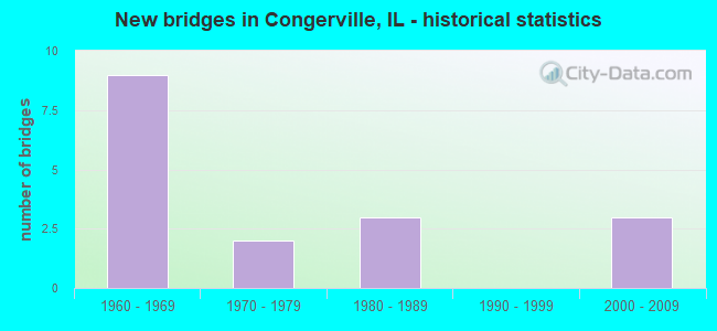
- New bridges - historical statistics
- 91960-1969
- 21970-1979
- 31980-1989
- 32000-2009


- Bridge Condition - Deck
- 10.0%Good
- 50.0%Satisfactory
- 40.0%Fair

- Bridge Condition - Superstructure
- 10.0%Good
- 50.0%Satisfactory
- 40.0%Fair

- Bridge Condition - Substructure
- 20.0%Very good
- 30.0%Good
- 20.0%Satisfactory
- 20.0%Fair
- 10.0%Poor

- Bridge Condition - Channel
- 36.4%Good
- 54.5%Satisfactory
- 9.1%Fair

- Bridge Condition - Culverts
- 75.0%Good
- 25.0%Fair
Find on map >> Show street view
Structure Number: 574019, Location: 5.0 MI W CARLOCK (Lat: 40.580419, Lng: -89.232808), Route carried "on" structure: County highway , Year Built: 1978, Status: Open, Structure Length: 0.79m (2.59ft), Average Daily Traffic: 25 (year 2020), Average Future Daily Traffic: 32 (year 2032), Design Load: HS 20, Features Intersected: BRANCH ROCK CREEK, Facility Carried by Structure: TR 149
Minimum Vertical Clearance: 30+ m (98+ ft), Kilometerpoint: 1.078, Lanes on structure: 2, Owner: Town or Township Highway Agency, Approaching Roadway Width: 7.3m (24.0ft), Material/Design: Concrete continuous, Design/Construction: Culvert, Number Of Spans In Main Unit: 2, Length of Maximum Span: 3.7m (12.1ft)
Condition: Channel: Satisfactory, Culverts: Good, Operating Rating: 44.4 metric tons, Method Used To Determine Operating Rating: Assigned rating based on Load Factor Design (LFD) reported by rating factor (RF) using MS18 loading, Inventory Rating: 32.4 metric tons, Method Used To Determine Inventory Rating: Assigned rating based on Load Factor Design (LFD) reported by rating factor (RF) using MS18 loading, Structural Evaluation: Better than present minimum criteria, Waterway Adequacy: Equal to present desirable criteria, Approach Roadway Alignment: Equal to present desirable criteria, Designated Inspection Frequency: Every 48 months, Inspection Date: March 2020
Find on map >> Show street view
Structure Number: 574021, Location: 2.0 MI NW CARLOCK (Lat: 40.594517, Lng: -89.174189), Route carried "on" structure: County highway , Year Built: 1980, Status: Open, Structure Length: 2.07m (6.79ft), Average Daily Traffic: 100 (year 2020), Average Future Daily Traffic: 84 (year 2032), Design Load: HS 20, Features Intersected: ROCK CREEK, Facility Carried by Structure: TR 56
Minimum Vertical Clearance: 30+ m (98+ ft), Kilometerpoint: 0.161, Lanes on structure: 2, Owner: Town or Township Highway Agency, Approaching Roadway Width: 4.3m (14.1ft), Material/Design: Concrete continuous, Design/Construction: Slab, Number Of Spans In Main Unit: 3, Length of Maximum Span: 7.6m (24.9ft), Curb-To-Curb Width: 7.5m (24.6ft), Out-to-Out Width: 7.9m (25.9ft)
Condition: Deck: Good, Superstructure: Good, Substructure: Fair, Channel: Good, Operating Rating: 44.4 metric tons, Method Used To Determine Operating Rating: Assigned rating based on Load Factor Design (LFD) reported by rating factor (RF) using MS18 loading, Inventory Rating: 32.4 metric tons, Method Used To Determine Inventory Rating: Assigned rating based on Load Factor Design (LFD) reported by rating factor (RF) using MS18 loading, Structural Evaluation: Somewhat better than minimum adequacy, Deck Geometry: Equal to present minimum criteria, Waterway Adequacy: Equal to present desirable criteria, Approach Roadway Alignment: Equal to present desirable criteria, Designated Inspection Frequency: Every 24 months, Inspection Date: March 2020, Deck Structure Type: Concrete Cast-file-Place
Find on map >> Show street view
Structure Number: 574024, Location: 5.0 MI WNW CARLOCK (Lat: 40.593153, Lng: -89.221625), Route carried "on" structure: County highway , Year Built: 1988, Status: Open, Structure Length: 3.35m (10.99ft), Average Daily Traffic: 150 (year 2020), Truck Traffic: 33%, Average Future Daily Traffic: 140 (year 2032), Design Load: HS 20, Features Intersected: ROCK CREEK, Facility Carried by Structure: TR 36
Minimum Vertical Clearance: 30+ m (98+ ft), Kilometerpoint: 0.225, Lanes on structure: 2, Owner: Town or Township Highway Agency, Approaching Roadway Width: 8.5m (27.9ft), Material/Design: Concrete continuous, Design/Construction: Slab, Number Of Spans In Main Unit: 3, Length of Maximum Span: 13.1m (43.0ft), Curb-To-Curb Width: 7.5m (24.6ft), Out-to-Out Width: 7.9m (25.9ft)
Condition: Deck: Satisfactory, Superstructure: Satisfactory, Substructure: Very good, Channel: Good, Operating Rating: 44.4 metric tons, Method Used To Determine Operating Rating: Assigned rating based on Load Factor Design (LFD) reported by rating factor (RF) using MS18 loading, Inventory Rating: 32.4 metric tons, Method Used To Determine Inventory Rating: Assigned rating based on Load Factor Design (LFD) reported by rating factor (RF) using MS18 loading, Structural Evaluation: Equal to present minimum criteria, Deck Geometry: Somewhat better than minimum adequacy, Waterway Adequacy: Equal to present desirable criteria, Approach Roadway Alignment: Equal to present desirable criteria, Designated Inspection Frequency: Every 24 months, Inspection Date: March 2020, Deck Structure Type: Concrete Cast-file-Place
Find on map >> Show street view
Structure Number: 574029, Location: 5.5 MI W CARLOCK (Lat: 40.580525, Lng: -89.221319), Route carried "on" structure: County highway , Year Built: 2001, Status: Open, Structure Length: 0.78m (2.56ft), Average Daily Traffic: 150 (year 2020), Truck Traffic: 33%, Average Future Daily Traffic: 140 (year 2032), Design Load: HS 20, Features Intersected: TRIB OF ROCK CREEK, Facility Carried by Structure: TR 36
Minimum Vertical Clearance: 30+ m (98+ ft), Kilometerpoint: 1.625, Lanes on structure: 2, Owner: Town or Township Highway Agency, Approaching Roadway Width: 7.3m (24.0ft), Material/Design: Concrete continuous, Design/Construction: Culvert, Number Of Spans In Main Unit: 2, Length of Maximum Span: 3.5m (11.5ft)
Condition: Channel: Fair, Culverts: Good, Operating Rating: 44.1 metric tons, Method Used To Determine Operating Rating: Assigned rating based on Load Factor Design (LFD) reported by rating factor (RF) using MS18 loading, Inventory Rating: 32.4 metric tons, Method Used To Determine Inventory Rating: Assigned rating based on Load Factor Design (LFD) reported by rating factor (RF) using MS18 loading, Structural Evaluation: Better than present minimum criteria, Waterway Adequacy: Equal to present desirable criteria, Approach Roadway Alignment: Equal to present desirable criteria, Designated Inspection Frequency: Every 48 months, Inspection Date: March 2020
Find on map >> Show street view
Structure Number: 574099, Location: 1.5 M NW OF CARLOCK (Lat: 40.588028, Lng: -89.174039), Route carried "on" structure: County highway , Year Built: 1971, Status: Open, Structure Length: 0.67m (2.20ft), Average Daily Traffic: 100 (year 2020), Average Future Daily Traffic: 84 (year 2032), Design Load: HS 15, Features Intersected: ROCK CREEK, Facility Carried by Structure: TR 56
Minimum Vertical Clearance: 30+ m (98+ ft), Kilometerpoint: 0.885, Lanes on structure: 2, Owner: Town or Township Highway Agency, Approaching Roadway Width: 4.3m (14.1ft), Material/Design: Concrete continuous, Design/Construction: Culvert, Number Of Spans In Main Unit: 2, Length of Maximum Span: 3.0m (9.8ft)
Condition: Channel: Satisfactory, Culverts: Good, Operating Rating: 43.7 metric tons, Method Used To Determine Operating Rating: Allowable Stress (AS) rating reported by rating factor (RF) method using MS18 loading, Inventory Rating: 26.2 metric tons, Method Used To Determine Inventory Rating: Allowable Stress (AS) rating reported by rating factor (RF) method using MS18 loading, Structural Evaluation: Equal to present minimum criteria, Waterway Adequacy: Equal to present desirable criteria, Approach Roadway Alignment: Equal to present desirable criteria, Designated Inspection Frequency: Every 24 months, Inspection Date: March 2020
Find on map >> Show street view
Structure Number: 1020003, Location: 3.85 MI E OF ILL 117 (Lat: 40.609811, Lng: -89.202981), Route carried "on" structure: Interstate 74, Year Built: 1964, Status: Open, Structure Length: 3.54m (11.61ft), Average Daily Traffic: 13,450 (year 2021), Truck Traffic: 19%, Average Future Daily Traffic: 14,397 (year 2032), Design Load: HS 20+Mod, Features Intersected: CONGERVILLE ROAD
Minimum Vertical Clearance: 30+ m (98+ ft), Kilometerpoint: 189.656, Lanes on structure: 2, Lanes under structure: 2, Base Highway Network: Yes, Owner: State Highway Agency, Approaching Roadway Width: 12.2m (40.0ft), Material/Design: Concrete continuous, Design/Construction: Slab, Number Of Spans In Main Unit: 3, Length of Maximum Span: 13.4m (44.0ft), Curb-To-Curb Width: 11.9m (39.0ft), Out-to-Out Width: 13.5m (44.3ft)
Condition: Deck: Fair, Superstructure: Fair, Substructure: Fair, Operating Rating: 65.1 metric tons, Method Used To Determine Operating Rating: Load Factor (LF) rating reported by rating factor (RF) method using MS18 loading, Inventory Rating: 39.2 metric tons, Method Used To Determine Inventory Rating: Load Factor (LF) rating reported by rating factor (RF) method using MS18 loading, Structural Evaluation: Somewhat better than minimum adequacy, Deck Geometry: Equal to present minimum criteria, Underclear: Equal to present minimum criteria, Approach Roadway Alignment: Equal to present desirable criteria, Designated Inspection Frequency: Every 24 months, Inspection Date: December 2019, Deck Structure Type: Concrete Cast-file-Place, Wearing Surface/Protective System: Wearing Surface: Latex Concrete
Find on map >> Show street view
Structure Number: 1020004, Location: 3.85 MI E OF ILL 117 (Lat: 40.609811, Lng: -89.202792), Route carried "on" structure: Interstate 74, Year Built: 1964, Year Reconstructed: 1995, Status: Open, Structure Length: 3.54m (11.61ft), Average Daily Traffic: 13,450 (year 2021), Truck Traffic: 19%, Average Future Daily Traffic: 14,397 (year 2032), Design Load: HS 20+Mod, Features Intersected: CONGERVILLE ROAD
Minimum Vertical Clearance: 30+ m (98+ ft), Kilometerpoint: 189.672, Lanes on structure: 2, Lanes under structure: 2, Base Highway Network: Yes, Owner: State Highway Agency, Approaching Roadway Width: 12.2m (40.0ft), Material/Design: Concrete continuous, Design/Construction: Slab, Number Of Spans In Main Unit: 3, Length of Maximum Span: 13.4m (44.0ft), Curb-To-Curb Width: 11.9m (39.0ft), Out-to-Out Width: 13.5m (44.3ft)
Condition: Deck: Fair, Superstructure: Fair, Substructure: Good, Operating Rating: 65.1 metric tons, Method Used To Determine Operating Rating: Load Factor (LF) rating reported by rating factor (RF) method using MS18 loading, Inventory Rating: 39.2 metric tons, Method Used To Determine Inventory Rating: Load Factor (LF) rating reported by rating factor (RF) method using MS18 loading, Structural Evaluation: Somewhat better than minimum adequacy, Deck Geometry: Equal to present minimum criteria, Underclear: Equal to present minimum criteria, Approach Roadway Alignment: Equal to present desirable criteria, Designated Inspection Frequency: Every 24 months, Inspection Date: December 2019, Deck Structure Type: Concrete Cast-file-Place, Wearing Surface/Protective System: Wearing Surface: Latex Concrete
Find on map >> Show street view
Structure Number: 1020034, Location: 2.9 MI E OF ILL 117 (Lat: 40.609611, Lng: -89.222081), Route carried "on" structure: County highway , Year Built: 1964, Status: Open, Structure Length: 6.74m (22.11ft), Average Daily Traffic: 325 (year 2020), Truck Traffic: 9%, Average Future Daily Traffic: 495 (year 2032), Design Load: HS 15, Features Intersected: I-74, Facility Carried by Structure: COUNTY RD-TR 134
Minimum Vertical Clearance: 30+ m (98+ ft), Kilometerpoint: 0.370, Lanes on structure: 2, Lanes under structure: 4, Owner: State Highway Agency, Approaching Roadway Width: 9.1m (29.9ft), Material/Design: Steel continuous, Design/Construction: Stringer/Multi-beam, Number Of Spans In Main Unit: 4, Length of Maximum Span: 20.4m (66.9ft), Curb-To-Curb Width: 7.3m (24.0ft), Out-to-Out Width: 9.2m (30.2ft)
Condition: Deck: Satisfactory, Superstructure: Fair, Substructure: Satisfactory, Operating Rating: 46.7 metric tons, Method Used To Determine Operating Rating: Load Factor (LF) rating reported by rating factor (RF) method using MS18 loading, Inventory Rating: 27.9 metric tons, Method Used To Determine Inventory Rating: Load Factor (LF) rating reported by rating factor (RF) method using MS18 loading, Structural Evaluation: Somewhat better than minimum adequacy, Deck Geometry: Somewhat better than minimum adequacy, Underclear: High priority of corrective action, Approach Roadway Alignment: Equal to present minimum criteria, Length Of Structure Improvement: 6.74m (22.11ft), Designated Inspection Frequency: Every 24 months, Inspection Date: December 2019, Bridge Improvement Cost: $133,000, Roadway Improvement Cost: $7,000, Total Project Cost: $160,000, Deck Structure Type: Concrete Cast-file-Place
Find on map >> Show street view
Structure Number: 1022003, Location: .3 MI E CONGERVILLE (Lat: 40.609358, Lng: -89.192483), Route carried "on" structure: Interstate 74, Year Built: 1965, Status: Open, Structure Length: 0.69m (2.26ft), Average Daily Traffic: 26,900 (year 2021), Truck Traffic: 19%, Average Future Daily Traffic: 28,794 (year 2032), Design Load: H 20, Features Intersected: ROCK CREEK TRIBUTARY
Minimum Vertical Clearance: 30+ m (98+ ft), Kilometerpoint: 190.557, Lanes on structure: 4, Base Highway Network: Yes, Owner: State Highway Agency, Approaching Roadway Width: 23.2m (76.1ft), Material/Design: Concrete continuous, Design/Construction: Culvert, Number Of Spans In Main Unit: 2, Length of Maximum Span: 3.0m (9.8ft)
Condition: Channel: Satisfactory, Culverts: Fair, Operating Rating: 44.1 metric tons, Method Used To Determine Operating Rating: Load Factor (LF) rating reported by rating factor (RF) method using MS18 loading, Inventory Rating: 32.4 metric tons, Method Used To Determine Inventory Rating: Load Factor (LF) rating reported by rating factor (RF) method using MS18 loading, Structural Evaluation: Somewhat better than minimum adequacy, Waterway Adequacy: Superior to present desirable criteria, Approach Roadway Alignment: Equal to present desirable criteria, Designated Inspection Frequency: Every 24 months, Inspection Date: March 2020
Find on map >> Show street view
Structure Number: 1023017, Location: 3 MI N CONGERVILLE (Lat: 40.660267, Lng: -89.197561), Route carried "on" structure: County highway , Year Built: 1968, Status: Open, Structure Length: 13.20m (43.31ft), Average Daily Traffic: 550 (year 2020), Truck Traffic: 6%, Average Future Daily Traffic: 659 (year 2032), Design Load: HS 15, Features Intersected: Mackinaw River, Facility Carried by Structure: FAS-1359 (CH8)
Minimum Vertical Clearance: 30+ m (98+ ft), Kilometerpoint: 9.801, Lanes on structure: 2, Owner: County Highway Agency, Approaching Roadway Width: 10.4m (34.1ft), Skew: 1 degrees, Material/Design: Steel continuous, Design/Construction: Stringer/Multi-beam, Number Of Spans In Main Unit: 4, Length of Maximum Span: 36.6m (120.1ft), Curb-To-Curb Width: 7.9m (25.9ft), Out-to-Out Width: 9.0m (29.5ft)
Condition: Deck: Fair, Superstructure: Satisfactory, Substructure: Good, Channel: Satisfactory, Operating Rating: 42.8 metric tons, Method Used To Determine Operating Rating: Load Factor (LF) rating reported by rating factor (RF) method using MS18 loading, Inventory Rating: 25.6 metric tons, Method Used To Determine Inventory Rating: Load Factor (LF) rating reported by rating factor (RF) method using MS18 loading, Structural Evaluation: Equal to present minimum criteria, Deck Geometry: Somewhat better than minimum adequacy, Waterway Adequacy: Equal to present desirable criteria, Approach Roadway Alignment: Equal to present desirable criteria, Designated Inspection Frequency: Every 24 months, Inspection Date: June 2020, Deck Structure Type: Concrete Cast-file-Place, Wearing Surface/Protective System: Wearing Surface: Latex Concrete
Find on map >> Show street view
Structure Number: 1023109, Location: 75 N 1850 E (Lat: 40.599439, Lng: -89.183844), Route carried "on" structure: County highway , Year Built: 1965, Status: Posted for load, Structure Length: 2.47m (8.10ft), Average Daily Traffic: 100 (year 2020), Average Future Daily Traffic: 110 (year 2032), Design Load: HS 15, Features Intersected: Rock Creek, Facility Carried by Structure: TR 271
Minimum Vertical Clearance: 30+ m (98+ ft), Kilometerpoint: 1.593, Lanes on structure: 2, Owner: Town or Township Highway Agency, Approaching Roadway Width: 6.7m (22.0ft), Material/Design: Concrete continuous, Design/Construction: Slab, Number Of Spans In Main Unit: 3, Length of Maximum Span: 9.1m (29.9ft), Curb-To-Curb Width: 7.3m (24.0ft), Out-to-Out Width: 8.5m (27.9ft)
Condition: Deck: Satisfactory, Superstructure: Satisfactory, Substructure: Poor, Channel: Good, Operating Rating: 38.2 metric tons, Method Used To Determine Operating Rating: Load Factor (LF) rating reported by rating factor (RF) method using MS18 loading, Inventory Rating: 23.0 metric tons, Method Used To Determine Inventory Rating: Load Factor (LF) rating reported by rating factor (RF) method using MS18 loading, Structural Evaluation: Meets minimum limits, Deck Geometry: Equal to present minimum criteria, Waterway Adequacy: Equal to present desirable criteria, Approach Roadway Alignment: Equal to present desirable criteria, Bridge Posting: Required (Relationship of Operating Rating to Maximum Legal Load: 30.0 - 39.9% below), Designated Inspection Frequency: Every 24 months, Inspection Date: Febuary 2021, Deck Structure Type: Concrete Cast-file-Place, Wearing Surface/Protective System: Wearing Surface: Gravel
Find on map >> Show street view
Structure Number: 1023171, Location: 340 N 2050 E (Lat: 40.639083, Lng: -89.145953), Route carried "on" structure: County highway , Year Built: 1989, Status: Open, Structure Length: 0.99m (3.25ft), Average Daily Traffic: 75 (year 2020), Average Future Daily Traffic: 82 (year 2032), Design Load: HS 20, Features Intersected: VINCENT RUN, Facility Carried by Structure: TR168A (Denman Rd)
Minimum Vertical Clearance: 30+ m (98+ ft), Kilometerpoint: 0.016, Lanes on structure: 2, Owner: Town or Township Highway Agency, Approaching Roadway Width: 8.5m (27.9ft), Material/Design: Concrete, Design/Construction: Slab, Number Of Spans In Main Unit: 1, Length of Maximum Span: 9.9m (32.5ft), Curb-To-Curb Width: 8.5m (27.9ft), Out-to-Out Width: 8.5m (27.9ft)
Condition: Deck: Satisfactory, Superstructure: Satisfactory, Substructure: Satisfactory, Channel: Satisfactory, Operating Rating: 44.1 metric tons, Method Used To Determine Operating Rating: Assigned rating based on Load Factor Design (LFD) reported by rating factor (RF) using MS18 loading, Inventory Rating: 32.4 metric tons, Method Used To Determine Inventory Rating: Assigned rating based on Load Factor Design (LFD) reported by rating factor (RF) using MS18 loading, Structural Evaluation: Equal to present minimum criteria, Deck Geometry: Better than present minimum criteria, Waterway Adequacy: Equal to present desirable criteria, Approach Roadway Alignment: Equal to present minimum criteria, Designated Inspection Frequency: Every 24 months, Inspection Date: Febuary 2021, Deck Structure Type: Concrete Precast Panels
Find on map >> Show street view
Structure Number: 1023188, Location: .11 MI N TR 271 (Lat: 40.600958, Lng: -89.187256), Route carried "on" structure: County highway , Year Built: 2003, Status: Open, Structure Length: 1.86m (6.10ft), Average Daily Traffic: 50 (year 2020), Average Future Daily Traffic: 55 (year 2032), Design Load: HS 20, Features Intersected: ROCK CREEK, Facility Carried by Structure: TR 150A
Minimum Vertical Clearance: 30+ m (98+ ft), Kilometerpoint: 0.933, Lanes on structure: 2, Owner: Town or Township Highway Agency, Approaching Roadway Width: 7.9m (25.9ft), Material/Design: Prestressed concrete, Design/Construction: Box Beam or Girders - Multiple, Number Of Spans In Main Unit: 1, Length of Maximum Span: 18.6m (61.0ft), Curb-To-Curb Width: 8.2m (26.9ft), Out-to-Out Width: 8.2m (26.9ft)
Condition: Deck: Satisfactory, Superstructure: Satisfactory, Substructure: Very good, Channel: Good, Operating Rating: 44.1 metric tons, Method Used To Determine Operating Rating: Assigned rating based on Load Factor Design (LFD) reported by rating factor (RF) using MS18 loading, Inventory Rating: 32.4 metric tons, Method Used To Determine Inventory Rating: Assigned rating based on Load Factor Design (LFD) reported by rating factor (RF) using MS18 loading, Structural Evaluation: Equal to present minimum criteria, Deck Geometry: Equal to present minimum criteria, Waterway Adequacy: Equal to present desirable criteria, Approach Roadway Alignment: Better than present minimum criteria, Designated Inspection Frequency: Every 24 months, Inspection Date: Febuary 2021, Deck Structure Type: Concrete Precast Panels, Wearing Surface/Protective System: Wearing Surface: Gravel
Find on map >> Show street view
Structure Number: 1023191, Location: .3 MIL S OF CONGERVL (Lat: 40.608561, Lng: -89.202967), Route carried "on" structure: County highway , Year Built: 2001, Status: Open, Structure Length: 2.98m (9.78ft), Average Daily Traffic: 350 (year 2020), Truck Traffic: 10%, Average Future Daily Traffic: 495 (year 2032), Design Load: HS 20, Features Intersected: ROCK CREEK, Facility Carried by Structure: FAS 360
Minimum Vertical Clearance: 30+ m (98+ ft), Kilometerpoint: 1.046, Lanes on structure: 2, Owner: County Highway Agency, Approaching Roadway Width: 9.1m (29.9ft), Material/Design: Concrete, Design/Construction: Channel Beam, Number Of Spans In Main Unit: 3, Length of Maximum Span: 11.5m (37.7ft), Curb-To-Curb Width: 6.7m (22.0ft), Out-to-Out Width: 9.1m (29.9ft)
Condition: Deck: Fair, Superstructure: Fair, Substructure: Good, Channel: Satisfactory, Operating Rating: 52.2 metric tons, Method Used To Determine Operating Rating: Load Factor (LF) rating reported by rating factor (RF) method using MS18 loading, Inventory Rating: 31.1 metric tons, Method Used To Determine Inventory Rating: Load Factor (LF) rating reported by rating factor (RF) method using MS18 loading, Structural Evaluation: Somewhat better than minimum adequacy, Deck Geometry: Meets minimum limits, Waterway Adequacy: Equal to present desirable criteria, Approach Roadway Alignment: Equal to present desirable criteria, Designated Inspection Frequency: Every 24 months, Inspection Date: June 2020, Deck Structure Type: Concrete Precast Panels, Wearing Surface/Protective System: Wearing Surface: Gravel, Membrane: Built-up
Find on map >> Show street view
Structure Number: 1020003, Location: 3.85 MI E OF ILL 117 (Lat: 40.609675, Lng: -89.202981), Route carried "under" structure: County highway , Year Built: 1964, Structure Length: 0. m, Average Daily Traffic: 350 (year 2020), Truck Traffic: 10%, Features Intersected: CONGERVILLE ROAD, Facility Carried by Structure: EB I-74
Minimum Vertical Clearance: 4.47m (14.67ft), Kilometerpoint: 0.917, Lanes on structure: 2, Lanes under structure: 2, Material/Design: Concrete continuous, Design/Construction: Slab, Length of Maximum Span: 13.4m (44.0ft)
Find on map >> Show street view
Structure Number: 1020004, Location: 3.85 MI E OF ILL 117 (Lat: 40.609933, Lng: -89.202986), Route carried "under" structure: County highway , Year Built: 1964, Structure Length: 0. m, Average Daily Traffic: 350 (year 2020), Truck Traffic: 10%, Features Intersected: CONGERVILLE ROAD, Facility Carried by Structure: WB I-74
Minimum Vertical Clearance: 4.47m (14.67ft), Kilometerpoint: 0.885, Lanes on structure: 2, Lanes under structure: 2, Material/Design: Concrete continuous, Design/Construction: Slab, Length of Maximum Span: 13.4m (44.0ft)
Find on map >> Show street view
Structure Number: 1020034, Location: 2.9 MI E OF ILL 117 (Lat: 40.609611, Lng: -89.222081), Route carried "under" structure: Interstate 74, Year Built: 1964, Structure Length: 0. m, Average Daily Traffic: 26,900 (year 2021), Truck Traffic: 19%, Features Intersected: I-74, Facility Carried by Structure: COUNTY RD-TR 134
Minimum Vertical Clearance: 4.83m (15.85ft), Kilometerpoint: 188.063, Lanes on structure: 2, Lanes under structure: 4, Material/Design: Steel continuous, Design/Construction: Stringer/Multi-beam, Length of Maximum Span: 20.4m (66.9ft)