Bridge Statistics for Cordova, Alaska (AK)
Condition, Traffic, Stress, Structural Evaluation, Project Costs
- National Bridge Inventory (NBI) Statistics
- 23Number of bridges
- 896ft / 273mTotal length
- $16,000,000Total costs
- 4,928Total average daily traffic
- 542Total average daily truck traffic
- 7,387Total future (year 2030) average daily traffic
- National Bridge Inventory (NBI) Registered Bridges for Cordova
- No street view available for this location
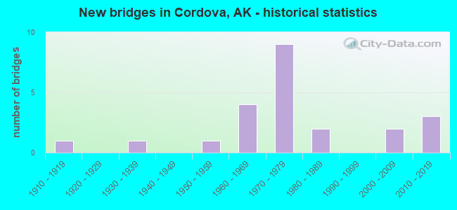
- New bridges - historical statistics
- 11910-1919
- 11930-1939
- 11950-1959
- 41960-1969
- 91970-1979
- 21980-1989
- 22000-2009
- 32010-2019
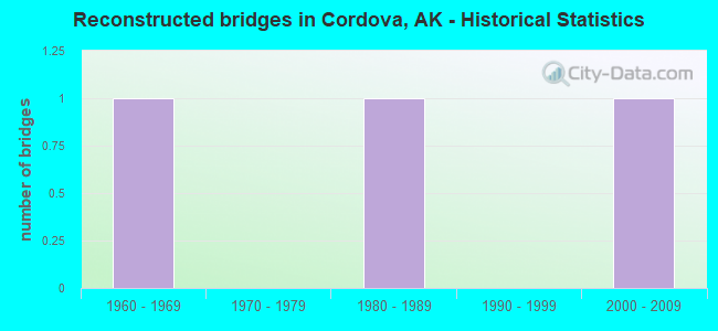
- Reconstructed bridges - Historical Statistics
- 11960-1969
- 01970-1979
- 11980-1989
- 01990-1999
- 12000-2009
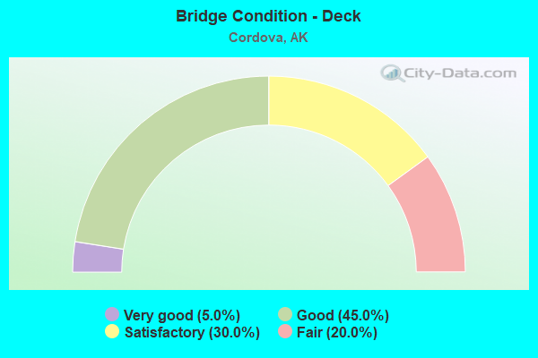
- Bridge Condition - Deck
- 5.0%Very good
- 45.0%Good
- 30.0%Satisfactory
- 20.0%Fair
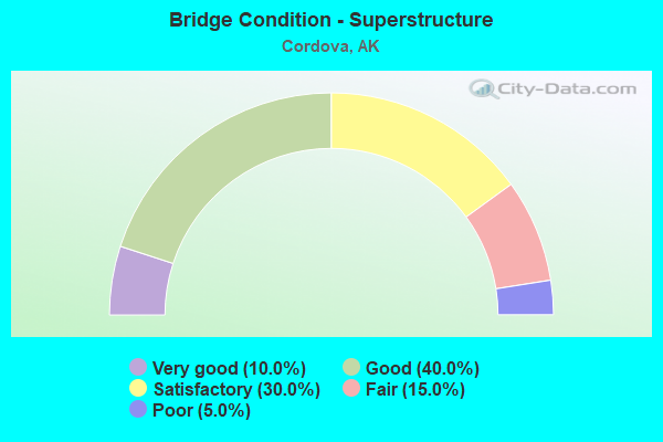
- Bridge Condition - Superstructure
- 10.0%Very good
- 40.0%Good
- 30.0%Satisfactory
- 15.0%Fair
- 5.0%Poor
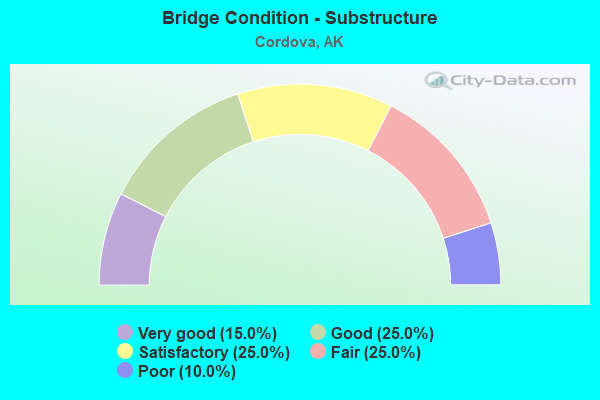
- Bridge Condition - Substructure
- 15.0%Very good
- 25.0%Good
- 25.0%Satisfactory
- 25.0%Fair
- 10.0%Poor
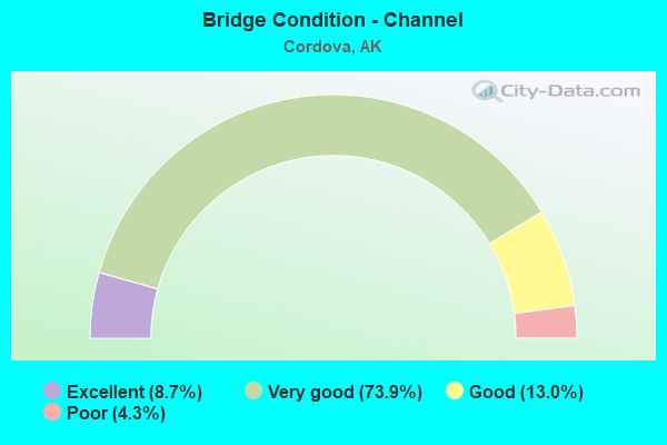
- Bridge Condition - Channel
- 8.7%Excellent
- 73.9%Very good
- 13.0%Good
- 4.3%Poor
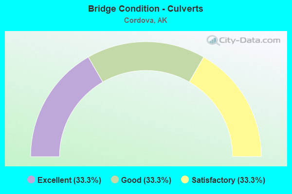
- Bridge Condition - Culverts
- 33.3%Excellent
- 33.3%Good
- 33.3%Satisfactory
Find on map >> Show street view
Structure Number: 18, Location: CORDOVA (Lat: 60.557303, Lng: -145.754900), Route carried "on" structure: State highway 851, Year Built: 2004, Status: Open, Structure Length: 13.41m (44.00ft), Average Daily Traffic: 100 (year 2018), Truck Traffic: 6%, Average Future Daily Traffic: 110 (year 2035), Design Load: HS 20, Features Intersected: CORDOVA FERRY TERMINAL, Facility Carried by Structure: FERRY TERMINAL RD
Minimum Vertical Clearance: 30+ m (98+ ft), Kilometerpoint: 0.161, Lanes on structure: 1, Toll: On toll road, Owner: State Highway Agency, Approaching Roadway Width: 6.1m (20.0ft), Material/Design: Steel, Design/Construction: Box Beam or Girders - Multiple, Number Of Spans In Main Unit: 1, Number Of Approach Spans: 1, Length of Maximum Span: 42.1m (138.1ft), Curb or Sidewalk Widths: Left: 1.8m (5.9ft), Right: 0.0m, Curb-To-Curb Width: 4.1m (13.5ft), Out-to-Out Width: 6.1m (20.0ft)
Condition: Deck: Good, Superstructure: Fair, Substructure: Satisfactory, Channel: Excellent, Operating Rating: 53.9 metric tons, Method Used To Determine Operating Rating: Load Factor (LF), Inventory Rating: 32.0 metric tons, Method Used To Determine Inventory Rating: Load Factor (LF), Structural Evaluation: Somewhat better than minimum adequacy, Deck Geometry: Somewhat better than minimum adequacy, Waterway Adequacy: Superior to present desirable criteria, Approach Roadway Alignment: Better than present minimum criteria, Designated Inspection Frequency: Every 24 months, Critical Feature Inspection Frequency: Every 24 months, Underwater Inspection Frequency: Every 60 months, Inspection Date: July 2021, Critical Feature Inspection Date: July 2021, Underwater Inspection Date: June 2021, Deck Structure Type: Open Grating, Wearing Surface/Protective System: Deck Protection: Other
Find on map >> Show street view
Structure Number: 206, Location: MILE POINT 48.8 (Lat: 60.673075, Lng: -144.745867), Route carried "on" structure: State highway 851, Year Built: 1910, Year Reconstructed: 2005, Status: Closed, Structure Length: 47.75m (156.66ft), Average Daily Traffic: 65 (year 2011), Truck Traffic: 1%, Average Future Daily Traffic: 150 (year 2030), Design Load: HS 15, Features Intersected: MILLION DOLLAR BRIDGE, Facility Carried by Structure: COPPER RIVER HWY
Minimum Vertical Clearance: 6.10m (20.01ft), Kilometerpoint: 78.519, Lanes on structure: 1, Owner: State Highway Agency, Approaching Roadway Width: 5.5m (18.0ft), Material/Design: Steel, Design/Construction: Truss - Thru, Number Of Spans In Main Unit: 4, Length of Maximum Span: 137.2m (450.1ft), Curb or Sidewalk Widths: Left: 0.3m (1.0ft), Right: 0.3m (1.0ft), Curb-To-Curb Width: 5.5m (18.0ft), Out-to-Out Width: 6.1m (20.0ft)
Condition: Deck: Good, Superstructure: Fair, Substructure: Poor, Channel: Good, Operating Rating: 50.2 metric tons, Method Used To Determine Operating Rating: Load Factor (LF), Inventory Rating: 23.2 metric tons, Method Used To Determine Inventory Rating: Load Factor (LF), Structural Evaluation: Meets minimum limits, Deck Geometry: Meets minimum limits, Waterway Adequacy: Superior to present desirable criteria, Approach Roadway Alignment: Equal to present desirable criteria, Designated Inspection Frequency: Every 24 months, Critical Feature Inspection Frequency: Every 24 months, Underwater Inspection Frequency: Every 60 months, Inspection Date: August 2010, Critical Feature Inspection Date: September 2010, Underwater Inspection Date: September 2019, Bridge Improvement Cost: $13,440,000, Total Project Cost: $16,000,000, Deck Structure Type: Concrete Cast-file-Place, Wearing Surface/Protective System: Wearing Surface: Monolithic Concrete
Find on map >> Show street view
Structure Number: 331, Location: MILE POINT 26.7 (Lat: 60.445456, Lng: -145.083422), Route carried "on" structure: State highway 851, Year Built: 1973, Status: Open, Structure Length: 23.94m (78.54ft), Average Daily Traffic: 40 (year 2020), Truck Traffic: 8%, Average Future Daily Traffic: 50 (year 2039), Design Load: HS 20, Features Intersected: COPPER RIV (FLAG PT WST), Facility Carried by Structure: COPPER RIVER HWY
Minimum Vertical Clearance: 6.10m (20.01ft), Kilometerpoint: 42.944, Lanes on structure: 2, Owner: State Highway Agency, Approaching Roadway Width: 9.1m (29.9ft), Material/Design: Steel continuous, Design/Construction: Stringer/Multi-beam, Number Of Spans In Main Unit: 4, Length of Maximum Span: 67.1m (220.1ft), Curb-To-Curb Width: 9.1m (29.9ft), Out-to-Out Width: 10.0m (32.8ft)
Condition: Deck: Fair, Superstructure: Satisfactory, Substructure: Fair, Channel: Very good, Operating Rating: 69.6 metric tons, Method Used To Determine Operating Rating: Load Factor (LF), Inventory Rating: 23.0 metric tons, Method Used To Determine Inventory Rating: Load Factor (LF), Structural Evaluation: Somewhat better than minimum adequacy, Deck Geometry: Better than present minimum criteria, Waterway Adequacy: Superior to present desirable criteria, Approach Roadway Alignment: Equal to present desirable criteria, Designated Inspection Frequency: Every 24 months, Critical Feature Inspection Frequency: Every 24 months, Underwater Inspection Frequency: Every 60 months, Inspection Date: August 2020, Critical Feature Inspection Date: July 2021, Underwater Inspection Date: June 2021, Deck Structure Type: Concrete Cast-file-Place, Wearing Surface/Protective System: Wearing Surface: Monolithic Concrete
Find on map >> Show street view
Structure Number: 332, Location: MILE POINT 27.6 (Lat: 60.445375, Lng: -145.056836), Route carried "on" structure: State highway 851, Year Built: 1973, Status: Open, Structure Length: 23.94m (78.54ft), Average Daily Traffic: 40 (year 2020), Truck Traffic: 8%, Average Future Daily Traffic: 50 (year 2039), Design Load: HS 20+Mod, Features Intersected: COPPER RIV (RND ISLAND), Facility Carried by Structure: COPPER RIVER HWY
Minimum Vertical Clearance: 6.10m (20.01ft), Kilometerpoint: 44.439, Lanes on structure: 2, Owner: State Highway Agency, Approaching Roadway Width: 9.1m (29.9ft), Material/Design: Steel continuous, Design/Construction: Stringer/Multi-beam, Number Of Spans In Main Unit: 4, Length of Maximum Span: 67.1m (220.1ft), Curb-To-Curb Width: 9.1m (29.9ft), Out-to-Out Width: 10.0m (32.8ft)
Condition: Deck: Satisfactory, Superstructure: Satisfactory, Substructure: Very good, Channel: Very good, Operating Rating: 69.6 metric tons, Method Used To Determine Operating Rating: Load Factor (LF), Inventory Rating: 23.0 metric tons, Method Used To Determine Inventory Rating: Load Factor (LF), Structural Evaluation: Equal to present minimum criteria, Deck Geometry: Better than present minimum criteria, Waterway Adequacy: Superior to present desirable criteria, Approach Roadway Alignment: Equal to present desirable criteria, Designated Inspection Frequency: Every 24 months, Critical Feature Inspection Frequency: Every 24 months, Inspection Date: August 2020, Critical Feature Inspection Date: July 2021, Deck Structure Type: Concrete Cast-file-Place, Wearing Surface/Protective System: Wearing Surface: Monolithic Concrete
Find on map >> Show street view
Structure Number: 333, Location: MILE POINT 33.7 (Lat: 60.501200, Lng: -144.923472), Route carried "on" structure: State highway 851, Year Built: 1977, Status: Open, Structure Length: 7.35m (24.11ft), Average Daily Traffic: 40 (year 2020), Truck Traffic: 8%, Average Future Daily Traffic: 50 (year 2039), Design Load: HS 20, Features Intersected: COPPER DELTA, Facility Carried by Structure: COPPER RIVER HWY
Minimum Vertical Clearance: 6.10m (20.01ft), Kilometerpoint: 54.256, Lanes on structure: 2, Owner: State Highway Agency, Approaching Roadway Width: 8.8m (28.9ft), Material/Design: Prestressed concrete, Design/Construction: Tee Beam, Number Of Spans In Main Unit: 3, Length of Maximum Span: 24.4m (80.1ft), Curb-To-Curb Width: 8.5m (27.9ft), Out-to-Out Width: 9.3m (30.5ft)
Condition: Deck: Good, Superstructure: Good, Substructure: Satisfactory, Channel: Very good, Operating Rating: 74.5 metric tons, Method Used To Determine Operating Rating: Load Factor (LF), Inventory Rating: 34.3 metric tons, Method Used To Determine Inventory Rating: Load Factor (LF), Structural Evaluation: Equal to present minimum criteria, Deck Geometry: Better than present minimum criteria, Waterway Adequacy: Superior to present desirable criteria, Approach Roadway Alignment: Equal to present desirable criteria, Designated Inspection Frequency: Every 24 months, Underwater Inspection Frequency: Every 60 months, Inspection Date: August 2020, Underwater Inspection Date: June 2021, Deck Structure Type: Concrete Precast Panels, Wearing Surface/Protective System: Wearing Surface: Monolithic Concrete
Find on map >> Show street view
Structure Number: 334, Location: MILE POINT 34.6 (Lat: 60.508822, Lng: -144.898500), Route carried "on" structure: State highway 851, Year Built: 1977, Status: Open, Structure Length: 36.61m (120.11ft), Average Daily Traffic: 40 (year 2020), Truck Traffic: 8%, Average Future Daily Traffic: 50 (year 2039), Design Load: HS 20+Mod, Features Intersected: COPPER DELTA, Facility Carried by Structure: COPPER RIVER HWY
Minimum Vertical Clearance: 6.10m (20.01ft), Kilometerpoint: 55.717, Lanes on structure: 2, Owner: State Highway Agency, Approaching Roadway Width: 8.8m (28.9ft), Material/Design: Prestressed concrete, Design/Construction: Tee Beam, Number Of Spans In Main Unit: 15, Length of Maximum Span: 24.4m (80.1ft), Curb-To-Curb Width: 8.5m (27.9ft), Out-to-Out Width: 9.4m (30.8ft)
Condition: Deck: Satisfactory, Superstructure: Satisfactory, Substructure: Satisfactory, Channel: Very good, Operating Rating: 74.5 metric tons, Method Used To Determine Operating Rating: Load Factor (LF), Inventory Rating: 34.3 metric tons, Method Used To Determine Inventory Rating: Load Factor (LF), Structural Evaluation: Equal to present minimum criteria, Deck Geometry: Better than present minimum criteria, Waterway Adequacy: Equal to present minimum criteria, Approach Roadway Alignment: Equal to present desirable criteria, Designated Inspection Frequency: Every 24 months, Underwater Inspection Frequency: Every 60 months, Inspection Date: August 2020, Underwater Inspection Date: June 2021, Deck Structure Type: Concrete Precast Panels, Wearing Surface/Protective System: Wearing Surface: Monolithic Concrete
Find on map >> Show street view
Structure Number: 336, Location: MILE POINT 35.6 (Lat: 60.514089, Lng: -144.874728), Route carried "on" structure: State highway 851, Year Built: 1977, Status: Open, Structure Length: 7.35m (24.11ft), Average Daily Traffic: 40 (year 2020), Truck Traffic: 8%, Average Future Daily Traffic: 50 (year 2039), Design Load: HS 20+Mod, Features Intersected: COPPER DELTA, Facility Carried by Structure: COPPER RIVER HWY
Minimum Vertical Clearance: 6.10m (20.01ft), Kilometerpoint: 57.296, Lanes on structure: 2, Owner: State Highway Agency, Approaching Roadway Width: 8.7m (28.5ft), Material/Design: Prestressed concrete, Design/Construction: Tee Beam, Number Of Spans In Main Unit: 3, Length of Maximum Span: 24.4m (80.1ft), Curb-To-Curb Width: 8.5m (27.9ft), Out-to-Out Width: 8.8m (28.9ft)
Condition: Deck: Good, Superstructure: Good, Substructure: Good, Channel: Very good, Operating Rating: 74.5 metric tons, Method Used To Determine Operating Rating: Load Factor (LF), Inventory Rating: 34.3 metric tons, Method Used To Determine Inventory Rating: Load Factor (LF), Structural Evaluation: Better than present minimum criteria, Deck Geometry: Better than present minimum criteria, Waterway Adequacy: Equal to present minimum criteria, Approach Roadway Alignment: Equal to present desirable criteria, Designated Inspection Frequency: Every 24 months, Inspection Date: August 2020, Deck Structure Type: Concrete Precast Panels, Wearing Surface/Protective System: Wearing Surface: Monolithic Concrete
Find on map >> Show street view
Structure Number: 342, Location: MILE POINT 37.0 (Lat: 60.521467, Lng: -144.834744), Route carried "on" structure: State highway 851, Year Built: 1977, Year Reconstructed: 1988, Status: Closed, Structure Length: 26.83m (88.02ft), Average Daily Traffic: 94 (year 2011), Truck Traffic: 1%, Average Future Daily Traffic: 150 (year 2030), Design Load: HS 20+Mod, Features Intersected: COPPER DELTA, Facility Carried by Structure: COPPER RIVER HWY
Minimum Vertical Clearance: 6.10m (20.01ft), Kilometerpoint: 59.536, Lanes on structure: 2, Owner: State Highway Agency, Approaching Roadway Width: 8.8m (28.9ft), Material/Design: Prestressed concrete, Design/Construction: Tee Beam, Number Of Spans In Main Unit: 11, Length of Maximum Span: 24.4m (80.1ft), Curb-To-Curb Width: 8.5m (27.9ft), Out-to-Out Width: 8.8m (28.9ft)
Condition: Deck: Good, Superstructure: Good, Substructure: Satisfactory, Channel: Very good, Operating Rating: 69.7 metric tons, Method Used To Determine Operating Rating: Load Factor (LF), Inventory Rating: 32.1 metric tons, Method Used To Determine Inventory Rating: Load Factor (LF), Structural Evaluation: Equal to present minimum criteria, Deck Geometry: Better than present minimum criteria, Waterway Adequacy: Equal to present minimum criteria, Approach Roadway Alignment: Equal to present desirable criteria, Designated Inspection Frequency: Every 24 months, Underwater Inspection Frequency: Every 60 months, Inspection Date: August 2010, Deck Structure Type: Concrete Precast Panels, Wearing Surface/Protective System: Wearing Surface: Monolithic Concrete
Find on map >> Show street view
Structure Number: 344, Location: MILE POINT 37.6 (Lat: 60.524369, Lng: -144.818983), Route carried "on" structure: State highway 851, Year Built: 1977, Status: Closed, Structure Length: 12.22m (40.09ft), Average Daily Traffic: 94 (year 2011), Truck Traffic: 1%, Average Future Daily Traffic: 150 (year 2030), Design Load: HS 20+Mod, Features Intersected: COPPER DELTA, Facility Carried by Structure: COPPER RIVER HWY
Minimum Vertical Clearance: 6.10m (20.01ft), Kilometerpoint: 60.530, Lanes on structure: 2, Owner: State Highway Agency, Approaching Roadway Width: 8.2m (26.9ft), Material/Design: Prestressed concrete, Design/Construction: Tee Beam, Number Of Spans In Main Unit: 5, Length of Maximum Span: 24.4m (80.1ft), Curb-To-Curb Width: 8.5m (27.9ft), Out-to-Out Width: 8.8m (28.9ft)
Condition: Deck: Good, Superstructure: Good, Substructure: Good, Channel: Very good, Operating Rating: 74.5 metric tons, Method Used To Determine Operating Rating: Load Factor (LF), Inventory Rating: 34.3 metric tons, Method Used To Determine Inventory Rating: Load Factor (LF), Structural Evaluation: Better than present minimum criteria, Deck Geometry: Better than present minimum criteria, Waterway Adequacy: Equal to present desirable criteria, Approach Roadway Alignment: Equal to present desirable criteria, Designated Inspection Frequency: Every 24 months, Inspection Date: August 2010, Deck Structure Type: Concrete Precast Panels, Wearing Surface/Protective System: Wearing Surface: Monolithic Concrete
Find on map >> Show street view
Structure Number: 349, Location: MILE POINT 7.6 (Lat: 60.519822, Lng: -145.593183), Route carried "on" structure: State highway 851, Year Built: 1966, Status: Open, Structure Length: 6.46m (21.19ft), Average Daily Traffic: 520 (year 2020), Truck Traffic: 17%, Average Future Daily Traffic: 630 (year 2039), Design Load: HS 20+Mod, Features Intersected: SCOTT GLACIER NO 2, Facility Carried by Structure: COPPER RIVER HWY
Minimum Vertical Clearance: 6.10m (20.01ft), Kilometerpoint: 12.254, Lanes on structure: 2, Owner: State Highway Agency, Approaching Roadway Width: 8.2m (26.9ft), Material/Design: Steel, Design/Construction: Stringer/Multi-beam, Number Of Spans In Main Unit: 4, Length of Maximum Span: 18.3m (60.0ft), Curb-To-Curb Width: 8.6m (28.2ft), Out-to-Out Width: 9.0m (29.5ft)
Condition: Deck: Satisfactory, Superstructure: Satisfactory, Substructure: Satisfactory, Channel: Very good, Operating Rating: 63.0 metric tons, Method Used To Determine Operating Rating: Load Factor (LF), Inventory Rating: 29.0 metric tons, Method Used To Determine Inventory Rating: Load Factor (LF), Structural Evaluation: Equal to present minimum criteria, Deck Geometry: Somewhat better than minimum adequacy, Waterway Adequacy: Equal to present minimum criteria, Approach Roadway Alignment: Equal to present desirable criteria, Designated Inspection Frequency: Every 24 months, Inspection Date: August 2020, Deck Structure Type: Concrete Cast-file-Place, Wearing Surface/Protective System: Wearing Surface: Monolithic Concrete
Find on map >> Show street view
Structure Number: 351, Location: MILE POINT 8.5 (Lat: 60.514847, Lng: -145.570661), Route carried "on" structure: State highway 851, Year Built: 1966, Status: Open, Structure Length: 1.88m (6.17ft), Average Daily Traffic: 520 (year 2020), Truck Traffic: 17%, Average Future Daily Traffic: 630 (year 2039), Design Load: HS 20+Mod, Features Intersected: SCOTT GLACIER NO 4, Facility Carried by Structure: COPPER RIVER HWY
Minimum Vertical Clearance: 6.10m (20.01ft), Kilometerpoint: 13.626, Lanes on structure: 2, Owner: State Highway Agency, Approaching Roadway Width: 8.2m (26.9ft), Material/Design: Steel, Design/Construction: Stringer/Multi-beam, Number Of Spans In Main Unit: 1, Length of Maximum Span: 18.3m (60.0ft), Curb-To-Curb Width: 8.6m (28.2ft), Out-to-Out Width: 9.0m (29.5ft)
Condition: Deck: Satisfactory, Superstructure: Good, Substructure: Good, Channel: Very good, Operating Rating: 63.0 metric tons, Method Used To Determine Operating Rating: Load Factor (LF), Inventory Rating: 29.0 metric tons, Method Used To Determine Inventory Rating: Load Factor (LF), Structural Evaluation: Better than present minimum criteria, Deck Geometry: Somewhat better than minimum adequacy, Waterway Adequacy: Equal to present minimum criteria, Approach Roadway Alignment: Equal to present desirable criteria, Designated Inspection Frequency: Every 24 months, Inspection Date: August 2020, Deck Structure Type: Concrete Cast-file-Place, Wearing Surface/Protective System: Wearing Surface: Monolithic Concrete
Find on map >> Show street view
Structure Number: 352, Location: MILE POINT 9.2 (Lat: 60.510494, Lng: -145.550992), Route carried "on" structure: State highway 851, Year Built: 1966, Status: Open, Structure Length: 1.88m (6.17ft), Average Daily Traffic: 520 (year 2020), Truck Traffic: 17%, Average Future Daily Traffic: 630 (year 2039), Design Load: HS 20+Mod, Features Intersected: SCOTT GLACIER NO 5, Facility Carried by Structure: COPPER RIVER HWY
Minimum Vertical Clearance: 6.10m (20.01ft), Kilometerpoint: 14.809, Lanes on structure: 2, Owner: State Highway Agency, Approaching Roadway Width: 7.9m (25.9ft), Material/Design: Steel, Design/Construction: Stringer/Multi-beam, Number Of Spans In Main Unit: 1, Length of Maximum Span: 18.0m (59.1ft), Curb-To-Curb Width: 8.6m (28.2ft), Out-to-Out Width: 9.0m (29.5ft)
Condition: Deck: Good, Superstructure: Good, Substructure: Very good, Channel: Very good, Operating Rating: 63.0 metric tons, Method Used To Determine Operating Rating: Load Factor (LF), Inventory Rating: 29.0 metric tons, Method Used To Determine Inventory Rating: Load Factor (LF), Structural Evaluation: Better than present minimum criteria, Deck Geometry: Somewhat better than minimum adequacy, Waterway Adequacy: Equal to present minimum criteria, Approach Roadway Alignment: Equal to present desirable criteria, Designated Inspection Frequency: Every 24 months, Inspection Date: August 2020, Deck Structure Type: Concrete Cast-file-Place, Wearing Surface/Protective System: Wearing Surface: Monolithic Concrete
Find on map >> Show street view
Structure Number: 381, Location: MILE POINT 5.7 (Lat: 60.531364, Lng: -145.645039), Route carried "on" structure: State highway 851, Year Built: 1954, Status: Open, Structure Length: 7.77m (25.49ft), Average Daily Traffic: 1,110 (year 2020), Truck Traffic: 12%, Average Future Daily Traffic: 1,590 (year 2039), Design Load: HS 15, Features Intersected: EYAK RIVER, Facility Carried by Structure: COPPER RIVER HWY
Minimum Vertical Clearance: 6.10m (20.01ft), Kilometerpoint: 9.127, Lanes on structure: 2, Owner: State Highway Agency, Approaching Roadway Width: 8.8m (28.9ft), Material/Design: Prestressed concrete, Design/Construction: Slab, Number Of Spans In Main Unit: 8, Length of Maximum Span: 13.7m (44.9ft), Curb-To-Curb Width: 7.4m (24.3ft), Out-to-Out Width: 8.1m (26.6ft)
Condition: Deck: Satisfactory, Superstructure: Poor, Substructure: Fair, Channel: Very good, Operating Rating: 51.3 metric tons, Method Used To Determine Operating Rating: Load Factor (LF), Inventory Rating: 24.9 metric tons, Method Used To Determine Inventory Rating: Load Factor (LF), Structural Evaluation: Meets minimum limits, Deck Geometry: Meets minimum limits, Waterway Adequacy: Superior to present desirable criteria, Approach Roadway Alignment: Equal to present desirable criteria, Designated Inspection Frequency: Every 24 months, Inspection Date: August 2020, Deck Structure Type: Concrete Cast-file-Place, Wearing Surface/Protective System: Wearing Surface: Bituminous, Membrane: Preformed Fabric
Find on map >> Show street view
Structure Number: 395, Location: MILE POINT 22.3 (Lat: 60.435578, Lng: -145.211900), Route carried "on" structure: State highway 851, Year Built: 1987, Status: Open, Structure Length: 4.88m (16.01ft), Average Daily Traffic: 40 (year 2020), Truck Traffic: 8%, Average Future Daily Traffic: 50 (year 2039), Design Load: HS 20, Features Intersected: ALAGANIK SLOUGH, Facility Carried by Structure: COPPER RIVER HWY
Minimum Vertical Clearance: 6.10m (20.01ft), Kilometerpoint: 35.863, Lanes on structure: 2, Owner: State Highway Agency, Approaching Roadway Width: 8.2m (26.9ft), Material/Design: Prestressed concrete, Design/Construction: Tee Beam, Number Of Spans In Main Unit: 2, Length of Maximum Span: 24.1m (79.1ft), Curb-To-Curb Width: 8.5m (27.9ft), Out-to-Out Width: 8.8m (28.9ft)
Condition: Deck: Satisfactory, Superstructure: Very good, Substructure: Good, Channel: Very good, Operating Rating: 94.2 metric tons, Method Used To Determine Operating Rating: Load Factor (LF), Inventory Rating: 29.9 metric tons, Method Used To Determine Inventory Rating: Load Factor (LF), Structural Evaluation: Better than present minimum criteria, Deck Geometry: Better than present minimum criteria, Waterway Adequacy: Superior to present desirable criteria, Approach Roadway Alignment: Equal to present desirable criteria, Designated Inspection Frequency: Every 24 months, Inspection Date: August 2020, Deck Structure Type: Concrete Precast Panels, Wearing Surface/Protective System: Wearing Surface: Monolithic Concrete, Deck Protection: Epoxy Coated Reinforcing
Find on map >> Show street view
Structure Number: 844, Location: MILE POINT 1.8 (Lat: 60.523067, Lng: -145.783778), Route carried "on" structure: State highway 837, Year Built: 1936, Status: Posted for load, Structure Length: 1.71m (5.61ft), Average Daily Traffic: 440 (year 2020), Truck Traffic: 8%, Average Future Daily Traffic: 830 (year 2039), Design Load: HS 15, Features Intersected: HENEY CREEK, Facility Carried by Structure: POINT WHITSHED RD
Minimum Vertical Clearance: 30+ m (98+ ft), Kilometerpoint: 2.837, Lanes on structure: 2, Owner: State Highway Agency, Approaching Roadway Width: 7.9m (25.9ft), Material/Design: Steel, Design/Construction: Stringer/Multi-beam, Number Of Spans In Main Unit: 1, Length of Maximum Span: 14.9m (48.9ft), Curb-To-Curb Width: 5.6m (18.4ft), Out-to-Out Width: 6.7m (22.0ft)
Condition: Deck: Fair, Superstructure: Fair, Substructure: Poor, Channel: Very good, Operating Rating: 28.8 metric tons, Method Used To Determine Operating Rating: Load Factor (LF), Inventory Rating: 18.7 metric tons, Method Used To Determine Inventory Rating: Load Factor (LF), Structural Evaluation: Meets minimum limits, Deck Geometry: High priority of replacement, Waterway Adequacy: Equal to present desirable criteria, Approach Roadway Alignment: Equal to present minimum criteria, Bridge Posting: Required (Relationship of Operating Rating to Maximum Legal Load: 0.1 - 9.9% below), Designated Inspection Frequency: Every 24 months, Inspection Date: August 2020, Deck Structure Type: Wood or Timber, Wearing Surface/Protective System: Wearing Surface: Wood or Timber
Find on map >> Show street view
Structure Number: 1085, Location: MILE POINT 5.2 (Lat: 60.501956, Lng: -145.863322), Route carried "on" structure: State highway 837, Year Built: 1961, Year Reconstructed: 1966, Status: Open, Structure Length: 3.86m (12.66ft), Average Daily Traffic: 440 (year 2020), Truck Traffic: 8%, Average Future Daily Traffic: 830 (year 2039), Design Load: HS 20, Features Intersected: HARTNEY BAY, Facility Carried by Structure: POINT WHITSHED RD
Minimum Vertical Clearance: 30+ m (98+ ft), Kilometerpoint: 8.267, Lanes on structure: 2, Owner: State Highway Agency, Approaching Roadway Width: 7.8m (25.6ft), Material/Design: Wood or Timber, Design/Construction: Stringer/Multi-beam, Number Of Spans In Main Unit: 5, Length of Maximum Span: 7.6m (24.9ft), Curb-To-Curb Width: 7.3m (24.0ft), Out-to-Out Width: 8.0m (26.2ft)
Condition: Deck: Fair, Superstructure: Good, Substructure: Fair, Channel: Very good, Operating Rating: 39.2 metric tons, Method Used To Determine Operating Rating: Load Factor (LF), Inventory Rating: 24.8 metric tons, Method Used To Determine Inventory Rating: Load Factor (LF), Structural Evaluation: Somewhat better than minimum adequacy, Deck Geometry: Meets minimum limits, Waterway Adequacy: Superior to present desirable criteria, Approach Roadway Alignment: Better than present minimum criteria, Designated Inspection Frequency: Every 24 months, Inspection Date: August 2020, Deck Structure Type: Wood or Timber, Wearing Surface/Protective System: Wearing Surface: Wood or Timber
Find on map >> Show street view
Structure Number: 1187, Location: MILE POINT 26.9 (Lat: 60.444756, Lng: -145.075425), Route carried "on" structure: State highway 851, Year Built: 1973, Status: Open, Structure Length: 37.35m (122.54ft), Average Daily Traffic: 40 (year 2020), Truck Traffic: 8%, Average Future Daily Traffic: 50 (year 2039), Design Load: HS 20, Features Intersected: COPPER RIVER (FLAG PT E), Facility Carried by Structure: COPPER RIVER HWY
Minimum Vertical Clearance: 6.10m (20.01ft), Kilometerpoint: 43.320, Lanes on structure: 2, Owner: State Highway Agency, Approaching Roadway Width: 9.1m (29.9ft), Material/Design: Steel continuous, Design/Construction: Stringer/Multi-beam, Number Of Spans In Main Unit: 6, Length of Maximum Span: 67.1m (220.1ft), Curb-To-Curb Width: 9.1m (29.9ft), Out-to-Out Width: 10.0m (32.8ft)
Condition: Deck: Good, Superstructure: Satisfactory, Substructure: Good, Channel: Very good, Operating Rating: 69.6 metric tons, Method Used To Determine Operating Rating: Load Factor (LF), Inventory Rating: 23.0 metric tons, Method Used To Determine Inventory Rating: Load Factor (LF), Structural Evaluation: Equal to present minimum criteria, Deck Geometry: Better than present minimum criteria, Waterway Adequacy: Superior to present desirable criteria, Approach Roadway Alignment: Equal to present desirable criteria, Designated Inspection Frequency: Every 24 months, Critical Feature Inspection Frequency: Every 24 months, Underwater Inspection Frequency: Every 60 months, Inspection Date: August 2020, Critical Feature Inspection Date: July 2021, Underwater Inspection Date: May 2016, Deck Structure Type: Concrete Cast-file-Place, Wearing Surface/Protective System: Wearing Surface: Monolithic Concrete
Find on map >> Show street view
Structure Number: 1679, Location: CHENEGA BAY (Lat: 60.065556, Lng: -148.015833), Route carried "on" structure: County highway NSPCY, Year Built: 1982, Status: Open, Structure Length: 0.78m (2.56ft), Average Daily Traffic: 10 (year 2018), Truck Traffic: 1%, Average Future Daily Traffic: 12 (year 2035), Design Load: HS 20, Features Intersected: CHENEGA CREEK, Facility Carried by Structure: IRR:CHENEGA RD
Minimum Vertical Clearance: 30+ m (98+ ft), Kilometerpoint: 0.000, Lanes on structure: 1, Owner: State Highway Agency, Maintenance Responsibility: City or Municipal Highway Agency, Approaching Roadway Width: 5.2m (17.1ft), Material/Design: Wood or Timber, Design/Construction: Stringer/Multi-beam, Number Of Spans In Main Unit: 1, Length of Maximum Span: 7.4m (24.3ft), Curb-To-Curb Width: 4.3m (14.1ft), Out-to-Out Width: 4.6m (15.1ft)
Condition: Deck: Fair, Superstructure: Satisfactory, Substructure: Fair, Channel: Poor, Operating Rating: 60.2 metric tons, Method Used To Determine Operating Rating: Load Factor (LF), Inventory Rating: 38.5 metric tons, Method Used To Determine Inventory Rating: Load Factor (LF), Structural Evaluation: Somewhat better than minimum adequacy, Deck Geometry: Equal to present minimum criteria, Waterway Adequacy: Equal to present desirable criteria, Approach Roadway Alignment: Equal to present desirable criteria, Designated Inspection Frequency: Every 24 months, Inspection Date: September 2021, Deck Structure Type: Wood or Timber, Wearing Surface/Protective System: Wearing Surface: Wood or Timber
Find on map >> Show street view
Structure Number: 2292, Location: MILE POINT 6.2 (Lat: 60.489822, Lng: -145.876047), Route carried "on" structure: City street , Year Built: 2012, Status: Open, Structure Length: 3.05m (10.01ft), Average Daily Traffic: 50 (year 2018), Truck Traffic: 1%, Average Future Daily Traffic: 60 (year 2035), Design Load: HL 93, Features Intersected: NO NAME CREEK, Facility Carried by Structure: PT WHITSHED RD EXT
Minimum Vertical Clearance: 30+ m (98+ ft), Kilometerpoint: 9.978, Lanes on structure: 2, Owner: City or Municipal Highway Agency, Approaching Roadway Width: 9.1m (29.9ft), Material/Design: Steel, Design/Construction: Stringer/Multi-beam, Number Of Spans In Main Unit: 1, Length of Maximum Span: 29.6m (97.1ft), Curb-To-Curb Width: 9.1m (29.9ft), Out-to-Out Width: 10.1m (33.1ft)
Condition: Deck: Very good, Superstructure: Very good, Substructure: Very good, Channel: Very good, Inventory Rating: 60.6 metric tons, Method Used To Determine Inventory Rating: Load Factor (LF), Structural Evaluation: Equal to present desirable criteria, Deck Geometry: Better than present minimum criteria, Waterway Adequacy: Equal to present desirable criteria, Approach Roadway Alignment: Equal to present minimum criteria, Designated Inspection Frequency: Every 24 months, Inspection Date: August 2020, Deck Structure Type: Concrete Cast-file-Place, Wearing Surface/Protective System: Wearing Surface: Monolithic Concrete
Find on map >> Show street view
Structure Number: 4089, Location: MILE POINT 1.0 (Lat: 60.531325, Lng: -145.778711), Route carried "on" structure: State highway 837, Year Built: 2012, Status: Open, Structure Length: 0.91m (2.99ft), Average Daily Traffic: 440 (year 2020), Truck Traffic: 8%, Average Future Daily Traffic: 830 (year 2039), Design Load: HS 25 or greater, Features Intersected: ECCLES CREEK, Facility Carried by Structure: POINT WHITSHED RD
Minimum Vertical Clearance: 30+ m (98+ ft), Kilometerpoint: 1.595, Lanes on structure: 2, Owner: State Highway Agency, Approaching Roadway Width: 7.3m (24.0ft), Skew: 5 degrees, Material/Design: Steel, Design/Construction: Culvert, Number Of Spans In Main Unit: 1, Length of Maximum Span: 9.1m (29.9ft)
Condition: Channel: Very good, Culverts: Good, Structural Evaluation: Better than present minimum criteria, Waterway Adequacy: Equal to present desirable criteria, Approach Roadway Alignment: Equal to present minimum criteria, Designated Inspection Frequency: Every 24 months, Inspection Date: August 2020
Find on map >> Show street view
Structure Number: 4113, Location: MILE POINT 20.1 (Lat: 60.449583, Lng: -145.258278), Route carried "on" structure: State highway 851, Year Built: 2016, Status: Open, Structure Length: 0.61m (2.00ft), Average Daily Traffic: 170 (year 2020), Truck Traffic: 8%, Average Future Daily Traffic: 270 (year 2039), Design Load: HS 20, Features Intersected: GOOSE MEADOW CULVERT, Facility Carried by Structure: COPPER RIVER HWY
Minimum Vertical Clearance: 6.10m (20.01ft), Kilometerpoint: 32.348, Lanes on structure: 2, Owner: State Highway Agency, Approaching Roadway Width: 10.4m (34.1ft), Skew: 4 degrees, Material/Design: Aluminum, Iron, Design/Construction: Culvert, Number Of Spans In Main Unit: 1, Length of Maximum Span: 4.7m (15.4ft)
Condition: Channel: Excellent, Culverts: Excellent, Operating Rating: 54.5 metric tons, Method Used To Determine Operating Rating: Load Factor (LF), Inventory Rating: 32.7 metric tons, Method Used To Determine Inventory Rating: Load Factor (LF), Structural Evaluation: Superior to present desirable criteria, Waterway Adequacy: Superior to present desirable criteria, Approach Roadway Alignment: Equal to present desirable criteria, Designated Inspection Frequency: Every 24 months, Inspection Date: August 2020
Find on map >> Show street view
Structure Number: 4123, Location: MILE POINT 40.0 (Lat: 60.556125, Lng: -144.797300), Route carried "on" structure: State highway 851, Year Built: 1977, Status: Closed, Structure Length: 0.86m (2.82ft), Average Daily Traffic: 65 (year 2011), Truck Traffic: 1%, Average Future Daily Traffic: 150 (year 2030), Features Intersected: COPPER RIVER SLOUGH, Facility Carried by Structure: COPPER RIVER HWY
Minimum Vertical Clearance: 6.10m (20.01ft), Kilometerpoint: 64.454, Lanes on structure: 2, Owner: State Highway Agency, Approaching Roadway Width: 8.8m (28.9ft), Material/Design: Steel, Design/Construction: Culvert, Number Of Spans In Main Unit: 2, Length of Maximum Span: 3.8m (12.5ft)
Condition: Channel: Good, Culverts: Satisfactory, Operating Rating: 54.5 metric tons, Method Used To Determine Operating Rating: Load Factor (LF), Inventory Rating: 32.7 metric tons, Method Used To Determine Inventory Rating: Load Factor (LF), Structural Evaluation: Equal to present minimum criteria, Waterway Adequacy: Meets minimum limits, Approach Roadway Alignment: Equal to present desirable criteria, Designated Inspection Frequency: Every 24 months, Inspection Date: August 2020
Find on map >> Show street view
Structure Number: 100420000003052, Location: NO DATA ENTERED (Lat: 60.533333, Lng: -145.400011), Route carried "on" structure: Federal lands road 80002, Year Built: 2006, Status: Open, Structure Length: 1.40m (4.59ft), Average Daily Traffic: 10 (year 0000), Average Future Daily Traffic: 15 (year 2042), Design Load: HS 25 or greater, Features Intersected: SHERIDAN CREEK, Facility Carried by Structure: SHERIDAN GLCR ROAD
Minimum Vertical Clearance: 30+ m (98+ ft), Kilometerpoint: 4.887, Lanes on structure: 1, Owner: U.S. Forest Service, Approaching Roadway Width: 7.0m (23.0ft), Material/Design: Wood or Timber, Design/Construction: Slab, Number Of Spans In Main Unit: 1, Length of Maximum Span: 14.0m (45.9ft), Curb-To-Curb Width: 6.1m (20.0ft), Out-to-Out Width: 7.0m (23.0ft)
Condition: Deck: Good, Superstructure: Good, Substructure: Fair, Channel: Good, Operating Rating: 84.2 metric tons, Method Used To Determine Operating Rating: Load and Resistance Factor Rating (LRFR) rating reported by rating factor(RF) method using HL-93 loadings, Inventory Rating: 65.1 metric tons, Method Used To Determine Inventory Rating: Load and Resistance Factor Rating (LRFR) rating reported by rating factor(RF) method using HL-93 loadings, Structural Evaluation: Somewhat better than minimum adequacy, Deck Geometry: Somewhat better than minimum adequacy, Waterway Adequacy: Superior to present desirable criteria, Approach Roadway Alignment: Equal to present desirable criteria, Designated Inspection Frequency: Every 24 months, Inspection Date: June 2020, Deck Structure Type: Wood or Timber, Wearing Surface/Protective System: Wearing Surface: Wood or Timber