Bridge Statistics for Cortlandville, New York (NY)
Condition, Traffic, Stress, Structural Evaluation, Project Costs
- National Bridge Inventory (NBI) Statistics
- 36Number of bridges
- 558ft / 170mTotal length
- $74,367,000Total costs
- 180,375Total average daily traffic
- 27,999Total average daily truck traffic
- National Bridge Inventory (NBI) Registered Bridges for Cortlandville
- No street view available for this location
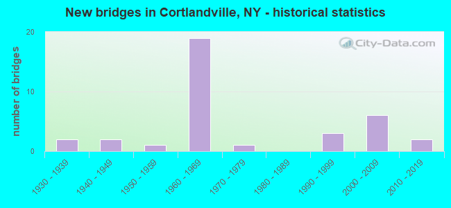
- New bridges - historical statistics
- 21930-1939
- 21940-1949
- 11950-1959
- 191960-1969
- 11970-1979
- 31990-1999
- 62000-2009
- 22010-2019
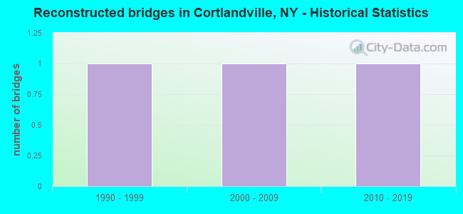
- Reconstructed bridges - Historical Statistics
- 11990-1999
- 12000-2009
- 12010-2019

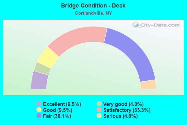
- Bridge Condition - Deck
- 9.5%Excellent
- 4.8%Very good
- 9.5%Good
- 33.3%Satisfactory
- 38.1%Fair
- 4.8%Serious
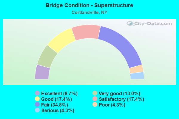
- Bridge Condition - Superstructure
- 8.7%Excellent
- 13.0%Very good
- 17.4%Good
- 17.4%Satisfactory
- 34.8%Fair
- 4.3%Poor
- 4.3%Serious
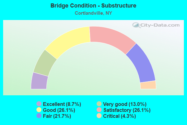
- Bridge Condition - Substructure
- 8.7%Excellent
- 13.0%Very good
- 26.1%Good
- 26.1%Satisfactory
- 21.7%Fair
- 4.3%Critical
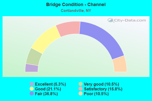
- Bridge Condition - Channel
- 5.3%Excellent
- 10.5%Very good
- 21.1%Good
- 15.8%Satisfactory
- 36.8%Fair
- 10.5%Poor
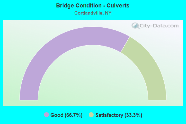
- Bridge Condition - Culverts
- 66.7%Good
- 33.3%Satisfactory
Find on map >> Show street view
Structure Number: 100835, Location: 4.1 Mi N Jct Rt 11 & 90 (Lat: 42.545683, Lng: -76.096431), Route carried "on" structure: US 11, Year Built: 2004, Status: Open, Structure Length: 0.94m (3.08ft), Average Daily Traffic: 1,724 (year 2020), Truck Traffic: 8%, Average Future Daily Traffic: 2,410 (year 2040), Design Load: HS 20, Features Intersected: Hoxie Gorge Creek
Minimum Vertical Clearance: 30+ m (98+ ft), Kilometerpoint: 17.007, Lanes on structure: 2, Base Highway Network: Yes, Owner: State Highway Agency, Approaching Roadway Width: 10.7m (35.1ft), Material/Design: Concrete, Design/Construction: Frame, Number Of Spans In Main Unit: 1, Length of Maximum Span: 9.2m (30.2ft), Curb-To-Curb Width: 10.8m (35.4ft), Out-to-Out Width: 11.8m (38.7ft)
Condition: Superstructure: Good, Substructure: Very good, Channel: Good, Operating Rating: 70.8 metric tons, Method Used To Determine Operating Rating: Load Factor (LF), Inventory Rating: 41.7 metric tons, Method Used To Determine Inventory Rating: Load Factor (LF), Structural Evaluation: Better than present minimum criteria, Deck Geometry: Equal to present minimum criteria, Waterway Adequacy: Equal to present minimum criteria, Approach Roadway Alignment: Equal to present desirable criteria, Length Of Structure Improvement: 0.94m (3.08ft), Designated Inspection Frequency: Every 24 months, Inspection Date: April 2020, Bridge Improvement Cost: $458,000, Roadway Improvement Cost: $268,000, Total Project Cost: $726,000 ( Estimate for 2021), Wearing Surface/Protective System: Wearing Surface: Bituminous
Find on map >> Show street view
Structure Number: 100836, Location: 0.5 MI S JCT RTS 11 + 41 (Lat: 42.585928, Lng: -76.129228), Route carried "on" structure: US 11, Year Built: 1956, Status: Open, Structure Length: 2.26m (7.41ft), Average Daily Traffic: 1,724 (year 2020), Truck Traffic: 8%, Average Future Daily Traffic: 2,133 (year 2040), Design Load: HS 20+Mod, Features Intersected: TROUT BROOK
Minimum Vertical Clearance: 30+ m (98+ ft), Kilometerpoint: 22.365, Lanes on structure: 2, Base Highway Network: Yes, Owner: State Highway Agency, Approaching Roadway Width: 13.4m (44.0ft), Material/Design: Concrete continuous, Design/Construction: Slab, Number Of Spans In Main Unit: 2, Length of Maximum Span: 10.9m (35.8ft), Curb-To-Curb Width: 12.2m (40.0ft), Out-to-Out Width: 13.1m (43.0ft)
Condition: Deck: Good, Superstructure: Good, Substructure: Satisfactory, Channel: Fair, Operating Rating: 80.4 metric tons, Method Used To Determine Operating Rating: Field evaluation and documented engineering judgment, Inventory Rating: 32.7 metric tons, Method Used To Determine Inventory Rating: Field evaluation and documented engineering judgment, Structural Evaluation: Equal to present minimum criteria, Deck Geometry: Better than present minimum criteria, Waterway Adequacy: Meets minimum limits, Approach Roadway Alignment: Equal to present desirable criteria, Length Of Structure Improvement: 2.25m (7.38ft), Designated Inspection Frequency: Every 24 months, Inspection Date: July 2021, Bridge Improvement Cost: $1,126,000, Roadway Improvement Cost: $660,000, Total Project Cost: $1,786,000 ( Estimate for 2021), Wearing Surface/Protective System: Wearing Surface: Bituminous, Membrane: Other
Find on map >> Show street view
Structure Number: 100837, Location: JCT RTE 11+TIOUGHNIOGA R (Lat: 42.598400, Lng: -76.158242), Route carried "on" structure: US 11, Year Built: 1933, Year Reconstructed: 1995, Status: Open, Structure Length: 5.97m (19.59ft), Average Daily Traffic: 8,195 (year 2018), Truck Traffic: 8%, Average Future Daily Traffic: 8,233 (year 2040), Design Load: HS 20, Features Intersected: TIOUGHNIOGA RIVER
Minimum Vertical Clearance: 4.47m (14.67ft), Kilometerpoint: 25.197, Lanes on structure: 2, Base Highway Network: Yes, Owner: State Highway Agency, Approaching Roadway Width: 11.6m (38.1ft), Skew: 3 degrees, Material/Design: Steel, Design/Construction: Truss - Thru, Number Of Spans In Main Unit: 1, Length of Maximum Span: 57.9m (190.0ft), Curb or Sidewalk Widths: Left: 1.7m (5.6ft), Right: 1.7m (5.6ft), Curb-To-Curb Width: 9.1m (29.9ft), Out-to-Out Width: 9.8m (32.2ft)
Condition: Deck: Satisfactory, Superstructure: Poor, Substructure: Fair, Channel: Fair, Operating Rating: 59.9 metric tons, Method Used To Determine Operating Rating: Load Factor (LF), Inventory Rating: 35.4 metric tons, Method Used To Determine Inventory Rating: Load Factor (LF), Structural Evaluation: Meets minimum limits, Deck Geometry: High priority of corrective action, Waterway Adequacy: Superior to present desirable criteria, Approach Roadway Alignment: Equal to present desirable criteria, Length Of Structure Improvement: 5.97m (19.59ft), Designated Inspection Frequency: Every 24 months, Critical Feature Inspection Frequency: Every 12 months, Inspection Date: December 2021, Critical Feature Inspection Date: December 2021, Bridge Improvement Cost: $4,626,000, Roadway Improvement Cost: $2,709,000, Total Project Cost: $7,334,000 ( Estimate for 2021), Deck Structure Type: Concrete Cast-file-Place, Wearing Surface/Protective System: Wearing Surface: Epoxy Overlay, Deck Protection: Epoxy Coated Reinforcing
Find on map >> Show street view
Structure Number: 100839, Location: 1.3 MI N JCT US11 & SH222 (Lat: 42.616994, Lng: -76.184572), Route carried "on" structure: US 11, Year Built: 1998, Status: Open, Structure Length: 7.65m (25.10ft), Average Daily Traffic: 5,160 (year 2020), Truck Traffic: 6%, Average Future Daily Traffic: 6,268 (year 2040), Design Load: HS 25 or greater, Features Intersected: NY SUSQUEHNNA & W
Minimum Vertical Clearance: 30+ m (98+ ft), Kilometerpoint: 29.429, Lanes on structure: 2, Base Highway Network: Yes, Owner: State Highway Agency, Approaching Roadway Width: 12.2m (40.0ft), Skew: 23 degrees, Material/Design: Steel continuous, Design/Construction: Stringer/Multi-beam, Number Of Spans In Main Unit: 3, Length of Maximum Span: 35.0m (114.8ft), Curb or Sidewalk Widths: Left: 1.6m (5.2ft), Right: 1.6m (5.2ft), Curb-To-Curb Width: 12.2m (40.0ft), Out-to-Out Width: 15.8m (51.8ft)
Condition: Deck: Satisfactory, Superstructure: Good, Substructure: Good, Operating Rating: 76.2 metric tons, Method Used To Determine Operating Rating: Load Factor (LF), Inventory Rating: 45.4 metric tons, Method Used To Determine Inventory Rating: Load Factor (LF), Structural Evaluation: Better than present minimum criteria, Deck Geometry: Somewhat better than minimum adequacy, Underclear: Somewhat better than minimum adequacy, Approach Roadway Alignment: Equal to present desirable criteria, Length Of Structure Improvement: 7.65m (25.10ft), Designated Inspection Frequency: Every 24 months, Inspection Date: November 2020, Bridge Improvement Cost: $2,567,000, Roadway Improvement Cost: $1,503,000, Total Project Cost: $4,070,000 ( Estimate for 2021), Deck Structure Type: Concrete Cast-file-Place, Wearing Surface/Protective System: Wearing Surface: Integral Concrete, Deck Protection: Epoxy Coated Reinforcing
Find on map >> Show street view
Structure Number: 1024911, Location: .1 MI NW OF EXIT 10 - I81 (Lat: 42.591181, Lng: -76.132603), Route carried "on" structure: Interstate 81, Year Built: 1966, Status: Open, Structure Length: 8.93m (29.30ft), Average Daily Traffic: 9,861 (year 2009), Truck Traffic: 31%, Design Load: HS 20, Features Intersected: RTE 41
Minimum Vertical Clearance: 30+ m (98+ ft), Kilometerpoint: 22.848, Lanes on structure: 3, Lanes under structure: 3, Base Highway Network: Yes, Owner: State Highway Agency, Approaching Roadway Width: 13.1m (43.0ft), Skew: 4 degrees, Material/Design: Steel, Design/Construction: Stringer/Multi-beam, Number Of Spans In Main Unit: 3, Length of Maximum Span: 34.7m (113.8ft), Curb-To-Curb Width: 12.8m (42.0ft), Out-to-Out Width: 14.4m (47.2ft)
Condition: Deck: Satisfactory, Superstructure: Fair, Substructure: Satisfactory, Operating Rating: 70.8 metric tons, Method Used To Determine Operating Rating: Load Factor (LF), Inventory Rating: 41.7 metric tons, Method Used To Determine Inventory Rating: Load Factor (LF), Structural Evaluation: Somewhat better than minimum adequacy, Deck Geometry: Meets minimum limits, Underclear: Meets minimum limits, Approach Roadway Alignment: Equal to present desirable criteria, Length Of Structure Improvement: 8.93m (29.30ft), Designated Inspection Frequency: Every 24 months, Inspection Date: September 2020, Bridge Improvement Cost: $2,611,000, Roadway Improvement Cost: $1,529,000, Total Project Cost: $4,140,000 ( Estimate for 2021), Deck Structure Type: Concrete Cast-file-Place, Wearing Surface/Protective System: Wearing Surface: Monolithic Concrete
Find on map >> Show street view
Structure Number: 1024912, Location: .1 MI NW OF EXIT 10 - I81 (Lat: 42.591106, Lng: -76.131689), Route carried "on" structure: Interstate 81, Year Built: 1966, Status: Open, Structure Length: 8.32m (27.30ft), Average Daily Traffic: 7,486 (year 2019), Truck Traffic: 27%, Average Future Daily Traffic: 10,798 (year 2040), Design Load: HS 20, Features Intersected: RTE 41
Minimum Vertical Clearance: 30+ m (98+ ft), Kilometerpoint: 22.848, Lanes on structure: 3, Lanes under structure: 3, Base Highway Network: Yes, Owner: State Highway Agency, Approaching Roadway Width: 14.3m (46.9ft), Skew: 5 degrees, Material/Design: Steel, Design/Construction: Stringer/Multi-beam, Number Of Spans In Main Unit: 3, Length of Maximum Span: 33.8m (110.9ft), Curb-To-Curb Width: 12.8m (42.0ft), Out-to-Out Width: 14.4m (47.2ft)
Condition: Deck: Satisfactory, Superstructure: Satisfactory, Substructure: Good, Operating Rating: 79.8 metric tons, Method Used To Determine Operating Rating: Load Factor (LF), Inventory Rating: 47.2 metric tons, Method Used To Determine Inventory Rating: Load Factor (LF), Structural Evaluation: Equal to present minimum criteria, Deck Geometry: Meets minimum limits, Underclear: High priority of corrective action, Approach Roadway Alignment: Equal to present desirable criteria, Length Of Structure Improvement: 8.32m (27.30ft), Designated Inspection Frequency: Every 24 months, Inspection Date: September 2020, Bridge Improvement Cost: $2,483,000, Roadway Improvement Cost: $1,454,000, Total Project Cost: $3,937,000 ( Estimate for 2021), Deck Structure Type: Concrete Cast-file-Place, Wearing Surface/Protective System: Wearing Surface: Monolithic Concrete
Find on map >> Show street view
Structure Number: 1031331, Location: 7.9 Mi N Jct Rts I-81 & 2 (Lat: 42.546786, Lng: -76.094294), Route carried "on" structure: Interstate 81, Year Built: 2006, Status: Open, Structure Length: 19.93m (65.39ft), Average Daily Traffic: 9,861 (year 2009), Truck Traffic: 30%, Design Load: HL 93, Features Intersected: Hoxie Gorge Rd, HOXIE GO
Minimum Vertical Clearance: 30+ m (98+ ft), Kilometerpoint: 16.846, Lanes on structure: 2, Lanes under structure: 2, Base Highway Network: Yes, Owner: State Highway Agency, Approaching Roadway Width: 11.6m (38.1ft), Material/Design: Steel, Design/Construction: Stringer/Multi-beam, Number Of Spans In Main Unit: 4, Length of Maximum Span: 56.1m (184.1ft), Curb-To-Curb Width: 11.6m (38.1ft), Out-to-Out Width: 12.5m (41.0ft)
Condition: Deck: Satisfactory, Superstructure: Very good, Substructure: Good, Channel: Good, Operating Rating: 55.4 metric tons, Method Used To Determine Operating Rating: Load and Resistance Factor Rating (LRFR) rating reported by rating factor(RF) method using HL-93 loadings, Inventory Rating: 42.4 metric tons, Method Used To Determine Inventory Rating: Load and Resistance Factor Rating (LRFR) rating reported by rating factor(RF) method using HL-93 loadings, Structural Evaluation: Better than present minimum criteria, Deck Geometry: Equal to present minimum criteria, Underclear: Superior to present desirable criteria, Waterway Adequacy: Equal to present minimum criteria, Approach Roadway Alignment: Equal to present desirable criteria, Length Of Structure Improvement: 19.93m (65.39ft), Designated Inspection Frequency: Every 24 months, Inspection Date: June 2020, Bridge Improvement Cost: $4,960,000, Roadway Improvement Cost: $2,905,000, Total Project Cost: $7,865,000 ( Estimate for 2021), Deck Structure Type: Concrete Cast-file-Place, Wearing Surface/Protective System: Wearing Surface: Monolithic Concrete, Deck Protection: Epoxy Coated Reinforcing
Find on map >> Show street view
Structure Number: 1031332, Location: 7.9 Mi N Jct Rts I81 & 22 (Lat: 42.546908, Lng: -76.093956), Route carried "on" structure: Interstate 81, Year Built: 2007, Status: Open, Structure Length: 19.78m (64.90ft), Average Daily Traffic: 7,486 (year 2019), Truck Traffic: 27%, Average Future Daily Traffic: 8,391 (year 2040), Design Load: HL 93, Features Intersected: Hoxie Gorge Rd, HOXIE GO
Minimum Vertical Clearance: 30+ m (98+ ft), Kilometerpoint: 16.846, Lanes on structure: 2, Lanes under structure: 2, Base Highway Network: Yes, Owner: State Highway Agency, Approaching Roadway Width: 11.6m (38.1ft), Material/Design: Steel continuous, Design/Construction: Stringer/Multi-beam, Number Of Spans In Main Unit: 4, Length of Maximum Span: 56.0m (183.7ft), Curb-To-Curb Width: 11.6m (38.1ft), Out-to-Out Width: 12.5m (41.0ft)
Condition: Deck: Good, Superstructure: Good, Substructure: Good, Channel: Very good, Operating Rating: 75.3 metric tons, Method Used To Determine Operating Rating: Load Factor (LF), Inventory Rating: 44.5 metric tons, Method Used To Determine Inventory Rating: Load Factor (LF), Structural Evaluation: Better than present minimum criteria, Deck Geometry: Equal to present minimum criteria, Underclear: Equal to present minimum criteria, Waterway Adequacy: Equal to present minimum criteria, Approach Roadway Alignment: Equal to present desirable criteria, Length Of Structure Improvement: 19.78m (64.90ft), Designated Inspection Frequency: Every 24 months, Inspection Date: June 2020, Bridge Improvement Cost: $4,953,000, Roadway Improvement Cost: $2,901,000, Total Project Cost: $7,854,000 ( Estimate for 2021), Deck Structure Type: Concrete Cast-file-Place, Wearing Surface/Protective System: Wearing Surface: Monolithic Concrete, Deck Protection: Epoxy Coated Reinforcing
Find on map >> Show street view
Structure Number: 1031341, Location: 8.3 MI N JCT RTS I-81+221 (Lat: 42.551514, Lng: -76.098200), Route carried "on" structure: Interstate 81, Year Built: 1966, Status: Open, Structure Length: 4.24m (13.91ft), Average Daily Traffic: 9,861 (year 2009), Truck Traffic: 30%, Design Load: HS 20+Mod, Features Intersected: SOUTH HILL ROAD
Minimum Vertical Clearance: 30+ m (98+ ft), Kilometerpoint: 17.570, Lanes on structure: 2, Lanes under structure: 2, Base Highway Network: Yes, Owner: State Highway Agency, Approaching Roadway Width: 10.7m (35.1ft), Material/Design: Steel, Design/Construction: Stringer/Multi-beam, Number Of Spans In Main Unit: 3, Length of Maximum Span: 14.0m (45.9ft), Curb or Sidewalk Widths: Left: 0.5m (1.6ft), Right: 0.5m (1.6ft), Curb-To-Curb Width: 9.1m (29.9ft), Out-to-Out Width: 10.7m (35.1ft)
Condition: Deck: Fair, Superstructure: Fair, Substructure: Fair, Operating Rating: 35.0 metric tons, Method Used To Determine Operating Rating: Load and Resistance Factor Rating (LRFR) rating reported by rating factor(RF) method using HL-93 loadings, Inventory Rating: 26.9 metric tons, Method Used To Determine Inventory Rating: Load and Resistance Factor Rating (LRFR) rating reported by rating factor(RF) method using HL-93 loadings, Structural Evaluation: Somewhat better than minimum adequacy, Deck Geometry: High priority of replacement, Underclear: Equal to present minimum criteria, Approach Roadway Alignment: Equal to present desirable criteria, Length Of Structure Improvement: 4.23m (13.88ft), Designated Inspection Frequency: Every 24 months, Inspection Date: May 2020, Bridge Improvement Cost: $952,000, Roadway Improvement Cost: $558,000, Total Project Cost: $1,510,000 ( Estimate for 2021), Deck Structure Type: Concrete Cast-file-Place, Wearing Surface/Protective System: Wearing Surface: Bituminous
Find on map >> Show street view
Structure Number: 1031342, Location: 8.3 MI N JCT RTS I-81+221 (Lat: 42.551814, Lng: -76.097867), Route carried "on" structure: Interstate 81, Year Built: 1966, Status: Open, Structure Length: 4.27m (14.01ft), Average Daily Traffic: 7,486 (year 2019), Truck Traffic: 27%, Average Future Daily Traffic: 8,391 (year 2040), Design Load: HS 20+Mod, Features Intersected: SOUTH HILL RD
Minimum Vertical Clearance: 30+ m (98+ ft), Kilometerpoint: 17.570, Lanes on structure: 2, Lanes under structure: 2, Base Highway Network: Yes, Owner: State Highway Agency, Approaching Roadway Width: 10.7m (35.1ft), Skew: 1 degrees, Material/Design: Steel, Design/Construction: Stringer/Multi-beam, Number Of Spans In Main Unit: 3, Length of Maximum Span: 14.3m (46.9ft), Curb-To-Curb Width: 9.1m (29.9ft), Out-to-Out Width: 10.7m (35.1ft)
Condition: Deck: Fair, Superstructure: Fair, Substructure: Fair, Operating Rating: 48.1 metric tons, Method Used To Determine Operating Rating: Load Factor (LF), Inventory Rating: 29.0 metric tons, Method Used To Determine Inventory Rating: Load Factor (LF), Structural Evaluation: Somewhat better than minimum adequacy, Deck Geometry: High priority of replacement, Underclear: High priority of corrective action, Approach Roadway Alignment: Equal to present desirable criteria, Length Of Structure Improvement: 4.26m (13.98ft), Designated Inspection Frequency: Every 24 months, Inspection Date: August 2020, Bridge Improvement Cost: $960,000, Roadway Improvement Cost: $562,000, Total Project Cost: $1,523,000 ( Estimate for 2021), Deck Structure Type: Concrete Cast-file-Place, Wearing Surface/Protective System: Wearing Surface: Bituminous
Find on map >> Show street view
Structure Number: 1031351, Location: 0.6 MI S JCT RTS I-81 +41 (Lat: 42.586389, Lng: -76.127631), Route carried "on" structure: Interstate 81, Year Built: 1966, Status: Open, Structure Length: 8.29m (27.20ft), Average Daily Traffic: 9,861 (year 2009), Truck Traffic: 30%, Design Load: HS 20+Mod, Features Intersected: RIDGE ROAD, TROUT BROOK
Minimum Vertical Clearance: 30+ m (98+ ft), Kilometerpoint: 22.220, Lanes on structure: 2, Lanes under structure: 2, Base Highway Network: Yes, Owner: State Highway Agency, Approaching Roadway Width: 15.8m (51.8ft), Material/Design: Steel, Design/Construction: Stringer/Multi-beam, Number Of Spans In Main Unit: 4, Length of Maximum Span: 27.7m (90.9ft), Curb-To-Curb Width: 12.8m (42.0ft), Out-to-Out Width: 14.4m (47.2ft)
Condition: Deck: Fair, Superstructure: Fair, Substructure: Satisfactory, Channel: Good, Operating Rating: 64.4 metric tons, Method Used To Determine Operating Rating: Load Factor (LF), Inventory Rating: 39.0 metric tons, Method Used To Determine Inventory Rating: Load Factor (LF), Structural Evaluation: Somewhat better than minimum adequacy, Deck Geometry: Equal to present desirable criteria, Underclear: Meets minimum limits, Waterway Adequacy: Superior to present desirable criteria, Approach Roadway Alignment: Equal to present desirable criteria, Length Of Structure Improvement: 8.29m (27.20ft), Designated Inspection Frequency: Every 24 months, Inspection Date: July 2021, Bridge Improvement Cost: $2,316,000, Roadway Improvement Cost: $1,356,000, Total Project Cost: $3,672,000 ( Estimate for 2021), Deck Structure Type: Concrete Cast-file-Place, Wearing Surface/Protective System: Wearing Surface: Monolithic Concrete
Find on map >> Show street view
Structure Number: 1031352, Location: 0.6 MI S JCT RTS I-81 +41 (Lat: 42.586553, Lng: -76.127111), Route carried "on" structure: Interstate 81, Year Built: 1966, Status: Open, Structure Length: 9.08m (29.79ft), Average Daily Traffic: 7,486 (year 2019), Truck Traffic: 27%, Average Future Daily Traffic: 10,798 (year 2040), Design Load: HS 20+Mod, Features Intersected: RIDGE ROAD, TROUT BROOK
Minimum Vertical Clearance: 30+ m (98+ ft), Kilometerpoint: 22.220, Lanes on structure: 2, Lanes under structure: 2, Base Highway Network: Yes, Owner: State Highway Agency, Approaching Roadway Width: 10.7m (35.1ft), Skew: 1 degrees, Material/Design: Steel, Design/Construction: Stringer/Multi-beam, Number Of Spans In Main Unit: 4, Length of Maximum Span: 27.7m (90.9ft), Curb-To-Curb Width: 9.1m (29.9ft), Out-to-Out Width: 10.7m (35.1ft)
Condition: Deck: Fair, Superstructure: Fair, Substructure: Satisfactory, Channel: Satisfactory, Operating Rating: 61.7 metric tons, Method Used To Determine Operating Rating: Load Factor (LF), Inventory Rating: 37.2 metric tons, Method Used To Determine Inventory Rating: Load Factor (LF), Structural Evaluation: Somewhat better than minimum adequacy, Deck Geometry: Meets minimum limits, Underclear: High priority of corrective action, Waterway Adequacy: Superior to present desirable criteria, Approach Roadway Alignment: Equal to present desirable criteria, Length Of Structure Improvement: 9.08m (29.79ft), Designated Inspection Frequency: Every 24 months, Inspection Date: July 2021, Bridge Improvement Cost: $1,910,000, Roadway Improvement Cost: $1,118,000, Total Project Cost: $3,028,000 ( Estimate for 2021), Deck Structure Type: Concrete Cast-file-Place, Wearing Surface/Protective System: Wearing Surface: Monolithic Concrete
Find on map >> Show street view
Structure Number: 103136, Location: 1.6 MI N JCT RTS I-81 +41 (Lat: 42.604072, Lng: -76.157072), Route carried "on" structure: County highway , Year Built: 1966, Status: Open, Structure Length: 12.47m (40.91ft), Average Daily Traffic: 716 (year 2020), Truck Traffic: 4%, Average Future Daily Traffic: 1,002 (year 2040), Design Load: HS 20, Features Intersected: 81I 81I32021159, 81I 81I, Facility Carried by Structure: EAST RIVER ROAD
Minimum Vertical Clearance: 30+ m (98+ ft), Kilometerpoint: 0.644, Lanes on structure: 2, Lanes under structure: 4, Owner: State Highway Agency, Approaching Roadway Width: 7.6m (24.9ft), Skew: 4 degrees, Material/Design: Steel, Design/Construction: Stringer/Multi-beam, Number Of Spans In Main Unit: 6, Length of Maximum Span: 23.7m (77.8ft), Curb-To-Curb Width: 9.1m (29.9ft), Out-to-Out Width: 10.7m (35.1ft)
Condition: Deck: Satisfactory, Superstructure: Satisfactory, Substructure: Good, Operating Rating: 49.0 metric tons, Method Used To Determine Operating Rating: Load Factor (LF), Inventory Rating: 29.0 metric tons, Method Used To Determine Inventory Rating: Load Factor (LF), Structural Evaluation: Equal to present minimum criteria, Deck Geometry: Equal to present minimum criteria, Underclear: High priority of corrective action, Approach Roadway Alignment: Equal to present desirable criteria, Length Of Structure Improvement: 12.46m (40.88ft), Designated Inspection Frequency: Every 24 months, Inspection Date: September 2021, Bridge Improvement Cost: $2,637,000, Roadway Improvement Cost: $1,544,000, Total Project Cost: $4,180,000 ( Estimate for 2021), Deck Structure Type: Concrete Cast-file-Place, Wearing Surface/Protective System: Wearing Surface: Monolithic Concrete
Find on map >> Show street view
Structure Number: 1031371, Location: JCT RTE 81I+TIOUGHNIOGA R (Lat: 42.606628, Lng: -76.158103), Route carried "on" structure: Interstate 81, Year Built: 1966, Year Reconstructed: 2009, Status: Open, Structure Length: 12.41m (40.72ft), Average Daily Traffic: 9,431 (year 2008), Truck Traffic: 31%, Design Load: HS 20, Features Intersected: TIOUGHNIOGA RIVER
Minimum Vertical Clearance: 30+ m (98+ ft), Kilometerpoint: 0.000, Lanes on structure: 2, Base Highway Network: Yes, Owner: State Highway Agency, Approaching Roadway Width: 9.1m (29.9ft), Skew: 5 degrees, Material/Design: Steel, Design/Construction: Stringer/Multi-beam, Number Of Spans In Main Unit: 5, Length of Maximum Span: 23.7m (77.8ft), Curb-To-Curb Width: 9.1m (29.9ft), Out-to-Out Width: 10.7m (35.1ft)
Condition: Deck: Fair, Superstructure: Satisfactory, Substructure: Satisfactory, Channel: Fair, Operating Rating: 38.1 metric tons, Method Used To Determine Operating Rating: Load Factor (LF), Inventory Rating: 22.7 metric tons, Method Used To Determine Inventory Rating: Load Factor (LF), Structural Evaluation: Somewhat better than minimum adequacy, Deck Geometry: Meets minimum limits, Waterway Adequacy: Equal to present minimum criteria, Approach Roadway Alignment: Equal to present minimum criteria, Length Of Structure Improvement: 12.40m (40.68ft), Designated Inspection Frequency: Every 24 months, Inspection Date: September 2021, Bridge Improvement Cost: $2,771,000, Roadway Improvement Cost: $1,623,000, Total Project Cost: $4,394,000 ( Estimate for 2021), Deck Structure Type: Concrete Cast-file-Place, Wearing Surface/Protective System: Wearing Surface: Bituminous, Membrane: Other
Find on map >> Show street view
Structure Number: 1031372, Location: JCT RTE 81I+TIOUGHNIOGA R (Lat: 42.607225, Lng: -76.157956), Route carried "on" structure: Interstate 81, Year Built: 1966, Status: Open, Structure Length: 12.22m (40.09ft), Average Daily Traffic: 7,217 (year 2019), Truck Traffic: 26%, Average Future Daily Traffic: 10,410 (year 2040), Design Load: HS 20, Features Intersected: TIOUGHNIOGA RIVER
Minimum Vertical Clearance: 30+ m (98+ ft), Kilometerpoint: 25.841, Lanes on structure: 2, Base Highway Network: Yes, Owner: State Highway Agency, Approaching Roadway Width: 9.1m (29.9ft), Skew: 4 degrees, Material/Design: Steel, Design/Construction: Stringer/Multi-beam, Number Of Spans In Main Unit: 5, Length of Maximum Span: 23.4m (76.8ft), Curb-To-Curb Width: 9.1m (29.9ft), Out-to-Out Width: 10.7m (35.1ft)
Condition: Deck: Fair, Superstructure: Satisfactory, Substructure: Good, Channel: Fair, Operating Rating: 42.6 metric tons, Method Used To Determine Operating Rating: Load Factor (LF), Inventory Rating: 25.4 metric tons, Method Used To Determine Inventory Rating: Load Factor (LF), Structural Evaluation: Equal to present minimum criteria, Deck Geometry: Meets minimum limits, Waterway Adequacy: Equal to present minimum criteria, Approach Roadway Alignment: Equal to present minimum criteria, Length Of Structure Improvement: 12.22m (40.09ft), Designated Inspection Frequency: Every 24 months, Inspection Date: September 2021, Bridge Improvement Cost: $2,593,000, Roadway Improvement Cost: $1,518,000, Total Project Cost: $4,111,000 ( Estimate for 2021), Deck Structure Type: Concrete Cast-file-Place, Wearing Surface/Protective System: Wearing Surface: Bituminous, Membrane: Other
Find on map >> Show street view
Structure Number: 103139, Location: 1.9 MI N JCT I81 & SH 13 (Lat: 42.625369, Lng: -76.177478), Route carried "on" structure: Ramp Interstate , Year Built: 1966, Status: Open, Structure Length: 10.64m (34.91ft), Average Daily Traffic: 2,527 (year 2017), Truck Traffic: 10%, Average Future Daily Traffic: 2,832 (year 2040), Design Load: HS 20, Features Intersected: 81I 81I32023008 SB, RTE, Facility Carried by Structure: RAMP TO HOMER
Minimum Vertical Clearance: 30+ m (98+ ft), Kilometerpoint: 0.225, Lanes on structure: 2, Lanes under structure: 4, Owner: State Highway Agency, Approaching Roadway Width: 12.8m (42.0ft), Skew: 23 degrees, Material/Design: Steel, Design/Construction: Stringer/Multi-beam, Number Of Spans In Main Unit: 6, Length of Maximum Span: 23.7m (77.8ft), Curb-To-Curb Width: 11.6m (38.1ft), Out-to-Out Width: 13.2m (43.3ft)
Condition: Deck: Satisfactory, Superstructure: Fair, Substructure: Satisfactory, Operating Rating: 49.9 metric tons, Method Used To Determine Operating Rating: Load Factor (LF), Inventory Rating: 29.9 metric tons, Method Used To Determine Inventory Rating: Load Factor (LF), Structural Evaluation: Somewhat better than minimum adequacy, Deck Geometry: Superior to present desirable criteria, Underclear: High priority of corrective action, Approach Roadway Alignment: Equal to present desirable criteria, Length Of Structure Improvement: 10.63m (34.88ft), Designated Inspection Frequency: Every 24 months, Inspection Date: May 2021, Bridge Improvement Cost: $2,718,000, Roadway Improvement Cost: $1,591,000, Total Project Cost: $4,309,000 ( Estimate for 2021), Deck Structure Type: Concrete Cast-file-Place, Wearing Surface/Protective System: Wearing Surface: Monolithic Concrete
Find on map >> Show street view
Structure Number: 104441, Location: 0.1 MI NE JCT RTS 281+222 (Lat: 42.599414, Lng: -76.203631), Route carried "on" structure: State highway 281, Year Built: 2017, Status: Open, Structure Length: 0.91m (2.99ft), Average Daily Traffic: 15,939 (year 2020), Truck Traffic: 8%, Average Future Daily Traffic: 16,013 (year 2040), Design Load: HS 20, Features Intersected: DRY CREEK
Minimum Vertical Clearance: 30+ m (98+ ft), Kilometerpoint: 2.767, Lanes on structure: 5, Base Highway Network: Yes, Owner: State Highway Agency, Approaching Roadway Width: 23.4m (76.8ft), Skew: 21 degrees, Material/Design: Concrete, Design/Construction: Frame, Number Of Spans In Main Unit: 1, Length of Maximum Span: 8.8m (28.9ft), Curb or Sidewalk Widths: Left: 2.7m (8.9ft), Right: 2.7m (8.9ft), Curb-To-Curb Width: 23.4m (76.8ft), Out-to-Out Width: 32.6m (107.0ft)
Condition: Superstructure: Excellent, Substructure: Excellent, Channel: Satisfactory, Operating Rating: 78.8 metric tons, Method Used To Determine Operating Rating: Field evaluation and documented engineering judgment, Inventory Rating: 32.7 metric tons, Method Used To Determine Inventory Rating: Field evaluation and documented engineering judgment, Structural Evaluation: Superior to present desirable criteria, Deck Geometry: Better than present minimum criteria, Waterway Adequacy: Somewhat better than minimum adequacy, Approach Roadway Alignment: Equal to present desirable criteria, Length Of Structure Improvement: 0.91m (2.99ft), Designated Inspection Frequency: Every 24 months, Inspection Date: July 2021, Bridge Improvement Cost: $977,000, Roadway Improvement Cost: $572,000, Total Project Cost: $1,549,000 ( Estimate for 2021)
Find on map >> Show street view
Structure Number: 109376, Location: 3.6 MI N VIRGIL ON RTE 90 (Lat: 42.560728, Lng: -76.190531), Route carried "on" structure: State highway 215, Year Built: 1971, Status: Open, Structure Length: 0.73m (2.40ft), Average Daily Traffic: 1,371 (year 2020), Truck Traffic: 4%, Average Future Daily Traffic: 1,919 (year 2040), Design Load: HS 20, Features Intersected: OTTER CREEK
Minimum Vertical Clearance: 30+ m (98+ ft), Kilometerpoint: 5.825, Lanes on structure: 2, Base Highway Network: Yes, Owner: State Highway Agency, Approaching Roadway Width: 14.6m (47.9ft), Material/Design: Steel, Design/Construction: Culvert, Number Of Spans In Main Unit: 2, Length of Maximum Span: 3.3m (10.8ft)
Condition: Channel: Fair, Culverts: Satisfactory, Operating Rating: 74.7 metric tons, Method Used To Determine Operating Rating: Field evaluation and documented engineering judgment, Inventory Rating: 29.4 metric tons, Method Used To Determine Inventory Rating: Field evaluation and documented engineering judgment, Structural Evaluation: Equal to present minimum criteria, Waterway Adequacy: Somewhat better than minimum adequacy, Approach Roadway Alignment: Equal to present desirable criteria, Length Of Structure Improvement: 0.73m (2.40ft), Designated Inspection Frequency: Every 24 months, Inspection Date: September 2021, Bridge Improvement Cost: $248,000, Roadway Improvement Cost: $145,000, Total Project Cost: $393,000 ( Estimate for 2021)
Find on map >> Show street view
Structure Number: 220722, Location: 3.5 MI S OF MCGRAW (Lat: 42.546983, Lng: -76.093583), Route carried "on" structure: Other road , Year Built: 1940, Status: Open, Structure Length: 1.28m (4.20ft), Average Daily Traffic: 289 (year 2017), Truck Traffic: 8%, Average Future Daily Traffic: 405 (year 2037), Features Intersected: HOXIE GORGE CREEK, Facility Carried by Structure: HOXIE GORGE ROAD
Minimum Vertical Clearance: 30+ m (98+ ft), Kilometerpoint: 0.306, Lanes on structure: 2, Owner: Town or Township Highway Agency, Approaching Roadway Width: 4.6m (15.1ft), Material/Design: Concrete continuous, Design/Construction: Slab, Number Of Spans In Main Unit: 2, Length of Maximum Span: 5.7m (18.7ft), Curb-To-Curb Width: 6.6m (21.7ft), Out-to-Out Width: 7.6m (24.9ft)
Condition: Deck: Fair, Superstructure: Fair, Substructure: Critical, Channel: Poor, Operating Rating: 73.5 metric tons, Method Used To Determine Operating Rating: Field evaluation and documented engineering judgment, Inventory Rating: 29.4 metric tons, Method Used To Determine Inventory Rating: Field evaluation and documented engineering judgment, Structural Evaluation: High priority of replacement, Deck Geometry: Meets minimum limits, Waterway Adequacy: High priority of corrective action, Approach Roadway Alignment: Better than present minimum criteria, Length Of Structure Improvement: 1.28m (4.20ft), Designated Inspection Frequency: Every 24 months, Inspection Date: April 2021, Bridge Improvement Cost: $321,000, Roadway Improvement Cost: $188,000, Total Project Cost: $509,000 ( Estimate for 2021), Wearing Surface/Protective System: Wearing Surface: Bituminous
Find on map >> Show street view
Structure Number: 220723, Location: 3.5 MI S OF MCGRAW (Lat: 42.547347, Lng: -76.091689), Route carried "on" structure: Other road , Year Built: 1940, Status: Open, Structure Length: 1.40m (4.59ft), Average Daily Traffic: 289 (year 2017), Truck Traffic: 8%, Average Future Daily Traffic: 405 (year 2037), Features Intersected: HOXIE GORGE, Facility Carried by Structure: HOXIE GORGE ROAD
Minimum Vertical Clearance: 30+ m (98+ ft), Kilometerpoint: 0.451, Lanes on structure: 2, Owner: Town or Township Highway Agency, Approaching Roadway Width: 4.6m (15.1ft), Skew: 4 degrees, Material/Design: Concrete continuous, Design/Construction: Slab, Number Of Spans In Main Unit: 2, Length of Maximum Span: 5.7m (18.7ft), Curb-To-Curb Width: 6.8m (22.3ft), Out-to-Out Width: 8.0m (26.2ft)
Condition: Deck: Fair, Superstructure: Fair, Substructure: Fair, Channel: Poor, Operating Rating: 73.9 metric tons, Method Used To Determine Operating Rating: Field evaluation and documented engineering judgment, Inventory Rating: 32.7 metric tons, Method Used To Determine Inventory Rating: Field evaluation and documented engineering judgment, Structural Evaluation: Somewhat better than minimum adequacy, Deck Geometry: Meets minimum limits, Waterway Adequacy: Meets minimum limits, Approach Roadway Alignment: Better than present minimum criteria, Length Of Structure Improvement: 1.40m (4.59ft), Designated Inspection Frequency: Every 24 months, Inspection Date: April 2021, Bridge Improvement Cost: $399,000, Roadway Improvement Cost: $233,000, Total Project Cost: $632,000 ( Estimate for 2021), Wearing Surface/Protective System: Wearing Surface: Bituminous
Find on map >> Show street view
Structure Number: 331186, Location: 1 MI NW JCT SH222 & SH281 (Lat: 42.604389, Lng: -76.214931), Route carried "on" structure: County highway , Year Built: 2018, Status: Open, Structure Length: 1.83m (6.00ft), Average Daily Traffic: 1,600 (year 2020), Truck Traffic: 6%, Average Future Daily Traffic: 1,979 (year 2040), Features Intersected: BLUE CREEK, Facility Carried by Structure: KINNEY GULF ROAD
Minimum Vertical Clearance: 30+ m (98+ ft), Kilometerpoint: 1.094, Lanes on structure: 2, Owner: County Highway Agency, Approaching Roadway Width: 7.6m (24.9ft), Skew: 4 degrees, Material/Design: Steel, Design/Construction: Stringer/Multi-beam, Number Of Spans In Main Unit: 1, Length of Maximum Span: 17.4m (57.1ft), Curb-To-Curb Width: 9.1m (29.9ft), Out-to-Out Width: 10.1m (33.1ft)
Condition: Deck: Excellent, Superstructure: Very good, Substructure: Excellent, Channel: Excellent, Operating Rating: 84.9 metric tons, Method Used To Determine Operating Rating: Field evaluation and documented engineering judgment, Inventory Rating: 40.8 metric tons, Method Used To Determine Inventory Rating: Field evaluation and documented engineering judgment, Structural Evaluation: Equal to present desirable criteria, Deck Geometry: Somewhat better than minimum adequacy, Waterway Adequacy: Meets minimum limits, Approach Roadway Alignment: Equal to present minimum criteria, Length Of Structure Improvement: 1.82m (5.97ft), Designated Inspection Frequency: Every 24 months, Inspection Date: October 2020, Bridge Improvement Cost: $335,000, Roadway Improvement Cost: $196,000, Total Project Cost: $532,000 ( Estimate for 2021), Deck Structure Type: Concrete Cast-file-Place, Wearing Surface/Protective System: Wearing Surface: Integral Concrete, Deck Protection: Epoxy Coated Reinforcing
Find on map >> Show street view
Structure Number: 331199, Location: 1.4 MILES SE OF MCGRAW (Lat: 42.585219, Lng: -76.070667), Route carried "on" structure: County highway , Year Built: 2005, Status: Open, Structure Length: 0.98m (3.22ft), Average Daily Traffic: 837 (year 2020), Truck Traffic: 7%, Average Future Daily Traffic: 1,035 (year 2040), Design Load: HS 25 or greater, Features Intersected: SMITH BROOK, Facility Carried by Structure: COUNTY ROAD 116
Minimum Vertical Clearance: 30+ m (98+ ft), Kilometerpoint: 17.747, Lanes on structure: 2, Owner: County Highway Agency, Approaching Roadway Width: 9.4m (30.8ft), Skew: 3 degrees, Material/Design: Concrete, Design/Construction: Culvert, Number Of Spans In Main Unit: 1, Length of Maximum Span: 9.6m (31.5ft)
Condition: Channel: Fair, Culverts: Good, Operating Rating: 97.1 metric tons, Method Used To Determine Operating Rating: Load Factor (LF), Inventory Rating: 58.1 metric tons, Method Used To Determine Inventory Rating: Load Factor (LF), Structural Evaluation: Better than present minimum criteria, Waterway Adequacy: Meets minimum limits, Approach Roadway Alignment: Equal to present desirable criteria, Length Of Structure Improvement: 0.97m (3.18ft), Designated Inspection Frequency: Every 24 months, Inspection Date: October 2021, Bridge Improvement Cost: $306,000, Roadway Improvement Cost: $179,000, Total Project Cost: $485,000 ( Estimate for 2021)
Find on map >> Show street view
Structure Number: 33123, Location: 1.5 MI NW OF CORTLAND (Lat: 42.626603, Lng: -76.147853), Route carried "on" structure: County highway , Year Built: 1937, Status: Open, Structure Length: 5.46m (17.91ft), Average Daily Traffic: 828 (year 2018), Truck Traffic: 6%, Average Future Daily Traffic: 1,159 (year 2038), Design Load: H 20, Features Intersected: EAST BRANCH TIOUGHNIOGA, Facility Carried by Structure: Loring Crossing Ro
Minimum Vertical Clearance: 30+ m (98+ ft), Kilometerpoint: 0.386, Lanes on structure: 2, Owner: County Highway Agency, Approaching Roadway Width: 6.7m (22.0ft), Skew: 1 degrees, Material/Design: Concrete continuous, Design/Construction: Frame, Number Of Spans In Main Unit: 2, Length of Maximum Span: 26.2m (86.0ft), Curb or Sidewalk Widths: Left: 0.0m, Right: 1.2m (3.9ft), Curb-To-Curb Width: 7.3m (24.0ft), Out-to-Out Width: 9.7m (31.8ft)
Condition: Deck: Serious, Superstructure: Serious, Substructure: Fair, Channel: Satisfactory, Operating Rating: 61.7 metric tons, Method Used To Determine Operating Rating: Field evaluation and documented engineering judgment, Inventory Rating: 15.1 metric tons, Method Used To Determine Inventory Rating: Field evaluation and documented engineering judgment, Structural Evaluation: High priority of corrective action, Deck Geometry: Meets minimum limits, Waterway Adequacy: Better than present minimum criteria, Approach Roadway Alignment: Equal to present desirable criteria, Length Of Structure Improvement: 5.45m (17.88ft), Designated Inspection Frequency: Every 12 months, Inspection Date: May 2021, Bridge Improvement Cost: $1,270,000, Roadway Improvement Cost: $744,000, Total Project Cost: $2,014,000 ( Estimate for 2021), Wearing Surface/Protective System: Wearing Surface: Bituminous, Membrane: Other
Find on map >> Show street view
Structure Number: 331252, Location: 0.2 MI E OF BLODGETT MILL (Lat: 42.568231, Lng: -76.121122), Route carried "on" structure: County highway , Year Built: 1965, Year Reconstructed: 2019, Status: Open, Structure Length: 5.94m (19.49ft), Average Daily Traffic: 865 (year 2018), Truck Traffic: 4%, Average Future Daily Traffic: 1,211 (year 2038), Design Load: HS 20+Mod, Features Intersected: TIOUGHNIOGA RIVER, Facility Carried by Structure: BLODGETT MLLS W R
Minimum Vertical Clearance: 30+ m (98+ ft), Kilometerpoint: 0.354, Lanes on structure: 2, Owner: County Highway Agency, Approaching Roadway Width: 7.0m (23.0ft), Material/Design: Steel, Design/Construction: Stringer/Multi-beam, Number Of Spans In Main Unit: 2, Length of Maximum Span: 29.0m (95.1ft), Curb-To-Curb Width: 7.9m (25.9ft), Out-to-Out Width: 8.9m (29.2ft)
Condition: Deck: Excellent, Superstructure: Excellent, Substructure: Very good, Channel: Very good, Operating Rating: 86.2 metric tons, Method Used To Determine Operating Rating: Load Factor (LF), Inventory Rating: 51.7 metric tons, Method Used To Determine Inventory Rating: Load Factor (LF), Structural Evaluation: Equal to present desirable criteria, Deck Geometry: Somewhat better than minimum adequacy, Waterway Adequacy: Better than present minimum criteria, Approach Roadway Alignment: Equal to present desirable criteria, Length Of Structure Improvement: 5.94m (19.49ft), Designated Inspection Frequency: Every 24 months, Inspection Date: November 2021, Bridge Improvement Cost: $1,271,000, Roadway Improvement Cost: $744,000, Total Project Cost: $2,015,000 ( Estimate for 2021), Deck Structure Type: Concrete Cast-file-Place, Wearing Surface/Protective System: Wearing Surface: Integral Concrete, Deck Protection: Epoxy Coated Reinforcing
Find on map >> Show street view
Structure Number: 336774, Location: 1.0 MI W OF CORTLAND (Lat: 42.613617, Lng: -76.214128), Route carried "on" structure: Other road , Year Built: 1996, Status: Open, Structure Length: 0.85m (2.79ft), Average Daily Traffic: 373 (year 2019), Truck Traffic: 4%, Average Future Daily Traffic: 522 (year 2039), Features Intersected: BLUE CREEK, Facility Carried by Structure: BLUE CREEK ROAD
Minimum Vertical Clearance: 30+ m (98+ ft), Kilometerpoint: 0.853, Lanes on structure: 2, Owner: Town or Township Highway Agency, Approaching Roadway Width: 6.4m (21.0ft), Skew: 1 degrees, Material/Design: Aluminum, Iron, Design/Construction: Culvert, Number Of Spans In Main Unit: 1, Length of Maximum Span: 6.7m (22.0ft), Curb-To-Curb Width: 8.1m (26.6ft), Out-to-Out Width: 22.0m (72.2ft)
Condition: Channel: Fair, Culverts: Good, Operating Rating: 77.3 metric tons, Method Used To Determine Operating Rating: Field evaluation and documented engineering judgment, Inventory Rating: 40.8 metric tons, Method Used To Determine Inventory Rating: Field evaluation and documented engineering judgment, Structural Evaluation: Better than present minimum criteria, Deck Geometry: Somewhat better than minimum adequacy, Waterway Adequacy: Meets minimum limits, Approach Roadway Alignment: Equal to present desirable criteria, Length Of Structure Improvement: 0.85m (2.79ft), Designated Inspection Frequency: Every 24 months, Inspection Date: April 2021, Bridge Improvement Cost: $436,000, Roadway Improvement Cost: $255,000, Total Project Cost: $691,000 ( Estimate for 2021), Wearing Surface/Protective System: Wearing Surface: Bituminous
Find on map >> Show street view
Structure Number: 336961, Location: W VILLAGE LINE MCGRAW (Lat: 42.591867, Lng: -76.107950), Route carried "on" structure: County highway , Year Built: 1999, Status: Open, Structure Length: 3.35m (10.99ft), Average Daily Traffic: 671 (year 2020), Truck Traffic: 3%, Average Future Daily Traffic: 939 (year 2040), Design Load: HS 25 or greater, Features Intersected: TROUT BROOK, Facility Carried by Structure: ELM STREET
Minimum Vertical Clearance: 30+ m (98+ ft), Kilometerpoint: 0.161, Lanes on structure: 2, Owner: County Highway Agency, Approaching Roadway Width: 9.1m (29.9ft), Material/Design: Steel, Design/Construction: Stringer/Multi-beam, Number Of Spans In Main Unit: 1, Length of Maximum Span: 32.9m (107.9ft), Curb-To-Curb Width: 9.1m (29.9ft), Out-to-Out Width: 9.8m (32.2ft)
Condition: Deck: Very good, Superstructure: Very good, Substructure: Very good, Channel: Good, Operating Rating: 73.5 metric tons, Method Used To Determine Operating Rating: Load Factor (LF), Inventory Rating: 44.5 metric tons, Method Used To Determine Inventory Rating: Load Factor (LF), Structural Evaluation: Equal to present desirable criteria, Deck Geometry: Equal to present minimum criteria, Waterway Adequacy: Equal to present minimum criteria, Approach Roadway Alignment: Better than present minimum criteria, Length Of Structure Improvement: 3.35m (10.99ft), Designated Inspection Frequency: Every 24 months, Inspection Date: October 2021, Bridge Improvement Cost: $699,000, Roadway Improvement Cost: $409,000, Total Project Cost: $1,108,000 ( Estimate for 2021), Deck Structure Type: Concrete Cast-file-Place, Wearing Surface/Protective System: Wearing Surface: Bituminous, Deck Protection: Epoxy Coated Reinforcing
Find on map >> Show street view
Structure Number: 1024911, Location: .1 MI NW OF EXIT 10 - I81 (Lat: 42.591181, Lng: -76.132603), Route carried "under" structure: State highway 41, Year Built: 1966, Structure Length: 0. m, Average Daily Traffic: 9,340 (year 1998), Features Intersected: RTE 41, Facility Carried by Structure: RTE I81
Minimum Vertical Clearance: 6.14m (20.14ft), Kilometerpoint: 36.235, Lanes on structure: 3, Lanes under structure: 3, Material/Design: Steel, Design/Construction: Stringer/Multi-beam, Length of Maximum Span: 34.7m (113.8ft)
Find on map >> Show street view
Structure Number: 1024912, Location: .1 MI NW OF EXIT 10 - I81 (Lat: 42.591106, Lng: -76.131689), Route carried "under" structure: State highway 41, Year Built: 1966, Structure Length: 0. m, Average Daily Traffic: 9,340 (year 1998), Features Intersected: RTE 41, Facility Carried by Structure: RTE I81
Minimum Vertical Clearance: 6.14m (20.14ft), Kilometerpoint: 36.235, Lanes on structure: 3, Lanes under structure: 3, Material/Design: Steel, Design/Construction: Stringer/Multi-beam, Length of Maximum Span: 33.8m (110.9ft)
Find on map >> Show street view
Structure Number: 1031331, Location: 7.9 Mi N Jct Rts I-81 & 2 (Lat: 42.546786, Lng: -76.094294), Route carried "under" structure: Other road , Year Built: 2006, Structure Length: 0. m, Average Daily Traffic: 145 (year 2017), Truck Traffic: 8%, Features Intersected: Hoxie Gorge Rd, HOXIE GO, Facility Carried by Structure: RTE I81
Minimum Vertical Clearance: 30+ m (98+ ft), Kilometerpoint: 0.000, Lanes on structure: 2, Lanes under structure: 2, Material/Design: Steel, Design/Construction: Stringer/Multi-beam, Length of Maximum Span: 56.1m (184.1ft)
Find on map >> Show street view
Structure Number: 1031332, Location: 7.9 Mi N Jct Rts I81 & 22 (Lat: 42.546908, Lng: -76.093956), Route carried "under" structure: Other road , Year Built: 2007, Structure Length: 0. m, Average Daily Traffic: 145 (year 2017), Truck Traffic: 8%, Features Intersected: Hoxie Gorge Rd, HOXIE GO, Facility Carried by Structure: RTE I81
Minimum Vertical Clearance: 30+ m (98+ ft), Kilometerpoint: 0.225, Lanes on structure: 2, Lanes under structure: 2, Material/Design: Steel continuous, Design/Construction: Stringer/Multi-beam, Length of Maximum Span: 56.0m (183.7ft)
Find on map >> Show street view
Structure Number: 1031341, Location: 8.3 MI N JCT RTS I-81+221 (Lat: 42.551514, Lng: -76.098200), Route carried "under" structure: Other road , Year Built: 1966, Structure Length: 0. m, Features Intersected: SOUTH HILL ROAD, Facility Carried by Structure: RTE I81
Minimum Vertical Clearance: 5.28m (17.32ft), Kilometerpoint: 0.000, Lanes on structure: 2, Lanes under structure: 2, Material/Design: Steel, Design/Construction: Stringer/Multi-beam, Length of Maximum Span: 14.0m (45.9ft)
Find on map >> Show street view
Structure Number: 1031342, Location: 8.3 MI N JCT RTS I-81+221 (Lat: 42.551814, Lng: -76.097867), Route carried "under" structure: Other road , Year Built: 1966, Structure Length: 0. m, Features Intersected: SOUTH HILL RD, Facility Carried by Structure: RTE I81
Minimum Vertical Clearance: 5.18m (16.99ft), Kilometerpoint: 0.338, Lanes on structure: 2, Lanes under structure: 2, Material/Design: Steel, Design/Construction: Stringer/Multi-beam, Length of Maximum Span: 14.3m (46.9ft)
Find on map >> Show street view
Structure Number: 1031351, Location: 0.6 MI S JCT RTS I-81 +41 (Lat: 42.586389, Lng: -76.127631), Route carried "under" structure: ServiceOther road , Year Built: 1966, Structure Length: 0. m, Features Intersected: RIDGE ROAD, TROUT BROOK, Facility Carried by Structure: RTE I81
Minimum Vertical Clearance: 9.30m (30.51ft), Kilometerpoint: 0.129, Lanes on structure: 2, Lanes under structure: 2, Material/Design: Steel, Design/Construction: Stringer/Multi-beam, Length of Maximum Span: 27.7m (90.9ft)
Find on map >> Show street view
Structure Number: 1031352, Location: 0.6 MI S JCT RTS I-81 +41 (Lat: 42.586553, Lng: -76.127111), Route carried "under" structure: ServiceOther road , Year Built: 1966, Structure Length: 0. m, Features Intersected: RIDGE ROAD, TROUT BROOK, Facility Carried by Structure: RTE I81
Minimum Vertical Clearance: 9.45m (31.00ft), Kilometerpoint: 0.000, Lanes on structure: 2, Lanes under structure: 2, Material/Design: Steel, Design/Construction: Stringer/Multi-beam, Length of Maximum Span: 27.7m (90.9ft)
Find on map >> Show street view
Structure Number: 103136, Location: 1.6 MI N JCT RTS I-81 +41 (Lat: 42.604072, Lng: -76.157072), Route carried "under" structure: Interstate , Year Built: 1966, Structure Length: 0. m, Average Daily Traffic: 10,200 (year 1972), Features Intersected: 81I 81I32021159, 81I 81I, Facility Carried by Structure: EAST RIVER ROAD
Minimum Vertical Clearance: 5.44m (17.85ft), Kilometerpoint: 25.615, Lanes on structure: 2, Lanes under structure: 2, Material/Design: Steel, Design/Construction: Stringer/Multi-beam, Length of Maximum Span: 23.7m (77.8ft)
Find on map >> Show street view
Structure Number: 103139, Location: 1.9 MI N JCT I81 & SH 13 (Lat: 42.625369, Lng: -76.177478), Route carried "under" structure: Interstate 81, Year Built: 1966, Structure Length: 0. m, Average Daily Traffic: 22,061 (year 1999), Features Intersected: 81I 81I32023008 SB, RTE, Facility Carried by Structure: RAMP TO HOMER
Minimum Vertical Clearance: 5.36m (17.59ft), Kilometerpoint: 1.352, Lanes on structure: 2, Lanes under structure: 2, Material/Design: Steel, Design/Construction: Stringer/Multi-beam, Length of Maximum Span: 23.7m (77.8ft)