Bridge Statistics for Coventry, Rhode Island (RI)
Condition, Traffic, Stress, Structural Evaluation, Project Costs
- National Bridge Inventory (NBI) Statistics
- 16Number of bridges
- 95ft / 29.1mTotal length
- $11,458,000Total costs
- 47,099Total average daily traffic
- 4,293Total average daily truck traffic
- 52,864Total future (year 2036) average daily traffic
- National Bridge Inventory (NBI) Registered Bridges for Coventry
- No street view available for this location
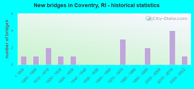
- New bridges - historical statistics
- 1Before 1900
- 11900-1909
- 21910-1919
- 11920-1929
- 11930-1939
- 31970-1979
- 21990-1999
- 42010-2019
- 12020-2022
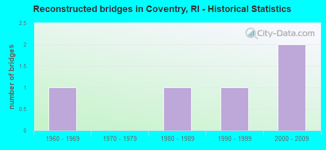
- Reconstructed bridges - Historical Statistics
- 11960-1969
- 01970-1979
- 11980-1989
- 11990-1999
- 22000-2009

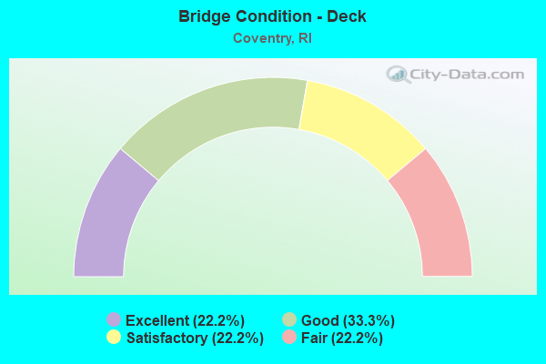
- Bridge Condition - Deck
- 22.2%Excellent
- 33.3%Good
- 22.2%Satisfactory
- 22.2%Fair
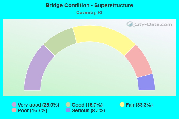
- Bridge Condition - Superstructure
- 25.0%Very good
- 16.7%Good
- 33.3%Fair
- 16.7%Poor
- 8.3%Serious
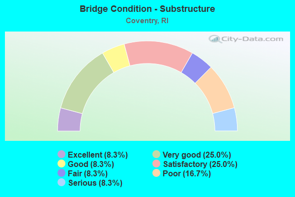
- Bridge Condition - Substructure
- 8.3%Excellent
- 25.0%Very good
- 8.3%Good
- 25.0%Satisfactory
- 8.3%Fair
- 16.7%Poor
- 8.3%Serious
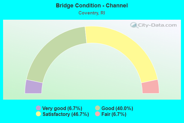
- Bridge Condition - Channel
- 6.7%Very good
- 40.0%Good
- 46.7%Satisfactory
- 6.7%Fair
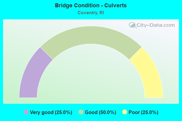
- Bridge Condition - Culverts
- 25.0%Very good
- 50.0%Good
- 25.0%Poor
Find on map >> Show street view
Structure Number: 32, Location: 0.01 Mi S of JCT RI 117 (Lat: 41.690047, Lng: -71.566617), Route carried "on" structure: City street , Year Built: 1919, Status: Open, Structure Length: 1.83m (6.00ft), Average Daily Traffic: 9,625 (year 2015), Truck Traffic: 10%, Average Future Daily Traffic: 11,550 (year 2036), Design Load: HS 20, Features Intersected: PAWTUXET RIVER SW BRANCH, Facility Carried by Structure: SOUTH MAIN ST
Minimum Vertical Clearance: 30+ m (98+ ft), Kilometerpoint: 1.493, Lanes on structure: 2, Owner: Town or Township Highway Agency, Approaching Roadway Width: 7.6m (24.9ft), Material/Design: Concrete, Design/Construction: Arch - Deck, Number Of Spans In Main Unit: 1, Length of Maximum Span: 18.3m (60.0ft), Curb or Sidewalk Widths: Left: 2.0m (6.6ft), Right: 2.0m (6.6ft), Curb-To-Curb Width: 7.6m (24.9ft), Out-to-Out Width: 12.3m (40.4ft)
Condition: Superstructure: Fair, Substructure: Satisfactory, Channel: Satisfactory, Operating Rating: 40.5 metric tons, Method Used To Determine Operating Rating: Load and Resistance Factor Rating (LRFR) rating reported by rating factor(RF) method using HL-93 loadings, Inventory Rating: 30.8 metric tons, Method Used To Determine Inventory Rating: Load and Resistance Factor Rating (LRFR) rating reported by rating factor(RF) method using HL-93 loadings, Structural Evaluation: Somewhat better than minimum adequacy, Deck Geometry: High priority of replacement, Waterway Adequacy: Superior to present desirable criteria, Approach Roadway Alignment: Equal to present minimum criteria, Length Of Structure Improvement: 1.95m (6.40ft), Designated Inspection Frequency: Every 24 months, Inspection Date: April 2020, Bridge Improvement Cost: $267,000, Roadway Improvement Cost: $27,000, Total Project Cost: $401,000
Find on map >> Show street view
Structure Number: 227, Location: 0.1 Mi S of JCT RI 117 (Lat: 41.691036, Lng: -71.693325), Route carried "on" structure: State highway 102, Year Built: 1927, Year Reconstructed: 1987, Status: Posted for load, Structure Length: 1.40m (4.59ft), Average Daily Traffic: 5,534 (year 2021), Truck Traffic: 11%, Average Future Daily Traffic: 6,087 (year 2041), Features Intersected: BRIDLE / HIKING TRAIL
Minimum Vertical Clearance: 30+ m (98+ ft), Kilometerpoint: 30.116, Lanes on structure: 2, Base Highway Network: Yes, Owner: State Highway Agency, Approaching Roadway Width: 11.0m (36.1ft), Material/Design: Concrete, Design/Construction: Arch - Deck, Number Of Spans In Main Unit: 1, Length of Maximum Span: 14.0m (45.9ft), Curb or Sidewalk Widths: Left: 1.1m (3.6ft), Right: 1.6m (5.2ft), Curb-To-Curb Width: 11.0m (36.1ft), Out-to-Out Width: 14.3m (46.9ft)
Condition: Superstructure: Fair, Substructure: Satisfactory, Operating Rating: 30.4 metric tons, Method Used To Determine Operating Rating: Load and Resistance Factor (LRFR), Inventory Rating: 23.5 metric tons, Method Used To Determine Inventory Rating: Load and Resistance Factor (LRFR), Structural Evaluation: Somewhat better than minimum adequacy, Deck Geometry: Meets minimum limits, Approach Roadway Alignment: Better than present minimum criteria, Bridge Posting: Required (Relationship of Operating Rating to Maximum Legal Load: 20.0 - 29.9% below), Length Of Structure Improvement: 2.13m (6.99ft), Designated Inspection Frequency: Every 24 months, Other Special Inspection Frequency: Every 12 months, Inspection Date: October 2021, Other Special Inspection Date: October 2021, Bridge Improvement Cost: $715,000, Roadway Improvement Cost: $72,000, Total Project Cost: $1,073,000, Wearing Surface/Protective System: Wearing Surface: Bituminous
Find on map >> Show street view
Structure Number: 2575, Location: 0.3 Mi N of JCT RI 3 (Lat: 41.686008, Lng: -71.560836), Route carried "on" structure: State highway 33, Year Built: 2021, Status: Open, Structure Length: 2.73m (8.96ft), Average Daily Traffic: 9,864 (year 2021), Truck Traffic: 8%, Average Future Daily Traffic: 10,850 (year 2041), Design Load: HL 93, Features Intersected: PAWTUXET RIVER
Minimum Vertical Clearance: 30+ m (98+ ft), Kilometerpoint: 0.359, Lanes on structure: 2, Owner: State Highway Agency, Approaching Roadway Width: 12.2m (40.0ft), Skew: 2 degrees, Material/Design: Steel, Design/Construction: Stringer/Multi-beam, Number Of Spans In Main Unit: 1, Length of Maximum Span: 25.9m (85.0ft), Curb or Sidewalk Widths: Left: 1.7m (5.6ft), Right: 1.7m (5.6ft), Curb-To-Curb Width: 6.5m (21.3ft), Out-to-Out Width: 16.5m (54.1ft)
Condition: Deck: Excellent, Superstructure: Very good, Substructure: Excellent, Channel: Satisfactory, Operating Rating: 83.3 metric tons, Method Used To Determine Operating Rating: Load and Resistance Factor Rating (LRFR) rating reported by rating factor(RF) method using HL-93 loadings, Inventory Rating: 64.2 metric tons, Method Used To Determine Inventory Rating: Load and Resistance Factor Rating (LRFR) rating reported by rating factor(RF) method using HL-93 loadings, Structural Evaluation: Equal to present desirable criteria, Deck Geometry: High priority of replacement, Waterway Adequacy: Equal to present desirable criteria, Approach Roadway Alignment: Better than present minimum criteria, Length Of Structure Improvement: 2.29m (7.51ft), Designated Inspection Frequency: Every 24 months, Underwater Inspection Frequency: Every 48 months, Inspection Date: December 2021, Bridge Improvement Cost: $364,000, Roadway Improvement Cost: $36,000, Total Project Cost: $546,000, Deck Structure Type: Concrete Cast-file-Place, Wearing Surface/Protective System: Wearing Surface: Bituminous, Membrane: Preformed Fabric
Find on map >> Show street view
Structure Number: 334, Location: 0.6 Mi W of JCT RI 3 (Lat: 41.673119, Lng: -71.607900), Route carried "on" structure: City street , Year Built: 1934, Status: Open, Structure Length: 1.10m (3.61ft), Average Daily Traffic: 4,870 (year 2021), Truck Traffic: 12%, Average Future Daily Traffic: 5,357 (year 2041), Design Load: HS 20, Features Intersected: JOHNSONS POND, Facility Carried by Structure: HILL FARM RD
Minimum Vertical Clearance: 30+ m (98+ ft), Kilometerpoint: 0.578, Lanes on structure: 2, Owner: State Highway Agency, Approaching Roadway Width: 8.2m (26.9ft), Skew: 2 degrees, Material/Design: Concrete, Design/Construction: Slab, Number Of Spans In Main Unit: 1, Length of Maximum Span: 9.1m (29.9ft), Curb-To-Curb Width: 8.4m (27.6ft), Out-to-Out Width: 10.4m (34.1ft)
Condition: Deck: Good, Superstructure: Fair, Substructure: Fair, Channel: Satisfactory, Operating Rating: 97.2 metric tons, Method Used To Determine Operating Rating: Load and Resistance Factor Rating (LRFR) rating reported by rating factor(RF) method using HL-93 loadings, Inventory Rating: 77.4 metric tons, Method Used To Determine Inventory Rating: Load and Resistance Factor Rating (LRFR) rating reported by rating factor(RF) method using HL-93 loadings, Structural Evaluation: Somewhat better than minimum adequacy, Deck Geometry: High priority of corrective action, Waterway Adequacy: Equal to present desirable criteria, Approach Roadway Alignment: Better than present minimum criteria, Length Of Structure Improvement: 0.91m (2.99ft), Designated Inspection Frequency: Every 24 months, Underwater Inspection Frequency: Every 48 months, Inspection Date: October 2021, Underwater Inspection Date: October 2021, Bridge Improvement Cost: $112,000, Roadway Improvement Cost: $11,000, Total Project Cost: $168,000, Deck Structure Type: Concrete Cast-file-Place, Wearing Surface/Protective System: Wearing Surface: Bituminous
Find on map >> Show street view
Structure Number: 397, Location: 0.1 Mi S of JCT RI 117 (Lat: 41.695542, Lng: -71.546953), Route carried "on" structure: City street , Year Built: 1900, Year Reconstructed: 2012, Status: Open, Structure Length: 2.80m (9.19ft), Average Daily Traffic: 5,919 (year 2021), Truck Traffic: 5%, Average Future Daily Traffic: 6,511 (year 2041), Design Load: HL 93, Features Intersected: PAWTUXET RIVER, Facility Carried by Structure: LAUREL AV
Minimum Vertical Clearance: 30.45m (99.90ft), Kilometerpoint: 1.302, Lanes on structure: 2, Owner: State Highway Agency, Approaching Roadway Width: 7.6m (24.9ft), Material/Design: Steel, Design/Construction: Stringer/Multi-beam, Number Of Spans In Main Unit: 1, Length of Maximum Span: 26.2m (86.0ft), Curb or Sidewalk Widths: Left: 1.2m (3.9ft), Right: 1.2m (3.9ft), Curb-To-Curb Width: 9.8m (32.2ft), Out-to-Out Width: 12.8m (42.0ft)
Condition: Deck: Good, Superstructure: Very good, Substructure: Very good, Channel: Good, Operating Rating: 54.8 metric tons, Method Used To Determine Operating Rating: Load and Resistance Factor Rating (LRFR) rating reported by rating factor(RF) method using HL-93 loadings, Inventory Rating: 42.1 metric tons, Method Used To Determine Inventory Rating: Load and Resistance Factor Rating (LRFR) rating reported by rating factor(RF) method using HL-93 loadings, Structural Evaluation: Equal to present desirable criteria, Deck Geometry: Meets minimum limits, Waterway Adequacy: Equal to present desirable criteria, Approach Roadway Alignment: Equal to present desirable criteria, Length Of Structure Improvement: 2.53m (8.30ft), Designated Inspection Frequency: Every 24 months, Inspection Date: September 2020, Bridge Improvement Cost: $615,000, Roadway Improvement Cost: $62,000, Total Project Cost: $923,000, Deck Structure Type: Concrete Cast-file-Place, Wearing Surface/Protective System: Wearing Surface: Monolithic Concrete, Deck Protection: Galvanized Reinforcing
Find on map >> Show street view
Structure Number: 431, Location: 0.8 Mi W of JCT RI 3 (Lat: 41.665244, Lng: -71.619208), Route carried "on" structure: City street , Year Built: 1997, Status: Open, Structure Length: 2.30m (7.55ft), Average Daily Traffic: 6,580 (year 2021), Truck Traffic: 11%, Average Future Daily Traffic: 7,238 (year 2041), Design Load: HS 25 or greater, Features Intersected: FLAT RIVER RESERVOIR, Facility Carried by Structure: HARKNEY HILL RD
Minimum Vertical Clearance: 30+ m (98+ ft), Kilometerpoint: 7.084, Lanes on structure: 2, Owner: State Highway Agency, Approaching Roadway Width: 7.9m (25.9ft), Material/Design: Prestressed concrete, Design/Construction: Box Beam or Girders - Multiple, Number Of Spans In Main Unit: 1, Length of Maximum Span: 21.3m (69.9ft), Curb-To-Curb Width: 6.7m (22.0ft), Out-to-Out Width: 7.3m (24.0ft)
Condition: Deck: Good, Superstructure: Good, Substructure: Good, Channel: Satisfactory, Operating Rating: 67.1 metric tons, Method Used To Determine Operating Rating: Load and Resistance Factor Rating (LRFR) rating reported by rating factor(RF) method using HL-93 loadings, Inventory Rating: 51.8 metric tons, Method Used To Determine Inventory Rating: Load and Resistance Factor Rating (LRFR) rating reported by rating factor(RF) method using HL-93 loadings, Structural Evaluation: Better than present minimum criteria, Deck Geometry: High priority of replacement, Waterway Adequacy: Equal to present desirable criteria, Approach Roadway Alignment: Equal to present minimum criteria, Length Of Structure Improvement: 1.49m (4.89ft), Designated Inspection Frequency: Every 24 months, Underwater Inspection Frequency: Every 48 months, Inspection Date: October 2021, Underwater Inspection Date: October 2021, Bridge Improvement Cost: $1,814,000, Roadway Improvement Cost: $181,000, Total Project Cost: $2,721,000, Deck Structure Type: Concrete Precast Panels, Wearing Surface/Protective System: Wearing Surface: Bituminous, Membrane: Preformed Fabric
Find on map >> Show street view
Structure Number: 836, Location: 0.1 Mi E of JCT MAIN ST (Lat: 41.724011, Lng: -71.535733), Route carried "on" structure: City street , Year Built: 1919, Year Reconstructed: 1967, Status: Posted for load, Structure Length: 2.93m (9.61ft), Average Daily Traffic: 1,756 (year 2021), Truck Traffic: 3%, Average Future Daily Traffic: 1,932 (year 2041), Design Load: HS 20, Features Intersected: PAWTUXET RIVER N BRANCH, Facility Carried by Structure: LINCOLN AV
Minimum Vertical Clearance: 30+ m (98+ ft), Kilometerpoint: 3.106, Lanes on structure: 2, Owner: Town or Township Highway Agency, Approaching Roadway Width: 9.1m (29.9ft), Skew: 1 degrees, Material/Design: Steel, Design/Construction: Stringer/Multi-beam, Number Of Spans In Main Unit: 1, Length of Maximum Span: 28.2m (92.5ft), Curb or Sidewalk Widths: Left: 0.6m (2.0ft), Right: 1.5m (4.9ft), Curb-To-Curb Width: 9.1m (29.9ft), Out-to-Out Width: 12.0m (39.4ft)
Condition: Deck: Satisfactory, Superstructure: Poor, Substructure: Satisfactory, Channel: Good, Operating Rating: 5.5 metric tons, Method Used To Determine Operating Rating: Load and Resistance Factor Rating (LRFR) rating reported by rating factor(RF) method using HL-93 loadings, Inventory Rating: 4.2 metric tons, Method Used To Determine Inventory Rating: Load and Resistance Factor Rating (LRFR) rating reported by rating factor(RF) method using HL-93 loadings, Structural Evaluation: High priority of corrective action, Deck Geometry: Somewhat better than minimum adequacy, Waterway Adequacy: Superior to present desirable criteria, Approach Roadway Alignment: Better than present minimum criteria, Bridge Posting: Required (Relationship of Operating Rating to Maximum Legal Load: > 39.9% below), Length Of Structure Improvement: 2.87m (9.42ft), Designated Inspection Frequency: Every 24 months, Other Special Inspection Frequency: Every 12 months, Inspection Date: November 2021, Other Special Inspection Date: November 2021, Total Project Cost: $1,074,000, Deck Structure Type: Concrete Cast-file-Place, Wearing Surface/Protective System: Wearing Surface: Bituminous, Membrane: Built-up
Find on map >> Show street view
Structure Number: 842, Location: 0.1 Mi S of JCT Main St (Lat: 41.730517, Lng: -71.546456), Route carried "on" structure: City street , Year Built: 1888, Year Reconstructed: 1998, Status: Closed, Structure Length: 4.05m (13.29ft), Average Daily Traffic: 910 (year 1999), Truck Traffic: 10%, Average Future Daily Traffic: 1,092 (year 2036), Features Intersected: PAWTUXET RIVER N BRANCH, Facility Carried by Structure: HILL ST
Minimum Vertical Clearance: 5.36m (17.59ft), Kilometerpoint: 0.056, Lanes on structure: 1, Owner: Town or Township Highway Agency, Approaching Roadway Width: 4.9m (16.1ft), Material/Design: Aluminum, Iron, Design/Construction: Truss - Thru, Number Of Spans In Main Unit: 1, Length of Maximum Span: 38.7m (127.0ft), Curb-To-Curb Width: 4.9m (16.1ft), Out-to-Out Width: 5.5m (18.0ft)
Condition: Deck: Satisfactory, Superstructure: Serious, Substructure: Poor, Channel: Fair, Bridge Posting: Required (Relationship of Operating Rating to Maximum Legal Load: > 39.9% below), Length Of Structure Improvement: 3.93m (12.89ft), Designated Inspection Frequency: Every 24 months, Critical Feature Inspection Frequency: Every 12 months, Other Special Inspection Frequency: Every 12 months, Inspection Date: September 2021, Critical Feature Inspection Date: September 2021, Other Special Inspection Date: September 2021, Bridge Improvement Cost: $504,000, Roadway Improvement Cost: $50,000, Total Project Cost: $755,000, Deck Structure Type: Wood or Timber, Wearing Surface/Protective System: Wearing Surface: Wood or Timber
Find on map >> Show street view
Structure Number: 843, Location: 0.3 Mi N of JCT RI 117 (Lat: 41.714483, Lng: -71.652278), Route carried "on" structure: City street , Year Built: 1978, Status: Open, Structure Length: 1.09m (3.58ft), Average Daily Traffic: 1,386 (year 2021), Truck Traffic: 9%, Average Future Daily Traffic: 1,525 (year 2041), Design Load: HS 20, Features Intersected: FLAT RIVER, Facility Carried by Structure: MAPLE VALLEY RD
Minimum Vertical Clearance: 30+ m (98+ ft), Kilometerpoint: 4.801, Lanes on structure: 2, Owner: Town or Township Highway Agency, Approaching Roadway Width: 5.9m (19.4ft), Material/Design: Steel, Design/Construction: Culvert, Number Of Spans In Main Unit: 2, Length of Maximum Span: 5.3m (17.4ft), Curb-To-Curb Width: 5.9m (19.4ft), Out-to-Out Width: 5.9m (19.4ft)
Condition: Channel: Good, Culverts: Poor, Operating Rating: 44.4 metric tons, Method Used To Determine Operating Rating: Load and Resistance Factor Rating (LRFR) rating reported by rating factor(RF) method using HL-93 loadings, Inventory Rating: 34.3 metric tons, Method Used To Determine Inventory Rating: Load and Resistance Factor Rating (LRFR) rating reported by rating factor(RF) method using HL-93 loadings, Structural Evaluation: Meets minimum limits, Deck Geometry: High priority of replacement, Waterway Adequacy: Equal to present desirable criteria, Approach Roadway Alignment: Better than present minimum criteria, Length Of Structure Improvement: 1.37m (4.49ft), Designated Inspection Frequency: Every 24 months, Other Special Inspection Frequency: Every 12 months, Inspection Date: March 2020, Other Special Inspection Date: March 2021, Bridge Improvement Cost: $57,000, Roadway Improvement Cost: $6,000, Total Project Cost: $86,000
Find on map >> Show street view
Structure Number: 8445, Location: 0.5 Mi N of JCT RI 14 (Lat: 41.720075, Lng: -71.757631), Route carried "on" structure: City street , Year Built: 2019, Status: Open, Structure Length: 1.34m (4.40ft), Average Daily Traffic: 81 (year 2019), Truck Traffic: 22%, Average Future Daily Traffic: 89 (year 2039), Design Load: HL 93, Features Intersected: MOOSUP RIVER, Facility Carried by Structure: BARBS HILL RD
Minimum Vertical Clearance: 30+ m (98+ ft), Kilometerpoint: 0.151, Lanes on structure: 1, Owner: Town or Township Highway Agency, Approaching Roadway Width: 5.5m (18.0ft), Material/Design: Concrete, Design/Construction: Arch - Deck, Number Of Spans In Main Unit: 1, Length of Maximum Span: 13.4m (44.0ft), Curb or Sidewalk Widths: Left: 0.5m (1.6ft), Right: 0.5m (1.6ft), Curb-To-Curb Width: 5.5m (18.0ft), Out-to-Out Width: 6.6m (21.7ft)
Condition: Deck: Excellent, Superstructure: Very good, Substructure: Very good, Channel: Very good, Operating Rating: 49.2 metric tons, Method Used To Determine Operating Rating: Load and Resistance Factor Rating (LRFR) rating reported by rating factor(RF) method using HL-93 loadings, Inventory Rating: 37.9 metric tons, Method Used To Determine Inventory Rating: Load and Resistance Factor Rating (LRFR) rating reported by rating factor(RF) method using HL-93 loadings, Structural Evaluation: Equal to present desirable criteria, Deck Geometry: Meets minimum limits, Waterway Adequacy: Equal to present desirable criteria, Approach Roadway Alignment: Equal to present minimum criteria, Length Of Structure Improvement: 0.88m (2.89ft), Designated Inspection Frequency: Every 24 months, Inspection Date: December 2021, Bridge Improvement Cost: $639,000, Roadway Improvement Cost: $64,000, Total Project Cost: $959,000, Deck Structure Type: Concrete Cast-file-Place, Wearing Surface/Protective System: Wearing Surface: Bituminous, Membrane: Preformed Fabric
Find on map >> Show street view
Structure Number: 845, Location: 0.1 Mi N of JCT RI 117 (Lat: 41.699147, Lng: -71.746261), Route carried "on" structure: City street , Year Built: 1970, Year Reconstructed: 2000, Status: Posted for load, Structure Length: 1.11m (3.64ft), Average Daily Traffic: 42 (year 2021), Truck Traffic: 14%, Average Future Daily Traffic: 46 (year 2041), Design Load: HS 20, Features Intersected: BUCKS HORN BROOK, Facility Carried by Structure: CAHOONE RD
Minimum Vertical Clearance: 30+ m (98+ ft), Kilometerpoint: 0.235, Lanes on structure: 1, Owner: Town or Township Highway Agency, Approaching Roadway Width: 4.6m (15.1ft), Material/Design: Steel continuous, Design/Construction: Stringer/Multi-beam, Number Of Spans In Main Unit: 2, Length of Maximum Span: 5.6m (18.4ft), Curb-To-Curb Width: 4.6m (15.1ft), Out-to-Out Width: 4.9m (16.1ft)
Condition: Deck: Fair, Superstructure: Fair, Substructure: Serious, Channel: Satisfactory, Operating Rating: 7.8 metric tons, Method Used To Determine Operating Rating: Load and Resistance Factor Rating (LRFR) rating reported by rating factor(RF) method using HL-93 loadings, Inventory Rating: 6.2 metric tons, Method Used To Determine Inventory Rating: Load and Resistance Factor Rating (LRFR) rating reported by rating factor(RF) method using HL-93 loadings, Structural Evaluation: High priority of corrective action, Deck Geometry: Better than present minimum criteria, Waterway Adequacy: Better than present minimum criteria, Approach Roadway Alignment: Better than present minimum criteria, Bridge Posting: Required (Relationship of Operating Rating to Maximum Legal Load: > 39.9% below), Length Of Structure Improvement: 1.11m (3.64ft), Designated Inspection Frequency: Every 24 months, Other Special Inspection Frequency: Every 12 months, Inspection Date: September 2021, Other Special Inspection Date: September 2021, Bridge Improvement Cost: $680,000, Roadway Improvement Cost: $68,000, Total Project Cost: $1,020,000, Deck Structure Type: Wood or Timber, Wearing Surface/Protective System: Wearing Surface: Bituminous
Find on map >> Show street view
Structure Number: 846, Location: 1.0 Mi W of JCT Lws Fm Rd (Lat: 41.681381, Lng: -71.771922), Route carried "on" structure: City street , Year Built: 1975, Status: Posted for load, Structure Length: 0.98m (3.22ft), Average Daily Traffic: 26 (year 2021), Average Future Daily Traffic: 29 (year 2041), Design Load: HS 20, Features Intersected: ROARING BROOK, Facility Carried by Structure: NICHOLAS RD
Minimum Vertical Clearance: 30+ m (98+ ft), Kilometerpoint: 1.077, Lanes on structure: 1, Owner: Town or Township Highway Agency, Approaching Roadway Width: 6.1m (20.0ft), Material/Design: Steel, Design/Construction: Stringer/Multi-beam, Number Of Spans In Main Unit: 1, Length of Maximum Span: 8.8m (28.9ft), Curb-To-Curb Width: 4.8m (15.7ft), Out-to-Out Width: 5.0m (16.4ft)
Condition: Deck: Fair, Superstructure: Poor, Substructure: Poor, Channel: Good, Operating Rating: 11.3 metric tons, Method Used To Determine Operating Rating: Load and Resistance Factor Rating (LRFR) rating reported by rating factor(RF) method using HL-93 loadings, Inventory Rating: 8.7 metric tons, Method Used To Determine Inventory Rating: Load and Resistance Factor Rating (LRFR) rating reported by rating factor(RF) method using HL-93 loadings, Structural Evaluation: High priority of corrective action, Deck Geometry: Equal to present desirable criteria, Waterway Adequacy: Better than present minimum criteria, Approach Roadway Alignment: Equal to present minimum criteria, Bridge Posting: Required (Relationship of Operating Rating to Maximum Legal Load: > 39.9% below), Length Of Structure Improvement: 0.98m (3.22ft), Designated Inspection Frequency: Every 24 months, Other Special Inspection Frequency: Every 12 months, Inspection Date: July 2020, Other Special Inspection Date: July 2021, Bridge Improvement Cost: $297,000, Roadway Improvement Cost: $30,000, Total Project Cost: $446,000, Deck Structure Type: Concrete Cast-file-Place, Wearing Surface/Protective System: Wearing Surface: Monolithic Concrete
Find on map >> Show street view
Structure Number: 847, Location: 0.2 Mi S of JCT RI 117 (Lat: 41.695231, Lng: -71.756883), Route carried "on" structure: City street , Year Built: 1995, Status: Open, Structure Length: 1.31m (4.30ft), Average Daily Traffic: 188 (year 2021), Truck Traffic: 9%, Average Future Daily Traffic: 207 (year 2041), Design Load: HS 20, Features Intersected: BUCKS HORN BROOK, Facility Carried by Structure: LEWIS FARM RD
Minimum Vertical Clearance: 30+ m (98+ ft), Kilometerpoint: 0.822, Lanes on structure: 2, Owner: Town or Township Highway Agency, Approaching Roadway Width: 7.3m (24.0ft), Material/Design: Concrete, Design/Construction: Arch - Deck, Number Of Spans In Main Unit: 1, Length of Maximum Span: 10.4m (34.1ft), Curb-To-Curb Width: 7.3m (24.0ft), Out-to-Out Width: 8.5m (27.9ft)
Condition: Superstructure: Good, Substructure: Very good, Channel: Good, Operating Rating: 87.1 metric tons, Method Used To Determine Operating Rating: Load Testing, Inventory Rating: 64.4 metric tons, Method Used To Determine Inventory Rating: Load Testing, Structural Evaluation: Better than present minimum criteria, Deck Geometry: Somewhat better than minimum adequacy, Waterway Adequacy: Superior to present desirable criteria, Approach Roadway Alignment: Equal to present minimum criteria, Length Of Structure Improvement: 0.76m (2.49ft), Designated Inspection Frequency: Every 24 months, Inspection Date: July 2020, Bridge Improvement Cost: $457,000, Roadway Improvement Cost: $46,000, Total Project Cost: $686,000, Wearing Surface/Protective System: Wearing Surface: Gravel
Find on map >> Show street view
Structure Number: 12365, Location: 0.1 MiS ofJCTMaple Valy (Lat: 41.716822, Lng: -71.663283), Route carried "on" structure: City street , Year Built: 2016, Status: Open, Structure Length: 1.87m (6.14ft), Average Daily Traffic: 106 (year 2021), Truck Traffic: 9%, Average Future Daily Traffic: 117 (year 2041), Design Load: HS 20, Features Intersected: FLAT RIVER, Facility Carried by Structure: HAMMET RD
Minimum Vertical Clearance: 30.45m (99.90ft), Kilometerpoint: 1.374, Lanes on structure: 2, Owner: Town or Township Highway Agency, Approaching Roadway Width: 6.7m (22.0ft), Material/Design: Concrete, Design/Construction: Culvert, Number Of Spans In Main Unit: 7, Length of Maximum Span: 1.8m (5.9ft), Curb-To-Curb Width: 6.7m (22.0ft), Out-to-Out Width: 6.7m (22.0ft)
Condition: Channel: Satisfactory, Culverts: Good, Structural Evaluation: Better than present minimum criteria, Deck Geometry: Meets minimum limits, Waterway Adequacy: Somewhat better than minimum adequacy, Approach Roadway Alignment: Equal to present desirable criteria, Length Of Structure Improvement: 0.99m (3.25ft), Designated Inspection Frequency: Every 24 months, Inspection Date: August 2020, Bridge Improvement Cost: $270,000, Roadway Improvement Cost: $27,000, Total Project Cost: $300,000 ( Estimate for 2015), Wearing Surface/Protective System: Wearing Surface: Bituminous
Find on map >> Show street view
Structure Number: 1237, Location: 0.9 Mi N of RI 117 (Lat: 41.717433, Lng: -71.663225), Route carried "on" structure: City street _, Year Built: 2016, Status: Open, Structure Length: 1.07m (3.51ft), Average Daily Traffic: 106 (year 2021), Truck Traffic: 9%, Average Future Daily Traffic: 117 (year 2041), Features Intersected: Whaley Brook, Facility Carried by Structure: HAMMET RD
Minimum Vertical Clearance: 30+ m (98+ ft), Kilometerpoint: 1.444, Lanes on structure: 2, Owner: Town or Township Highway Agency, Approaching Roadway Width: 5.9m (19.4ft), Skew: 3 degrees, Material/Design: Concrete, Design/Construction: Culvert, Number Of Spans In Main Unit: 5, Length of Maximum Span: 1.2m (3.9ft), Curb-To-Curb Width: 5.9m (19.4ft), Out-to-Out Width: 5.9m (19.4ft)
Condition: Channel: Good, Culverts: Very good, Operating Rating: 97.2 metric tons, Method Used To Determine Operating Rating: Load and Resistance Factor Rating (LRFR) rating reported by rating factor(RF) method using HL-93 loadings, Inventory Rating: 78.4 metric tons, Method Used To Determine Inventory Rating: Load and Resistance Factor Rating (LRFR) rating reported by rating factor(RF) method using HL-93 loadings, Structural Evaluation: Equal to present desirable criteria, Deck Geometry: High priority of corrective action, Waterway Adequacy: Better than present minimum criteria, Approach Roadway Alignment: Equal to present desirable criteria, Designated Inspection Frequency: Every 24 months, Inspection Date: August 2020, Wearing Surface/Protective System: Wearing Surface: Bituminous
Find on map >> Show street view
Structure Number: 1239, Location: 0.17 MiS ofJCTMaple Valy (Lat: 41.717125, Lng: -71.663250), Route carried "on" structure: City street , Year Built: 2016, Status: Open, Structure Length: 1.19m (3.90ft), Average Daily Traffic: 106 (year 2021), Truck Traffic: 9%, Average Future Daily Traffic: 117 (year 2041), Features Intersected: Flat River Tributary, Facility Carried by Structure: HAMMET RD
Minimum Vertical Clearance: 30.45m (99.90ft), Kilometerpoint: 1.408, Lanes on structure: 2, Owner: Town or Township Highway Agency, Approaching Roadway Width: 6.7m (22.0ft), Material/Design: Concrete, Design/Construction: Culvert, Number Of Spans In Main Unit: 5, Length of Maximum Span: 1.5m (4.9ft), Curb-To-Curb Width: 6.7m (22.0ft), Out-to-Out Width: 6.7m (22.0ft)
Condition: Channel: Satisfactory, Culverts: Good, Structural Evaluation: Better than present minimum criteria, Deck Geometry: Meets minimum limits, Waterway Adequacy: Somewhat better than minimum adequacy, Approach Roadway Alignment: Better than present minimum criteria, Length Of Structure Improvement: 0.99m (3.25ft), Designated Inspection Frequency: Every 24 months, Inspection Date: November 2020, Bridge Improvement Cost: $270,000, Roadway Improvement Cost: $27,000, Total Project Cost: $300,000 ( Estimate for 2015), Wearing Surface/Protective System: Wearing Surface: Bituminous