Bridge Statistics for Darien, Wisconsin (WI)
Condition, Traffic, Stress, Structural Evaluation, Project Costs
- National Bridge Inventory (NBI) Statistics
- 33Number of bridges
- 354ft / 108mTotal length
- $2,197,000Total costs
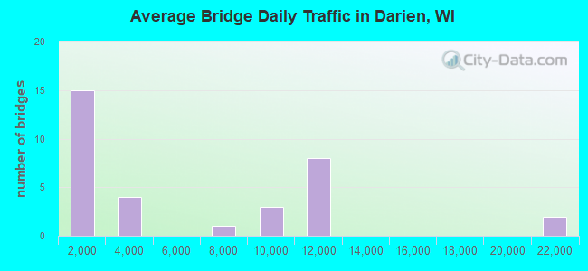
- 170,013Total average daily traffic
- 22,712Total average daily truck traffic
- National Bridge Inventory (NBI) Registered Bridges for Darien
- No street view available for this location
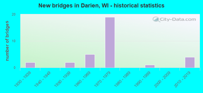
- New bridges - historical statistics
- 21930-1939
- 21950-1959
- 51960-1969
- 191970-1979
- 11990-1999
- 42010-2019
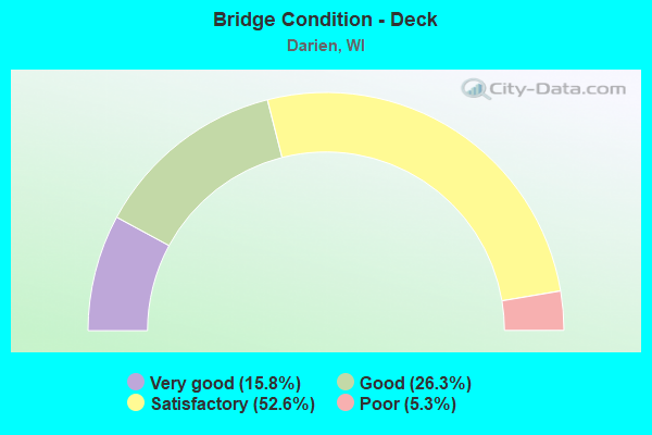
- Bridge Condition - Deck
- 15.8%Very good
- 26.3%Good
- 52.6%Satisfactory
- 5.3%Poor
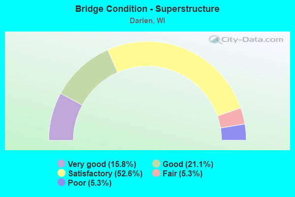
- Bridge Condition - Superstructure
- 15.8%Very good
- 21.1%Good
- 52.6%Satisfactory
- 5.3%Fair
- 5.3%Poor
- Bridge Condition - Substructure
- 21.1%Very good
- 36.8%Good
- 26.3%Satisfactory
- 5.3%Fair
- 5.3%Poor
- 5.3%Critical
- Bridge Condition - Channel
- 18.8%Excellent
- 25.0%Very good
- 43.8%Good
- 12.5%Satisfactory
- Bridge Condition - Culverts
- 16.7%Good
- 50.0%Satisfactory
- 16.7%Fair
- 16.7%Serious
Find on map >> Show street view
Structure Number: B640012, Location: 4.4M N JCT STH 67 (Lat: 42.572031, Lng: -88.707811), Route carried "on" structure: City street , Year Built: 1956, Status: Open, Structure Length: 1.07m (3.51ft), Average Daily Traffic: 235 (year 2019), Average Future Daily Traffic: 258 (year 2040), Design Load: H 15, Features Intersected: BR LITTLE TURTLE CREEK, Facility Carried by Structure: LRD PETERS RD
Minimum Vertical Clearance: 30+ m (98+ ft), Kilometerpoint: 0.000, Lanes on structure: 2, Owner: Town or Township Highway Agency, Approaching Roadway Width: 7.3m (24.0ft), Material/Design: Steel, Design/Construction: Stringer/Multi-beam, Number Of Spans In Main Unit: 1, Length of Maximum Span: 10.4m (34.1ft), Curb-To-Curb Width: 9.2m (30.2ft), Out-to-Out Width: 9.9m (32.5ft)
Condition: Deck: Satisfactory, Superstructure: Satisfactory, Substructure: Critical, Channel: Very good, Operating Rating: 37.6 metric tons, Method Used To Determine Operating Rating: Load Factor (LF), Inventory Rating: 22.7 metric tons, Method Used To Determine Inventory Rating: Load Factor (LF), Structural Evaluation: High priority of replacement, Deck Geometry: Equal to present minimum criteria, Waterway Adequacy: Equal to present desirable criteria, Approach Roadway Alignment: Equal to present desirable criteria, Length Of Structure Improvement: 1.52m (4.99ft), Designated Inspection Frequency: Every 12 months, Inspection Date: August 2021, Bridge Improvement Cost: $117,000, Roadway Improvement Cost: $11,000, Total Project Cost: $176,000 ( Estimate for 2021), Deck Structure Type: Concrete Cast-file-Place, Wearing Surface/Protective System: Wearing Surface: Monolithic Concrete
Find on map >> Show street view
Structure Number: B640014, Location: 0.8M W JCT CTH C (Lat: 42.585003, Lng: -88.741303), Route carried "on" structure: County highway , Year Built: 1958, Status: Open, Structure Length: 1.37m (4.49ft), Average Daily Traffic: 2,100 (year 2018), Average Future Daily Traffic: 2,138 (year 2039), Design Load: HS 20, Features Intersected: BR LITTLE TURTLE CREEK, Facility Carried by Structure: CTH X
Minimum Vertical Clearance: 30+ m (98+ ft), Kilometerpoint: 0.000, Lanes on structure: 2, Owner: County Highway Agency, Approaching Roadway Width: 10.4m (34.1ft), Material/Design: Concrete continuous, Design/Construction: Culvert, Number Of Spans In Main Unit: 4, Length of Maximum Span: 3.0m (9.8ft)
Condition: Channel: Very good, Culverts: Satisfactory, Operating Rating: 53.9 metric tons, Method Used To Determine Operating Rating: Field evaluation and documented engineering judgment, Inventory Rating: 32.4 metric tons, Method Used To Determine Inventory Rating: Field evaluation and documented engineering judgment, Structural Evaluation: Equal to present minimum criteria, Waterway Adequacy: Equal to present desirable criteria, Approach Roadway Alignment: Equal to present desirable criteria, Designated Inspection Frequency: Every 24 months, Inspection Date: August 2020, Deck Structure Type: Concrete Cast-file-Place, Wearing Surface/Protective System: Wearing Surface: Bituminous
Find on map >> Show street view
Structure Number: B640016, Location: 0.4M S JCT CTH X (Lat: 42.583328, Lng: -88.727269), Route carried "on" structure: County highway , Year Built: 1960, Status: Open, Structure Length: 7.29m (23.92ft), Average Daily Traffic: 1,500 (year 2018), Average Future Daily Traffic: 1,045 (year 2039), Design Load: H 20, Features Intersected: CMSTPP RR, Facility Carried by Structure: CTH C
Minimum Vertical Clearance: 30+ m (98+ ft), Kilometerpoint: 0.000, Lanes on structure: 2, Owner: County Highway Agency, Approaching Roadway Width: 11.0m (36.1ft), Material/Design: Prestressed concrete, Design/Construction: Stringer/Multi-beam, Number Of Spans In Main Unit: 4, Length of Maximum Span: 19.1m (62.7ft), Curb-To-Curb Width: 7.9m (25.9ft), Out-to-Out Width: 9.8m (32.2ft)
Condition: Deck: Good, Superstructure: Fair, Substructure: Good, Channel: Very good, Operating Rating: 70.2 metric tons, Method Used To Determine Operating Rating: Load Factor (LF), Inventory Rating: 42.1 metric tons, Method Used To Determine Inventory Rating: Load Factor (LF), Structural Evaluation: Somewhat better than minimum adequacy, Deck Geometry: Meets minimum limits, Underclear: Better than present minimum criteria, Waterway Adequacy: Equal to present desirable criteria, Approach Roadway Alignment: Equal to present desirable criteria, Designated Inspection Frequency: Every 24 months, Inspection Date: August 2020, Deck Structure Type: Concrete Cast-file-Place, Wearing Surface/Protective System: Wearing Surface: Monolithic Concrete
Find on map >> Show street view
Structure Number: B640078, Location: 1.7M E JCT STH 89 (Lat: 42.643156, Lng: -88.712361), Route carried "on" structure: State highway 11, Year Built: 1992, Status: Open, Structure Length: 2.12m (6.96ft), Average Daily Traffic: 3,300 (year 2018), Truck Traffic: 6%, Average Future Daily Traffic: 7,150 (year 2040), Design Load: HS 20, Features Intersected: TURTLE CREEK
Minimum Vertical Clearance: 30+ m (98+ ft), Kilometerpoint: 0.000, Lanes on structure: 2, Owner: State Highway Agency, Approaching Roadway Width: 13.4m (44.0ft), Material/Design: Concrete continuous, Design/Construction: Slab, Number Of Spans In Main Unit: 2, Length of Maximum Span: 10.5m (34.4ft), Curb-To-Curb Width: 13.4m (44.0ft), Out-to-Out Width: 14.1m (46.3ft)
Condition: Deck: Good, Superstructure: Good, Substructure: Good, Channel: Very good, Operating Rating: 60.4 metric tons, Method Used To Determine Operating Rating: Load Factor (LF), Inventory Rating: 35.6 metric tons, Method Used To Determine Inventory Rating: Load Factor (LF), Structural Evaluation: Better than present minimum criteria, Deck Geometry: Better than present minimum criteria, Waterway Adequacy: Equal to present desirable criteria, Approach Roadway Alignment: Equal to present desirable criteria, Designated Inspection Frequency: Every 48 months, Inspection Date: August 2021, Deck Structure Type: Concrete Cast-file-Place, Wearing Surface/Protective System: Wearing Surface: Bituminous, Deck Protection: Epoxy Coated Reinforcing
Find on map >> Show street view
Structure Number: B640132, Location: 0.9 MI N JCT CTH X (Lat: 42.613261, Lng: -88.707892), Route carried "on" structure: City street , Year Built: 1976, Status: Open, Structure Length: 7.40m (24.28ft), Average Daily Traffic: 375 (year 2019), Average Future Daily Traffic: 375 (year 2040), Design Load: H 20, Features Intersected: IH 43, Facility Carried by Structure: LRD WISCONSIN ST (
Minimum Vertical Clearance: 30+ m (98+ ft), Kilometerpoint: 0.000, Lanes on structure: 2, Lanes under structure: 4, Owner: State Highway Agency, Approaching Roadway Width: 11.0m (36.1ft), Skew: 1 degrees, Material/Design: Steel continuous, Design/Construction: Stringer/Multi-beam, Number Of Spans In Main Unit: 2, Length of Maximum Span: 36.4m (119.4ft), Curb-To-Curb Width: 10.4m (34.1ft), Out-to-Out Width: 11.5m (37.7ft)
Condition: Deck: Very good, Superstructure: Good, Substructure: Good, Operating Rating: 58.8 metric tons, Method Used To Determine Operating Rating: Load Factor (LF), Inventory Rating: 34.0 metric tons, Method Used To Determine Inventory Rating: Load Factor (LF), Structural Evaluation: Better than present minimum criteria, Deck Geometry: Better than present minimum criteria, Underclear: Equal to present minimum criteria, Approach Roadway Alignment: Equal to present desirable criteria, Designated Inspection Frequency: Every 48 months, Inspection Date: June 2021, Deck Structure Type: Concrete Cast-file-Place, Wearing Surface/Protective System: Wearing Surface: Low Slump Concrete
Find on map >> Show street view
Structure Number: B640133, Location: 6.3 MI S JCT STH 50 (Lat: 42.609383, Lng: -88.724192), Route carried "on" structure: Interstate 43, Year Built: 1976, Status: Open, Structure Length: 6.32m (20.73ft), Average Daily Traffic: 10,100 (year 2018), Truck Traffic: 19%, Average Future Daily Traffic: 7,720 (year 2040), Design Load: HS 20, Features Intersected: USH 14
Minimum Vertical Clearance: 30+ m (98+ ft), Kilometerpoint: 0.000, Lanes on structure: 2, Lanes under structure: 4, Base Highway Network: Yes, Owner: State Highway Agency, Approaching Roadway Width: 12.2m (40.0ft), Skew: 1 degrees, Material/Design: Steel continuous, Design/Construction: Stringer/Multi-beam, Number Of Spans In Main Unit: 2, Length of Maximum Span: 31.4m (103.0ft), Curb-To-Curb Width: 12.2m (40.0ft), Out-to-Out Width: 13.4m (44.0ft)
Condition: Deck: Satisfactory, Superstructure: Satisfactory, Substructure: Good, Operating Rating: 55.5 metric tons, Method Used To Determine Operating Rating: Load Factor (LF), Inventory Rating: 32.4 metric tons, Method Used To Determine Inventory Rating: Load Factor (LF), Structural Evaluation: Equal to present minimum criteria, Deck Geometry: Better than present minimum criteria, Underclear: Better than present minimum criteria, Approach Roadway Alignment: Equal to present desirable criteria, Designated Inspection Frequency: Every 24 months, Inspection Date: June 2021, Deck Structure Type: Concrete Cast-file-Place, Wearing Surface/Protective System: Wearing Surface: Low Slump Concrete
Find on map >> Show street view
Structure Number: B640134, Location: 8.3 MI N JCT STH 140 (Lat: 42.608808, Lng: -88.724450), Route carried "on" structure: Interstate 43, Year Built: 1975, Status: Open, Structure Length: 6.32m (20.73ft), Average Daily Traffic: 10,100 (year 2018), Truck Traffic: 19%, Average Future Daily Traffic: 7,720 (year 2040), Design Load: HS 20, Features Intersected: USH 14
Minimum Vertical Clearance: 30+ m (98+ ft), Kilometerpoint: 0.000, Lanes on structure: 2, Lanes under structure: 4, Base Highway Network: Yes, Owner: State Highway Agency, Approaching Roadway Width: 12.2m (40.0ft), Skew: 1 degrees, Material/Design: Steel continuous, Design/Construction: Stringer/Multi-beam, Number Of Spans In Main Unit: 2, Length of Maximum Span: 31.4m (103.0ft), Curb-To-Curb Width: 12.2m (40.0ft), Out-to-Out Width: 13.4m (44.0ft)
Condition: Deck: Satisfactory, Superstructure: Satisfactory, Substructure: Satisfactory, Operating Rating: 55.5 metric tons, Method Used To Determine Operating Rating: Load Factor (LF), Inventory Rating: 32.4 metric tons, Method Used To Determine Inventory Rating: Load Factor (LF), Structural Evaluation: Equal to present minimum criteria, Deck Geometry: Better than present minimum criteria, Underclear: Better than present minimum criteria, Approach Roadway Alignment: Equal to present desirable criteria, Designated Inspection Frequency: Every 24 months, Inspection Date: June 2021, Deck Structure Type: Concrete Cast-file-Place, Wearing Surface/Protective System: Wearing Surface: Low Slump Concrete
Find on map >> Show street view
Structure Number: B640135, Location: 2.0 MI S JCT USH 14 (Lat: 42.588614, Lng: -88.754114), Route carried "on" structure: Interstate 43, Year Built: 1976, Status: Open, Structure Length: 4.68m (15.35ft), Average Daily Traffic: 10,100 (year 2018), Truck Traffic: 12%, Average Future Daily Traffic: 11,280 (year 2039), Design Load: HS 20, Features Intersected: CMSTPP RR
Minimum Vertical Clearance: 30+ m (98+ ft), Kilometerpoint: 0.000, Lanes on structure: 2, Base Highway Network: Yes, Owner: State Highway Agency, Approaching Roadway Width: 12.2m (40.0ft), Skew: 1 degrees, Material/Design: Prestressed concrete continuous, Design/Construction: Stringer/Multi-beam, Number Of Spans In Main Unit: 3, Length of Maximum Span: 17.7m (58.1ft), Curb-To-Curb Width: 12.2m (40.0ft), Out-to-Out Width: 13.0m (42.7ft)
Condition: Deck: Satisfactory, Superstructure: Satisfactory, Substructure: Satisfactory, Operating Rating: 53.9 metric tons, Method Used To Determine Operating Rating: Load Factor (LF), Inventory Rating: 34.0 metric tons, Method Used To Determine Inventory Rating: Load Factor (LF), Structural Evaluation: Equal to present minimum criteria, Deck Geometry: Better than present minimum criteria, Underclear: Better than present minimum criteria, Approach Roadway Alignment: Equal to present desirable criteria, Designated Inspection Frequency: Every 24 months, Inspection Date: August 2021, Deck Structure Type: Concrete Cast-file-Place, Wearing Surface/Protective System: Wearing Surface: Low Slump Concrete
Find on map >> Show street view
Structure Number: B640136, Location: 6.0 MI N JCT USH 140 (Lat: 42.588147, Lng: -88.754044), Route carried "on" structure: Interstate 43, Year Built: 1976, Status: Open, Structure Length: 4.68m (15.35ft), Average Daily Traffic: 10,100 (year 2018), Truck Traffic: 12%, Average Future Daily Traffic: 11,280 (year 2039), Design Load: HS 20, Features Intersected: CMSTPP RR
Minimum Vertical Clearance: 30+ m (98+ ft), Kilometerpoint: 0.000, Lanes on structure: 2, Base Highway Network: Yes, Owner: State Highway Agency, Approaching Roadway Width: 12.2m (40.0ft), Skew: 1 degrees, Material/Design: Prestressed concrete continuous, Design/Construction: Stringer/Multi-beam, Number Of Spans In Main Unit: 3, Length of Maximum Span: 17.7m (58.1ft), Curb-To-Curb Width: 12.2m (40.0ft), Out-to-Out Width: 13.0m (42.7ft)
Condition: Deck: Satisfactory, Superstructure: Satisfactory, Substructure: Satisfactory, Operating Rating: 53.9 metric tons, Method Used To Determine Operating Rating: Load Factor (LF), Inventory Rating: 34.0 metric tons, Method Used To Determine Inventory Rating: Load Factor (LF), Structural Evaluation: Equal to present minimum criteria, Deck Geometry: Better than present minimum criteria, Underclear: Better than present minimum criteria, Approach Roadway Alignment: Equal to present desirable criteria, Designated Inspection Frequency: Every 24 months, Inspection Date: August 2021, Deck Structure Type: Concrete Cast-file-Place, Wearing Surface/Protective System: Wearing Surface: Low Slump Concrete
Find on map >> Show street view
Structure Number: B640137, Location: 2.8M S JCT USH 14 TO W (Lat: 42.584531, Lng: -88.760689), Route carried "on" structure: Interstate 43, Year Built: 1976, Status: Open, Structure Length: 11.59m (38.02ft), Average Daily Traffic: 10,100 (year 2018), Truck Traffic: 12%, Average Future Daily Traffic: 12,120 (year 2038), Design Load: HS 20, Features Intersected: LRD NORTH RD & TURTLE CR
Minimum Vertical Clearance: 30+ m (98+ ft), Kilometerpoint: 0.000, Lanes on structure: 2, Lanes under structure: 2, Base Highway Network: Yes, Owner: State Highway Agency, Approaching Roadway Width: 12.2m (40.0ft), Material/Design: Prestressed concrete continuous, Design/Construction: Stringer/Multi-beam, Number Of Spans In Main Unit: 4, Length of Maximum Span: 31.4m (103.0ft), Curb-To-Curb Width: 12.2m (40.0ft), Out-to-Out Width: 13.0m (42.7ft)
Condition: Deck: Satisfactory, Superstructure: Satisfactory, Substructure: Good, Channel: Good, Operating Rating: 41.0 metric tons, Method Used To Determine Operating Rating: Load Factor (LF), Inventory Rating: 32.4 metric tons, Method Used To Determine Inventory Rating: Load Factor (LF), Structural Evaluation: Equal to present minimum criteria, Deck Geometry: Better than present minimum criteria, Underclear: Superior to present desirable criteria, Waterway Adequacy: Equal to present desirable criteria, Approach Roadway Alignment: Equal to present desirable criteria, Designated Inspection Frequency: Every 24 months, Inspection Date: August 2021, Deck Structure Type: Concrete Cast-file-Place, Wearing Surface/Protective System: Wearing Surface: Epoxy Overlay
Find on map >> Show street view
Structure Number: B640138, Location: 5.7M N JCT STH 140 TO N (Lat: 42.583678, Lng: -88.761803), Route carried "on" structure: Interstate 43, Year Built: 1976, Status: Open, Structure Length: 13.43m (44.06ft), Average Daily Traffic: 10,100 (year 2018), Truck Traffic: 12%, Average Future Daily Traffic: 12,120 (year 2038), Design Load: HS 20, Features Intersected: LRD NORTH RD & TURTLE CR
Minimum Vertical Clearance: 30+ m (98+ ft), Kilometerpoint: 0.000, Lanes on structure: 2, Lanes under structure: 2, Base Highway Network: Yes, Owner: State Highway Agency, Approaching Roadway Width: 12.2m (40.0ft), Material/Design: Prestressed concrete continuous, Design/Construction: Stringer/Multi-beam, Number Of Spans In Main Unit: 5, Length of Maximum Span: 31.4m (103.0ft), Curb-To-Curb Width: 12.2m (40.0ft), Out-to-Out Width: 13.0m (42.7ft)
Condition: Deck: Satisfactory, Superstructure: Satisfactory, Substructure: Good, Channel: Good, Operating Rating: 62.1 metric tons, Method Used To Determine Operating Rating: Load Factor (LF), Inventory Rating: 34.0 metric tons, Method Used To Determine Inventory Rating: Load Factor (LF), Structural Evaluation: Equal to present minimum criteria, Deck Geometry: Better than present minimum criteria, Underclear: Somewhat better than minimum adequacy, Waterway Adequacy: Equal to present desirable criteria, Approach Roadway Alignment: Equal to present desirable criteria, Designated Inspection Frequency: Every 24 months, Inspection Date: August 2021, Deck Structure Type: Concrete Cast-file-Place, Wearing Surface/Protective System: Wearing Surface: Epoxy Overlay
Find on map >> Show street view
Structure Number: B640142, Location: 2.0 MI S JCT STH 14 (Lat: 42.589108, Lng: -88.753061), Route carried "on" structure: Interstate 43, Year Built: 1976, Status: Open, Structure Length: 1.89m (6.20ft), Average Daily Traffic: 20,500 (year 2018), Truck Traffic: 19%, Average Future Daily Traffic: 17,130 (year 2039), Design Load: HS 20, Features Intersected: BR LITTLE TURTLE CREEK
Minimum Vertical Clearance: 30+ m (98+ ft), Kilometerpoint: 0.000, Lanes on structure: 4, Base Highway Network: Yes, Owner: State Highway Agency, Approaching Roadway Width: 44.5m (146.0ft), Skew: 4 degrees, Material/Design: Concrete continuous, Design/Construction: Culvert, Number Of Spans In Main Unit: 4, Length of Maximum Span: 3.0m (9.8ft)
Condition: Channel: Satisfactory, Culverts: Satisfactory, Operating Rating: 53.9 metric tons, Method Used To Determine Operating Rating: Field evaluation and documented engineering judgment, Inventory Rating: 32.4 metric tons, Method Used To Determine Inventory Rating: Field evaluation and documented engineering judgment, Structural Evaluation: Equal to present minimum criteria, Waterway Adequacy: Equal to present desirable criteria, Approach Roadway Alignment: Equal to present desirable criteria, Designated Inspection Frequency: Every 24 months, Inspection Date: August 2020, Deck Structure Type: Concrete Cast-file-Place, Wearing Surface/Protective System: Wearing Surface: Monolithic Concrete
Find on map >> Show street view
Structure Number: B640144, Location: 7.6 MI N JCT STH 140 (Lat: 42.602269, Lng: -88.734386), Route carried "on" structure: Interstate 43, Year Built: 1976, Status: Open, Structure Length: 5.45m (17.88ft), Average Daily Traffic: 10,100 (year 2018), Truck Traffic: 19%, Average Future Daily Traffic: 8,565 (year 2040), Design Load: HS 20, Features Intersected: LRD WESTBOUND LANE
Minimum Vertical Clearance: 30+ m (98+ ft), Kilometerpoint: 0.000, Lanes on structure: 2, Lanes under structure: 2, Base Highway Network: Yes, Owner: State Highway Agency, Approaching Roadway Width: 12.2m (40.0ft), Skew: 4 degrees, Material/Design: Prestressed concrete continuous, Design/Construction: Stringer/Multi-beam, Number Of Spans In Main Unit: 3, Length of Maximum Span: 23.9m (78.4ft), Curb-To-Curb Width: 12.2m (40.0ft), Out-to-Out Width: 13.4m (44.0ft)
Condition: Deck: Good, Superstructure: Satisfactory, Substructure: Satisfactory, Operating Rating: 47.4 metric tons, Method Used To Determine Operating Rating: Load Factor (LF), Inventory Rating: 40.5 metric tons, Method Used To Determine Inventory Rating: Load Factor (LF), Structural Evaluation: Equal to present minimum criteria, Deck Geometry: Better than present minimum criteria, Underclear: Equal to present minimum criteria, Approach Roadway Alignment: Equal to present desirable criteria, Designated Inspection Frequency: Every 24 months, Inspection Date: October 2021, Deck Structure Type: Concrete Cast-file-Place, Wearing Surface/Protective System: Wearing Surface: Low Slump Concrete
Find on map >> Show street view
Structure Number: B640145, Location: 1.0 MI S JCT USH 14 (Lat: 42.602594, Lng: -88.734647), Route carried "on" structure: Interstate 43, Year Built: 1976, Status: Open, Structure Length: 5.45m (17.88ft), Average Daily Traffic: 10,100 (year 2018), Truck Traffic: 19%, Average Future Daily Traffic: 8,565 (year 2040), Design Load: HS 20, Features Intersected: LRD WESTBOUND LANE
Minimum Vertical Clearance: 30+ m (98+ ft), Kilometerpoint: 0.000, Lanes on structure: 2, Lanes under structure: 2, Base Highway Network: Yes, Owner: State Highway Agency, Approaching Roadway Width: 12.2m (40.0ft), Skew: 4 degrees, Material/Design: Prestressed concrete continuous, Design/Construction: Stringer/Multi-beam, Number Of Spans In Main Unit: 3, Length of Maximum Span: 23.9m (78.4ft), Curb-To-Curb Width: 12.2m (40.0ft), Out-to-Out Width: 13.4m (44.0ft)
Condition: Deck: Good, Superstructure: Satisfactory, Substructure: Satisfactory, Operating Rating: 47.4 metric tons, Method Used To Determine Operating Rating: Load Factor (LF), Inventory Rating: 40.5 metric tons, Method Used To Determine Inventory Rating: Load Factor (LF), Structural Evaluation: Equal to present minimum criteria, Deck Geometry: Better than present minimum criteria, Underclear: Equal to present minimum criteria, Approach Roadway Alignment: Equal to present desirable criteria, Designated Inspection Frequency: Every 24 months, Inspection Date: October 2021, Deck Structure Type: Concrete Cast-file-Place, Wearing Surface/Protective System: Wearing Surface: Low Slump Concrete
Find on map >> Show street view
Structure Number: B640178, Location: 1.8M W JCT CTH C (Lat: 42.579539, Lng: -88.757547), Route carried "on" structure: County highway , Year Built: 2012, Status: Open, Structure Length: 4.59m (15.06ft), Average Daily Traffic: 2,100 (year 2018), Truck Traffic: 6%, Average Future Daily Traffic: 2,580 (year 2039), Design Load: HL 93, Features Intersected: LITTLE TURTLE CREEK, Facility Carried by Structure: CTH X
Minimum Vertical Clearance: 30+ m (98+ ft), Kilometerpoint: 0.000, Lanes on structure: 2, Owner: County Highway Agency, Approaching Roadway Width: 11.0m (36.1ft), Material/Design: Concrete continuous, Design/Construction: Slab, Number Of Spans In Main Unit: 3, Length of Maximum Span: 18.9m (62.0ft), Curb-To-Curb Width: 10.4m (34.1ft), Out-to-Out Width: 11.2m (36.7ft)
Condition: Deck: Good, Superstructure: Good, Substructure: Very good, Channel: Excellent, Operating Rating: 55.4 metric tons, Method Used To Determine Operating Rating: Load and Resistance Factor Rating (LRFR) rating reported by rating factor(RF) method using HL-93 loadings, Inventory Rating: 42.8 metric tons, Method Used To Determine Inventory Rating: Load and Resistance Factor Rating (LRFR) rating reported by rating factor(RF) method using HL-93 loadings, Structural Evaluation: Better than present minimum criteria, Deck Geometry: Somewhat better than minimum adequacy, Waterway Adequacy: Superior to present desirable criteria, Approach Roadway Alignment: Equal to present desirable criteria, Designated Inspection Frequency: Every 48 months, Inspection Date: August 2020, Deck Structure Type: Concrete Cast-file-Place, Wearing Surface/Protective System: Wearing Surface: Monolithic Concrete, Deck Protection: Epoxy Coated Reinforcing
Find on map >> Show street view
Structure Number: B640179, Location: 1.1 MILES W. JCT CTH C (Lat: 42.584189, Lng: -88.743303), Route carried "on" structure: County highway , Year Built: 2012, Status: Open, Structure Length: 6.85m (22.47ft), Average Daily Traffic: 2,346 (year 2019), Truck Traffic: 6%, Average Future Daily Traffic: 2,580 (year 2039), Design Load: HL 93, Features Intersected: WISCONSIN & SOUTHERN RR, Facility Carried by Structure: CTH X
Minimum Vertical Clearance: 30+ m (98+ ft), Kilometerpoint: 0.000, Lanes on structure: 2, Owner: County Highway Agency, Approaching Roadway Width: 11.0m (36.1ft), Skew: 3 degrees, Material/Design: Prestressed concrete continuous, Design/Construction: Stringer/Multi-beam, Number Of Spans In Main Unit: 3, Length of Maximum Span: 29.9m (98.1ft), Curb-To-Curb Width: 10.4m (34.1ft), Out-to-Out Width: 11.2m (36.7ft)
Condition: Deck: Satisfactory, Superstructure: Very good, Substructure: Fair, Operating Rating: 57.7 metric tons, Method Used To Determine Operating Rating: Load and Resistance Factor Rating (LRFR) rating reported by rating factor(RF) method using HL-93 loadings, Inventory Rating: 35.6 metric tons, Method Used To Determine Inventory Rating: Load and Resistance Factor Rating (LRFR) rating reported by rating factor(RF) method using HL-93 loadings, Structural Evaluation: Somewhat better than minimum adequacy, Deck Geometry: Somewhat better than minimum adequacy, Underclear: High priority of replacement, Approach Roadway Alignment: Equal to present desirable criteria, Length Of Structure Improvement: 7.28m (23.88ft), Designated Inspection Frequency: Every 24 months, Inspection Date: August 2020, Bridge Improvement Cost: $776,000, Roadway Improvement Cost: $77,000, Total Project Cost: $1,164,000 ( Estimate for 2021), Deck Structure Type: Concrete Cast-file-Place, Wearing Surface/Protective System: Wearing Surface: Monolithic Concrete, Deck Protection: Epoxy Coated Reinforcing
Find on map >> Show street view
Structure Number: B640181, Location: .2M N OFIH43 (Lat: 42.590772, Lng: -88.761525), Route carried "on" structure: City street , Year Built: 2011, Status: Open, Structure Length: 1.17m (3.84ft), Average Daily Traffic: 88 (year 2019), Average Future Daily Traffic: 96 (year 2039), Design Load: HS 25 or greater, Features Intersected: DARIEN CREEK, Facility Carried by Structure: LRD NORTH ROAD
Minimum Vertical Clearance: 30+ m (98+ ft), Kilometerpoint: 0.000, Lanes on structure: 2, Owner: Town or Township Highway Agency, Approaching Roadway Width: 8.5m (27.9ft), Material/Design: Concrete, Design/Construction: Arch - Deck, Number Of Spans In Main Unit: 1, Length of Maximum Span: 11.3m (37.1ft), Curb-To-Curb Width: 8.5m (27.9ft), Out-to-Out Width: 9.9m (32.5ft)
Condition: Deck: Very good, Superstructure: Very good, Substructure: Very good, Channel: Excellent, Operating Rating: 67.0 metric tons, Method Used To Determine Operating Rating: Load Factor (LF), Inventory Rating: 40.5 metric tons, Method Used To Determine Inventory Rating: Load Factor (LF), Structural Evaluation: Equal to present desirable criteria, Deck Geometry: Better than present minimum criteria, Waterway Adequacy: Superior to present desirable criteria, Approach Roadway Alignment: Equal to present desirable criteria, Designated Inspection Frequency: Every 48 months, Inspection Date: August 2020, Deck Structure Type: Concrete Cast-file-Place, Wearing Surface/Protective System: Wearing Surface: Bituminous, Deck Protection: Epoxy Coated Reinforcing
Find on map >> Show street view
Structure Number: B640191, Location: 1.8 MI E JCT STH 89 (Lat: 42.625356, Lng: -88.742353), Route carried "on" structure: US 14, Year Built: 2019, Status: Open, Structure Length: 2.45m (8.04ft), Average Daily Traffic: 9,200 (year 2018), Average Future Daily Traffic: 11,000 (year 2037), Design Load: HL 93, Features Intersected: TURTLE CREEK
Minimum Vertical Clearance: 30+ m (98+ ft), Kilometerpoint: 0.000, Lanes on structure: 2, Base Highway Network: Yes, Owner: State Highway Agency, Approaching Roadway Width: 13.4m (44.0ft), Material/Design: Prestressed concrete, Design/Construction: Stringer/Multi-beam, Number Of Spans In Main Unit: 1, Length of Maximum Span: 24.1m (79.1ft), Curb-To-Curb Width: 13.4m (44.0ft), Out-to-Out Width: 14.2m (46.6ft)
Condition: Deck: Very good, Superstructure: Very good, Substructure: Very good, Channel: Excellent, Operating Rating: 53.8 metric tons, Method Used To Determine Operating Rating: Load and Resistance Factor Rating (LRFR) rating reported by rating factor(RF) method using HL-93 loadings, Inventory Rating: 36.3 metric tons, Method Used To Determine Inventory Rating: Load and Resistance Factor Rating (LRFR) rating reported by rating factor(RF) method using HL-93 loadings, Structural Evaluation: Equal to present desirable criteria, Deck Geometry: Equal to present minimum criteria, Waterway Adequacy: Superior to present desirable criteria, Approach Roadway Alignment: Equal to present desirable criteria, Designated Inspection Frequency: Every 45 months, Inspection Date: November 2021, Deck Structure Type: Concrete Cast-file-Place, Wearing Surface/Protective System: Wearing Surface: Monolithic Concrete, Deck Protection: Epoxy Coated Reinforcing
Find on map >> Show street view
Structure Number: P640038, Location: 4.6M N JCT STH 67 (Lat: 42.575653, Lng: -88.707772), Route carried "on" structure: City street , Year Built: 1939, Status: Closed, Structure Length: 4.02m (13.19ft), Average Daily Traffic: 150 (year 2019), Average Future Daily Traffic: 150 (year 2040), Features Intersected: CMSTPP RR, Facility Carried by Structure: LRD PETERS RD
Minimum Vertical Clearance: 30+ m (98+ ft), Kilometerpoint: 0.000, Lanes on structure: 2, Owner: County Highway Agency, Approaching Roadway Width: 7.3m (24.0ft), Skew: 3 degrees, Material/Design: Wood or Timber, Design/Construction: Stringer/Multi-beam, Number Of Spans In Main Unit: 8, Length of Maximum Span: 7.6m (24.9ft), Curb-To-Curb Width: 7.3m (24.0ft), Out-to-Out Width: 7.7m (25.3ft)
Condition: Deck: Poor, Superstructure: Poor, Substructure: Poor, Operating Rating: 24.0 metric tons, Method Used To Determine Operating Rating: Load Factor (LF), Inventory Rating: 16.2 metric tons, Method Used To Determine Inventory Rating: Load Factor (LF), Structural Evaluation: Meets minimum limits, Deck Geometry: Somewhat better than minimum adequacy, Underclear: Meets minimum limits, Approach Roadway Alignment: Equal to present minimum criteria, Bridge Posting: Required (Relationship of Operating Rating to Maximum Legal Load: 0.1 - 9.9% below), Length Of Structure Improvement: 4.45m (14.60ft), Designated Inspection Frequency: Every 12 months, Inspection Date: August 2021, Bridge Improvement Cost: $343,000, Roadway Improvement Cost: $34,000, Total Project Cost: $515,000 ( Estimate for 2021), Deck Structure Type: Wood or Timber, Wearing Surface/Protective System: Wearing Surface: Bituminous
Find on map >> Show street view
Structure Number: P640039, Location: 1.5M S JCT STH 11 (Lat: 42.630622, Lng: -88.774656), Route carried "on" structure: County highway , Year Built: 1960, Status: Open, Structure Length: 2.12m (6.96ft), Average Daily Traffic: 691 (year 2019), Average Future Daily Traffic: 760 (year 2040), Design Load: H 15, Features Intersected: TURTLE CREEK, Facility Carried by Structure: CTH C
Minimum Vertical Clearance: 30+ m (98+ ft), Kilometerpoint: 0.000, Lanes on structure: 2, Owner: County Highway Agency, Approaching Roadway Width: 8.5m (27.9ft), Material/Design: Steel, Design/Construction: Culvert, Number Of Spans In Main Unit: 3, Length of Maximum Span: 6.7m (22.0ft), Curb-To-Curb Width: 8.5m (27.9ft), Out-to-Out Width: 9.3m (30.5ft)
Condition: Channel: Good, Culverts: Serious, Operating Rating: 33.0 metric tons, Method Used To Determine Operating Rating: Field evaluation and documented engineering judgment, Inventory Rating: 19.4 metric tons, Method Used To Determine Inventory Rating: Field evaluation and documented engineering judgment, Structural Evaluation: High priority of corrective action, Deck Geometry: Somewhat better than minimum adequacy, Waterway Adequacy: Equal to present desirable criteria, Approach Roadway Alignment: Equal to present desirable criteria, Length Of Structure Improvement: 2.56m (8.40ft), Designated Inspection Frequency: Every 12 months, Inspection Date: August 2021, Bridge Improvement Cost: $228,000, Roadway Improvement Cost: $22,000, Total Project Cost: $342,000 ( Estimate for 2021), Deck Structure Type: Corrugated Steel, Wearing Surface/Protective System: Wearing Surface: Bituminous
Find on map >> Show street view
Structure Number: P640087, Location: 1.3M E JCT USH 14 (Lat: 42.631822, Lng: -88.715339), Route carried "on" structure: City street , Year Built: 1960, Status: Open, Structure Length: 1.36m (4.46ft), Average Daily Traffic: 47 (year 2019), Average Future Daily Traffic: 51 (year 2039), Design Load: H 15, Features Intersected: TURTLE CREEK, Facility Carried by Structure: LRD SCHOOL SECTION
Minimum Vertical Clearance: 30+ m (98+ ft), Kilometerpoint: 0.000, Lanes on structure: 2, Owner: Town or Township Highway Agency, Approaching Roadway Width: 7.3m (24.0ft), Material/Design: Steel, Design/Construction: Culvert, Number Of Spans In Main Unit: 3, Length of Maximum Span: 3.7m (12.1ft)
Condition: Channel: Good, Culverts: Satisfactory, Operating Rating: 53.9 metric tons, Method Used To Determine Operating Rating: Field evaluation and documented engineering judgment, Inventory Rating: 24.3 metric tons, Method Used To Determine Inventory Rating: Field evaluation and documented engineering judgment, Structural Evaluation: Equal to present minimum criteria, Waterway Adequacy: Equal to present desirable criteria, Approach Roadway Alignment: Equal to present desirable criteria, Designated Inspection Frequency: Every 24 months, Inspection Date: August 2020, Deck Structure Type: Corrugated Steel, Wearing Surface/Protective System: Wearing Surface: Bituminous
Find on map >> Show street view
Structure Number: P640088, Location: 0.4M N JCT CTH X (Lat: 42.584597, Lng: -88.761569), Route carried "on" structure: City street , Year Built: 1963, Status: Open, Structure Length: 1.66m (5.45ft), Average Daily Traffic: 117 (year 2019), Average Future Daily Traffic: 128 (year 2039), Design Load: H 15, Features Intersected: LITTLE TURTLE CREEK, Facility Carried by Structure: LRD NORTH RD
Minimum Vertical Clearance: 30+ m (98+ ft), Kilometerpoint: 0.000, Lanes on structure: 2, Owner: Town or Township Highway Agency, Approaching Roadway Width: 8.5m (27.9ft), Material/Design: Steel, Design/Construction: Culvert, Number Of Spans In Main Unit: 3, Length of Maximum Span: 5.0m (16.4ft)
Condition: Channel: Good, Culverts: Good, Operating Rating: 53.9 metric tons, Method Used To Determine Operating Rating: Field evaluation and documented engineering judgment, Inventory Rating: 24.3 metric tons, Method Used To Determine Inventory Rating: Field evaluation and documented engineering judgment, Structural Evaluation: Equal to present minimum criteria, Waterway Adequacy: Equal to present desirable criteria, Approach Roadway Alignment: Equal to present desirable criteria, Designated Inspection Frequency: Every 24 months, Inspection Date: August 2020, Deck Structure Type: Corrugated Steel, Wearing Surface/Protective System: Wearing Surface: Bituminous
Find on map >> Show street view
Structure Number: P640093, Location: 0.6M E JCT CTH C (Lat: 42.580172, Lng: -88.717247), Route carried "on" structure: City street , Year Built: 1973, Status: Open, Structure Length: 1.62m (5.31ft), Average Daily Traffic: 162 (year 2019), Average Future Daily Traffic: 178 (year 2039), Design Load: H 20, Features Intersected: BR LITTLE TURTLE CREEK, Facility Carried by Structure: LRD TOWN LINE RD
Minimum Vertical Clearance: 30+ m (98+ ft), Kilometerpoint: 0.000, Lanes on structure: 2, Owner: Town or Township Highway Agency, Approaching Roadway Width: 9.1m (29.9ft), Material/Design: Prestressed concrete, Design/Construction: Slab, Number Of Spans In Main Unit: 1, Length of Maximum Span: 15.3m (50.2ft), Curb-To-Curb Width: 9.3m (30.5ft), Out-to-Out Width: 10.1m (33.1ft)
Condition: Deck: Satisfactory, Superstructure: Good, Substructure: Very good, Channel: Satisfactory, Operating Rating: 37.6 metric tons, Method Used To Determine Operating Rating: Field evaluation and documented engineering judgment, Inventory Rating: 22.7 metric tons, Method Used To Determine Inventory Rating: Field evaluation and documented engineering judgment, Structural Evaluation: Equal to present minimum criteria, Deck Geometry: Equal to present minimum criteria, Waterway Adequacy: Equal to present desirable criteria, Approach Roadway Alignment: Equal to present desirable criteria, Designated Inspection Frequency: Every 24 months, Inspection Date: August 2020, Deck Structure Type: Concrete Cast-file-Place, Wearing Surface/Protective System: Wearing Surface: Low Slump Concrete
Find on map >> Show street view
Structure Number: P640096, Location: 0.3M S JCT CTH X (Lat: 42.575642, Lng: -88.761083), Route carried "on" structure: City street , Year Built: 1973, Status: Open, Structure Length: 2.29m (7.51ft), Average Daily Traffic: 117 (year 2019), Average Future Daily Traffic: 128 (year 2039), Design Load: H 15, Features Intersected: LITTLE TURTLE CREEK, Facility Carried by Structure: LRD TEMPERANCE TRA
Minimum Vertical Clearance: 30+ m (98+ ft), Kilometerpoint: 0.000, Lanes on structure: 2, Owner: Town or Township Highway Agency, Approaching Roadway Width: 7.3m (24.0ft), Material/Design: Prestressed concrete, Design/Construction: Slab, Number Of Spans In Main Unit: 1, Length of Maximum Span: 22.2m (72.8ft), Curb-To-Curb Width: 7.4m (24.3ft), Out-to-Out Width: 8.3m (27.2ft)
Condition: Deck: Satisfactory, Superstructure: Satisfactory, Substructure: Good, Channel: Good, Operating Rating: 29.4 metric tons, Method Used To Determine Operating Rating: Field evaluation and documented engineering judgment, Inventory Rating: 16.2 metric tons, Method Used To Determine Inventory Rating: Field evaluation and documented engineering judgment, Structural Evaluation: Somewhat better than minimum adequacy, Deck Geometry: Somewhat better than minimum adequacy, Waterway Adequacy: Superior to present desirable criteria, Approach Roadway Alignment: Equal to present desirable criteria, Designated Inspection Frequency: Every 24 months, Inspection Date: August 2020, Deck Structure Type: Concrete Cast-file-Place, Wearing Surface/Protective System: Wearing Surface: Low Slump Concrete
Find on map >> Show street view
Structure Number: P640916, Location: 0.7M S JCT STH 67 (Lat: 42.571050, Lng: -88.747092), Route carried "on" structure: City street , Year Built: 1960, Status: Open, Structure Length: 0.67m (2.20ft), Average Daily Traffic: 105 (year 2019), Average Future Daily Traffic: 115 (year 2039), Design Load: H 15, Features Intersected: LITTLE TURTLE CREEK, Facility Carried by Structure: LRD SALT BOX RD
Minimum Vertical Clearance: 30+ m (98+ ft), Kilometerpoint: 0.000, Lanes on structure: 2, Owner: Town or Township Highway Agency, Approaching Roadway Width: 6.7m (22.0ft), Material/Design: Steel, Design/Construction: Culvert, Number Of Spans In Main Unit: 3, Length of Maximum Span: 2.1m (6.9ft)
Condition: Channel: Good, Culverts: Fair, Operating Rating: 53.9 metric tons, Method Used To Determine Operating Rating: Field evaluation and documented engineering judgment, Inventory Rating: 24.3 metric tons, Method Used To Determine Inventory Rating: Field evaluation and documented engineering judgment, Structural Evaluation: Somewhat better than minimum adequacy, Waterway Adequacy: Equal to present desirable criteria, Approach Roadway Alignment: Equal to present desirable criteria, Designated Inspection Frequency: Every 24 months, Inspection Date: August 2020, Wearing Surface/Protective System: Wearing Surface: Bituminous
Find on map >> Show street view
Structure Number: B640132, Location: 1.2M N JCT USH 14 TO E (Lat: 42.613261, Lng: -88.707892), Route carried "under" structure: Interstate 43, Year Built: 1976, Structure Length: 0. m, Average Daily Traffic: 20,200 (year 2018), Truck Traffic: 19%, Features Intersected: IH 43, Facility Carried by Structure: LRD WISCONSIN ST (
Minimum Vertical Clearance: 5.11m (16.77ft), Kilometerpoint: 0.000, Lanes on structure: 2, Lanes under structure: 4, Material/Design: Steel continuous, Design/Construction: Stringer/Multi-beam, Length of Maximum Span: 36.4m (119.4ft)
Find on map >> Show street view
Structure Number: B640133, Location: 1.1M E JCT CTH C (Lat: 42.609383, Lng: -88.724192), Route carried "under" structure: US 14, Year Built: 1976, Structure Length: 0. m, Average Daily Traffic: 9,200 (year 2018), Truck Traffic: 9%, Features Intersected: USH 14, Facility Carried by Structure: IH 43 SB
Minimum Vertical Clearance: 5.10m (16.73ft), Kilometerpoint: 0.000, Lanes on structure: 2, Lanes under structure: 4, Material/Design: Steel continuous, Design/Construction: Stringer/Multi-beam, Length of Maximum Span: 31.4m (103.0ft)
Find on map >> Show street view
Structure Number: B640134, Location: 1.1M E JCT CTH C (Lat: 42.608808, Lng: -88.724450), Route carried "under" structure: US 14, Year Built: 1975, Structure Length: 0. m, Average Daily Traffic: 9,200 (year 2018), Truck Traffic: 9%, Features Intersected: USH 14, Facility Carried by Structure: IH 43 NB
Minimum Vertical Clearance: 4.96m (16.27ft), Kilometerpoint: 0.000, Lanes on structure: 2, Lanes under structure: 4, Material/Design: Steel continuous, Design/Construction: Stringer/Multi-beam, Length of Maximum Span: 31.4m (103.0ft)
Find on map >> Show street view
Structure Number: B640137, Location: 0.3M N JCT CTH X (Lat: 42.584531, Lng: -88.760689), Route carried "under" structure: City street , Year Built: 1976, Structure Length: 0. m, Average Daily Traffic: 190 (year 2018), Features Intersected: LRD NORTH RD & TURTLE CR, Facility Carried by Structure: IH 43 SB
Minimum Vertical Clearance: 5.10m (16.73ft), Kilometerpoint: 0.000, Lanes on structure: 2, Lanes under structure: 2, Material/Design: Prestressed concrete continuous, Design/Construction: Stringer/Multi-beam, Length of Maximum Span: 31.4m (103.0ft)
Find on map >> Show street view
Structure Number: B640138, Location: 0.3M N JCT CTH X (Lat: 42.583678, Lng: -88.761803), Route carried "under" structure: City street , Year Built: 1976, Structure Length: 0. m, Average Daily Traffic: 190 (year 2018), Features Intersected: LRD NORTH RD & TURTLE CR, Facility Carried by Structure: IH 43 NB
Minimum Vertical Clearance: 4.40m (14.44ft), Kilometerpoint: 0.000, Lanes on structure: 2, Lanes under structure: 2, Material/Design: Prestressed concrete continuous, Design/Construction: Stringer/Multi-beam, Length of Maximum Span: 31.4m (103.0ft)
Find on map >> Show street view
Structure Number: B640144, Location: 0.9M W JCT USH 14 (Lat: 42.602269, Lng: -88.734386), Route carried "under" structure: City street , Year Built: 1976, Structure Length: 0. m, Average Daily Traffic: 200 (year 2019), Features Intersected: LRD WESTBOUND LANE, Facility Carried by Structure: IH 43 NB
Minimum Vertical Clearance: 4.64m (15.22ft), Kilometerpoint: 0.000, Lanes on structure: 2, Lanes under structure: 2, Material/Design: Prestressed concrete continuous, Design/Construction: Stringer/Multi-beam, Length of Maximum Span: 23.9m (78.4ft)
Find on map >> Show street view
Structure Number: B640145, Location: 0.9M W JCT USH 14 (Lat: 42.602594, Lng: -88.734647), Route carried "under" structure: City street , Year Built: 1976, Structure Length: 0. m, Average Daily Traffic: 200 (year 2019), Features Intersected: LRD WESTBOUND LANE, Facility Carried by Structure: IH 43 SB
Minimum Vertical Clearance: 4.60m (15.09ft), Kilometerpoint: 0.000, Lanes on structure: 2, Lanes under structure: 2, Material/Design: Prestressed concrete continuous, Design/Construction: Stringer/Multi-beam, Length of Maximum Span: 23.9m (78.4ft)
Find on map >> Show street view
Structure Number: B640659, Location: 0.7M E JCT IH 43 TO N (Lat: 42.600797, Lng: -88.711433), Route carried "under" structure: US 14, Year Built: 1932, Structure Length: 0. m, Average Daily Traffic: 6,700 (year 2018), Truck Traffic: 5%, Features Intersected: USH 14, Facility Carried by Structure: CMSTPP RR
Minimum Vertical Clearance: 4.24m (13.91ft), Kilometerpoint: 0.000, Lanes under structure: 2, Material/Design: Concrete, Design/Construction: Stringer/Multi-beam, Length of Maximum Span: 14.4m (47.2ft)