Bridge Statistics for De Witt, Illinois (IL)
Condition, Traffic, Stress, Structural Evaluation, Project Costs
- National Bridge Inventory (NBI) Statistics
- 14Number of bridges
- 197ft / 59.7mTotal length
- $192,000Total costs
- 10,025Total average daily traffic
- 1,426Total average daily truck traffic
- 12,234Total future (year 2032) average daily traffic
- National Bridge Inventory (NBI) Registered Bridges for De Witt
- No street view available for this location
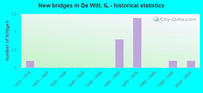
- New bridges - historical statistics
- 11910-1919
- 41960-1969
- 71970-1979
- 11990-1999
- 12000-2009
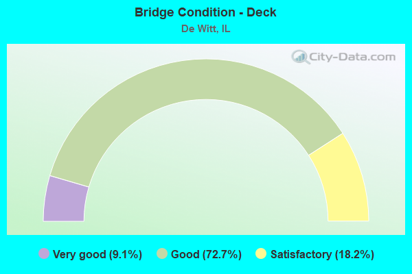
- Bridge Condition - Deck
- 9.1%Very good
- 72.7%Good
- 18.2%Satisfactory
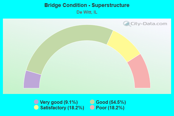
- Bridge Condition - Superstructure
- 9.1%Very good
- 54.5%Good
- 18.2%Satisfactory
- 18.2%Poor
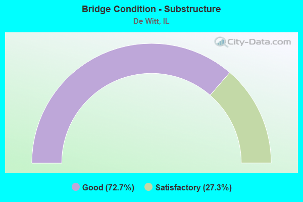
- Bridge Condition - Substructure
- 72.7%Good
- 27.3%Satisfactory
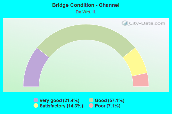
- Bridge Condition - Channel
- 21.4%Very good
- 57.1%Good
- 14.3%Satisfactory
- 7.1%Poor
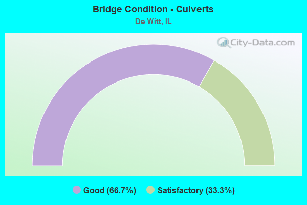
- Bridge Condition - Culverts
- 66.7%Good
- 33.3%Satisfactory
Find on map >> Show street view
Structure Number: 200043, Location: 3 MI W OF DEWITT (Lat: 40.179567, Lng: -88.844425), Route carried "on" structure: State highway 54, Year Built: 1976, Status: Open, Structure Length: 7.21m (23.65ft), Average Daily Traffic: 1,750 (year 2021), Truck Traffic: 15%, Average Future Daily Traffic: 2,200 (year 2032), Design Load: HS 20, Features Intersected: N FORK SALT CREEK
Minimum Vertical Clearance: 30+ m (98+ ft), Kilometerpoint: 77.311, Lanes on structure: 2, Base Highway Network: Yes, Owner: State Highway Agency, Approaching Roadway Width: 13.1m (43.0ft), Material/Design: Prestressed concrete continuous, Design/Construction: Stringer/Multi-beam, Number Of Spans In Main Unit: 3, Length of Maximum Span: 23.8m (78.1ft), Curb-To-Curb Width: 13.0m (42.7ft), Out-to-Out Width: 14.0m (45.9ft)
Condition: Deck: Good, Superstructure: Good, Substructure: Good, Channel: Very good, Operating Rating: 46.0 metric tons, Method Used To Determine Operating Rating: Load Factor (LF) rating reported by rating factor (RF) method using MS18 loading, Inventory Rating: 27.5 metric tons, Method Used To Determine Inventory Rating: Load Factor (LF) rating reported by rating factor (RF) method using MS18 loading, Structural Evaluation: Equal to present minimum criteria, Deck Geometry: Better than present minimum criteria, Waterway Adequacy: Equal to present desirable criteria, Approach Roadway Alignment: Equal to present desirable criteria, Designated Inspection Frequency: Every 24 months, Underwater Inspection Frequency: Every 60 months, Inspection Date: October 2021, Underwater Inspection Date: June 2021, Deck Structure Type: Concrete Cast-file-Place, Wearing Surface/Protective System: Wearing Surface: Bituminous, Membrane: Built-up
Find on map >> Show street view
Structure Number: 200044, Location: 3 MI W OF DEWITT (Lat: 40.180589, Lng: -88.841108), Route carried "on" structure: State highway 54, Year Built: 1976, Status: Open, Structure Length: 0.86m (2.82ft), Average Daily Traffic: 1,750 (year 2021), Truck Traffic: 15%, Average Future Daily Traffic: 2,200 (year 2032), Design Load: HS 20, Features Intersected: N FORK SALT CREEK
Minimum Vertical Clearance: 30+ m (98+ ft), Kilometerpoint: 77.617, Lanes on structure: 2, Base Highway Network: Yes, Owner: State Highway Agency, Approaching Roadway Width: 13.4m (44.0ft), Skew: 3 degrees, Material/Design: Concrete continuous, Design/Construction: Culvert, Number Of Spans In Main Unit: 2, Length of Maximum Span: 4.1m (13.5ft)
Condition: Channel: Very good, Culverts: Good, Operating Rating: 89.1 metric tons, Method Used To Determine Operating Rating: Allowable Stress (AS) rating reported by rating factor (RF) method using MS18 loading, Inventory Rating: 89.1 metric tons, Method Used To Determine Inventory Rating: Allowable Stress (AS) rating reported by rating factor (RF) method using MS18 loading, Structural Evaluation: Better than present minimum criteria, Waterway Adequacy: Equal to present desirable criteria, Approach Roadway Alignment: Equal to present desirable criteria, Designated Inspection Frequency: Every 48 months, Underwater Inspection Frequency: Every 60 months, Inspection Date: Febuary 2020, Underwater Inspection Date: October 2020
Find on map >> Show street view
Structure Number: 200045, Location: 4 MI N OF WELDON (Lat: 40.188781, Lng: -88.744864), Route carried "on" structure: State highway 48, Year Built: 1976, Status: Open, Structure Length: 7.00m (22.97ft), Average Daily Traffic: 1,000 (year 2021), Truck Traffic: 19%, Average Future Daily Traffic: 850 (year 2032), Design Load: HS 20, Features Intersected: CLINTON LAKE
Minimum Vertical Clearance: 30+ m (98+ ft), Kilometerpoint: 135.036, Lanes on structure: 2, Base Highway Network: Yes, Owner: State Highway Agency, Approaching Roadway Width: 9.8m (32.2ft), Material/Design: Prestressed concrete continuous, Design/Construction: Stringer/Multi-beam, Number Of Spans In Main Unit: 3, Length of Maximum Span: 24.3m (79.7ft), Curb-To-Curb Width: 13.0m (42.7ft), Out-to-Out Width: 14.0m (45.9ft)
Condition: Deck: Good, Superstructure: Poor, Substructure: Good, Channel: Very good, Operating Rating: 51.8 metric tons, Method Used To Determine Operating Rating: Load Factor (LF) rating reported by rating factor (RF) method using MS18 loading, Inventory Rating: 31.1 metric tons, Method Used To Determine Inventory Rating: Load Factor (LF) rating reported by rating factor (RF) method using MS18 loading, Structural Evaluation: Meets minimum limits, Deck Geometry: Superior to present desirable criteria, Waterway Adequacy: Equal to present desirable criteria, Approach Roadway Alignment: Equal to present desirable criteria, Designated Inspection Frequency: Every 12 months, Underwater Inspection Frequency: Every 60 months, Inspection Date: May 2021, Underwater Inspection Date: June 2021, Deck Structure Type: Concrete Cast-file-Place, Wearing Surface/Protective System: Wearing Surface: Bituminous, Membrane: Built-up
Find on map >> Show street view
Structure Number: 202012, Location: 0.25 MI NW JCT IL 48 (Lat: 40.212350, Lng: -88.739886), Route carried "on" structure: State highway 54, Year Built: 2002, Status: Open, Structure Length: 0.78m (2.56ft), Average Daily Traffic: 1,450 (year 2021), Truck Traffic: 17%, Average Future Daily Traffic: 1,650 (year 2032), Design Load: H 20, Features Intersected: CREEK
Minimum Vertical Clearance: 30+ m (98+ ft), Kilometerpoint: 87.160, Lanes on structure: 2, Base Highway Network: Yes, Owner: State Highway Agency, Approaching Roadway Width: 10.2m (33.5ft), Material/Design: Concrete continuous, Design/Construction: Culvert, Number Of Spans In Main Unit: 2, Length of Maximum Span: 3.8m (12.5ft)
Condition: Channel: Good, Culverts: Good, Operating Rating: 89.1 metric tons, Method Used To Determine Operating Rating: Load Factor (LF) rating reported by rating factor (RF) method using MS18 loading, Inventory Rating: 54.8 metric tons, Method Used To Determine Inventory Rating: Load Factor (LF) rating reported by rating factor (RF) method using MS18 loading, Structural Evaluation: Better than present minimum criteria, Waterway Adequacy: Equal to present desirable criteria, Approach Roadway Alignment: Equal to present desirable criteria, Designated Inspection Frequency: Every 48 months, Inspection Date: March 2019
Find on map >> Show street view
Structure Number: 203003, Location: 1 MI W PARNELL (Lat: 40.223953, Lng: -88.739953), Route carried "on" structure: County highway , Year Built: 1968, Status: Open, Structure Length: 0.91m (2.99ft), Average Daily Traffic: 350 (year 2018), Truck Traffic: 6%, Average Future Daily Traffic: 400 (year 2032), Design Load: HS 15, Features Intersected: STREAM, Facility Carried by Structure: CH 10 (FAS 543)
Minimum Vertical Clearance: 30+ m (98+ ft), Kilometerpoint: 19.521, Lanes on structure: 2, Owner: County Highway Agency, Approaching Roadway Width: 9.1m (29.9ft), Material/Design: Concrete, Design/Construction: Channel Beam, Number Of Spans In Main Unit: 1, Length of Maximum Span: 8.9m (29.2ft), Curb-To-Curb Width: 8.5m (27.9ft), Out-to-Out Width: 9.1m (29.9ft)
Condition: Deck: Satisfactory, Superstructure: Satisfactory, Substructure: Satisfactory, Channel: Satisfactory, Operating Rating: 59.6 metric tons, Method Used To Determine Operating Rating: Load Factor (LF) rating reported by rating factor (RF) method using MS18 loading, Inventory Rating: 35.6 metric tons, Method Used To Determine Inventory Rating: Load Factor (LF) rating reported by rating factor (RF) method using MS18 loading, Structural Evaluation: Equal to present minimum criteria, Deck Geometry: Equal to present minimum criteria, Waterway Adequacy: Better than present minimum criteria, Approach Roadway Alignment: Better than present minimum criteria, Designated Inspection Frequency: Every 24 months, Inspection Date: October 2020, Deck Structure Type: Concrete Precast Panels, Wearing Surface/Protective System: Wearing Surface: Bituminous
Find on map >> Show street view
Structure Number: 203045, Location: 1 MI SW PARNELL (Lat: 40.206925, Lng: -88.731367), Route carried "on" structure: County highway , Year Built: 1968, Status: Open, Structure Length: 1.89m (6.20ft), Average Daily Traffic: 50 (year 2020), Average Future Daily Traffic: 59 (year 2032), Design Load: HS 15, Features Intersected: SALT CREEK, Facility Carried by Structure: TR 103
Minimum Vertical Clearance: 30+ m (98+ ft), Kilometerpoint: 4.619, Lanes on structure: 2, Owner: Town or Township Highway Agency, Approaching Roadway Width: 7.3m (24.0ft), Material/Design: Prestressed concrete, Design/Construction: Box Beam or Girders - Multiple, Number Of Spans In Main Unit: 2, Length of Maximum Span: 9.8m (32.2ft), Curb-To-Curb Width: 6.1m (20.0ft), Out-to-Out Width: 6.7m (22.0ft)
Condition: Deck: Good, Superstructure: Good, Substructure: Good, Channel: Good, Operating Rating: 33.0 metric tons, Method Used To Determine Operating Rating: Load Factor (LF) rating reported by rating factor (RF) method using MS18 loading, Inventory Rating: 19.8 metric tons, Method Used To Determine Inventory Rating: Load Factor (LF) rating reported by rating factor (RF) method using MS18 loading, Structural Evaluation: Somewhat better than minimum adequacy, Deck Geometry: Somewhat better than minimum adequacy, Waterway Adequacy: Equal to present minimum criteria, Approach Roadway Alignment: Equal to present minimum criteria, Designated Inspection Frequency: Every 24 months, Inspection Date: January 2020, Deck Structure Type: Concrete Precast Panels, Wearing Surface/Protective System: Wearing Surface: Bituminous
Find on map >> Show street view
Structure Number: 203079, Location: 3.3 MI NW OF DEWITT (Lat: 40.223281, Lng: -88.821550), Route carried "on" structure: County highway , Year Built: 1911, Status: Posted for load, Structure Length: 3.17m (10.40ft), Average Daily Traffic: 100 (year 2018), Average Future Daily Traffic: 100 (year 2032), Features Intersected: N FORK SALT CREEK, Facility Carried by Structure: TR 188
Minimum Vertical Clearance: 4.11m (13.48ft), Kilometerpoint: 6.856, Lanes on structure: 1, Owner: Town or Township Highway Agency, Approaching Roadway Width: 4.3m (14.1ft), Material/Design: Steel, Design/Construction: Truss - Thru, Number Of Spans In Main Unit: 1, Length of Maximum Span: 30.5m (100.1ft), Curb-To-Curb Width: 4.3m (14.1ft), Out-to-Out Width: 4.3m (14.1ft)
Condition: Deck: Good, Superstructure: Poor, Substructure: Satisfactory, Channel: Good, Operating Rating: 18.5 metric tons, Method Used To Determine Operating Rating: Load Factor (LF) rating reported by rating factor (RF) method using MS18 loading, Inventory Rating: 11.0 metric tons, Method Used To Determine Inventory Rating: Load Factor (LF) rating reported by rating factor (RF) method using MS18 loading, Structural Evaluation: Meets minimum limits, Deck Geometry: Equal to present minimum criteria, Waterway Adequacy: Meets minimum limits, Approach Roadway Alignment: High priority of replacement, Bridge Posting: Required (Relationship of Operating Rating to Maximum Legal Load: > 39.9% below), Length Of Structure Improvement: 4.11m (13.48ft), Designated Inspection Frequency: Every 24 months, Critical Feature Inspection Frequency: Every 12 months, Inspection Date: Febuary 2020, Critical Feature Inspection Date: January 2021, Bridge Improvement Cost: $128,000, Roadway Improvement Cost: $13,000, Total Project Cost: $192,000, Deck Structure Type: Wood or Timber
Find on map >> Show street view
Structure Number: 20311, Location: 2.0 MI S DEWITT (Lat: 40.159681, Lng: -88.786247), Route carried "on" structure: County highway , Year Built: 1977, Status: Open, Structure Length: 8.41m (27.59ft), Average Daily Traffic: 750 (year 2018), Truck Traffic: 17%, Average Future Daily Traffic: 1,300 (year 2032), Design Load: HS 20+Mod, Features Intersected: STREAM, Facility Carried by Structure: FAS 1489(CH 14)
Minimum Vertical Clearance: 30+ m (98+ ft), Kilometerpoint: 7.515, Lanes on structure: 2, Owner: County Highway Agency, Approaching Roadway Width: 10.4m (34.1ft), Material/Design: Prestressed concrete, Design/Construction: Stringer/Multi-beam, Number Of Spans In Main Unit: 3, Length of Maximum Span: 27.7m (90.9ft), Curb-To-Curb Width: 8.1m (26.6ft), Out-to-Out Width: 9.1m (29.9ft)
Condition: Deck: Good, Superstructure: Good, Substructure: Good, Channel: Good, Operating Rating: 44.4 metric tons, Method Used To Determine Operating Rating: Assigned rating based on Load Factor Design (LFD) reported by rating factor (RF) using MS18 loading, Inventory Rating: 32.4 metric tons, Method Used To Determine Inventory Rating: Assigned rating based on Load Factor Design (LFD) reported by rating factor (RF) using MS18 loading, Structural Evaluation: Better than present minimum criteria, Deck Geometry: Somewhat better than minimum adequacy, Waterway Adequacy: Equal to present desirable criteria, Approach Roadway Alignment: Equal to present minimum criteria, Designated Inspection Frequency: Every 48 months, Inspection Date: July 2020, Deck Structure Type: Concrete Cast-file-Place, Wearing Surface/Protective System: Wearing Surface: Bituminous, Membrane: Built-up
Find on map >> Show street view
Structure Number: 203111, Location: 1.8 MI S DEWITT (Lat: 40.157622, Lng: -88.785203), Route carried "on" structure: County highway , Year Built: 1977, Status: Open, Structure Length: 4.69m (15.39ft), Average Daily Traffic: 750 (year 2018), Truck Traffic: 17%, Average Future Daily Traffic: 1,300 (year 2032), Design Load: HS 20, Features Intersected: STREAM, Facility Carried by Structure: FAS 1489(CH 14)
Minimum Vertical Clearance: 30+ m (98+ ft), Kilometerpoint: 7.757, Lanes on structure: 2, Owner: County Highway Agency, Approaching Roadway Width: 10.4m (34.1ft), Material/Design: Prestressed concrete, Design/Construction: Stringer/Multi-beam, Number Of Spans In Main Unit: 3, Length of Maximum Span: 15.5m (50.9ft), Curb-To-Curb Width: 8.1m (26.6ft), Out-to-Out Width: 9.1m (29.9ft)
Condition: Deck: Good, Superstructure: Good, Substructure: Good, Channel: Good, Operating Rating: 44.4 metric tons, Method Used To Determine Operating Rating: Assigned rating based on Load Factor Design (LFD) reported by rating factor (RF) using MS18 loading, Inventory Rating: 32.4 metric tons, Method Used To Determine Inventory Rating: Assigned rating based on Load Factor Design (LFD) reported by rating factor (RF) using MS18 loading, Structural Evaluation: Better than present minimum criteria, Deck Geometry: Somewhat better than minimum adequacy, Waterway Adequacy: Equal to present desirable criteria, Approach Roadway Alignment: Equal to present minimum criteria, Designated Inspection Frequency: Every 48 months, Inspection Date: July 2020, Deck Structure Type: Concrete Cast-file-Place, Wearing Surface/Protective System: Wearing Surface: Bituminous, Membrane: Built-up
Find on map >> Show street view
Structure Number: 203114, Location: 1 MI S OF DEWITT (Lat: 40.166947, Lng: -88.787800), Route carried "on" structure: County highway , Year Built: 1979, Status: Open, Structure Length: 7.80m (25.59ft), Average Daily Traffic: 750 (year 2018), Truck Traffic: 17%, Average Future Daily Traffic: 1,300 (year 2032), Design Load: HS 20, Features Intersected: IPC DISCHARGE FLUME, Facility Carried by Structure: CH 14 (FAS 1489)
Minimum Vertical Clearance: 30+ m (98+ ft), Kilometerpoint: 6.695, Lanes on structure: 2, Owner: County Highway Agency, Approaching Roadway Width: 10.4m (34.1ft), Material/Design: Prestressed concrete, Design/Construction: Stringer/Multi-beam, Number Of Spans In Main Unit: 3, Length of Maximum Span: 25.6m (84.0ft), Curb-To-Curb Width: 8.2m (26.9ft), Out-to-Out Width: 9.1m (29.9ft)
Condition: Deck: Satisfactory, Superstructure: Satisfactory, Substructure: Good, Channel: Good, Operating Rating: 44.4 metric tons, Method Used To Determine Operating Rating: Assigned rating based on Load Factor Design (LFD) reported by rating factor (RF) using MS18 loading, Inventory Rating: 32.4 metric tons, Method Used To Determine Inventory Rating: Assigned rating based on Load Factor Design (LFD) reported by rating factor (RF) using MS18 loading, Structural Evaluation: Equal to present minimum criteria, Deck Geometry: Somewhat better than minimum adequacy, Waterway Adequacy: Superior to present desirable criteria, Approach Roadway Alignment: Better than present minimum criteria, Designated Inspection Frequency: Every 24 months, Inspection Date: May 2020, Deck Structure Type: Concrete Cast-file-Place, Wearing Surface/Protective System: Wearing Surface: Bituminous, Membrane: Built-up
Find on map >> Show street view
Structure Number: 203116, Location: 1 MI NE OF BIRKBECK (Lat: 40.189917, Lng: -88.846139), Route carried "on" structure: County highway , Year Built: 1978, Status: Open, Structure Length: 4.88m (16.01ft), Average Daily Traffic: 375 (year 2018), Truck Traffic: 2%, Average Future Daily Traffic: 150 (year 2032), Design Load: HS 20, Features Intersected: CLINTON LAKE, Facility Carried by Structure: TR 119
Minimum Vertical Clearance: 30+ m (98+ ft), Kilometerpoint: 1.448, Lanes on structure: 2, Owner: Town or Township Highway Agency, Approaching Roadway Width: 7.3m (24.0ft), Material/Design: Prestressed concrete, Design/Construction: Box Beam or Girders - Multiple, Number Of Spans In Main Unit: 3, Length of Maximum Span: 16.2m (53.1ft), Curb-To-Curb Width: 7.3m (24.0ft), Out-to-Out Width: 7.5m (24.6ft)
Condition: Deck: Good, Superstructure: Good, Substructure: Satisfactory, Channel: Satisfactory, Operating Rating: 44.4 metric tons, Method Used To Determine Operating Rating: Assigned rating based on Load Factor Design (LFD) reported by rating factor (RF) using MS18 loading, Inventory Rating: 32.4 metric tons, Method Used To Determine Inventory Rating: Assigned rating based on Load Factor Design (LFD) reported by rating factor (RF) using MS18 loading, Structural Evaluation: Equal to present minimum criteria, Deck Geometry: Somewhat better than minimum adequacy, Waterway Adequacy: Superior to present desirable criteria, Approach Roadway Alignment: Equal to present minimum criteria, Designated Inspection Frequency: Every 24 months, Inspection Date: January 2020, Deck Structure Type: Concrete Precast Panels, Wearing Surface/Protective System: Wearing Surface: Bituminous
Find on map >> Show street view
Structure Number: 203168, Location: 9 MI W FARMER CITY (Lat: 40.235919, Lng: -88.809500), Route carried "on" structure: County highway , Year Built: 1991, Status: Open, Structure Length: 4.19m (13.75ft), Average Daily Traffic: 75 (year 2018), Average Future Daily Traffic: 75 (year 2032), Design Load: HS 20, Features Intersected: N FORK SALT CREEK, Facility Carried by Structure: TR 65
Minimum Vertical Clearance: 30+ m (98+ ft), Kilometerpoint: 9.447, Lanes on structure: 2, Owner: Town or Township Highway Agency, Approaching Roadway Width: 4.9m (16.1ft), Material/Design: Prestressed concrete, Design/Construction: Box Beam or Girders - Multiple, Number Of Spans In Main Unit: 3, Length of Maximum Span: 15.8m (51.8ft), Curb-To-Curb Width: 7.3m (24.0ft), Out-to-Out Width: 7.3m (24.0ft)
Condition: Deck: Good, Superstructure: Good, Substructure: Good, Channel: Good, Operating Rating: 44.4 metric tons, Method Used To Determine Operating Rating: Assigned rating based on Load Factor Design (LFD) reported by rating factor (RF) using MS18 loading, Inventory Rating: 32.4 metric tons, Method Used To Determine Inventory Rating: Assigned rating based on Load Factor Design (LFD) reported by rating factor (RF) using MS18 loading, Structural Evaluation: Better than present minimum criteria, Deck Geometry: Equal to present minimum criteria, Waterway Adequacy: Equal to present minimum criteria, Approach Roadway Alignment: Equal to present desirable criteria, Designated Inspection Frequency: Every 48 months, Inspection Date: May 2020, Deck Structure Type: Concrete Precast Panels
Find on map >> Show street view
Structure Number: 2039, Location: 7 MI E OF WAPELLA (Lat: 40.224450, Lng: -88.820969), Route carried "on" structure: County highway , Year Built: 1969, Year Reconstructed: 2010, Status: Open, Structure Length: 7.13m (23.39ft), Average Daily Traffic: 500 (year 2018), Truck Traffic: 10%, Average Future Daily Traffic: 500 (year 2032), Design Load: HS 25 or greater, Features Intersected: N FORK SALT CREEK, Facility Carried by Structure: CH 10(FAS 543)
Minimum Vertical Clearance: 30+ m (98+ ft), Kilometerpoint: 12.601, Lanes on structure: 2, Owner: County Highway Agency, Approaching Roadway Width: 10.4m (34.1ft), Skew: 1 degrees, Material/Design: Prestressed concrete, Design/Construction: Box Beam or Girders - Multiple, Number Of Spans In Main Unit: 4, Length of Maximum Span: 17.7m (58.1ft), Curb-To-Curb Width: 8.1m (26.6ft), Out-to-Out Width: 9.1m (29.9ft)
Condition: Deck: Very good, Superstructure: Very good, Substructure: Good, Channel: Good, Operating Rating: 44.4 metric tons, Method Used To Determine Operating Rating: Load and Resistance Factor Rating (LRFR) rating reported by rating factor(RF) method using HL-93 loadings, Inventory Rating: 34.3 metric tons, Method Used To Determine Inventory Rating: Load and Resistance Factor Rating (LRFR) rating reported by rating factor(RF) method using HL-93 loadings, Structural Evaluation: Better than present minimum criteria, Deck Geometry: Somewhat better than minimum adequacy, Waterway Adequacy: Equal to present desirable criteria, Approach Roadway Alignment: Better than present minimum criteria, Designated Inspection Frequency: Every 48 months, Inspection Date: July 2020, Deck Structure Type: Concrete Precast Panels, Wearing Surface/Protective System: Wearing Surface: Integral Concrete, Deck Protection: Epoxy Coated Reinforcing
Find on map >> Show street view
Structure Number: 205007, Location: 2 MI E OF BIRKBECK (Lat: 40.185928, Lng: -88.832189), Route carried "on" structure: County highway , Year Built: 1968, Status: Open, Structure Length: 0.82m (2.69ft), Average Daily Traffic: 375 (year 2018), Truck Traffic: 2%, Average Future Daily Traffic: 150 (year 2032), Design Load: HS 15, Features Intersected: STREAM, Facility Carried by Structure: TR 119
Minimum Vertical Clearance: 30+ m (98+ ft), Kilometerpoint: 3.009, Lanes on structure: 2, Owner: Town or Township Highway Agency, Approaching Roadway Width: 6.1m (20.0ft), Material/Design: Steel, Design/Construction: Culvert, Number Of Spans In Main Unit: 2, Length of Maximum Span: 3.7m (12.1ft)
Condition: Channel: Poor, Culverts: Satisfactory, Operating Rating: 40.5 metric tons, Method Used To Determine Operating Rating: Field evaluation and documented engineering judgment, Inventory Rating: 24.3 metric tons, Method Used To Determine Inventory Rating: Field evaluation and documented engineering judgment, Structural Evaluation: Equal to present minimum criteria, Waterway Adequacy: Equal to present minimum criteria, Approach Roadway Alignment: Equal to present minimum criteria, Designated Inspection Frequency: Every 24 months, Inspection Date: January 2020