Bridge Statistics for De Witt, Michigan (MI)
Condition, Traffic, Stress, Structural Evaluation, Project Costs
- National Bridge Inventory (NBI) Statistics
- 20Number of bridges
- 243ft / 74.5mTotal length
- $63,000Total costs
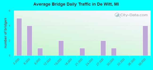
- 311,864Total average daily traffic
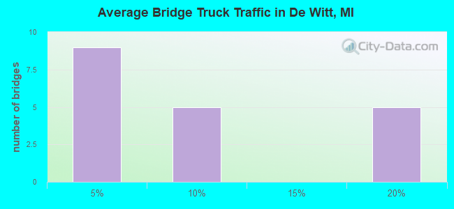
- 36,677Total average daily truck traffic
- National Bridge Inventory (NBI) Registered Bridges for De Witt
- No street view available for this location
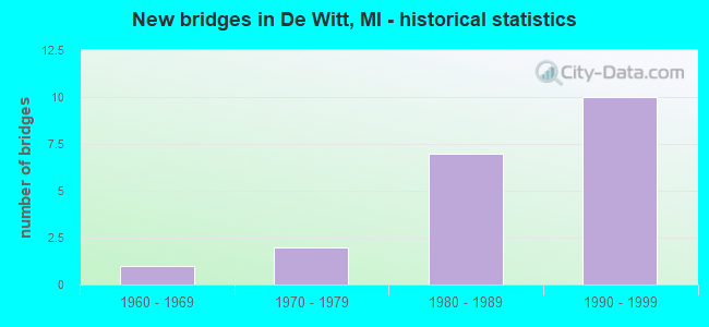
- New bridges - historical statistics
- 11960-1969
- 21970-1979
- 71980-1989
- 101990-1999
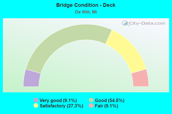
- Bridge Condition - Deck
- 9.1%Very good
- 54.5%Good
- 27.3%Satisfactory
- 9.1%Fair
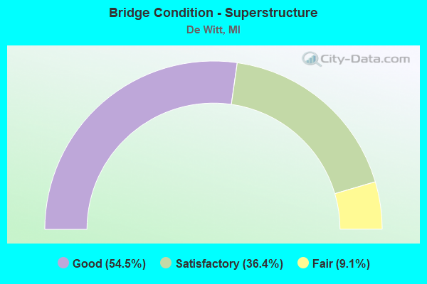
- Bridge Condition - Superstructure
- 54.5%Good
- 36.4%Satisfactory
- 9.1%Fair
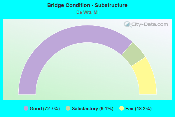
- Bridge Condition - Substructure
- 72.7%Good
- 9.1%Satisfactory
- 18.2%Fair
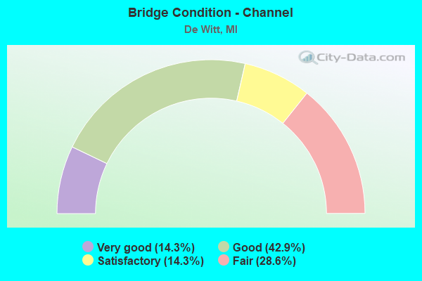
- Bridge Condition - Channel
- 14.3%Very good
- 42.9%Good
- 14.3%Satisfactory
- 28.6%Fair
Find on map >> Show street view
Structure Number: 1859, Location: 0.1 MILE NW OF WOOD ST (Lat: 42.817736, Lng: -84.527847), Route carried "on" structure: Interstate 69, Year Built: 1973, Status: Open, Structure Length: 0.73m (2.40ft), Average Daily Traffic: 37,978 (year 2007), Truck Traffic: 16%, Average Future Daily Traffic: 49,205 (year 2018), Design Load: HS 20+Mod, Features Intersected: CHANDLER DRAIN
Minimum Vertical Clearance: 30.48m (100.00ft), Kilometerpoint: 13.570, Lanes on structure: 6, Base Highway Network: Yes (Inventory Route: 36, Subroute: 5), Owner: State Highway Agency, Approaching Roadway Width: 11.0m (36.1ft), Material/Design: Steel, Design/Construction: Culvert, Number Of Spans In Main Unit: 2, Length of Maximum Span: 3.6m (11.8ft), Curb-To-Curb Width: 28.0m (91.9ft), Out-to-Out Width: 80.5m (264.1ft)
Condition: Channel: Fair, Culverts: Fair, Operating Rating: 97.2 metric tons, Method Used To Determine Operating Rating: Load Factor (LF) rating reported by rating factor (RF) method using MS18 loading, Inventory Rating: 97.2 metric tons, Method Used To Determine Inventory Rating: Load Factor (LF) rating reported by rating factor (RF) method using MS18 loading, Structural Evaluation: Somewhat better than minimum adequacy, Deck Geometry: Equal to present minimum criteria, Waterway Adequacy: Equal to present minimum criteria, Approach Roadway Alignment: Equal to present desirable criteria, Designated Inspection Frequency: Every 24 months, Inspection Date: April 2020
Find on map >> Show street view
Structure Number: 187, Location: 0.75 MI SE OF DEWITT (Lat: 42.813278, Lng: -84.581100), Route carried "on" structure: County highway , Year Built: 1980, Status: Open, Structure Length: 12.31m (40.39ft), Average Daily Traffic: 450 (year 1984), Truck Traffic: 4%, Average Future Daily Traffic: 4,000 (year 2015), Design Load: HS 25 or greater, Features Intersected: I-69, Facility Carried by Structure: CLARK RD
Minimum Vertical Clearance: 30.48m (100.00ft), Kilometerpoint: 22.139, Lanes on structure: 2, Lanes under structure: 4, Owner: State Highway Agency, Approaching Roadway Width: 13.7m (44.9ft), Skew: 4 degrees, Material/Design: Steel, Design/Construction: Stringer/Multi-beam, Number Of Spans In Main Unit: 4, Length of Maximum Span: 49.3m (161.7ft), Curb-To-Curb Width: 12.9m (42.3ft), Out-to-Out Width: 13.6m (44.6ft)
Condition: Deck: Satisfactory, Superstructure: Fair, Substructure: Satisfactory, Operating Rating: 78.1 metric tons, Method Used To Determine Operating Rating: Load Factor (LF) rating reported by rating factor (RF) method using MS18 loading, Inventory Rating: 46.7 metric tons, Method Used To Determine Inventory Rating: Load Factor (LF) rating reported by rating factor (RF) method using MS18 loading, Structural Evaluation: Somewhat better than minimum adequacy, Deck Geometry: Superior to present desirable criteria, Underclear: Superior to present desirable criteria, Approach Roadway Alignment: Equal to present desirable criteria, Designated Inspection Frequency: Every 24 months, Inspection Date: April 2020, Deck Structure Type: Concrete Cast-file-Place, Wearing Surface/Protective System: Wearing Surface: Latex Concrete, Deck Protection: Epoxy Coated Reinforcing
Find on map >> Show street view
Structure Number: 188, Location: 1.2 MI S OF DEWITT (Lat: 42.817208, Lng: -84.560839), Route carried "on" structure: Interstate 69, Year Built: 1980, Status: Open, Structure Length: 3.44m (11.29ft), Average Daily Traffic: 18,999 (year 2007), Truck Traffic: 17%, Average Future Daily Traffic: 25,598 (year 2018), Design Load: HS 25 or greater, Features Intersected: TURNER RD
Minimum Vertical Clearance: 30.48m (100.00ft), Kilometerpoint: 10.894, Lanes on structure: 2, Lanes under structure: 2, Base Highway Network: Yes (Inventory Route: 36, Subroute: 5), Owner: State Highway Agency, Approaching Roadway Width: 12.8m (42.0ft), Skew: 3 degrees, Material/Design: Steel, Design/Construction: Stringer/Multi-beam, Number Of Spans In Main Unit: 1, Length of Maximum Span: 34.4m (112.9ft), Curb-To-Curb Width: 12.5m (41.0ft), Out-to-Out Width: 13.8m (45.3ft)
Condition: Deck: Fair, Superstructure: Satisfactory, Substructure: Fair, Operating Rating: 88.1 metric tons, Method Used To Determine Operating Rating: Load Factor (LF) rating reported by rating factor (RF) method using MS18 loading, Inventory Rating: 52.8 metric tons, Method Used To Determine Inventory Rating: Load Factor (LF) rating reported by rating factor (RF) method using MS18 loading, Structural Evaluation: Somewhat better than minimum adequacy, Deck Geometry: Better than present minimum criteria, Underclear: Meets minimum limits, Approach Roadway Alignment: Equal to present desirable criteria, Designated Inspection Frequency: Every 24 months, Inspection Date: April 2020, Deck Structure Type: Concrete Cast-file-Place, Wearing Surface/Protective System: Wearing Surface: Epoxy Overlay, Membrane: Epoxy, Deck Protection: Epoxy Coated Reinforcing
Find on map >> Show street view
Structure Number: 1928, Location: BETWEEN HERBISON RDS (Lat: 42.824736, Lng: -84.602683), Route carried "on" structure: County highway 1949, Year Built: 1993, Status: Open, Structure Length: 3.41m (11.19ft), Average Daily Traffic: 4,115 (year 2011), Truck Traffic: 2%, Average Future Daily Traffic: 7,432 (year 2031), Design Load: HS 20, Features Intersected: LOOKING GLASS RIVER, Facility Carried by Structure: AIRPORT ROAD
Minimum Vertical Clearance: 30.48m (100.00ft), Kilometerpoint: 6.016, Lanes on structure: 2, Owner: County Highway Agency, Approaching Roadway Width: 10.4m (34.1ft), Skew: 4 degrees, Material/Design: Prestressed concrete, Design/Construction: Box Beam or Girders - Multiple, Number Of Spans In Main Unit: 1, Length of Maximum Span: 32.0m (105.0ft), Curb or Sidewalk Widths: Left: 1.5m (4.9ft), Right: 1.5m (4.9ft), Curb-To-Curb Width: 10.1m (33.1ft), Out-to-Out Width: 15.1m (49.5ft)
Condition: Deck: Very good, Superstructure: Good, Substructure: Good, Channel: Satisfactory, Operating Rating: 97.4 metric tons, Method Used To Determine Operating Rating: Load Factor (LF), Inventory Rating: 58.4 metric tons, Method Used To Determine Inventory Rating: Load Factor (LF), Structural Evaluation: Better than present minimum criteria, Deck Geometry: Meets minimum limits, Waterway Adequacy: Equal to present minimum criteria, Approach Roadway Alignment: Equal to present desirable criteria, Designated Inspection Frequency: Every 24 months, Inspection Date: October 2020, Deck Structure Type: Concrete Cast-file-Place, Wearing Surface/Protective System: Wearing Surface: Monolithic Concrete, Deck Protection: Epoxy Coated Reinforcing
Find on map >> Show street view
Structure Number: 1933, Location: 1/4 MI S OF ROUND LAKE (Lat: 42.853733, Lng: -84.523167), Route carried "on" structure: County highway 1969, Year Built: 1964, Status: Open, Structure Length: 3.84m (12.60ft), Average Daily Traffic: 1,632 (year 2013), Truck Traffic: 1%, Average Future Daily Traffic: 1,992 (year 2033), Design Load: HS 20, Features Intersected: LOOKING GLASS RIVER, Facility Carried by Structure: WOOD ROAD
Minimum Vertical Clearance: 30.48m (100.00ft), Kilometerpoint: 10.360, Lanes on structure: 2, Owner: County Highway Agency, Approaching Roadway Width: 9.1m (29.9ft), Skew: 1 degrees, Material/Design: Prestressed concrete, Design/Construction: Box Beam or Girders - Multiple, Number Of Spans In Main Unit: 3, Length of Maximum Span: 12.8m (42.0ft), Curb or Sidewalk Widths: Left: 0.2m (0.7ft), Right: 0.2m (0.7ft), Curb-To-Curb Width: 7.9m (25.9ft), Out-to-Out Width: 9.4m (30.8ft)
Condition: Deck: Good, Superstructure: Good, Substructure: Good, Channel: Fair, Operating Rating: 62.1 metric tons, Method Used To Determine Operating Rating: Load Factor (LF), Inventory Rating: 37.2 metric tons, Method Used To Determine Inventory Rating: Load Factor (LF), Structural Evaluation: Better than present minimum criteria, Deck Geometry: Meets minimum limits, Waterway Adequacy: Equal to present minimum criteria, Approach Roadway Alignment: Better than present minimum criteria, Length Of Structure Improvement: 3.84m (12.60ft), Designated Inspection Frequency: Every 24 months, Inspection Date: October 2020, Bridge Improvement Cost: $53,000, Total Project Cost: $63,000, Deck Structure Type: Concrete Precast Panels, Wearing Surface/Protective System: Wearing Surface: Bituminous, Membrane: Preformed Fabric
Find on map >> Show street view
Structure Number: 2026, Location: 0.8 MI N OF S CITY LIMITS (Lat: 42.839903, Lng: -84.569131), Route carried "on" structure: City street 1959, Year Built: 1993, Status: Open, Structure Length: 2.37m (7.78ft), Average Daily Traffic: 3,900 (year 2006), Truck Traffic: 2%, Average Future Daily Traffic: 4,700 (year 2026), Design Load: HS 20, Features Intersected: LOOKING GLASS RIVER, Facility Carried by Structure: BRIDGE STREET
Minimum Vertical Clearance: 30.48m (100.00ft), Kilometerpoint: 4.645, Lanes on structure: 2, Owner: City or Municipal Highway Agency, Approaching Roadway Width: 10.7m (35.1ft), Material/Design: Prestressed concrete, Design/Construction: Box Beam or Girders - Multiple, Number Of Spans In Main Unit: 2, Length of Maximum Span: 11.8m (38.7ft), Curb or Sidewalk Widths: Left: 1.5m (4.9ft), Right: 1.7m (5.6ft), Curb-To-Curb Width: 10.7m (35.1ft), Out-to-Out Width: 15.1m (49.5ft)
Condition: Deck: Satisfactory, Superstructure: Good, Substructure: Good, Channel: Very good, Operating Rating: 94.6 metric tons, Method Used To Determine Operating Rating: Load Factor (LF) rating reported by rating factor (RF) method using MS18 loading, Inventory Rating: 56.7 metric tons, Method Used To Determine Inventory Rating: Load Factor (LF) rating reported by rating factor (RF) method using MS18 loading, Structural Evaluation: Better than present minimum criteria, Deck Geometry: Somewhat better than minimum adequacy, Waterway Adequacy: Equal to present desirable criteria, Approach Roadway Alignment: Equal to present desirable criteria, Designated Inspection Frequency: Every 24 months, Inspection Date: October 2020, Deck Structure Type: Concrete Precast Panels, Wearing Surface/Protective System: Wearing Surface: Integral Concrete, Deck Protection: Epoxy Coated Reinforcing
Find on map >> Show street view
Structure Number: 2027, Location: N CITY LIMITS OF DEWITT (Lat: 42.842067, Lng: -84.588692), Route carried "on" structure: City street , Year Built: 1981, Status: Open, Structure Length: 2.62m (8.60ft), Average Daily Traffic: 2,500 (year 2006), Truck Traffic: 2%, Average Future Daily Traffic: 3,700 (year 2026), Design Load: HS 20, Features Intersected: LOOKING GLASS RIVER, Facility Carried by Structure: SCHAVEY ROAD
Minimum Vertical Clearance: 30.48m (100.00ft), Kilometerpoint: 3.201, Lanes on structure: 2, Owner: City or Municipal Highway Agency, Approaching Roadway Width: 9.4m (30.8ft), Skew: 2 degrees, Material/Design: Prestressed concrete, Design/Construction: Box Beam or Girders - Multiple, Number Of Spans In Main Unit: 2, Length of Maximum Span: 13.1m (43.0ft), Curb or Sidewalk Widths: Left: 1.5m (4.9ft), Right: 1.5m (4.9ft), Curb-To-Curb Width: 9.4m (30.8ft), Out-to-Out Width: 13.4m (44.0ft)
Condition: Deck: Good, Superstructure: Good, Substructure: Fair, Channel: Good, Operating Rating: 48.3 metric tons, Method Used To Determine Operating Rating: Load Factor (LF) rating reported by rating factor (RF) method using MS18 loading, Inventory Rating: 28.8 metric tons, Method Used To Determine Inventory Rating: Load Factor (LF) rating reported by rating factor (RF) method using MS18 loading, Structural Evaluation: Somewhat better than minimum adequacy, Deck Geometry: Meets minimum limits, Waterway Adequacy: Equal to present desirable criteria, Approach Roadway Alignment: Equal to present desirable criteria, Designated Inspection Frequency: Every 24 months, Inspection Date: October 2020, Deck Structure Type: Concrete Precast Panels, Wearing Surface/Protective System: Wearing Surface: Bituminous, Deck Protection: Epoxy Coated Reinforcing
Find on map >> Show street view
Structure Number: 12672, Location: 1.2 M N LOOKING GLASS RIV (Lat: 42.870992, Lng: -84.517775), Route carried "on" structure: County highway , Year Built: 1996, Status: Open, Structure Length: 8.87m (29.10ft), Average Daily Traffic: 800 (year 1996), Truck Traffic: 3%, Average Future Daily Traffic: 800 (year 2015), Design Load: HS 20, Features Intersected: US-127, Facility Carried by Structure: CHADWICK ROAD
Minimum Vertical Clearance: 30.48m (100.00ft), Kilometerpoint: 19.710, Lanes on structure: 2, Lanes under structure: 4, Owner: State Highway Agency, Approaching Roadway Width: 10.3m (33.8ft), Skew: 1 degrees, Material/Design: Prestressed concrete, Design/Construction: Stringer/Multi-beam, Number Of Spans In Main Unit: 4, Length of Maximum Span: 33.1m (108.6ft), Curb-To-Curb Width: 11.6m (38.1ft), Out-to-Out Width: 12.5m (41.0ft)
Condition: Deck: Good, Superstructure: Good, Substructure: Good, Operating Rating: 85.2 metric tons, Method Used To Determine Operating Rating: Load Factor (LF) rating reported by rating factor (RF) method using MS18 loading, Inventory Rating: 41.1 metric tons, Method Used To Determine Inventory Rating: Load Factor (LF) rating reported by rating factor (RF) method using MS18 loading, Structural Evaluation: Better than present minimum criteria, Deck Geometry: Better than present minimum criteria, Underclear: Better than present minimum criteria, Approach Roadway Alignment: Equal to present desirable criteria, Designated Inspection Frequency: Every 24 months, Inspection Date: May 2020, Deck Structure Type: Concrete Cast-file-Place, Wearing Surface/Protective System: Wearing Surface: Monolithic Concrete, Deck Protection: Epoxy Coated Reinforcing
Find on map >> Show street view
Structure Number: 12673, Location: 1 MI S OF GREEN ROAD (Lat: 42.892717, Lng: -84.517283), Route carried "on" structure: County highway , Year Built: 1996, Status: Open, Structure Length: 8.70m (28.54ft), Average Daily Traffic: 2,700 (year 1995), Truck Traffic: 3%, Average Future Daily Traffic: 3,050 (year 2015), Design Load: HS 20, Features Intersected: US-127, Facility Carried by Structure: ALWARD ROAD
Minimum Vertical Clearance: 30.48m (100.00ft), Kilometerpoint: 4.490, Lanes on structure: 2, Lanes under structure: 4, Owner: State Highway Agency, Approaching Roadway Width: 14.0m (45.9ft), Material/Design: Prestressed concrete, Design/Construction: Stringer/Multi-beam, Number Of Spans In Main Unit: 4, Length of Maximum Span: 32.5m (106.6ft), Curb-To-Curb Width: 13.4m (44.0ft), Out-to-Out Width: 14.4m (47.2ft)
Condition: Deck: Good, Superstructure: Satisfactory, Substructure: Good, Operating Rating: 73.9 metric tons, Method Used To Determine Operating Rating: Load Factor (LF) rating reported by rating factor (RF) method using MS18 loading, Inventory Rating: 38.9 metric tons, Method Used To Determine Inventory Rating: Load Factor (LF) rating reported by rating factor (RF) method using MS18 loading, Structural Evaluation: Equal to present minimum criteria, Deck Geometry: Better than present minimum criteria, Underclear: Superior to present desirable criteria, Approach Roadway Alignment: Equal to present desirable criteria, Designated Inspection Frequency: Every 24 months, Inspection Date: May 2020, Deck Structure Type: Concrete Cast-file-Place, Wearing Surface/Protective System: Wearing Surface: Monolithic Concrete, Deck Protection: Epoxy Coated Reinforcing
Find on map >> Show street view
Structure Number: 12693, Location: DEWITT TWP SEC 2 (Lat: 42.854508, Lng: -84.518992), Route carried "on" structure: US 127, Year Built: 1997, Status: Open, Structure Length: 9.28m (30.45ft), Average Daily Traffic: 14,359 (year 2007), Truck Traffic: 8%, Average Future Daily Traffic: 18,793 (year 2018), Design Load: HS 25 or greater, Features Intersected: LOOKING GLASS RIVER
Minimum Vertical Clearance: 30.48m (100.00ft), Kilometerpoint: 9.569, Lanes on structure: 3, Base Highway Network: Yes (Inventory Route: 36, Subroute: 3), Owner: State Highway Agency, Approaching Roadway Width: 17.4m (57.1ft), Skew: 1 degrees, Material/Design: Prestressed concrete, Design/Construction: Stringer/Multi-beam, Number Of Spans In Main Unit: 3, Length of Maximum Span: 30.9m (101.4ft), Curb-To-Curb Width: 17.1m (56.1ft), Out-to-Out Width: 18.1m (59.4ft)
Condition: Deck: Good, Superstructure: Good, Substructure: Good, Channel: Good, Operating Rating: 73.2 metric tons, Method Used To Determine Operating Rating: Load Factor (LF) rating reported by rating factor (RF) method using MS18 loading, Inventory Rating: 32.4 metric tons, Method Used To Determine Inventory Rating: Load Factor (LF) rating reported by rating factor (RF) method using MS18 loading, Structural Evaluation: Better than present minimum criteria, Deck Geometry: Superior to present desirable criteria, Waterway Adequacy: Equal to present desirable criteria, Approach Roadway Alignment: Equal to present desirable criteria, Designated Inspection Frequency: Every 24 months, Inspection Date: May 2020, Deck Structure Type: Concrete Cast-file-Place, Wearing Surface/Protective System: Wearing Surface: Epoxy Overlay, Deck Protection: Epoxy Coated Reinforcing
Find on map >> Show street view
Structure Number: 12694, Location: DEWITT TWP SEC 2 (Lat: 42.854658, Lng: -84.518483), Route carried "on" structure: US 127, Year Built: 1997, Status: Open, Structure Length: 9.28m (30.45ft), Average Daily Traffic: 14,359 (year 2007), Truck Traffic: 8%, Average Future Daily Traffic: 18,793 (year 2018), Design Load: HS 25 or greater, Features Intersected: LOOKING GLASS RIVER
Minimum Vertical Clearance: 30.48m (100.00ft), Kilometerpoint: 9.558, Lanes on structure: 3, Base Highway Network: Yes (Inventory Route: 36, Subroute: 10), Owner: State Highway Agency, Approaching Roadway Width: 17.1m (56.1ft), Skew: 1 degrees, Material/Design: Prestressed concrete, Design/Construction: Stringer/Multi-beam, Number Of Spans In Main Unit: 3, Length of Maximum Span: 30.9m (101.4ft), Curb-To-Curb Width: 17.1m (56.1ft), Out-to-Out Width: 18.1m (59.4ft)
Condition: Deck: Good, Superstructure: Satisfactory, Substructure: Good, Channel: Good, Operating Rating: 64.9 metric tons, Method Used To Determine Operating Rating: Load Factor (LF), Inventory Rating: 24.3 metric tons, Method Used To Determine Inventory Rating: Load Factor (LF), Structural Evaluation: Equal to present minimum criteria, Deck Geometry: Superior to present desirable criteria, Waterway Adequacy: Equal to present desirable criteria, Approach Roadway Alignment: Equal to present desirable criteria, Designated Inspection Frequency: Every 24 months, Inspection Date: May 2020, Deck Structure Type: Concrete Cast-file-Place, Wearing Surface/Protective System: Wearing Surface: Monolithic Concrete, Deck Protection: Epoxy Coated Reinforcing
Find on map >> Show street view
Structure Number: 127, Location: 0.1 M N LOOKING GLASS RIV (Lat: 42.856500, Lng: -84.518486), Route carried "on" structure: County highway , Year Built: 1997, Status: Open, Structure Length: 9.63m (31.59ft), Average Daily Traffic: 6,500 (year 1997), Truck Traffic: 3%, Average Future Daily Traffic: 6,500 (year 2017), Design Load: HS 20+Mod, Features Intersected: US-127, Facility Carried by Structure: ROUND LAKE ROAD
Minimum Vertical Clearance: 30.48m (100.00ft), Kilometerpoint: 26.656, Lanes on structure: 2, Lanes under structure: 6, Owner: State Highway Agency, Approaching Roadway Width: 14.6m (47.9ft), Material/Design: Prestressed concrete, Design/Construction: Box Beam or Girders - Multiple, Number Of Spans In Main Unit: 4, Length of Maximum Span: 37.6m (123.4ft), Curb-To-Curb Width: 14.6m (47.9ft), Out-to-Out Width: 15.6m (51.2ft)
Condition: Deck: Satisfactory, Superstructure: Satisfactory, Substructure: Good, Operating Rating: 97.2 metric tons, Method Used To Determine Operating Rating: Load Factor (LF) rating reported by rating factor (RF) method using MS18 loading, Inventory Rating: 34.3 metric tons, Method Used To Determine Inventory Rating: Load Factor (LF) rating reported by rating factor (RF) method using MS18 loading, Structural Evaluation: Equal to present minimum criteria, Deck Geometry: Superior to present desirable criteria, Underclear: Better than present minimum criteria, Approach Roadway Alignment: Equal to present desirable criteria, Designated Inspection Frequency: Every 24 months, Inspection Date: May 2020, Deck Structure Type: Concrete Cast-file-Place, Wearing Surface/Protective System: Wearing Surface: Monolithic Concrete, Deck Protection: Epoxy Coated Reinforcing
Find on map >> Show street view
Structure Number: 1867, Location: AT N LTS OF LANSING (Lat: 42.817750, Lng: -84.542783), Route carried "under" structure: Interstate 69, Year Built: 1971, Structure Length: 0. m, Average Daily Traffic: 37,998 (year 2007), Truck Traffic: 16%, Features Intersected: I-69, Facility Carried by Structure: US-127 BR
Minimum Vertical Clearance: 4.90m (16.08ft), Kilometerpoint: 12.349, Lanes on structure: 6, Lanes under structure: 6, Material/Design: Steel, Design/Construction: Stringer/Multi-beam, Length of Maximum Span: 38.8m (127.3ft)
Find on map >> Show street view
Structure Number: 1868, Location: 1.2 MI S OF DEWITT (Lat: 42.816886, Lng: -84.560556), Route carried "under" structure: County highway , Year Built: 1980, Structure Length: 0. m, Average Daily Traffic: 3,518 (year 1984), Truck Traffic: 4%, Features Intersected: TURNER RD, Facility Carried by Structure: I-69 WB
Minimum Vertical Clearance: 4.70m (15.42ft), Kilometerpoint: 5.425, Lanes on structure: 2, Lanes under structure: 2, Material/Design: Steel, Design/Construction: Stringer/Multi-beam, Length of Maximum Span: 34.4m (112.9ft)
Find on map >> Show street view
Structure Number: 1869, Location: 0.6 MI SE OF DEWITT (Lat: 42.816203, Lng: -84.572372), Route carried "under" structure: Interstate 69, Year Built: 1980, Structure Length: 0. m, Average Daily Traffic: 37,998 (year 2007), Truck Traffic: 17%, Features Intersected: I-69, Facility Carried by Structure: DEWITT RD
Minimum Vertical Clearance: 5.03m (16.50ft), Kilometerpoint: 9.925, Lanes on structure: 5, Lanes under structure: 5, Material/Design: Steel continuous, Design/Construction: Stringer/Multi-beam, Length of Maximum Span: 39.3m (128.9ft)
Find on map >> Show street view
Structure Number: 187, Location: 0.75 MI SE OF DEWITT (Lat: 42.813278, Lng: -84.581100), Route carried "under" structure: Interstate 69, Year Built: 1980, Structure Length: 0. m, Average Daily Traffic: 37,978 (year 2007), Truck Traffic: 16%, Features Intersected: I-69, Facility Carried by Structure: CLARK RD
Minimum Vertical Clearance: 5.31m (17.42ft), Kilometerpoint: 15.254, Lanes on structure: 2, Lanes under structure: 4, Material/Design: Steel, Design/Construction: Stringer/Multi-beam, Length of Maximum Span: 49.3m (161.7ft)
Find on map >> Show street view
Structure Number: 188, Location: 1.2 MI S OF DEWITT (Lat: 42.817208, Lng: -84.560839), Route carried "under" structure: County highway , Year Built: 1980, Structure Length: 0. m, Average Daily Traffic: 3,518 (year 1984), Features Intersected: TURNER RD, Facility Carried by Structure: I-69 EB
Minimum Vertical Clearance: 4.98m (16.34ft), Kilometerpoint: 5.383, Lanes on structure: 2, Lanes under structure: 2, Material/Design: Steel, Design/Construction: Stringer/Multi-beam, Length of Maximum Span: 34.4m (112.9ft)
Find on map >> Show street view
Structure Number: 12672, Location: 1.2 M N LOOKING GLASS RIV (Lat: 42.870992, Lng: -84.517775), Route carried "under" structure: US 127, Year Built: 1996, Structure Length: 0. m, Average Daily Traffic: 26,922 (year 2007), Truck Traffic: 7%, Features Intersected: US-127, Facility Carried by Structure: CHADWICK ROAD
Minimum Vertical Clearance: 5.26m (17.26ft), Kilometerpoint: 11.399, Lanes on structure: 2, Lanes under structure: 4, Material/Design: Prestressed concrete, Design/Construction: Stringer/Multi-beam, Length of Maximum Span: 33.1m (108.6ft)
Find on map >> Show street view
Structure Number: 12673, Location: 1 MI S OF GREEN ROAD (Lat: 42.892717, Lng: -84.517283), Route carried "under" structure: US 127, Year Built: 1996, Structure Length: 0. m, Average Daily Traffic: 26,922 (year 2007), Truck Traffic: 7%, Features Intersected: US-127, Facility Carried by Structure: ALWARD ROAD
Minimum Vertical Clearance: 5.33m (17.49ft), Kilometerpoint: 13.855, Lanes on structure: 2, Lanes under structure: 4, Material/Design: Prestressed concrete, Design/Construction: Stringer/Multi-beam, Length of Maximum Span: 32.5m (106.6ft)
Find on map >> Show street view
Structure Number: 127, Location: 0.1 M N LOOKING GLASS RIV (Lat: 42.856500, Lng: -84.518486), Route carried "under" structure: US 127, Year Built: 1997, Structure Length: 0. m, Average Daily Traffic: 28,718 (year 2007), Truck Traffic: 7%, Features Intersected: US-127, Facility Carried by Structure: ROUND LAKE ROAD
Minimum Vertical Clearance: 5.64m (18.50ft), Kilometerpoint: 9.785, Lanes on structure: 2, Lanes under structure: 6, Material/Design: Prestressed concrete, Design/Construction: Box Beam or Girders - Multiple, Length of Maximum Span: 37.6m (123.4ft)