Bridge Statistics for Deerfield, New York (NY)
Condition, Traffic, Stress, Structural Evaluation, Project Costs
- National Bridge Inventory (NBI) Statistics
- 20Number of bridges
- 217ft / 65.7mTotal length
- $26,603,000Total costs
- 103,772Total average daily traffic
- 3,961Total average daily truck traffic
- National Bridge Inventory (NBI) Registered Bridges for Deerfield
- No street view available for this location
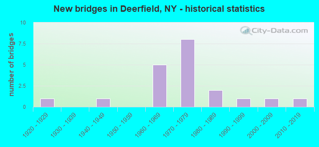
- New bridges - historical statistics
- 11920-1929
- 11940-1949
- 51960-1969
- 81970-1979
- 21980-1989
- 11990-1999
- 12000-2009
- 12010-2019
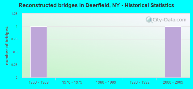
- Reconstructed bridges - Historical Statistics
- 11960-1969
- 01970-1979
- 01980-1989
- 01990-1999
- 12000-2009
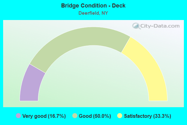
- Bridge Condition - Deck
- 16.7%Very good
- 50.0%Good
- 33.3%Satisfactory
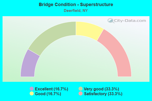
- Bridge Condition - Superstructure
- 16.7%Excellent
- 33.3%Very good
- 16.7%Good
- 33.3%Satisfactory
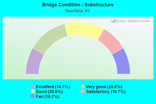
- Bridge Condition - Substructure
- 16.7%Excellent
- 25.0%Very good
- 25.0%Good
- 16.7%Satisfactory
- 16.7%Fair
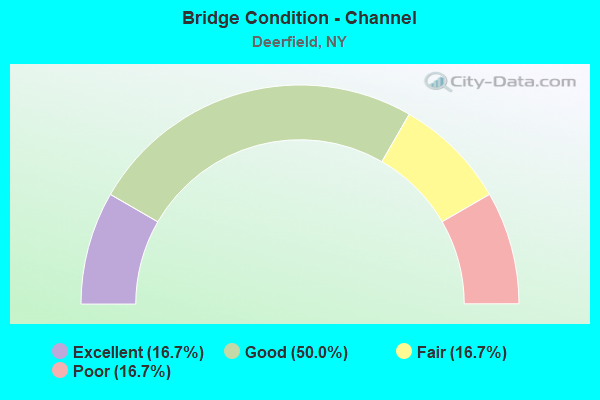
- Bridge Condition - Channel
- 16.7%Excellent
- 50.0%Good
- 16.7%Fair
- 16.7%Poor
Find on map >> Show street view
Structure Number: 105374, Location: 0.1 MI N JCT RTS 28 & 8 (Lat: 43.230442, Lng: -75.088111), Route carried "on" structure: State highway 28, Year Built: 1996, Status: Open, Structure Length: 9.24m (30.31ft), Average Daily Traffic: 2,216 (year 2020), Truck Traffic: 22%, Average Future Daily Traffic: 2,229 (year 2040), Design Load: HS 25 or greater, Features Intersected: WEST CANADA CREEK
Minimum Vertical Clearance: 30+ m (98+ ft), Kilometerpoint: 0.000, Lanes on structure: 2, Base Highway Network: Yes, Owner: State Highway Agency, Approaching Roadway Width: 12.2m (40.0ft), Skew: 1 degrees, Material/Design: Steel continuous, Design/Construction: Stringer/Multi-beam, Number Of Spans In Main Unit: 2, Length of Maximum Span: 45.4m (149.0ft), Curb-To-Curb Width: 12.2m (40.0ft), Out-to-Out Width: 12.8m (42.0ft)
Condition: Deck: Satisfactory, Superstructure: Excellent, Substructure: Good, Channel: Excellent, Inventory Rating: 40.8 metric tons, Method Used To Determine Inventory Rating: Field evaluation and documented engineering judgment, Structural Evaluation: Better than present minimum criteria, Deck Geometry: Equal to present minimum criteria, Waterway Adequacy: Equal to present desirable criteria, Approach Roadway Alignment: Equal to present desirable criteria, Length Of Structure Improvement: 9.23m (30.28ft), Designated Inspection Frequency: Every 24 months, Inspection Date: June 2020, Bridge Improvement Cost: $2,072,000, Roadway Improvement Cost: $1,214,000, Total Project Cost: $3,286,000 ( Estimate for 2021), Deck Structure Type: Concrete Cast-file-Place, Wearing Surface/Protective System: Wearing Surface: Integral Concrete, Deck Protection: Epoxy Coated Reinforcing
Find on map >> Show street view
Structure Number: 107272, Location: 3MI.SO.INT.RTES 12+8 (Lat: 43.140361, Lng: -75.215394), Route carried "on" structure: Other road , Year Built: 1983, Status: Open, Structure Length: 9.14m (29.99ft), Average Daily Traffic: 1,219 (year 2018), Truck Traffic: 4%, Average Future Daily Traffic: 1,508 (year 2040), Design Load: HS 20, Features Intersected: 12 12 26043007 SB, RTE, Facility Carried by Structure: MULANEY ROAD
Minimum Vertical Clearance: 30+ m (98+ ft), Kilometerpoint: 0.274, Lanes on structure: 3, Lanes under structure: 9, Owner: State Highway Agency, Approaching Roadway Width: 15.2m (49.9ft), Material/Design: Steel continuous, Design/Construction: Stringer/Multi-beam, Number Of Spans In Main Unit: 2, Length of Maximum Span: 50.2m (164.7ft), Curb-To-Curb Width: 15.1m (49.5ft), Out-to-Out Width: 16.0m (52.5ft)
Condition: Deck: Good, Superstructure: Good, Substructure: Very good, Operating Rating: 42.4 metric tons, Method Used To Determine Operating Rating: Load and Resistance Factor Rating (LRFR) rating reported by rating factor(RF) method using HL-93 loadings, Inventory Rating: 32.7 metric tons, Method Used To Determine Inventory Rating: Load and Resistance Factor Rating (LRFR) rating reported by rating factor(RF) method using HL-93 loadings, Structural Evaluation: Better than present minimum criteria, Deck Geometry: Equal to present minimum criteria, Underclear: Somewhat better than minimum adequacy, Approach Roadway Alignment: Equal to present desirable criteria, Length Of Structure Improvement: 9.14m (29.99ft), Designated Inspection Frequency: Every 24 months, Inspection Date: June 2021, Bridge Improvement Cost: $2,443,000, Roadway Improvement Cost: $1,430,000, Total Project Cost: $3,873,000 ( Estimate for 2021), Deck Structure Type: Concrete Cast-file-Place, Wearing Surface/Protective System: Wearing Surface: Integral Concrete, Deck Protection: Epoxy Coated Reinforcing
Find on map >> Show street view
Structure Number: 1090381, Location: 6.1 MI N JCT RTS 12 & 49 (Lat: 43.196739, Lng: -75.166736), Route carried "on" structure: State highway 12, Year Built: 1971, Status: Open, Structure Length: 3.02m (9.91ft), Average Daily Traffic: 4,828 (year 2020), Truck Traffic: 9%, Average Future Daily Traffic: 7,533 (year 2040), Design Load: HS 20, Features Intersected: CROOKED BROOK RD.
Minimum Vertical Clearance: 30+ m (98+ ft), Kilometerpoint: 46.339, Lanes on structure: 3, Lanes under structure: 2, Base Highway Network: Yes, Owner: State Highway Agency, Approaching Roadway Width: 13.7m (44.9ft), Material/Design: Steel, Design/Construction: Stringer/Multi-beam, Number Of Spans In Main Unit: 1, Length of Maximum Span: 28.9m (94.8ft), Curb-To-Curb Width: 13.7m (44.9ft), Out-to-Out Width: 14.6m (47.9ft)
Condition: Deck: Good, Superstructure: Very good, Substructure: Good, Operating Rating: 83.5 metric tons, Method Used To Determine Operating Rating: Load Factor (LF), Inventory Rating: 49.9 metric tons, Method Used To Determine Inventory Rating: Load Factor (LF), Structural Evaluation: Better than present minimum criteria, Deck Geometry: Somewhat better than minimum adequacy, Underclear: Meets minimum limits, Approach Roadway Alignment: Equal to present desirable criteria, Length Of Structure Improvement: 3.01m (9.88ft), Designated Inspection Frequency: Every 24 months, Inspection Date: April 2021, Bridge Improvement Cost: $895,000, Roadway Improvement Cost: $524,000, Total Project Cost: $1,419,000 ( Estimate for 2021), Deck Structure Type: Concrete Cast-file-Place, Wearing Surface/Protective System: Wearing Surface: Monolithic Concrete
Find on map >> Show street view
Structure Number: 1090382, Location: 6.1 MI N JCT RTS 12 & 49 (Lat: 43.196853, Lng: -75.166281), Route carried "on" structure: State highway 12, Year Built: 1971, Status: Open, Structure Length: 2.83m (9.28ft), Average Daily Traffic: 4,828 (year 2020), Truck Traffic: 9%, Average Future Daily Traffic: 7,533 (year 2040), Design Load: HS 20, Features Intersected: CROOKED BROOK RD
Minimum Vertical Clearance: 30+ m (98+ ft), Kilometerpoint: 46.339, Lanes on structure: 2, Lanes under structure: 2, Base Highway Network: Yes, Owner: State Highway Agency, Approaching Roadway Width: 7.3m (24.0ft), Material/Design: Steel, Design/Construction: Stringer/Multi-beam, Number Of Spans In Main Unit: 1, Length of Maximum Span: 27.1m (88.9ft), Curb-To-Curb Width: 12.5m (41.0ft), Out-to-Out Width: 13.4m (44.0ft)
Condition: Deck: Good, Superstructure: Very good, Substructure: Very good, Operating Rating: 78.0 metric tons, Method Used To Determine Operating Rating: Load Factor (LF), Inventory Rating: 46.3 metric tons, Method Used To Determine Inventory Rating: Load Factor (LF), Structural Evaluation: Equal to present desirable criteria, Deck Geometry: Better than present minimum criteria, Underclear: Meets minimum limits, Approach Roadway Alignment: Equal to present desirable criteria, Length Of Structure Improvement: 2.83m (9.28ft), Designated Inspection Frequency: Every 24 months, Inspection Date: April 2021, Bridge Improvement Cost: $774,000, Roadway Improvement Cost: $453,000, Total Project Cost: $1,226,000 ( Estimate for 2021), Deck Structure Type: Concrete Cast-file-Place, Wearing Surface/Protective System: Wearing Surface: Monolithic Concrete
Find on map >> Show street view
Structure Number: 109046, Location: 4.2 MI N JCT SH12 & SH49 (Lat: 43.171642, Lng: -75.184183), Route carried "on" structure: County highway , Year Built: 1971, Year Reconstructed: 2012, Status: Open, Structure Length: 8.41m (27.59ft), Average Daily Traffic: 208 (year 2017), Truck Traffic: 9%, Average Future Daily Traffic: 291 (year 2037), Design Load: HS 20, Features Intersected: 12 12 26043036 NB, RTE, Facility Carried by Structure: CR31 MILLER ROAD
Minimum Vertical Clearance: 30+ m (98+ ft), Kilometerpoint: 0.901, Lanes on structure: 2, Lanes under structure: 7, Owner: State Highway Agency, Approaching Roadway Width: 7.3m (24.0ft), Skew: 2 degrees, Material/Design: Steel continuous, Design/Construction: Stringer/Multi-beam, Number Of Spans In Main Unit: 2, Length of Maximum Span: 44.1m (144.7ft), Curb-To-Curb Width: 10.1m (33.1ft), Out-to-Out Width: 11.0m (36.1ft)
Condition: Deck: Very good, Superstructure: Very good, Substructure: Very good, Operating Rating: 51.7 metric tons, Method Used To Determine Operating Rating: Load Factor (LF), Inventory Rating: 30.8 metric tons, Method Used To Determine Inventory Rating: Load Factor (LF), Structural Evaluation: Better than present minimum criteria, Deck Geometry: Better than present minimum criteria, Underclear: Meets minimum limits, Approach Roadway Alignment: Equal to present desirable criteria, Length Of Structure Improvement: 8.41m (27.59ft), Designated Inspection Frequency: Every 24 months, Inspection Date: June 2021, Bridge Improvement Cost: $1,714,000, Roadway Improvement Cost: $1,004,000, Total Project Cost: $2,718,000 ( Estimate for 2021), Deck Structure Type: Concrete Cast-file-Place, Wearing Surface/Protective System: Wearing Surface: Monolithic Concrete
Find on map >> Show street view
Structure Number: 109047, Location: JCT OF S.H.8 & S.H.12 (Lat: 43.174872, Lng: -75.181578), Route carried "on" structure: Ramp State highway 8, Year Built: 1971, Status: Open, Structure Length: 7.01m (23.00ft), Truck Traffic: 10%, Design Load: HS 20, Features Intersected: 12NB 12 26043038, RTE 1
Minimum Vertical Clearance: 30+ m (98+ ft), Kilometerpoint: 0.595, Lanes on structure: 2, Lanes under structure: 6, Owner: State Highway Agency, Approaching Roadway Width: 13.1m (43.0ft), Skew: 30 degrees, Material/Design: Steel, Design/Construction: Stringer/Multi-beam, Number Of Spans In Main Unit: 2, Length of Maximum Span: 34.1m (111.9ft), Curb-To-Curb Width: 16.9m (55.4ft), Out-to-Out Width: 18.0m (59.1ft)
Condition: Deck: Good, Superstructure: Good, Substructure: Fair, Operating Rating: 71.7 metric tons, Method Used To Determine Operating Rating: Load Factor (LF), Inventory Rating: 42.6 metric tons, Method Used To Determine Inventory Rating: Load Factor (LF), Structural Evaluation: Somewhat better than minimum adequacy, Deck Geometry: Superior to present desirable criteria, Underclear: High priority of corrective action, Approach Roadway Alignment: Equal to present desirable criteria, Length Of Structure Improvement: 7.01m (23.00ft), Designated Inspection Frequency: Every 24 months, Inspection Date: November 2021, Bridge Improvement Cost: $2,117,000, Roadway Improvement Cost: $1,239,000, Total Project Cost: $3,356,000 ( Estimate for 2021), Deck Structure Type: Concrete Cast-file-Place, Wearing Surface/Protective System: Wearing Surface: Monolithic Concrete
Find on map >> Show street view
Structure Number: 109048, Location: 1.6 MI N JCT RTS 12 & 49 (Lat: 43.143878, Lng: -75.212892), Route carried "on" structure: State highway 921C, Year Built: 1969, Status: Open, Structure Length: 9.51m (31.20ft), Average Daily Traffic: 28,208 (year 1989), Truck Traffic: 6%, Average Future Daily Traffic: 39,491 (year 2009), Design Load: HS 20, Features Intersected: 12 12 26043405 NB, RTE
Minimum Vertical Clearance: 30+ m (98+ ft), Kilometerpoint: 1.947, Lanes on structure: 2, Lanes under structure: 5, Base Highway Network: Yes, Owner: State Highway Agency, Approaching Roadway Width: 9.1m (29.9ft), Skew: 4 degrees, Material/Design: Steel continuous, Design/Construction: Box Beam or Girders - Multiple, Number Of Spans In Main Unit: 2, Length of Maximum Span: 49.9m (163.7ft), Curb-To-Curb Width: 12.0m (39.4ft), Out-to-Out Width: 13.0m (42.7ft)
Condition: Deck: Satisfactory, Superstructure: Satisfactory, Substructure: Satisfactory, Inventory Rating: 32.7 metric tons, Method Used To Determine Inventory Rating: Field evaluation and documented engineering judgment, Structural Evaluation: Equal to present minimum criteria, Deck Geometry: Better than present minimum criteria, Underclear: Somewhat better than minimum adequacy, Approach Roadway Alignment: Equal to present desirable criteria, Length Of Structure Improvement: 9.50m (31.17ft), Designated Inspection Frequency: Every 24 months, Critical Feature Inspection Frequency: Every 24 months, Inspection Date: September 2021, Critical Feature Inspection Date: September 2021, Bridge Improvement Cost: $2,337,000, Roadway Improvement Cost: $1,368,000, Total Project Cost: $3,705,000 ( Estimate for 2021), Deck Structure Type: Concrete Cast-file-Place, Wearing Surface/Protective System: Wearing Surface: Monolithic Concrete
Find on map >> Show street view
Structure Number: 109049, Location: 2 MI N JCT S.H.12 & SH 49 (Lat: 43.147533, Lng: -75.211631), Route carried "on" structure: Ramp State highway , Year Built: 1969, Status: Open, Structure Length: 9.51m (31.20ft), Average Daily Traffic: 3,086 (year 2018), Truck Traffic: 3%, Average Future Daily Traffic: 3,748 (year 2040), Design Load: HS 20, Features Intersected: 12 12 26043407, 12 12 26, Facility Carried by Structure: GFN RAMP
Minimum Vertical Clearance: 30+ m (98+ ft), Kilometerpoint: 2.333, Lanes on structure: 2, Lanes under structure: 5, Owner: State Highway Agency, Approaching Roadway Width: 9.1m (29.9ft), Skew: 4 degrees, Material/Design: Steel continuous, Design/Construction: Box Beam or Girders - Multiple, Number Of Spans In Main Unit: 2, Length of Maximum Span: 49.9m (163.7ft), Curb-To-Curb Width: 11.9m (39.0ft), Out-to-Out Width: 12.8m (42.0ft)
Condition: Deck: Good, Superstructure: Satisfactory, Substructure: Good, Inventory Rating: 32.7 metric tons, Method Used To Determine Inventory Rating: Field evaluation and documented engineering judgment, Structural Evaluation: Equal to present minimum criteria, Deck Geometry: Superior to present desirable criteria, Underclear: High priority of corrective action, Approach Roadway Alignment: Equal to present desirable criteria, Length Of Structure Improvement: 9.50m (31.17ft), Designated Inspection Frequency: Every 24 months, Critical Feature Inspection Frequency: Every 24 months, Inspection Date: September 2021, Critical Feature Inspection Date: September 2021, Bridge Improvement Cost: $2,554,000, Roadway Improvement Cost: $1,495,000, Total Project Cost: $4,049,000 ( Estimate for 2021), Deck Structure Type: Concrete Cast-file-Place, Wearing Surface/Protective System: Wearing Surface: Monolithic Concrete
Find on map >> Show street view
Structure Number: 109427, Location: 25MI S JCT RTS 8+28 (Lat: 43.202714, Lng: -75.116664), Route carried "on" structure: State highway 8, Year Built: 1928, Year Reconstructed: 1960, Status: Open, Structure Length: 0.70m (2.30ft), Average Daily Traffic: 3,141 (year 2020), Truck Traffic: 20%, Average Future Daily Traffic: 3,160 (year 2040), Design Load: HS 20, Features Intersected: NINE MILE CREEK
Minimum Vertical Clearance: 30+ m (98+ ft), Kilometerpoint: 46.935, Lanes on structure: 2, Base Highway Network: Yes, Owner: State Highway Agency, Approaching Roadway Width: 11.0m (36.1ft), Material/Design: Concrete, Design/Construction: Slab, Number Of Spans In Main Unit: 1, Length of Maximum Span: 6.0m (19.7ft), Curb-To-Curb Width: 11.2m (36.7ft), Out-to-Out Width: 11.8m (38.7ft)
Condition: Deck: Good, Superstructure: Satisfactory, Substructure: Satisfactory, Channel: Good, Operating Rating: 45.7 metric tons, Method Used To Determine Operating Rating: Load and Resistance Factor Rating (LRFR) rating reported by rating factor(RF) method using HL-93 loadings, Inventory Rating: 35.3 metric tons, Method Used To Determine Inventory Rating: Load and Resistance Factor Rating (LRFR) rating reported by rating factor(RF) method using HL-93 loadings, Structural Evaluation: Equal to present minimum criteria, Deck Geometry: Somewhat better than minimum adequacy, Waterway Adequacy: Somewhat better than minimum adequacy, Approach Roadway Alignment: Equal to present desirable criteria, Length Of Structure Improvement: 0.70m (2.30ft), Designated Inspection Frequency: Every 24 months, Inspection Date: April 2021, Bridge Improvement Cost: $359,000, Roadway Improvement Cost: $210,000, Total Project Cost: $569,000 ( Estimate for 2021), Wearing Surface/Protective System: Wearing Surface: Bituminous, Membrane: Other
Find on map >> Show street view
Structure Number: 220565, Location: 3 MILES NORTH OF UTICA (Lat: 43.210319, Lng: -75.155936), Route carried "on" structure: Other road , Year Built: 2014, Status: Open, Structure Length: 1.40m (4.59ft), Average Daily Traffic: 65 (year 2019), Truck Traffic: 4%, Average Future Daily Traffic: 91 (year 2039), Design Load: HL 93, Features Intersected: NINE MILE CREEK, Facility Carried by Structure: CHEESE FACTORY RD
Minimum Vertical Clearance: 30+ m (98+ ft), Kilometerpoint: 1.335, Lanes on structure: 2, Owner: Town or Township Highway Agency, Approaching Roadway Width: 9.1m (29.9ft), Skew: 1 degrees, Material/Design: Prestressed concrete, Design/Construction: Box Beam or Girders - Multiple, Number Of Spans In Main Unit: 1, Length of Maximum Span: 13.4m (44.0ft), Curb-To-Curb Width: 9.2m (30.2ft), Out-to-Out Width: 10.2m (33.5ft)
Condition: Deck: Very good, Superstructure: Excellent, Substructure: Excellent, Channel: Good, Operating Rating: 50.5 metric tons, Method Used To Determine Operating Rating: Load and Resistance Factor Rating (LRFR) rating reported by rating factor(RF) method using HL-93 loadings, Inventory Rating: 38.9 metric tons, Method Used To Determine Inventory Rating: Load and Resistance Factor Rating (LRFR) rating reported by rating factor(RF) method using HL-93 loadings, Structural Evaluation: Superior to present desirable criteria, Deck Geometry: Better than present minimum criteria, Waterway Adequacy: Somewhat better than minimum adequacy, Approach Roadway Alignment: Better than present minimum criteria, Length Of Structure Improvement: 1.40m (4.59ft), Designated Inspection Frequency: Every 24 months, Inspection Date: May 2020, Bridge Improvement Cost: $522,000, Roadway Improvement Cost: $306,000, Total Project Cost: $827,000 ( Estimate for 2021), Wearing Surface/Protective System: Wearing Surface: Bituminous, Membrane: Other
Find on map >> Show street view
Structure Number: 220566, Location: 3 MI N UTICA (Lat: 43.124950, Lng: -75.205608), Route carried "on" structure: Other road , Year Built: 1961, Status: Open, Structure Length: 1.07m (3.51ft), Average Daily Traffic: 1,950 (year 2019), Truck Traffic: 6%, Average Future Daily Traffic: 2,730 (year 2039), Design Load: H 20, Features Intersected: REALL CREEK, Facility Carried by Structure: FIRE HOUSE ROAD
Minimum Vertical Clearance: 30+ m (98+ ft), Kilometerpoint: 0.483, Lanes on structure: 2, Owner: Town or Township Highway Agency, Approaching Roadway Width: 7.6m (24.9ft), Skew: 3 degrees, Material/Design: Steel, Design/Construction: Culvert, Number Of Spans In Main Unit: 2, Length of Maximum Span: 4.5m (14.8ft)
Condition: Channel: Poor, Culverts: Fair, Operating Rating: 72.8 metric tons, Method Used To Determine Operating Rating: Field evaluation and documented engineering judgment, Inventory Rating: 29.4 metric tons, Method Used To Determine Inventory Rating: Field evaluation and documented engineering judgment, Structural Evaluation: Somewhat better than minimum adequacy, Waterway Adequacy: Meets minimum limits, Approach Roadway Alignment: Equal to present minimum criteria, Length Of Structure Improvement: 1.06m (3.48ft), Designated Inspection Frequency: Every 24 months, Inspection Date: August 2021, Bridge Improvement Cost: $158,000, Roadway Improvement Cost: $93,000, Total Project Cost: $251,000 ( Estimate for 2021)
Find on map >> Show street view
Structure Number: 331056, Location: 3.0 MI.E.OF RTE.8 & 12 (Lat: 43.207175, Lng: -75.143497), Route carried "on" structure: Other road , Year Built: 1949, Status: Open, Structure Length: 1.55m (5.09ft), Average Daily Traffic: 175 (year 2019), Truck Traffic: 4%, Average Future Daily Traffic: 245 (year 2039), Design Load: H 20, Features Intersected: NINE MILE CREEK, Facility Carried by Structure: CROOKED BROOK RD
Minimum Vertical Clearance: 30+ m (98+ ft), Kilometerpoint: 4.859, Lanes on structure: 2, Owner: Town or Township Highway Agency, Approaching Roadway Width: 6.7m (22.0ft), Material/Design: Steel, Design/Construction: Stringer/Multi-beam, Number Of Spans In Main Unit: 1, Length of Maximum Span: 14.6m (47.9ft), Curb-To-Curb Width: 7.5m (24.6ft), Out-to-Out Width: 7.7m (25.3ft)
Condition: Deck: Satisfactory, Superstructure: Satisfactory, Substructure: Fair, Channel: Fair, Operating Rating: 57.2 metric tons, Method Used To Determine Operating Rating: Field evaluation and documented engineering judgment, Inventory Rating: 23.4 metric tons, Method Used To Determine Inventory Rating: Field evaluation and documented engineering judgment, Structural Evaluation: Somewhat better than minimum adequacy, Deck Geometry: Somewhat better than minimum adequacy, Waterway Adequacy: Meets minimum limits, Approach Roadway Alignment: Equal to present minimum criteria, Length Of Structure Improvement: 1.55m (5.09ft), Designated Inspection Frequency: Every 24 months, Inspection Date: July 2020, Bridge Improvement Cost: $406,000, Roadway Improvement Cost: $238,000, Total Project Cost: $644,000 ( Estimate for 2021), Deck Structure Type: Concrete Cast-file-Place, Wearing Surface/Protective System: Wearing Surface: Bituminous
Find on map >> Show street view
Structure Number: 331057, Location: 7 MI N UTICA (Lat: 43.207181, Lng: -75.161694), Route carried "on" structure: Other road , Year Built: 2004, Status: Open, Structure Length: 2.29m (7.51ft), Average Daily Traffic: 65 (year 2019), Truck Traffic: 4%, Average Future Daily Traffic: 91 (year 2039), Design Load: HS 25 or greater, Features Intersected: NINE MILE CREEK, Facility Carried by Structure: CHEESE FACTORY RD
Minimum Vertical Clearance: 30+ m (98+ ft), Kilometerpoint: 0.628, Lanes on structure: 2, Owner: County Highway Agency, Approaching Roadway Width: 6.1m (20.0ft), Skew: 2 degrees, Material/Design: Prestressed concrete, Design/Construction: Box Beam or Girders - Multiple, Number Of Spans In Main Unit: 1, Length of Maximum Span: 21.9m (71.9ft), Curb-To-Curb Width: 8.2m (26.9ft), Out-to-Out Width: 9.1m (29.9ft)
Condition: Deck: Satisfactory, Superstructure: Very good, Substructure: Excellent, Channel: Good, Inventory Rating: 82.6 metric tons, Method Used To Determine Inventory Rating: Load Factor (LF), Structural Evaluation: Equal to present desirable criteria, Deck Geometry: Equal to present minimum criteria, Waterway Adequacy: Somewhat better than minimum adequacy, Approach Roadway Alignment: Meets minimum limits, Length Of Structure Improvement: 2.28m (7.48ft), Designated Inspection Frequency: Every 24 months, Inspection Date: May 2020, Bridge Improvement Cost: $429,000, Roadway Improvement Cost: $251,000, Total Project Cost: $680,000 ( Estimate for 2021), Deck Structure Type: Concrete Cast-file-Place, Wearing Surface/Protective System: Wearing Surface: Integral Concrete, Deck Protection: Galvanized Reinforcing
Find on map >> Show street view
Structure Number: 107272, Location: 3MI.SO.INT.RTES 12+8 (Lat: 43.140361, Lng: -75.215394), Route carried "under" structure: State highway 12, Year Built: 1983, Structure Length: 0. m, Average Daily Traffic: 12,560 (year 2000), Features Intersected: 12 12 26043007 SB, RTE, Facility Carried by Structure: MULANEY ROAD
Minimum Vertical Clearance: 4.57m (14.99ft), Kilometerpoint: 38.487, Lanes on structure: 3, Lanes under structure: 3, Material/Design: Steel continuous, Design/Construction: Stringer/Multi-beam, Length of Maximum Span: 50.2m (164.7ft)
Find on map >> Show street view
Structure Number: 1090381, Location: 6.1 MI N JCT RTS 12 & 49 (Lat: 43.196739, Lng: -75.166736), Route carried "under" structure: County highway , Year Built: 1971, Structure Length: 0. m, Features Intersected: CROOKED BROOK RD., Facility Carried by Structure: RTE 12
Minimum Vertical Clearance: 4.93m (16.17ft), Kilometerpoint: 2.446, Lanes on structure: 3, Lanes under structure: 2, Material/Design: Steel, Design/Construction: Stringer/Multi-beam, Length of Maximum Span: 28.9m (94.8ft)
Find on map >> Show street view
Structure Number: 1090382, Location: 6.1 MI N JCT RTS 12 & 49 (Lat: 43.196853, Lng: -75.166281), Route carried "under" structure: County highway , Year Built: 1971, Structure Length: 0. m, Features Intersected: CROOKED BROOK RD, Facility Carried by Structure: RTE 12
Minimum Vertical Clearance: 4.52m (14.83ft), Kilometerpoint: 0.000, Lanes on structure: 2, Lanes under structure: 2, Material/Design: Steel, Design/Construction: Stringer/Multi-beam, Length of Maximum Span: 27.1m (88.9ft)
Find on map >> Show street view
Structure Number: 109046, Location: 4.2 MI N JCT SH12 & SH49 (Lat: 43.171642, Lng: -75.184183), Route carried "under" structure: State highway 12, Year Built: 1971, Structure Length: 0. m, Average Daily Traffic: 13,740 (year 2000), Features Intersected: 12 12 26043036 NB, RTE, Facility Carried by Structure: CR31 MILLER ROAD
Minimum Vertical Clearance: 6.32m (20.73ft), Kilometerpoint: 50.684, Lanes on structure: 2, Lanes under structure: 4, Material/Design: Steel continuous, Design/Construction: Stringer/Multi-beam, Length of Maximum Span: 44.1m (144.7ft)
Find on map >> Show street view
Structure Number: 109047, Location: JCT OF S.H.8 & S.H.12 (Lat: 43.174872, Lng: -75.181578), Route carried "under" structure: State highway 12, Year Built: 1971, Structure Length: 0. m, Average Daily Traffic: 3,800 (year 1972), Features Intersected: 12NB 12 26043038, RTE 1, Facility Carried by Structure: RTE 8
Minimum Vertical Clearance: 4.37m (14.34ft), Kilometerpoint: 6.935, Lanes on structure: 2, Lanes under structure: 3, Material/Design: Steel, Design/Construction: Stringer/Multi-beam, Length of Maximum Span: 34.1m (111.9ft)
Find on map >> Show street view
Structure Number: 109048, Location: 1.6 MI N JCT RTS 12 & 49 (Lat: 43.143878, Lng: -75.212892), Route carried "under" structure: State highway 12, Year Built: 1969, Structure Length: 0. m, Average Daily Traffic: 12,560 (year 2000), Features Intersected: 12 12 26043405 NB, RTE, Facility Carried by Structure: RTE 921C
Minimum Vertical Clearance: 4.83m (15.85ft), Kilometerpoint: 1.673, Lanes on structure: 2, Lanes under structure: 2, Material/Design: Steel continuous, Design/Construction: Box Beam or Girders - Multiple, Length of Maximum Span: 49.9m (163.7ft)
Find on map >> Show street view
Structure Number: 109049, Location: 2 MI N JCT S.H.12 & SH 49 (Lat: 43.147533, Lng: -75.211631), Route carried "under" structure: State highway 12, Year Built: 1969, Structure Length: 0. m, Average Daily Traffic: 11,123 (year 2000), Features Intersected: 12 12 26043407, 12 12 26, Facility Carried by Structure: GFN RAMP
Minimum Vertical Clearance: 4.70m (15.42ft), Kilometerpoint: 2.076, Lanes on structure: 2, Lanes under structure: 2, Material/Design: Steel continuous, Design/Construction: Box Beam or Girders - Multiple, Length of Maximum Span: 49.9m (163.7ft)